|
|
|
AGENDA
Ordinary Council Meeting
Tuesday, 26 February 2019
|
|
I hereby give notice that an Ordinary Meeting of
Murray River Council will be held on:
|
|
Date:
|
Tuesday, 26 February
2019
|
|
Time:
|
6:00PM
|
|
Location:
|
Tatalia Room, Upper Level,
Rich River Golf Club
24 Lane, Moama
|
|
Des Bilske
General Manager
|
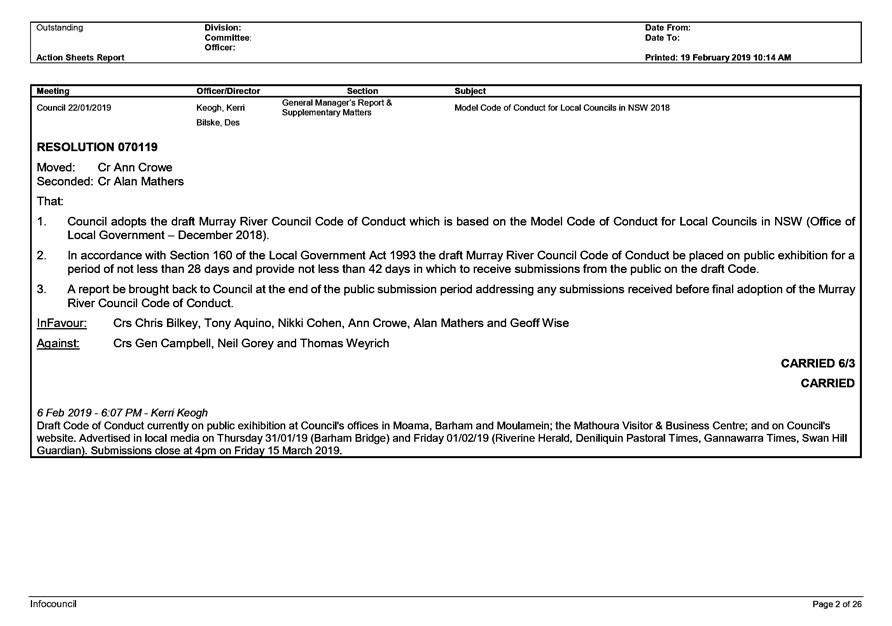
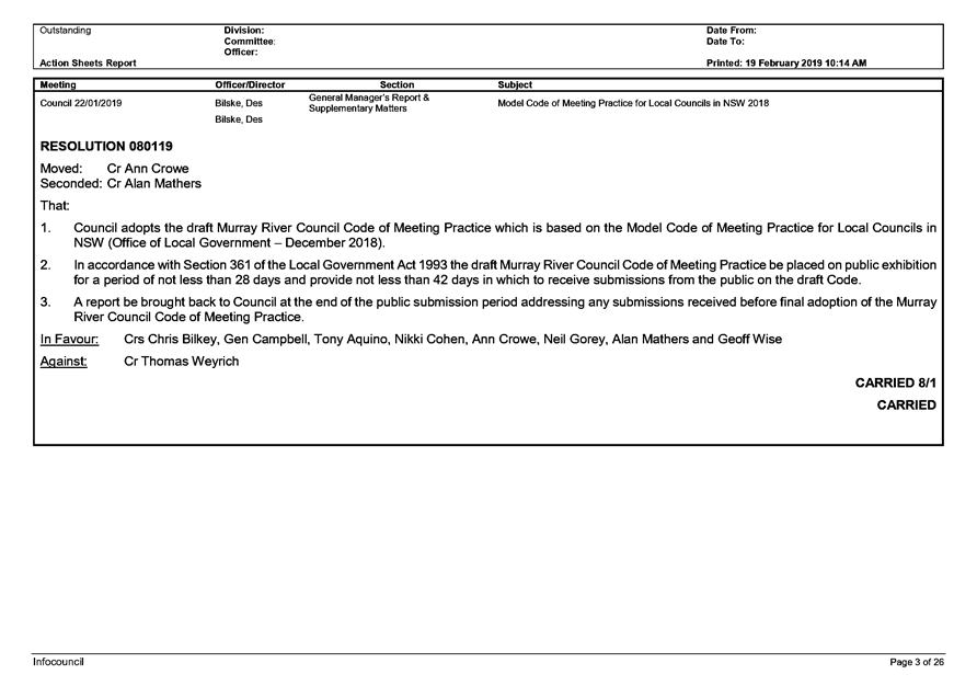
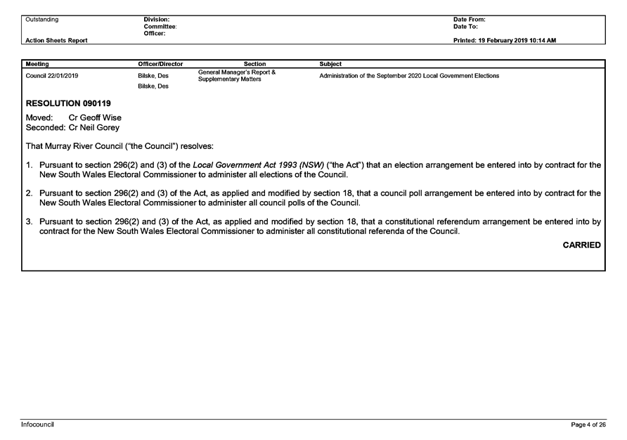
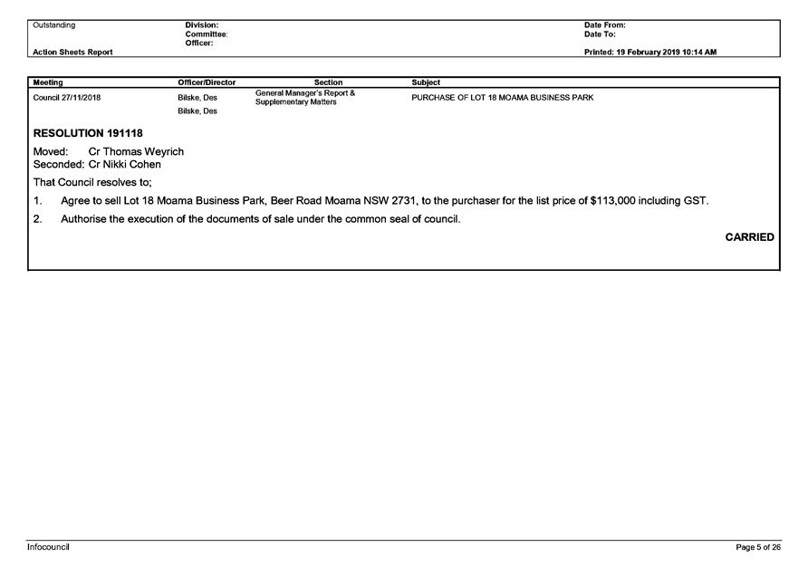
5 Confirmation
of Minutes
5.1 Confirmation
of minutes from the Ordinary Council Meeting held 22 January 2019.
File
Number: -
Author: Rosemarie
Lewandowski, Administration Officer Project
Authoriser: Des
Bilske, General Manager
|
Recommendation
That the minutes of the Ordinary Meeting of Murray River
Council held on 22 January 2019 be confirmed as a true and correct record.
|
Discussion
Murray River Council held its Ordinary Meeting of Council on
Tuesday 22 January 2019 commencing at 6:00pm in the Tatalia Room, Upper level
Rich River Golf Club, 24 Lane Moama.
A copy of the draft minutes are attached for ratification by
the Council at this meeting.
Attachments
1. Ordinary
Meeting of Council_22 January 2019_MINUTES_DRAFT ⇩ 
|
Ordinary Council Meeting Agenda
|
26 February 2019
|


9 Notices
of Motion/Notices of Rescission
9.1 Notice
of Motion - Councillor Attendance at Women in Local Government Forum -
Leadership Across the Riverina Murray; and LGNSW Tourism Conference
File
Number: -
I, Councillor Gen Campbell, give notice that at the next
Ordinary Meeting of Council to be held on 26 February 2019, I intend to move
the following motion:
|
Motion
1. That Council
considers the attendance of Councillors at the Women in Local Government
Forum – Leadership Across the Riverina to be held on 13 March 2019 in
Wagga Wagga.
2. That Council
considers the attendance of Councillors at the Local Government NSW Tourism
Conference to be held from 17 to 19 March 2019 in Terrigal NSW.
|
Rationale
1. Wagga
Wagga City Council is hosting a Women in Local Government Forum –
Leadership Across the Riverina Murray on Wednesday 13 March 2019. Wagga
Wagga City Council is hosting this event free of charge for councils in the
Riverina Murray region. The forum allows female leaders in local government
from across the Riverina Murray region to step away and come together. The
forum is for elected members and senior staff, enabling a dialogue around women
in leadership, female representation and key issues in local government.
Keynote speakers are Linda Scott, Deputy Mayor City of Sydney and President of
Local Government NSW; and Ruth McGowan, Consultant Local Government and Gender
Equity. The forum will be split into two sessions – Session 1 is for
Elected Members (10:00am – 12:00pm) and Session 2 is for Council Senior
Staff (1:00pm – 4:00pm).
2. The
Local Government NSW (LGNSW) Tourism Conference will be held from 17 to
19 March 2019 at the Crowne Plaza Terrigal. LGNSW's
Tourism Conference gives councillors and council staff the opportunity to meet,
listen to experts and peers, and find out how other councils are engaging and
managing their tourism industry. This year’s theme, Experience
Changes Perceptions, aligns with the NSW Government’s $2M NSW
Road Trips campaign to entice travellers to experience metropolitan, rural and
regional offerings off the major highways and into rural and regional towns. The theme relates to creating tourism experiences that will
attract and sustain a local and visiting audience, investment, partnerships and
content development. The theme also looks at how to address assumptions
tourists make about destinations and how we can change visitor perceptions with
real experiences and technology. To view a copy of the conference draft
program, please visit:
https://www.lgnsw.org.au/events-training/lgnsw-tourism-conference/program-5
I commend this Notice of Motion to Council.
Attachments
Nil
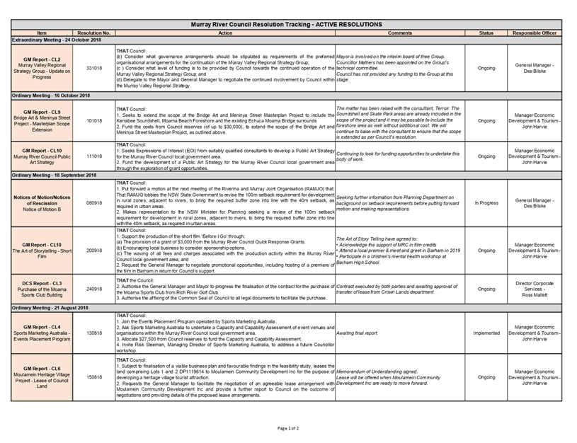
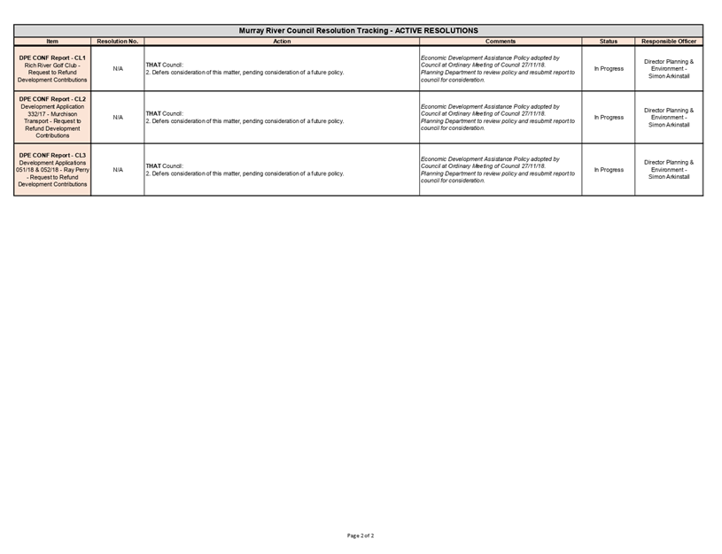
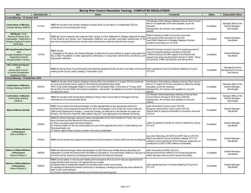
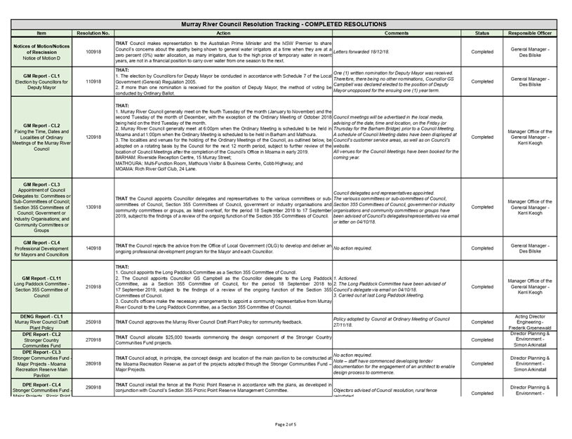
10 General
Manager’s Report & Supplementary Matters
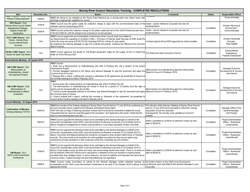
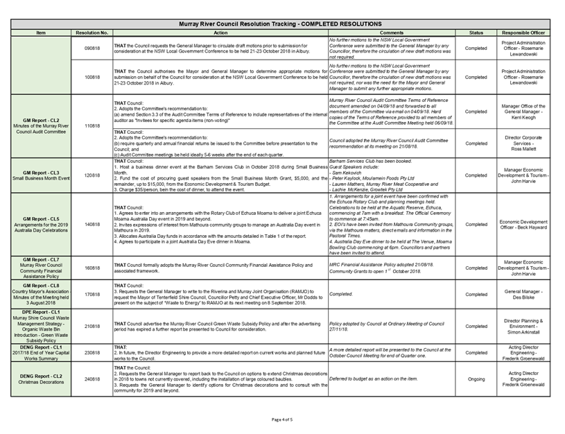
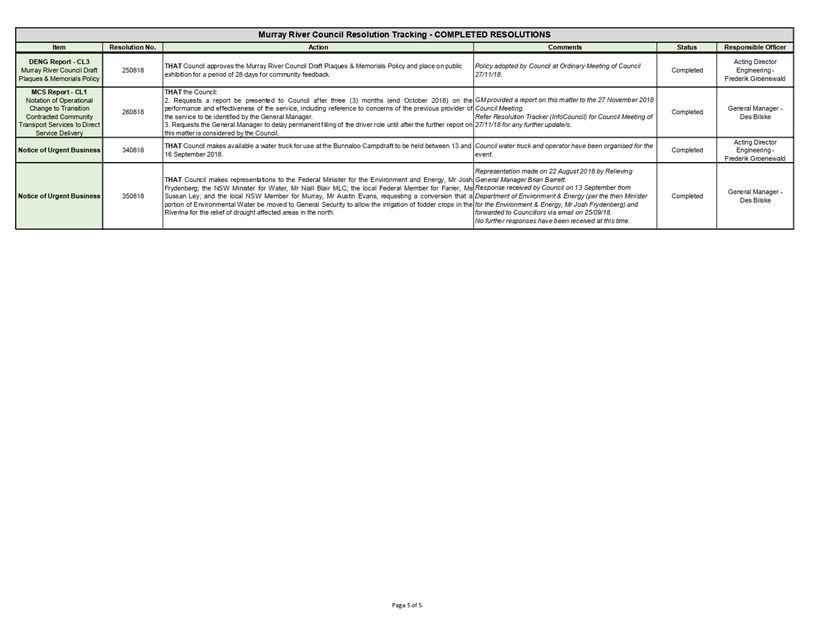
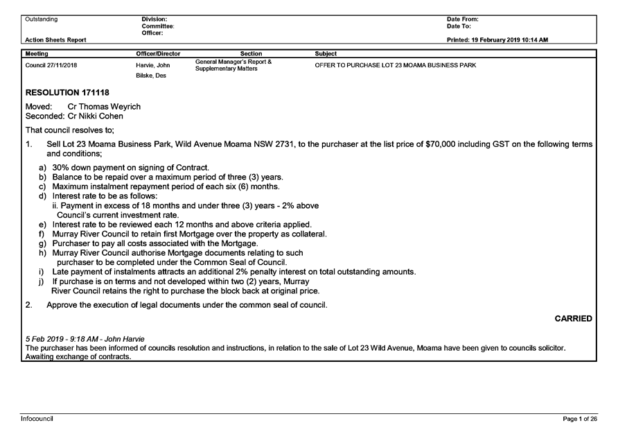
10.1 Council's
Resolution Tracker
File
Number: -
Author: Rosemarie
Lewandowski, Administration Officer Project
Authoriser: Des
Bilske, General Manager
|
Recommendation
That Council receives and notes the status of previous
resolutions of Council on both manual and INFOCOUNCIL Resolution tracker
reports.
|
Background
The Council Resolutions Tracker has been prepared to allow Councillors
to review the status of their decisions (resolutions) at Council Meetings.
The manual Tracker comprises two (2) lists –
‘active’ and ‘completed’ and includes all resolutions
from the previous meetings of the Council that require action. The resolutions
that are reported by Council’s officers as complete will drop off the
‘active’ list and be captured on the ‘completed’ list.
The Resolutions Tracker from INFOCOUNCIL is attached
along with the previous manually generated Tracker which will be archived once
all resolutions on it have been completed.
Discussion
For Council information.
Strategic Implications
5 - Strategic Theme 5: Leadership and Governance
5.1 - An effective, efficient and progressive Council that
provides leadership to the community
5.1.1 - Council decision making takes into account the needs
and priorities of our local communities and the longer term social, cultural,
economic and environmental viability and sustainability of our region
Budgetary Implications
Nil.
Policy Implications
Nil.
Legislative Implications
Nil.
Risk Analysis
· What
can happen? Directors and or staff do not follow up on the resolutions.
· How
can it happen? Resolutions being overlooked or misplaced
· What
are the consequences of the event happening? Resolutions not being completed in
a timely manner
· What
is the likelihood of the event happening? Low
· Adequacy
of existing controls? Executive assistant and Admin assistant email the
resolutions to Council Officers for actioning. EA and AA follow up with
reminders to Council Officers for completion of resolutions.
· Treatment
options to mitigate the risk? Due diligence undertaken by administration and
Council Officers
Conclusion
The Council Resolutions Tracker has been prepared to allow Councillors
to review the status of their decisions (resolutions). The Tracker was
introduced in September 2018 and includes all resolutions made by Council after
that period that require action. The resolutions that are reported by
Council’s officers as complete will drop off the manual ‘active’
list and be captured on the ‘completed’ list.
The INFOCOUNCIL list will contain both active and completed
actions for a period of twelve months. This process will take place for every
Council Meeting.
Attachments
1. Manual
Resolution Tracker_19 February 2019 ⇩ 
2. INFOCOUNCIL
Resolution Tracker Feb 2019 ⇩
|
Ordinary Council Meeting Agenda
|
26 February 2019
|
|
Ordinary
Council Meeting Agenda
|
26 February 2019
|
10.2 Discussion
on Evening Council Meetings
File
Number: -
Author: Des
Bilske, General Manager
Authoriser: Des
Bilske, General Manager
|
Recommendation
That Council reschedule council meetings from daytime to
evening meetings and advertise the new schedule.
1. Type Recommendation here
(a) Type
Recommendation here
(i) Type Recommendation here
|
Background
The Council has a request to consider holding council
meetings of an evening to allow for continued access by all current
councillors. Council has requested they be presented with benefits and
disadvantages for holding meetings of an evening.
Discussion
The following matters have been identified for
consideration:
Benefits:
1. The
majority of councillors will find it easier with council meeting of an evening
to run existing businesses or employment opportunities.
2. Evening
meetings generally provide for greater numbers of members of the public being
able to attend the meetings.
3. The
whole day is free for pre-meeting workshops and briefings as required.
4. Council
meetings have a lower impact on the day to day operation of council on meeting
days.
5. Having
remote councillors stay overnight may allow for additional workshops on the day
following council meetings.
6. Conducting
workshops and council meetings at the same time reduces the overall travel
costs.
Disadvantages:
1. Some
councillors, staff or community members may not be able to attend night
meetings because of family commitments.
2. Travel
for councillors, staff, members of public is at higher risk than during daytime
because of wildlife on roadways.
3. Some
of the staff required for meetings may attract time in lieu or overtime for the
duration of the meeting.
4. Some
support staff may not be available during meetings. e.g. ITC staff.
5. Evening
meetings may increase the accommodation costs for councillors as all remote
councillors will be entitled to stay overnight.
There are many councils both nearby and especially in metro
areas that conduct all their council meetings of an evening to allow for all
councillors to attend and provide better access by members of the public.
Strategic Implications
5 - Strategic Theme 5: Leadership and Governance
5.2 - Engaged community leadership
5.2.3 - Foster community leadership opportunities and
development
Budgetary Implications
There will be minimal budgetary implications of this report.
Policy Implications
Murray River Council Code of Meeting Practice (POL101).
Legislative Implications
Local Government Act 1993.
Risk Analysis
· What
can happen?
Type here
· How
can it happen?
Type here
· What
are the consequences of the event happening?
Type here
· What
is the likelihood of the event happening?
Type here
· Adequacy
of existing controls?
Type here
· Treatment
options to mitigate the risk?
Type here
Conclusion
There are some overall benefits for council to conduct all
scheduled council meetings of an evening.
Attachments
Nil
10.3 Proposed
Change of Date for April Ordinary Meeting of Council
File
Number: -
Author: Rosemarie
Lewandowski, Administration Officer Project
Authoriser: Des
Bilske, General Manager
|
Recommendation
That Council approve a change of date for the April
Ordinary meeting of Council from 23 April 2019 to 16 April 2019 due to Easter
and Anzac Day falling within the same week of the Council meeting.
|
Background
At the September 2018 Ordinary meeting of Council the dates,
times and locations for the next Council meetings were set until September
2019. It was not apparent at this time that the Ordinary meeting of
Council in April would coincide with the end of the Easter break and Anzac day
in the same week.
Discussion
Consideration be given to bringing the April Ordinary
meeting of council forward to 16 April 2019 to allow for the business papers to
be generated in a timely manner, Council meeting to be held with all in
attendance and to allow Councillors and staff to plan an extended break
over the Easter and Anzac Day period if they wish.
Strategic Implications
5 - Strategic Theme 5: Leadership and Governance
5.1 - An effective, efficient and progressive Council that
provides leadership to the community
5.1.1 - Council decision making takes into account the needs
and priorities of our local communities and the longer term social, cultural,
economic and environmental viability and sustainability of our region
Budgetary Implications
Nil.
Policy Implications
Murray River Council Code of Meeting Practice (POL101).
Legislative Implications
Local Government Act 1993.
Local Government (General) Regulations 2005.
Risk Analysis
· What
can happen? Minimal disruption to scheduling of April meeting
· How
can it happen? Business papers are required earlier and cannot be produced
· What
are the consequences of the event happening? Business papers not be
available for Councillors by due date and time
· What
is the likelihood of the event happening? Low
· Adequacy
of existing controls? Provided the Information and Communications
technology is working efficiently then the business paper should be produced in
a timely manner.
· Treatment
options to mitigate the risk? Move to another location to print and collate
business paper
Conclusion
Approval given for the rescheduling of the April Ordinary
meeting of Council.
Attachments
Nil
10.4 ABC
'Get Krackin' Television Program
File
Number: -
Author: John
Harvie, Manager Economic Development & Tourism
Authoriser: Des
Bilske, General Manager
|
Recommendation
That Council:
1. Request the
General Manager write a letter of complaint to the ABC highlighting the
negative impact that episode 1 of Series 2 of the Get Krackin program may have
on visitation to Echuca Moama at a time when our community is relying heavily
on tourism to underpin our local economy during the current drought.
2. Develop a policy
and procedure to ensure, as far as possible, that program content filmed
within the Murray River Council LGA that depicts or refers to our communities
does not offend, demean or cause affront.
|
Background
The ABC television program ‘Get Krackin’ aired
an episode on Wednesday 6 February featuring Echuca Moama.
The promo for the program described the episode thus;
‘It's the final stop of Get Krack!n's "We Bloody Love
Australia" tour where The Kates find themselves aboard a paddle-steamer on
the Mighty Murray River during a hostile weather event that threatens to derail
the broadcast’.
The show, unfortunately, featured vulgar language, was in
extremely poor taste and an affront to the communities of Echuca and Moama.
Councillors had asked officers to follow up and report on
how the program came to feature Echuca Moama.
Discussion
Council General Manager discussed
the matter with Shire of Campaspe who advised that there was an
application for filming placed with their Council mid last year and approved as
there was no reason for refusal.
The approval was given for filming
of a satirical program based on the commercial TV program “Get
Away” and a send up of the morning breakfast shows.
Shire of Campaspe staff requested
in writing that the satire should be in good taste, however, under an
application for filming there is no ability to dictate editorial content,
therefore, council did not get to see any of the product before it went to air.
The hiring of the Pevensey was
undertaken as a commercial transaction by the ABC program.
The Program Directors consulted
with Echuca Moama Tourism and the owners of the Pevensey only to the extent of
obtaining ideas for the best locations for filming to showcase the area.
Murray River Council officers also
contacted Echuca Moama Tourism and Murray Regional Tourism Board to ascertain
whether there was any collaboration or agreement between those organisations in
the production and broadcasting of the program.
Both organisations confirmed that
they had not been involved in procuring or promoting Echuca Moama to the
producers of the show and further that neither organisation had been approached
or provided funding to have the program filmed here.
The Shire of Campaspe, Echuca
Moama Tourism and Murray Regional Tourism Board are all as disappointed and
appalled with the content of the program and the timing of airing as MRC.
Wendy Greiner, Chair of MRTB has stated that they will be taking action to
express their feelings to each of the organisations involved in the production.
Strategic Implications
5 - Strategic Theme 5: Leadership and Governance
5.4 - Develop and pursue advocacy on behalf of the community
5.4.1 - Pursue advocacy on key issues of importance to the
community and Council
Budgetary Implications
Nil.
Policy Implications
Nil.
Legislative Implications
Nil.
Risk Analysis
· What
can happen? NIL
· How
can it happen? NIL
· What
are the consequences of the event happening? NIL
· What
is the likelihood of the event happening? NIL
· Adequacy
of existing controls? NIL
· Treatment
options to mitigate the risk? NIL
Conclusion
When council receives an application to film at sites within
the Murray River Council Local Government Area, the applicant should be
required to provide details of the program being produced, the likely
distribution and the intended audience.
Further research should be undertaken by council officers to
determine whether the final product is one which aligns with the values of
council and our communities.
Attachments
Nil
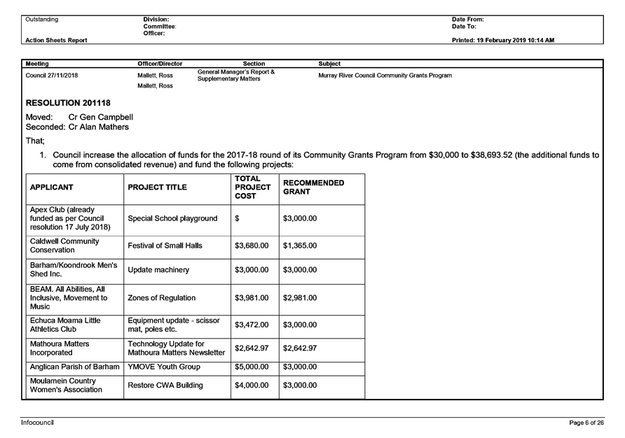
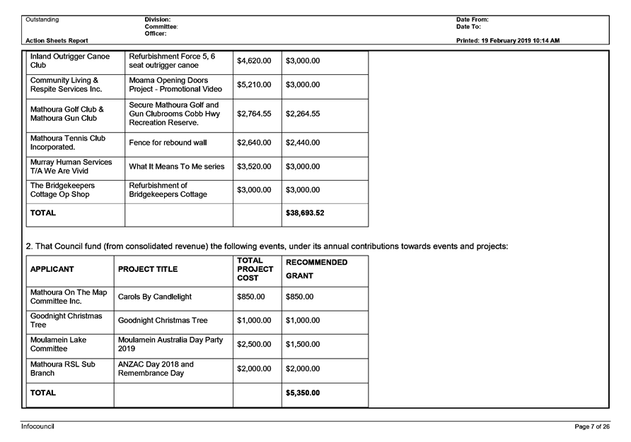
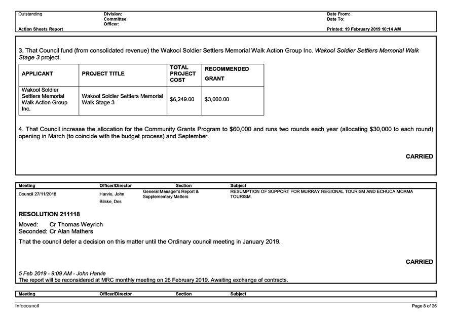
10.5 MURRAY
RIVER COUNCIL COMMUNITY GRANTS PROGRAM – APPOINTMENT OF ASSESSMENT PANEL
File
Number: -
Author: John
Harvie, Manager Economic Development & Tourism
Authoriser: Des
Bilske, General Manager
|
Recommendation
That Council:
1. Endorses the General Manager, or his nominee, as a member of the
Murray River
Council Community Grants Program Assessment Panel.
2. Appoints three (3) Councillors to the Murray River Council Community
Grants Program
Assessment Panel.
|
Background
Council ran the first round of the Murray River Council Community Grants
Program in September 2018 and awarded $38,693.52 in grants.
At its 27 November 2018 meeting, Council agreed to run two rounds per
financial year, allocating $30,000 to each round.
The round 1 assessment panel comprised:
· Des
Bilske, General Manager
· Cr
Cohen
· Cr
Mathers and
· Cr
Weyrich.
Round 2 of the 2018-19 Murray River Council Community Grants Program will
open in March 2019. The timeline for this round (see table below) will require
the assessment panel to assess applications, starting 17 April 2019. Assessment
of the applications will be undertaken both online and via meeting and
discussion.
Appointment of the assessment panel at Council’s February 2019
meeting will assist in the smooth planning of the assessment process.
Round 2 - Timeline
|
Applications open
|
Friday 1 March 2019
|
|
Applications close
|
Monday 15 April 2019
|
|
Judges time to review
applications
|
Wednesday 17 April –
Friday 3 May 2019
|
|
Judges meet to allocate
funding
|
Tuesday 7 May 2019
|
|
Report to Council meeting
|
Tuesday 28 May 2019
|
|
Notify applicants
|
Friday 31 May 2019
|
|
Invoices received and paid by
|
30 June 2019
|
Discussion
The grants are competitive in nature as Council will generally receive
applications with a total value in excess of the $30,000 allocated for the
round.
As a result, it is necessary that Council form an assessment panel to
review the grant applications and make recommendations in relation to which
applications should be funded and to what amount.
It is suggested that the assessment panel comprise the General Manager
(or his nominee) and three
(3) Councillors.
Council’s Economic Development Officer, Beck Hayward, manages the
grant program and will assist the assessment panel during the assessment
process.
Strategic Implications
3 - Strategic Theme 3: Social Wellbeing
3.4 - Encourage skills development and lifelong learning
3.4.1 - Support active lifelong learning and skill
development for people of all ages and abilities
Budgetary Implications
There are no additional budgetary implications, as $30,000 has been
included in the 2018/19 budget (as per 27 November 2019 resolution of Council) to
fund Round 2 of the Community Grants Program.
Policy Implications
Murray River Council Community Financial Assistance Policy
(POL109).
Legislative Implications
Nil.
Risk Analysis
· What
can happen? NIL
· How
can it happen? NA
· What
are the consequences of the event happening? NA
· What
is the likelihood of the event happening? NA
· Adequacy
of existing controls? NA
· Treatment
options to mitigate the risk? NA
Conclusion
Council needs to appoint members to the Murray River Council Community
Grants Program
Assessment Panel.
Attachments
Nil
10.6 Town
Crier Funding - Previously Approved
File
Number: -
Author: John
Harvie, Manager Economic Development & Tourism
Authoriser: Des
Bilske, General Manager
|
Recommendation
That Council request the event organiser to apply for funding under the
next round of Council’s Community Grants Program as per Council’s
Community Financial Assistance Policy (POL109).
|
Background
At its meeting on Tuesday 15 May 2018, Council resolved the following:
080518 RESOLVED
1. That Council support
Council’s Town Crier in hosting the World Invitational Town Crier
Tournament and Australian Guild National Town Crier Championships, to be held
from 15 to 24 March 2019 at various venues throughout the Murray River Council
and Shire of Campaspe areas.
2. That Council commit an
amount of $5,000 (capped), being $3,000 initially and if the further $2,000 is
required, a report be presented to the Council with a detailed explanation of
why the funds are required, to the World Invitational Town Crier Tournament and
Australian Guild National Town Crier Championships; and the funds be
subsequently referred to Council’s 2018/19 budget for consideration.
The event is no longer being held in May 2019. It has been rescheduled to
be held in October 2019.
Discussion
The event organiser, Town Crier Judy Campbell, has requested that the
payment of $3,000 be made this month. As the date of the event has been put
back seven months, the event is now proposed to be held in October 2019 which
is in the next financial year (2019-20).
Sponsorship payment for events are generally made within the same
financial year in which the event is held. There is however no allocation for
this event currently in the 2019-20 budget.
Council may like to consider the following:
· Approve
payment of the event sponsorship in the current financial year (even though the
event is being held in next financial year), or
· Request
the event organiser to apply for funding under the next round of
Council’s Community Grants Program - as per Council’s Community
Financial Assistance Policy (POL109).
Strategic Implications
4 - Strategic Theme 4: Economic Growth
4.2 - Continue focus on strong and vibrant tourism
4.2.3 - Promote and encourage local, state and national
events
Budgetary Implications
There is no allocation for this event currently in the 2019-20 budget.
Policy Implications
Murray River Council Community Financial Assistance Policy
(POL109).
Legislative Implications
Nil.
Risk Analysis
· What
can happen? NIL
· How
can it happen? NA
· What
are the consequences of the event happening? NA
· What
is the likelihood of the event happening? NA
· Adequacy
of existing controls? NA
· Treatment
options to mitigate the risk? NA
Conclusion
Council should consider how to best fund sponsorship of the Town Crier
event.
Attachments
Nil
10.7 Echuca
Moama Apex Gift - Funding Request
File
Number: -
Author: John
Harvie, Manager Economic Development & Tourism
Authoriser: Des
Bilske, General Manager
|
Recommendation
That Council:
1. Consider the
funding request from Echuca Moama Apex;
2. Approve $3,000
grant funding to the Echuca Moama Apex Gift from the 2018/2019 Quick Response
Grant Program; and
3. Determine that
grant funding provided is not to be used for prize money.
|
Background
The Apex Club of Echuca Moama created a new sporting event
named the Echuca Moama Apex Gift. The fast format, twilight, 100metre
event was run, at Jack Eddy Oval, during March 2018 and was a huge success.
Eight local football / netball clubs competed in the family
friendly event with categories comprising under18 girls, under 18 boys, senior
netballer & senior footballer.
Council contributed $1000 towards the running of the event
in 2018 and the event was a huge success.
Discussion
The 2019 event will be run again at the Jack Eddy Oval on
March 1 and will be bigger and better than the inaugural event. $5000
total Prizemoney is up for grabs with each club paying an entry fee of $250 to enter eight runners, split between
four categories: under-18 boys, under-18 girls, senior men and senior women.
The projected budget for 2019 is twenty thousand dollars, up
45 per cent on last year.
Council has received a request for funding for the 2019
event. The request has and the event will occur outside of the application
window for round 2 of councils community grants program.
Under the program guidelines retrospective funding of events
is not permitted.
The only avenue open to council to grant funding for the
2019 event is through the Quick Response Grant which can be used under the
following conditions;
QUICK RESPONSE GRANTS
The intended purpose of the Murray River Council Quick
Response Grant is to provide council with an opportunity to fund worthy and extraordinary
opportunities that were not able to be considered for funding as part of the
community grants process.
The quick response grant offers financial support to
not-for-profit community organisations and groups for extraordinary and worthy
projects, equipment, events, exhibitions, or performances which contribute
positively to the Murray River community.
The Quick Response Grant aims to:
· Enable council
to fund projects that have not previously been considered for funding.
· Enable council
to support opportunities that are one-off, or which have arisen outside of
application periods for other council financial assistance.
· Assist council
to deliver identified objectives, priorities and strategies that align with the
Community Strategic Plan.
Strategic Implications
4 - Strategic Theme 4: Economic Growth
4.2 - Continue focus on strong and vibrant tourism
4.2.3 - Promote and encourage local, state and national
events
Budgetary Implications
$10,000 has been allocated to fund the Quick Response Grant
Program in the 2018/19 budget. No allocations have been made during 2018/19 and
the fund has $10,000 available.
Policy Implications
Murray River Council Community Financial Assistance Policy
(POL109).
Legislative Implications
Nil.
Risk Analysis
· What
can happen? NIL
· How
can it happen? NA
· What
are the consequences of the event happening? NA
· What
is the likelihood of the event happening? NA
· Adequacy
of existing controls? NA
· Treatment
options to mitigate the risk? NA
Conclusion
The request for funding of the Echuca Moama Apex Gift meets
the guidelines of the ‘Quick Response Grant’ and the requirements
of MRC Community Financial Assistance Policy (POL109)
Attachments
1. The
Apex Gift Event Flyer ⇩ 
|
Ordinary Council Meeting Agenda
|
26 February 2019
|

10.8 RESUMPTION
OF SUPPORT FOR MURRAY REGIONAL TOURISM AND ECHUCA MOAMA TOURISM.
File
Number: -
Author: John
Harvie, Manager Economic Development & Tourism
Authoriser: Des
Bilske, General Manager
|
Recommendation
That Council resolve to;
1. Lift the temporary
suspension on contributions to Echuca Moama Tourism and Murray Regional
Tourism effective immediately.
|
Background
Council, at its monthly meeting held on 18th
September 2018, resolved to
temporarily suspend all contributions to Echuca Moama Tourism (EMT) and Murray
Regional Tourism (MRT).
Discussion
Following the Council decision to suspend contributions to
EMT and MRT a councillor workshop was held on 8th November 2018 at
Rich River Golf Club Boardroom, Moama at which councils Manager Economic
Development & Tourism made a presentation in relation to the importance of
maintaining relationships with both organisations.
The CEO’s and Chairs of both organisations made
presentations to councillors and answered questions.
Strategic Implications
4 - Strategic Theme 4: Economic Growth
4.2 - Continue focus on strong and vibrant tourism
4.2.2 - Work with neighbouring councils to develop a
connected tourism industry, infrastructure and promotion
Budgetary Implications
There are no budgetary implications as funding for both
organisations is included in the 2018/19 Murray River Council budget.
Policy Implications
There are no policy implications.
Legislative Implications
There are no legislative implications
Risk Analysis
· What
can happen?
A decision not to fund EMT and
MRC.
· How
can it happen?
Council resolution
· What
are the consequences of the event happening?
Murray River
Council would have to provide and fund additional resources to;
Maintain
advocacy
Provide
Industry Training programs
Develop new
events and experiences
Promote and
Market the region and
Provide
additional visitor servicing resources and infrastructure
· What
is the likelihood of the event happening?
Possible
· Adequacy
of existing controls?
Adequate
· Treatment
options to mitigate the risk?
Resume normal relations with both
organisations
Conclusion
The services provided by both organisations is an integral
part of councils Tourism Strategy and the interests of Murray River communities
would be best served by normalising council relationships with them.
Attachments
Nil
10.9 ECONOMIC
DEVELOPMENT & TOURISM MONTHLY REPORT
File Number:
-
Author: John
Harvie, Manager Economic Development & Tourism
Authoriser: Des
Bilske, General Manager
|
Recommendation
That Council
resolves to receive and note the contents of the Economic Development and
Tourism Monthly report for January 2019.
|
Background
The report has been prepared to keep councillors up to date
with the status of projects and activities within the Economic Development and
Tourism portfolio.
Discussion
For
council’s information.
Strategic Implications
4 - Strategic Theme 4: Economic Growth
4.1 - Encourage and support economic development across a
range of sectors
4.1.3 - Identify new opportunities and actively encourage
investment in agriculture, agribusiness, value added manufacturing, alternate
and renewable energy, health, wellbeing, aged care, and education
Budgetary Implications
NIL
Policy Implications
Nil
Legislative Implications
Nil
Risk Analysis
· What
can happen?
NIL
· How
can it happen?
NA
· What
are the consequences of the event happening?
NA
· What
is the likelihood of the event happening?
NA
· Adequacy
of existing controls?
NA
· Treatment
options to mitigate the risk?
NA
Conclusion
It is
important that council is kept informed about projects and activities in the
economic development and tourism portfolio.
Attachments
1. Economic
Development & Tourism Report February 2019 - Confidential
10.10 Darts
Tournaments Update
File
Number: -
Author: John
Harvie, Manager Economic Development & Tourism
Authoriser: Des
Bilske, General Manager
|
Recommendation
That council receive and note the report updating
information to the end of January 2019 on the Australian Darts Open
Tournament proposed for 29 July to 10 August 2019.
|
Background
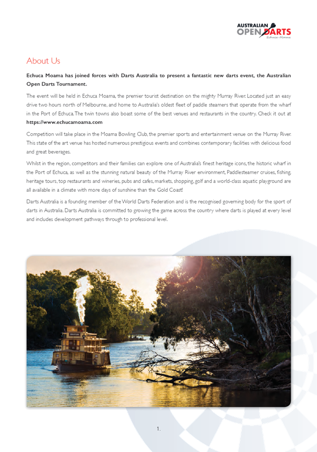
Murray River Council has signed a three year agreement with
Darts Australia to host the Australian Darts Championships, the Pacific Masters
Darts Tournament and the Australian Open Darts Tournament in Echuca Moama
during August 2019 - 2021.
Discussion
It has now been agreed that the three events will run from
29 July – 10 August 2019.
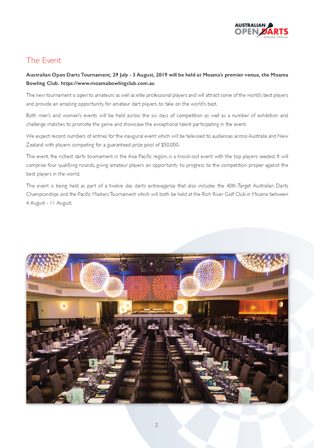
The Australian Open Darts Tournament will run from 29 July
– 3 August 2019 and consists of 4 last chance qualifier rounds followed
by the tournament proper featuring the final 32 qualifiers. It will be held at
the Moama Bowling Club.
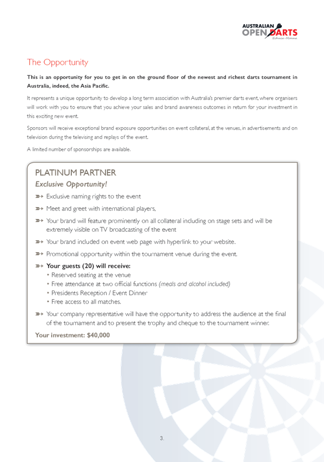
The event has attracted a great deal of interest and I can
confirm the attendance of four international players including the ladies current
world champion, Mikuru Suzuki of Japan; four times ladies world champion Lisa
Ashton from England; Jim Williams current number 3 in the world rankings from
Wales and; Scott Mitchell currently ranked number 1 in the World Darts
Federation rankings from England.
The name, Australian Darts Open, was agreed between MRC and
Darts Australia as the name for the tournament proposed by MRC.
A logo has been developed and registered as an MRC trademark
with IP Australia. This action was necessary to protect MRC’s rights and
ensure that the event will continue to be held in Echuca Moama beyond the
initial three year term.
To provide security and certainty to Darts Australia that
the event will be affiliated with that organisation going forward, council
should enter into an affiliation agreement with Darts Australia. This agreement
will be developed over coming months and presented to council for
consideration.
Copies of the logo and example of brand documents are
attached for council’s information.
Check out the web landing page; https://www.echucamoama.com/australian-darts-open
The Pacific Masters Tournament will also feature the
international players and others from across the pacific region and will be
held at the Rich River Golf Club on 4 August 2019.
The Australian Championships will kick off on Monday 5
August and conclude on Saturday 10 August 2019.
A copy of the draft program is included as an attachment to
this report.
Accommodation bookings have been strong and steady and are
being managed by Echuca Moama Visitor Centre and Echuca Moama Accommodation
Association.
Strategic Implications
4 - Strategic Theme 4: Economic Growth
4.2 - Continue focus on strong and vibrant tourism
4.2.3 - Promote and encourage local, state and national
events
Budgetary Implications
Nil
Policy Implications
Nil
Legislative Implications
Nil
Risk Analysis
· What
can happen?
NA
· How
can it happen?
NA
· What
are the consequences of the event happening?
NA
· What
is the likelihood of the event happening?
NA
· Adequacy
of existing controls?
NA
· Treatment
options to mitigate the risk?
NA
Conclusion
The event is now being extensively advertised to the world
darts community and organisation and coordination is well underway with regular
meetings of the event organisation group which consists of representatives from
darts Australia, Murray River Council, Echuca Moama Tourism, Echuca Moama
Accommodation Association and both venues.
Further updates will be provided to council on a regular
basis.
Attachments
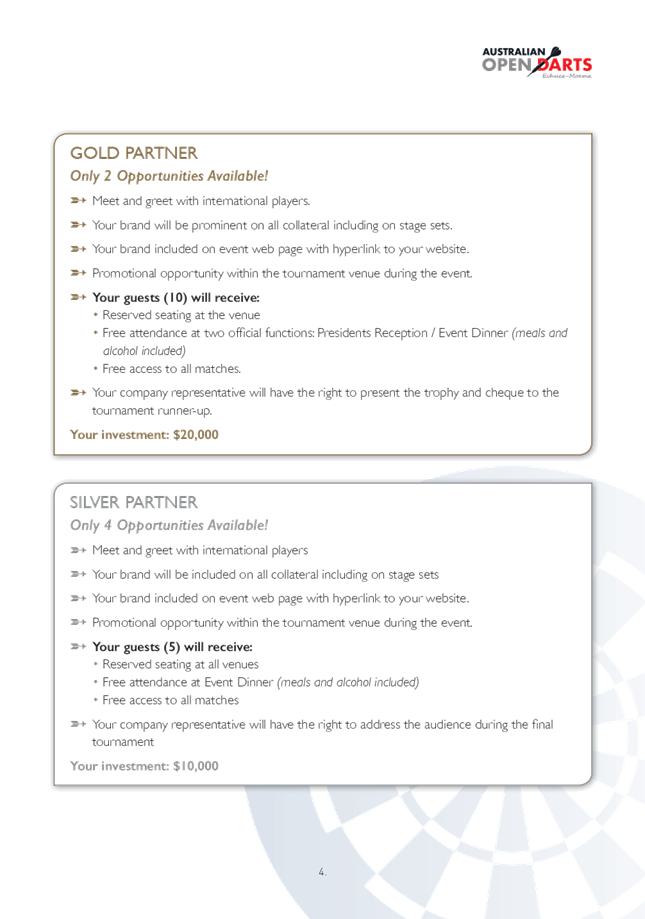
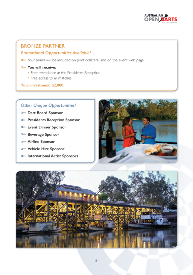
1. International
Player Profiles ⇩ 
2. Sponsorship
Proposal ⇩ 
3. Australian
Open Darts Logo (No EM) ⇩ 
4. Australian
Open Darts ⇩
5. Draft
Darts Event Program ⇩
|
Ordinary Council Meeting Agenda
|
26 February 2019
|


|
Ordinary
Council Meeting Agenda
|
26 February 2019
|


|
Ordinary
Council Meeting Agenda
|
26 February 2019
|

|
Ordinary
Council Meeting Agenda
|
26 February 2019
|

|
Ordinary
Council Meeting Agenda
|
26 February 2019
|

10.11 ZSS
& Partners Pty Ltd - Update
File
Number: -
Author: John
Harvie, Manager Economic Development & Tourism
Authoriser: Des
Bilske, General Manager
|
Recommendation
That council resolves to;
1. Terminate the two
Agreements (MOU’s) signed on 24 August 2018 between Murray River
Council and ZSS & Partners Pty Ltd in accordance with clause 8.1.2 of the
agreement.
2. Continue to work
with ZSS & Partners Pty Ltd in a non-exclusive non-binding arrangement.
|
Background
In August 2018 council resolved;
1. To
enter into a memorandum of understanding with ZSS & Partners Pty Ltd.
2. That
the memorandum of understanding will remain in force for a period of twelve
months from the date of signing and will be reviewed after six months.
3. To
provide delegated authority to the Mayor and General Manager to sign the
document and apply the Council seal.
4. To
request that a report, outlining the success or otherwise of the agreement, be
presented to Council at the monthly meeting to be held in February 2019.
In accordance with council’s resolution, this report
seeks to update council on the activities undertaken by ZSS since August 2018.
Discussion
Since August ZSS and council’s Manager Economic
Development & Tourism have met on two occasions and corresponded on a
weekly basis.
It was agreed that ZSS should concentrate on developing a
solar farm project and seeking willing investors for the project.
ZSS assembled a team to develop the project and review
suitable sites close to state electricity grid infrastructure.
A site has been identified, close to Moulamein, and
negotiations are continuing to reach agreement with the owner on terms for a
thirty year lease.
The federal government’s announcement about the
introduction of a price cap on generators is likely to affect the profitability
of the project and ZSS are re-evaluating the project model before moving
forward.
A copy of the media release is an attachment to this report.
In answer to the question ‘has ZSS & Partners
Pty Ltd delivered value to council or the Murray River region over the past six
months?’ progress has been made in relation to one of six projects
but it is unlikely that the project will be the subject of a development
application in the next six months. At this stage it is also unlikely that the
company will make any progress on the other projects contained in
council’s agreement with them.
Strategic Implications
4 - Strategic Theme 4: Economic Growth
4.1 - Encourage and support economic development across a
range of sectors
4.1.3 - Identify new opportunities and actively encourage
investment in agriculture, agribusiness, value added manufacturing, alternate
and renewable energy, health, wellbeing, aged care, and education
Budgetary Implications
Nil
Policy Implications
Nil
Legislative Implications
Nil
Risk Analysis
· What
can happen?
Nil
· How
can it happen?
NA
· What
are the consequences of the event happening?
NA
· What
is the likelihood of the event happening?
NA
· Adequacy
of existing controls?
NA
· Treatment
options to mitigate the risk?
NA
Conclusion
The agreements between council and ZSS & Partners Pty
Ltd gives the company exclusive rights to develop and market the identified
projects. This arrangement has not yielded any results in six months and is
unlikely to produce any significant outcomes in the next six months.
In six months
Attachments
1. Media
Release - Driving down prices - Confidential
11 Director
Corporate Services Report & Supplementary Matters
11.1 Corporate
Services Update
File
Number: -
Author: Ross
Mallett, Director Corporate Services
Authoriser: Ross
Mallett, Director Corporate Services
Discussion
Work Health & Safety
No significant safety incidents occurred during the month.
Patrick Armstrong was appointed the new Safety and Risk
Officer. Patrick has extensive experience in WH&S gained in the resources
industry.
Finance
Finance has been engaged in preparing the 2018/19 December
quarter Budget review (refer separate paper) and preparations for the 2019/20
Budget.
An Audit Management Letter has been received from Crowe
Horwath in respect of the Audit for the year ended 30 June 2018. Management
responses have been completed in relation to issues raised and returned to the
auditors.
A new Management Accountant Stephen Hart has been appointed.
Stephen formerly was an accountant in the mining industry and comes to us with
a wealth of experience in management accounting.
Work has progressed on the internal audit plan projects
covering remuneration and procurement, tender and purchasing.
Corporate Services are working with Engineering to progress
the project covering assessment of the condition and value of our
transportation assets.
Human Resources
For the month of January there were:
· 2 resignations
– Risk Officer and Procurement Manager
· 3 new appointments
– Safety & Risk Officer, Manager Waste and Environmental Services and
Town Planner
· 1 replacement
appointment – Administration Officer – Corporate Services &
Engineering at Moulamein*
ICT
The NBN connection in Moama has been completed and the
existing service has experienced improved performance.
Rollout of the new telephone system has commenced and is in
testing phase in Moama.
The ICT strategy project has progressed with most senior
managers being interviewed and with workshops set out at various council
offices over the next month.
Further training in Infocouncil and LGHub has been scheduled
over the next month.
Attachments
Nil
11.2 2019/2020
Budget Timetable and Public Notice
File
Number: -
Author: Ross
Mallett, Director Corporate Services
Authoriser: Ross
Mallett, Director Corporate Services
|
Recommendation
That Council approve the draft 2019/20 Budget timetable
and Public Notice.
|
Background
Council’s Finance Department are in the process of
preparing the 2019/20 Budget Process and need to lock in on a timetable for the
key milestones in the budget process. Council also needs to issue a public
notice seeking public engagement on items to be included in the budget.
Discussion
Council are requested to review the draft timetable and
public notice and if appropriate to approve those documents.
Strategic Implications
5 - Strategic Theme 5: Leadership and Governance
5.1 - An effective, efficient and progressive Council that
provides leadership to the community
5.1.2 - Council acts in a financially responsible manner to
ensure delivery of safe and sustainable services to the community
Budgetary Implications
Not applicable.
Policy Implications
Nil.
Legislative Implications
Local Government Act 1993.
Risk Analysis
· What
can happen? If a budget is not completed on time there is a risk that
council costs will not be effectively managed
· How
can it happen? By not completing the budget on time or receiving input from
community members
· What
are the consequences of the event happening? Inability to effectively
manage council’s costs
· What
is the likelihood of the event happening? Unlikely if the budget process is
observed
· Adequacy
of existing controls? Adequate
· Treatment
options to mitigate the risk? Ensure a proper budget process is implemented
Conclusion
That Council approve the budget timetable and issuing of the
public notice to assist with the initiation of the 2019/20 budget process.
Attachments
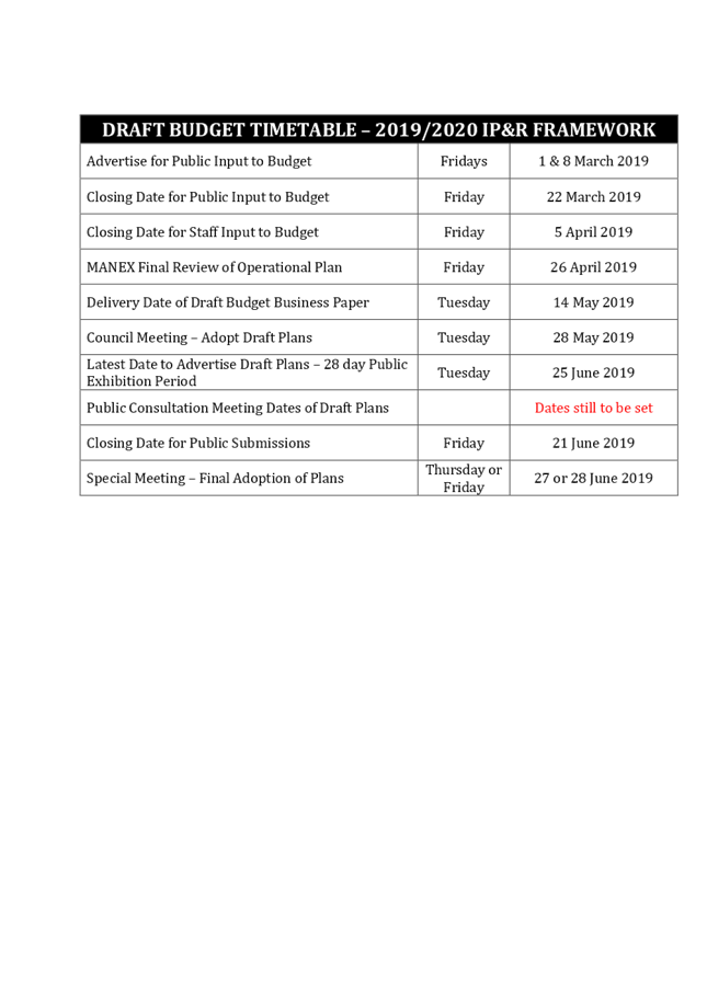
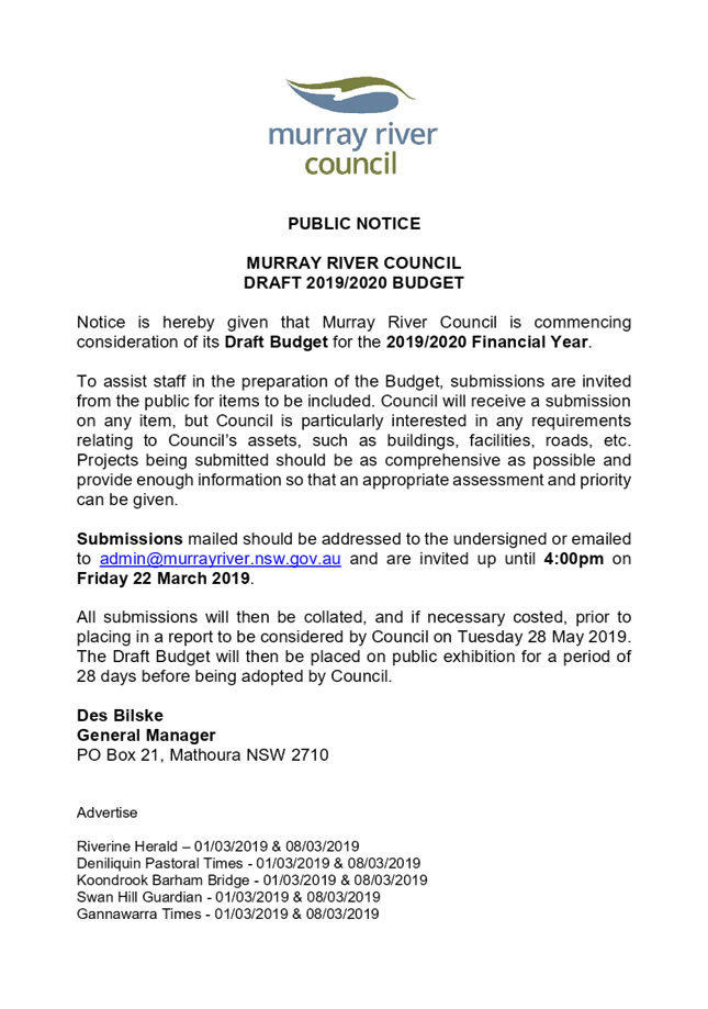
1. 2019-20
Budget Timetable ⇩ 
2. 2019-20
Budget Public Notice ⇩
|
Ordinary Council Meeting Agenda
|
26 February 2019
|
|
Ordinary Council Meeting Agenda
|
26 February 2019
|
11.3 FINANCIAL
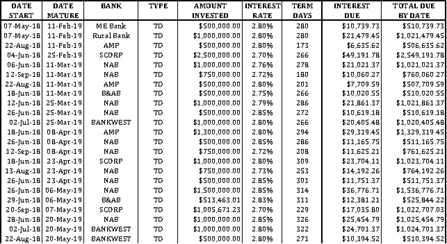
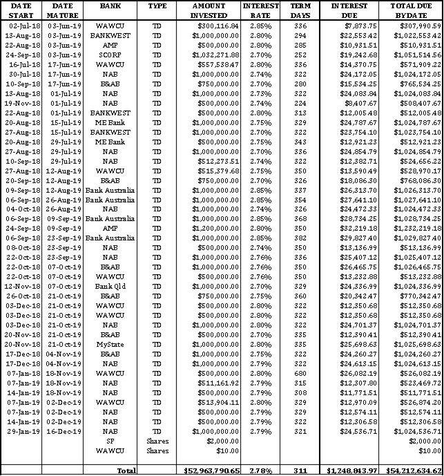
STATEMENTS & INVESTMENTS AS AT
31 JANUARY 2019
File
Number: -
Author: Anwarul
Abedin, Manager Finance
Authoriser: Ross
Mallett, Director Corporate Services
Recommendation
1. That
the report detailing Council’s cashbook balance of $56,044,413.32 as at
31st January 2019 is received.
2. That
the report detailing Council’s investment balance of $52,963,790.65 as at
31st January 2019 is received.
REPORT - BANK RECONCILIATION
Shown below are the Financial Statements, Bank Reconciliations
and Investments for the period ending 31st January 2019.
INTERIM STATEMENT OF BANK BALANCES AS AT 31st
JANUARY 2019 OF COUNCIL’S COMBINED ACCOUNTS

INTERIM
INTERNAL CASHBOOK BALANCES

OVERDRAFT LIMITS: Bank Overdraft - $650,000.00.
I hereby certify that the cashbook of the various funds of
Council has been reconciled, with the appropriate Pass Sheets as at 31st
January 2019.
Ross Mallett
Responsible Accounting Officer
REPORT - INVESTMENTS AS AT 31st
JANUARY 2019
As required by Section 212 of the Local Government
(General) Regulation 2005 and Section 625 of the Local Government Act 1993, the
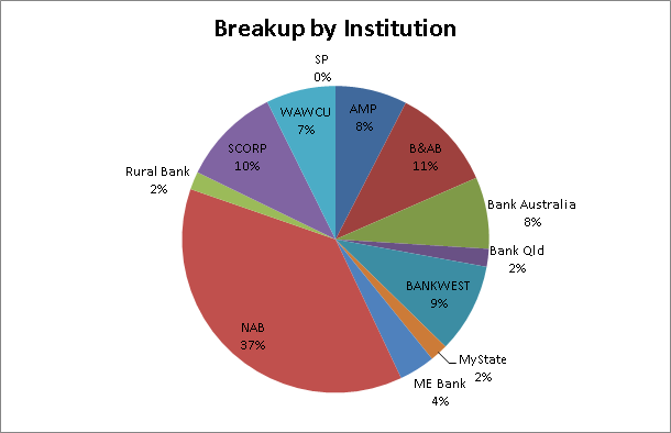
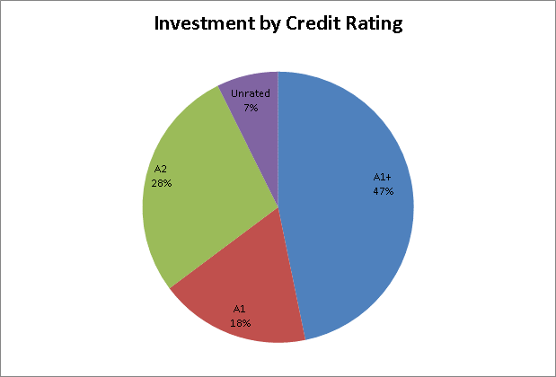
details of Council’s surplus funds invested, totalling $52,963,790.65 are
listed below:
STRATEGIC IMPLICATIONS:
Nil
BUDGETARY IMPLICATIONS:
Current low interest rates may reduce the expected
interest revenue.
POLICY IMPLICATIONS:
Investments have been made in accordance with the
Council Investment Policy which was adopted on the 17th October
2017.
LEGISLATIVE IMPLICATIONS:
Section 625 of the Local Government Act 1993
Regulation 212 of the Local Government (General)
Regulations 2005
Trustees Act 1925 Section 14
RISK ANALYSIS:
Under the Council’s Investment Policy,
investments are made with a range of banks or financial institutions, with
Council’s funds invested with a single institution have not gone above
the maximum amount as specified in the Policy.
CONCLUSION:
Murray River Council’s liquidity is in a
satisfactory position at 31st January 2019.
Attachments
Nil
11.4 Rationalisation
of Council Housing
File
Number: -
Author: Ross
Mallett, Director Corporate Services
Authoriser: Ross
Mallett, Director Corporate Services
|
Recommendation
That Council authorise the General Manager to sell council
properties located at 38 Linton Park Drive, Barham and 26 Turora Street,
Moulamein being properties in excess of council’s requirements.
|
Background
Council owns and maintains 6
properties in Moulamein and one in Barham for the following purposes:
· To provide
overnight and short-term accommodation to council manager, staff and approved
external parties (eg auditors) traveling to Moulamein and Barham; and
· To provide
longer-term accommodation to approved managers and key staff as an incentive to
relocate and reside in Moulamein where access to housing is limited.
|
Property Address
|
Purpose of house
|
Current Resident
|
Retention/Disposal
|
|
31 Gwynne Street,
Moulamein
|
Overnight or short-term accommodation
|
New Management Accountant undergoing induction
|
Well used - Retain
|
|
38 Linton Park Drive,
Barham
|
Overnight or short-term Accommodation
|
Nil
|
Dispose due to low usage and high maintenance cost
|
|
44 Nyag Street,
Moulamein
|
Long-term accommodation for manager/staff
|
Manager
|
Retain
|
|
37 Turora Street,
Moulamein
|
Long-term accommodation for manager/staff
|
Staff member
|
Retain
|
|
7 Tualka Terrace,
Moulamein
|
Long-term accommodation for manager/staff
|
Staff member
|
Retain
|
|
20 Carne Street,
Moulamein
|
Long-term accommodation for manager/staff
|
Staff member
|
Retain
|
|
26 Turora Street,
Moulamein
|
Long-term accommodation for manager/staff
|
Staff member
|
Dispose as staff member leaving and property is surplus to
Council needs
|
Discussion
Moulamein has limited rental accommodation available for
staff and motel accommodation for council visitors and accordingly council in
the past has made available council housing to attract and retain managers and
key staff to the region. However, council management is of the view that the
costs of holding and maintaining six houses in Moulamein outweighs the benefit
and is recommending that one of the properties be placed on the market for
sale. As one of the staff tenants will be leaving council at the end of March
the departure provides an opportunity to sell the property rather than
retaining it in case a need arises to make it available to other staff.
Management believes that the balance of council housing
available in Moulamein is sufficient to meet council needs in the near future.
The property in Barham differs from the Moulamein properties
in that it is held for short-term/overnight accommodation, is not well used and
there are a number of motels locally that provide alternate accommodation. The
property also attracts high maintenance costs of around $580 per month that are
disproportionate to the benefit of the accommodation provided.
Strategic Implications
5 - Strategic Theme 5: Leadership and Governance
5.1 - An effective, efficient and progressive Council that
provides leadership to the community
5.1.2 - Council acts in a financially responsible manner to
ensure delivery of safe and sustainable services to the community
Budgetary Implications
The sale and reduced maintenance costs would lead to further
funds being available to be allocated to high priority projects
The recommendation is consistent with Council policy
Policy Implications
The recommendation is consistent with existing Council
policy
Legislative Implications
Nil
Risk Analysis
· What
can happen?
A demand may arise for
accommodation in Moulamein in excess of council housing availability
· How
can it happen?
· Due
to multiple visitors to Moulamein at the same time.
· What
are the consequences of the event happening?
· Some
of the visitors would need to seek alternate accommodation in Moulamein, Swan
Hill or Barham
· What
is the likelihood of the event happening?
low
· Adequacy
of existing controls?
Adequate
· Treatment
options to mitigate the risk?
· Council
will work with the visitors to source alternate accommodation
Conclusion
The current number of council houses is excessive and the
sale of one property in each of Moulamein and Barham would improve utilisation
of the assets and allow surplus resources to be transferred to areas of higher
priority
Attachments
Nil
11.5 DECEMBER
2018 QUARTERLY BUDGET REVIEW
File
Number: -
Author: Anwarul
Abedin, Manager Finance
Authoriser: Ross
Mallett, Director Corporate Services
|
Recommendation
1. That the report on the
Quarterly Budget Review be received and noted.
2. That the budget variations as
detailed within the report be included in Council’s estimates of income
and expenditure for 2018/2019
|
Background
Clause 203 of the Local Government
(General) Regulation 2005 (the Regulations) requires a Council’s
responsible accounting officer to prepare and submit a quarterly budget review
statement to the governing body of Council. The quarterly budget review statement
must show, by reference to the estimated income and expenditure that is set out
in the operational plan adopted by council for the relevant year, a revised
estimate of income and expenditure for that year.
It also requires the budget review
statement to include a report by the responsible accounting officer as to
whether or not they consider the statement indicates council to be in a
satisfactory financial position (with regard to its original budget) and if
not, to include recommendations for remedial action.
Legislative requirements together
with the implementation of a formal reporting mechanism will ensure that
councils have a robust and transparent budget reporting framework.
Discussion
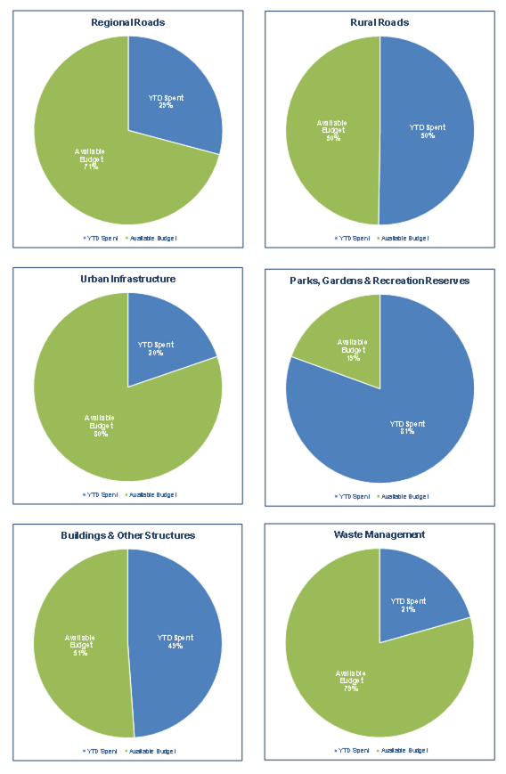
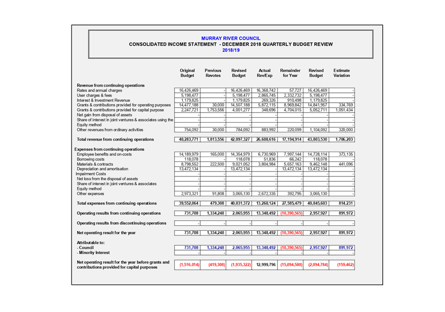
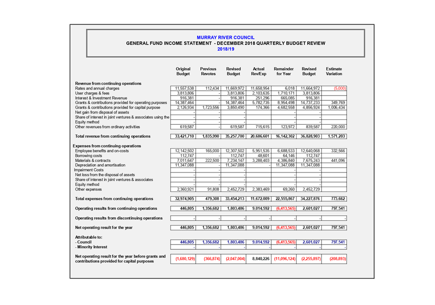
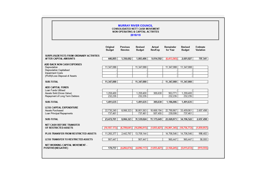
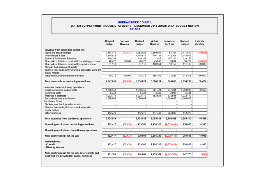
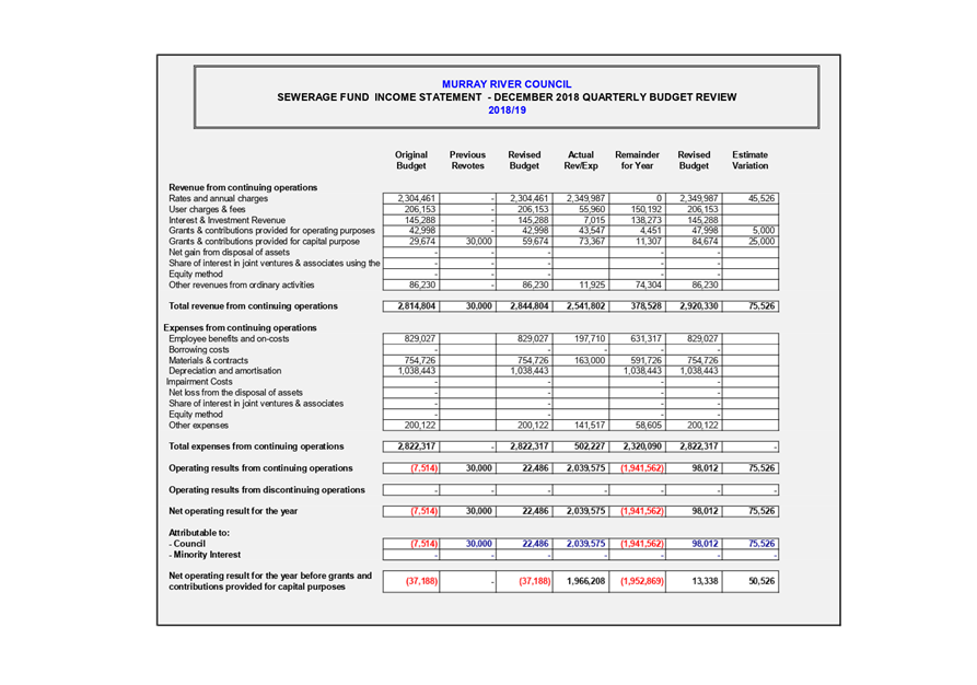
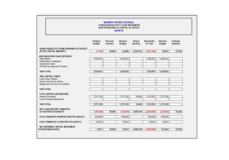
 INCOME
STATEMENT – CONSOLIDATED
INCOME
STATEMENT – CONSOLIDATED
The income statement quarterly
movements show the December 2018 quarterly review has changed the estimated
operating surplus of $2,065,955 to $2,957,927. The main reason for this change
is to include the Bridge Replacement Grant and the projects in the current
year’s budget.
Legend:
Positive Impact é ê
Negative Impact êé
Operating Revenues
Estimated operating revenue has
increased by $1,706,203 to $43,803,530.The movements are as following:
Ø Grants & Contributions
provided for Capital purposes– é $1,051,434
This has mainly increased due to
the funding we received to replace two bridges.
· Merran Creek
Bridge – é
$399,900
· Barbers Creek
Bridge - é
$394,400
· Gee Gee Bridge
Approach é
$243,390
· RFS Fire Shed é $75,000
· Developer
Contribution é $25,000
· RMS Traffic
Facilities ê $80,000
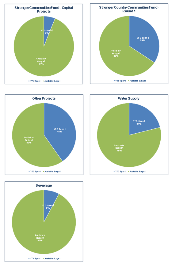
Ø Grants & Contributions
provided for Operating purposes– é $334,769
·  Levee Audit é
$109,207
Levee Audit é
$109,207
· Flood Study é $97,674
· Management of
Crown Reserve é
$92,888
· Heritage Near Me é $30,000
Ø Other Revenue– é $320,000
· Insurance
claims/rebate é
$220,000
Operating Expenses
Estimated operating expenses have
increased by $843,480 to $40,845,603
The movements are as following:
Ø Employee Benefits & On-costs
– é $373,135
·  This
is due to creating new positions which were not included in the original
budget. This is principally due to the additional staff hired for
Planning & Development Services.
This
is due to creating new positions which were not included in the original
budget. This is principally due to the additional staff hired for
Planning & Development Services.
Ø Materials & Contracts –
é $441,096
· Levee Audit é $109,207
· Flood Studyé
$97,674
· Management of
Crown Reserveé $92,888
· Heritage Near Me é $30,000
· Waste Energy
Feasibility Study é
$15,00
· Community Grants
Program é $8,693
NON-OPERATING
& CAPITAL ACTIVITIES – CONSOLIDATED
The main reasons for quarterly
movements are as follows:-
Ø Infrastructure assets expenditure
increased due to change of capital work program as following é $2,577,498
This has mainly increased due to
include two Bridges and Carry Over work in Current year budget.
· Merran Creek
Bridge é $801,160
· Barbers Creek Bridge
é $821,982
· Carry Over Work
from previous year é
$573,205
· Gee Gee Bridge
Approach é $243,390
· Carry Over Flood
Worké $183,067
· RFS Fire Shed é
$75,000
· School Crossing ê
$160,000

ALL
FUNDS STATEMENT
The following statement is made in
accordance with Clause 203(2) of the Local Government (General) Regulations
2005.
It is in my opinion that the Quarterly
Budget Review Statement for Murray River Council for quarter ended 31/12/2018
indicates that Council’s projected financial position at 30/06/19 will be
satisfactory / unsatisfactory at year end, having regard to the
projected estimates of income and expenditure and the original budgeted income
and expenditure.
Signed:  Date: 19th Feb 2019
Name: Ross Mallett
Responsible Accounting Officer,
Murray River Council
Strategic Implications
5 - Strategic Theme 5: Leadership and Governance
5.1 - An effective, efficient and progressive Council that
provides leadership to the community
5.1.1 - Council decision making takes into account the needs
and priorities of our local communities and the longer term social, cultural,
economic and environmental viability and sustainability of our region
Budgetary Implications
All the additional expenditure will be funded through
combination of grant income, internal reserve, external reserve and unrestricted
funds
Policy Implications
Nil
Legislative Implications
Nil
Risk Analysis
· What
can happen?
Nil
· How
can it happen?
Nil
· What
are the consequences of the event happening?
Nil
· What
is the likelihood of the event happening?
Nil
· Adequacy
of existing controls?
Nil
· Treatment
options to mitigate the risk?
Nil
Conclusion
Murray River Council budget is satisfactory end of the
December 2018 quarter
Attachments
1. Budget
Review Appendix 1 ⇩
2. Budget
Review addendum Appendix 2 ⇩
|
Ordinary Council Meeting Agenda
|
26 February 2019
|


|
Ordinary
Council Meeting Agenda
|
26 February 2019
|

12 Director
Engineering Report & Supplementary Matters
12.1 STRONGER
COUNTRY COMMUNITIES FUND - MOULAMEIN SWIMMING POOL PROJECT
File
Number: -
Author: Scott
Barber, Director Engineering
Authoriser: Scott
Barber, Director Engineering
|
Recommendation
That Council
1. note
the $14,097.33 variation to the Moulamein Swimming Pool Project;
2. authorise
the additional funds to be sourced from general reserves.
|
Background
Council received funding of $133,975 (excluding GST) under
the NSW Government Stronger Country Communities Program Round 1 for Moulamein
Pool Project. The deadline for completion of the project is 30 April 2019.
Council posted the Request for Quotations (RFQ) on Tenderlink
in November 2018. The RFQ closed on 13 December 2018. Quotations were received
from TP Aquatic Constructions Pty Ltd ($1,464,375 including GST) for a new
concrete pool and Naughtons Pools Pty Ltd ($145 050 including GST) for fibre
glass lining of the pool. On 8 January 2019, Council awarded Naughtons Pools
Pty Ltd a contract to undertake the relining of Moulamein Swimming Pool and
associated works for a sum of $145,050 (including GST).
Discussion
On 9 January 2019, after discussion with Polytherm Pty Ltd,
its subcontractor for fibre glass lining installation, Naughtons Pools Pty Ltd
advised that they price had omitted the cost for sandblasting the existing pool
lining. A site inspection on 14 January 2019 by a Polytherm Pty Ltd representative
and Mr Justin Hatfield of Naughtons Pools Pty Ltd, confirmed that sandblasting
is essential for preparing the existing surface for the fibreglass to
bond. Naughtons Pools Pty Ltd advised that they do not have the capacity
to absorb the cost of sandblasting within the agreed contract
price.
On 24 January 2019 Naughtons Pools Pty Ltd proposed a
revised contract sum of $157,380, increasing the contract sum by $12,330
(including GST). The Project Manager’s assessment is that Naughtons Pools
Pty Ltd appears to be genuine and acting in good faith in its representations
to Council.
Options:
1. Reject
the proposal by Naughtons and seek new tenders. During the RFQ process, Council
issued RFT documents out to 14 prospective suppliers and received two
quotations only. The 14 inquiries received indicate a good outreach. They
demonstrate market’s awareness of the opportunity. Readvertising the
tender will not likely generate additional interest. Had Council embarked on a
new tender process, the funding deadline will have been missed, which is not
likely to be extended anyway by NSW Department of Industry. As a result,
Council stood to lose the grant.
2. Accept
the proposal.
Despite the time constraints, the Project Manger’s
evaluation is that the proposed revised contract price $157,380 is still
excellent value for money. Varying the Naughtons Pools Pty Ltd contract
is in Council’s best interest.
Strategic Implications
1 - Strategic Theme 1: Built/Physical Environment
1.3 - Improve and maintain community infrastructure
1.3.3 - Provide public facilities suitable for residential
and visitor use (toilets, community halls)
Budgetary Implications
The Funding Deed for the Stronger Country Communities Fund
(Round 1), allocates the grants strictly by Project e.g. Moulamein Pool
Project. Funds are not transferrable between projects. Savings from projects
delivered below budget must be returned. Projects exceeding grant allocation
are ineligible for additional grant funding.
Approval was recommended to the Director Engineering and
then the General Manager that funding be sourced from Council reserves.
The proposed new project budget is summarised below
(excluding GST):
Grant
(Current Budget) $133,975.00
Proposed
Contract Variation $
9 099.73
Contingency $
5,000.00
Proposed
revised budget $148,074.73
A budget increase of $14,097.73 (excluding GST) was
approved.
Policy Implications
Nil
Legislative Implications
Nil
Risk Analysis
· What
can happen? Perceptions about the tender process.
· How
can it happen? Audit finding
· What
are the consequences of the event happening? Minor as the value exceeds
threshold by 5%, financially immaterial but worth noting.
· What
is the likelihood of the event happening? Low
· Adequacy
of existing controls? Adequate as the matter was brought to
management’s attention.
· Treatment
options to mitigate the risk? Ensure transparency
Conclusion
The contractor has made an unintentional error in their
quote. Including this variation, the contractors quote is still significantly
lower than the next best quote to repair the Moulamein Swimming pool.
Attachments
Nil
12.2 Murray
River Council Draft Graffiti Policy
File
Number: -
Author: Frederik
Groenewald, Manager Engineering Operations
Authoriser: Scott
Barber, Director Engineering
|
Recommendation
That Council adopt the Murray River Council Graffiti
Policy.
|
Background
It was resolved at the Ordinary Meeting of Council of 26
June 2018 that Council adopt the Murray River Council Graffiti Policy in draft
and that same be placed on public exhibition for a period of 28 days to allow
for public comment/submissions (resolution no. 260618).
Discussion
There have been no responses in relation to the advertising
of the draft Graffiti Policy.
Graffiti is writing or drawings that have been scribbled,
scratched, painted – typically illicitly – on a wall or other
surface, usually within public view. Graffiti can range from simple written
words to elaborate wall paintings. Graffiti covering public spaces can give the
impression of poor safety and increased crime. Environmentally the cost can
include polluting of waterways by chemical substances, and damage to items of
environmental significance. The removal and management of graffiti can become
costly to council and the community.
This policy seeks to address these impacts in a sensitive
and cost effective manner.
The objectives are to improve the built and physical
environment of Murray River Council by reducing the occurrence of graffiti,
removing it as quickly as possible, reducing the incidence of graffiti, and
using environmentally sustainable methods to minimise harm to the environment.
Strategic Implications
1 - Strategic Theme 1: Built/Physical Environment
1.1 - Improve and maintain our built town environments
1.1.1 - Support each township to develop their unique
character
Budgetary Implications
There are no direct budgetary implications, however an
increase in the occurrence of graffiti may require higher levels of operational
expenditure.
Policy Implications
Murray River Council Graffiti Policy (POL304).
Legislative Implications
Graffiti Control Act 2008.
Local Government Act 1993.
Protection of the Environment Operations Act 1997.
Risk Analysis
· What
can happen? Occurrences of graffiti
· How
can it happen? Criminal activity
· What
are the consequences of the event happening? Perceived poor safety in areas
of increased graffiti, increased crime
· What
is the likelihood of the event happening? Graffiti is on the rise
nationally, so the increase in incidence in this Council is likely
· Adequacy
of existing controls? Unknown. Council has linked real and perceived public
safety to the Built/Physical Environment Strategic, with an ongoing improvement
in safety including the installation of Closed Circuit Television Cameras along
Meninya Street and around the Recreation Reserve at Moama.
· Treatment
options to mitigate the risk? Adopt the Graffiti Policy.
Conclusion
Graffiti impacts the community in a number of negative ways.
This policy, when adopted, seeks to address these impacts in a sensitive and
cost effective manner.
Attachments
1. MRC
POL304.V1 DRAFT Graffiti Policy ⇩ 
|
Ordinary Council Meeting Agenda
|
26 February 2019
|
|
Ordinary Council Meeting Agenda
|
26 February 2019
|
File
Number: -
Author: Brodie
Goodsell, Manager Asset Systems
Authoriser: Scott
Barber, Director Engineering
|
Recommendation
That Murray River Council approve the Moama Mid-West
Drainage Strategy for community consultation.
|
Background
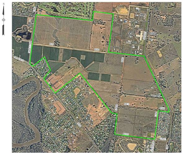
The 306ha “Moama Mid-West”
drainage catchment is made up of an urban growth corridor in the town of Moama from
the Cobb Highway west to 24 Lane and Perricoota Road north to the Rich River
Golf Club (Figure 1). The catchment was identified in the Moama North West
Master Plan (MNWMP) in 2009 as the town’s primary growth corridor and has
experienced a period development, which exceeded the projections of the 2009
Plan, and rezoning in the 10 years since the MNWP’s creation.
Figure 1: Mid-West
Drainage Study Area
As the land within the Mid-West catchment is owned by
several different landholders, several individual Development Applications (DA)
have been received by Council with discreet designs in each individual
development area (sub-catchment). These individual designs have been
created to service only the internal requirements of each of the 8
sub-catchments and have not enabled the flow of water across the catchment, the
adequate storage of stormwater for major rain events or the ultimate disposal
of captured stormwater to the Murray River. These issues have led to the
creation of the Moama Mid-West Drainage Strategy which is a detailed whole of
catchment design that specifies the stormwater requirements for each
constituent sub-catchment, a flow path design between each sub-catchment and
the ultimate disposal requirements for the entire catchment.
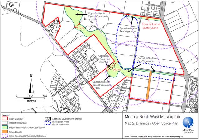
The Moama North West Master Plan (2009) earmarked an open
space corridor contained within the 94.5 (AHD) contour for the capture and
storage of stormwater as well as recreational use. The Moama Mid-West
Drainage Strategy provides the detailed stormwater design required to deliver
the multi-use component of the corridor set aside in the Moama North West
Master Plan as seen in Figure 2. 
Figure 2: Open Space
Corridor (2009)
Using the footprint specified in the MNWMP and extending the
94.5 (AHD) contour north into the proposed rezoning area north of Beer Road, the
Moama Mid-West Drainage Strategy details the design requirements,
volumes and levels to enable the management of all stormwater captured within
each sub-catchment (development area) and the linear connection of these
sub-catchments.
Figure 3: Multi-use
Corridor (2019)
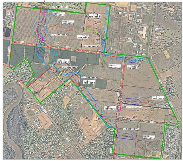

As shown in Figure 3 from the Strategy, the proposed multi-use
corridor will hold captured stormwater in a peak flow rainfall event (1%, 24
hour storm event) to protect infrastructure and public safety. When not
in use as a high level storage the area can be utilised as a green public open
space, as per MNWMP recommendations. The vegetated multi-use
corridor is designed to resemble a natural billabong system as per the MNWMP
specifications. The corridor will contain a series of 8 detention basins
which will contain areas of permanent water, combined with air space for
standard (1% in 1 hour) rainfall events. An additional vegetated overland
flow path will then be used as a public green space during dry weather and a
detention zone for extreme (1%, 24 hour) storm events. The system has
been designed to allow for the pumped disposal of the detained stormwater
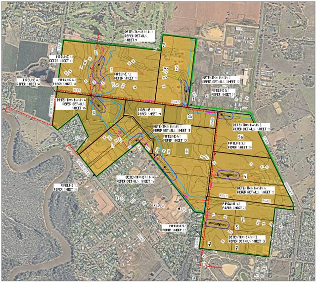
within a 24 hour period as presented in Figure 4.
Figure 4: Pumping
paths to discharge excess water from planned storage

Council is proposing the adoption of the Moama
Mid-West Drainage Strategy and the integration of the recommended design
specifications in to all forthcoming DA requirements within the
catchment. As specified in the Strategy the proposed stormwater detention
basins will enable capture and storage of standard (1% 1 hour) events with the
proposed overflow corridor allowing for storage of extreme (1% 24 hour) storm
events. The proposal will also create an attractive multi-use zone
which can be utilized for recreation and enable the water captured within the
catchment to be sustainably reused on Council green spaces.
Discussion
The Moama Mid-West Drainage Investigation Strategy is a
formalised whole of catchment plan that will remove many of the current issues
associated with ad hoc draining design in individual developments
(sub-catchments). The study has utilised the open space footprint set
aside in the Moama North West Master Plan to create a multi-use corridor that
will hold captured stormwater in an extreme (1%, 24 hour) storm event to
protect infrastructure and public safety. When not in use as a high level
storage the area can be utilised as a green public open space, as per MNWMP.
The Strategy will also need to be integrated
into Councils strategic planning documents and internal DA assessment process
via the Murray River Council Development Control Plan, Strategic Land Use Plan
and Engineering Guidelines for Subdivisions and Development Standards.
This will ensure that the document triggers under the 4.15 evaluation (former
Section 79C) of the Environmental Planning & Assessment Act 1979 (for
statutory assessment) and can be utilized by staff in the DA assessment process.
When adopted as a strategic document the Strategy will
enable complete and connected planning for stormwater across the Moama mid-west
catchment.
Note a copy of the Moama Mid-West Drainage Strategy document
was provided to Councillors during an information session held on the 19th
of February 2019.
Strategic Implications
1 - Strategic Theme 1: Built/Physical Environment
1.4 - Effectively plan for, improve and maintain water,
sewer and waste
1.4.3 - Provide environmentally sensitive storm water
collection and discharge systems appropriate to community needs
Budgetary Implications
Nil.
Policy Implications
Murray River Council Delegated Authority for the Assessment
of Development Applications Policy (POL400).
Legislative Implications
Local Government Act 1993.
Local Government (General) Regulations 2005.
Protection of the Environment Operations Act 1997.
Water Management Act 2000.
Risk Analysis
· What
can happen? Catchment wide flooding during rainfall events. Inability to
dispose of excess captured stormwater
· How
can it happen? Not having adequate stormwater detention volume for
catchment. Not having linear connection between detention basins within the
catchment
· What
are the consequences of the event happening? Risk to public safety and
amenity, Possible damage or injury, Non-compliance with legislation, Not
meeting OLG requirements, Possible loss of reputation, Possible litigation and
resulting costs, Reputational damage to Murray River Council, Reduced future
population growth in Moama
· What
is the likelihood of the event happening? Very High
· Adequacy
of existing controls? Limited
· Treatment
options to mitigate the risk? Adoption of formalised whole of catchment strategy
as proposed
Conclusion
The provision of a formalized whole of
catchment drainage strategy for the Moama Mid-West catchment is
essential. To eliminate existing development and drainage issues within
the catchment Council should adopt the Moama Mid-West Drainage Strategy as
proposed.
The Strategy should also be integrated into
Councils strategic planning documents and internal DA assessment process via
the Murray River Council Development Control Plan, Strategic Land Use Plan and Engineering
Guidelines for Subdivisions and Development Standards.
Attachments
Nil
13 Director
Planning & Environment Report & Supplementary Matters
13.1 Environmental
Services Report
File
Number: -
Author: Simon
Arkinstall, Director Planning & Environment
Authoriser: Simon
Arkinstall, Director Planning & Environment
Discussion
This report details the activities of Environmental Services
from 1 January to 31 January 2019.
Attachments
1. Applications
Determined under Delegated Authority from 1 January to 31 January 2019 ⇩
|
Ordinary Council Meeting Agenda
|
26 February 2019
|
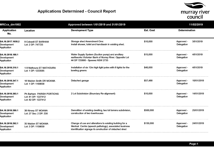
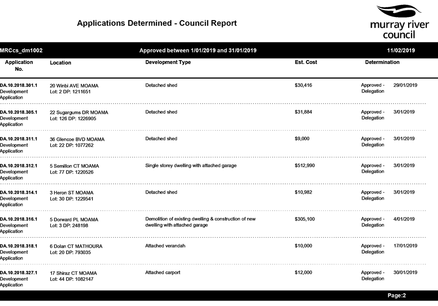
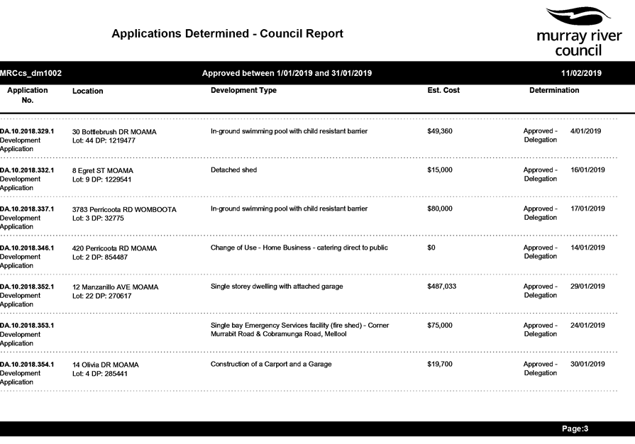
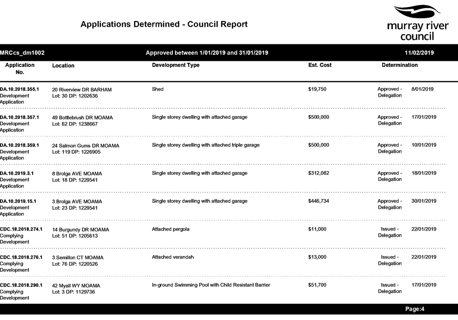
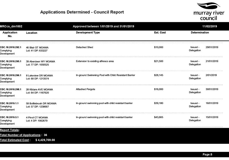
13.2 Stronger
Community Fund - Major Projects: Mensforth Park Tooleybuc
File
Number: -
Author: Simon
Arkinstall, Director Planning & Environment
Authoriser: Simon
Arkinstall, Director Planning & Environment
|
Recommendation
That Council adopt the proposed development plan for
Mensforth Park, Tooleybuc.
|
Background
Council allocated funding through the Stronger Communities Fund
– Major Projects towards the design and upgrade to Mensforth Park,
Tooleybuc.
The proposed design work has been completed through an extensive
consultation process with the Tooleybuc community and is to be utilised in the
re-development process and staff are seeking support from Council prior to
proceeding to the construction phase of the project.
Discussion
Staff engaged Liesl Malan Landscape Architects to develop a plan
for the upgrade to the open space at Tooleybuc, focusing on Mensforth Park. A
major consideration when developing the concept design related to the actual
‘build funds’ allocated to the project by Council, being
$650,000.00.
The consultants developed the plan over eight stages, which are
summarised as follows:
- Stage 1: research and
collation of data;
- Stage 2: Site visit and
investigation and meet with Council staff, Project Committee and Tooleybuc
residents. This enabled a site analysis to be complete;
- Stage 3: develop sketch
options and strategic opportunities;
- Stage 4: second trip to
Tooleybuc to workshop the designs with the Project Committee and community;
- Stage 5: re work the design
to incorporate the feedback and develop a preferred concept plan for public
display;
- Stage 6: Third trip to
Tooleybuc that incorporated a further workshop with the Project Committee and
community with respect to the proposed design and prioritise proposed works;
- Stage 7: incorporate feedback
and finalise documentation
- Develop public toilet design
and collate all research, design process and documentation.
Members of the Tooleybuc community and the Tooleybuc Piangil Action
Group were directly involved in securing funding through Murray River Council
for this project. Their input, though the Project Committee and the open public
presentations, was incorporated in all stages of the project.
Meetings with individual committee members also assisted the
consultant to understand some of the history of the region.
The final proposed plans result divided works into four distinct
stages these being:
- Playground: the aim is to
provide a terraced playground with two level play areas. The design will
incorporate nature play components along with commercial play equipment with
the entire playground being fenced.
- Bridge Keeper Cottage: the
proposed works incorporate adding a deck, arbour and outdoor kitchen.
- Public Toilets, bus stop and
car park: the proposed works will incorporate demolishing the existing
facilities and replacing same with a new modern amenities building. The
community deemed this component of the project to be of high priority.
- Flag pole and punt area:
these works focussed on improving the landscaping and connectivity of the
southern section of the park, the community did not deem this component as a
high priority.
The consultant ensured that all components of the project are to be
linked through a path network and consistent landscaping themes.
The project will be completed in a staged approach by both Council
staff and external contractors.
Strategic Implications
1 - Strategic Theme 1: Built/Physical Environment
1.1 - Improve and maintain our built town environments
1.1.1 - Support each township to develop their unique
character
Budgetary Implications
Nil impact as the proposed project is funded through the
Stronger Communities Fund and will be developed in a staged approach to ensure
the allocated budget is not exceeded.
Policy Implications
Nil implications
Legislative Implications
Nil implications
Risk Analysis
· What
can happen? Project delayed
· How
can it happen? Not endorsing the plans developed through a community
consultation process
· What
are the consequences of the event happening? Poor public perception
· What
is the likelihood of the event happening? Low
· Adequacy
of existing controls? High
· Treatment
options to mitigate the risk? Adopt proposed plans
Conclusion
Council allocated funding through the Stronger Communities Fund
– Major Projects towards the
design and upgrade to Mensforth Park, Tooleybuc.
The proposed design work has been completed through an extensive
consultation process with the Tooleybuc community and is to be utilised in the re-development
process and staff are seeking support from Council prior to proceeding to the
construction phase of the project.
Attachments
1. Tooleybuc
Final Report ⇩ 
|
Ordinary Council Meeting Agenda
|
26 February 2019
|
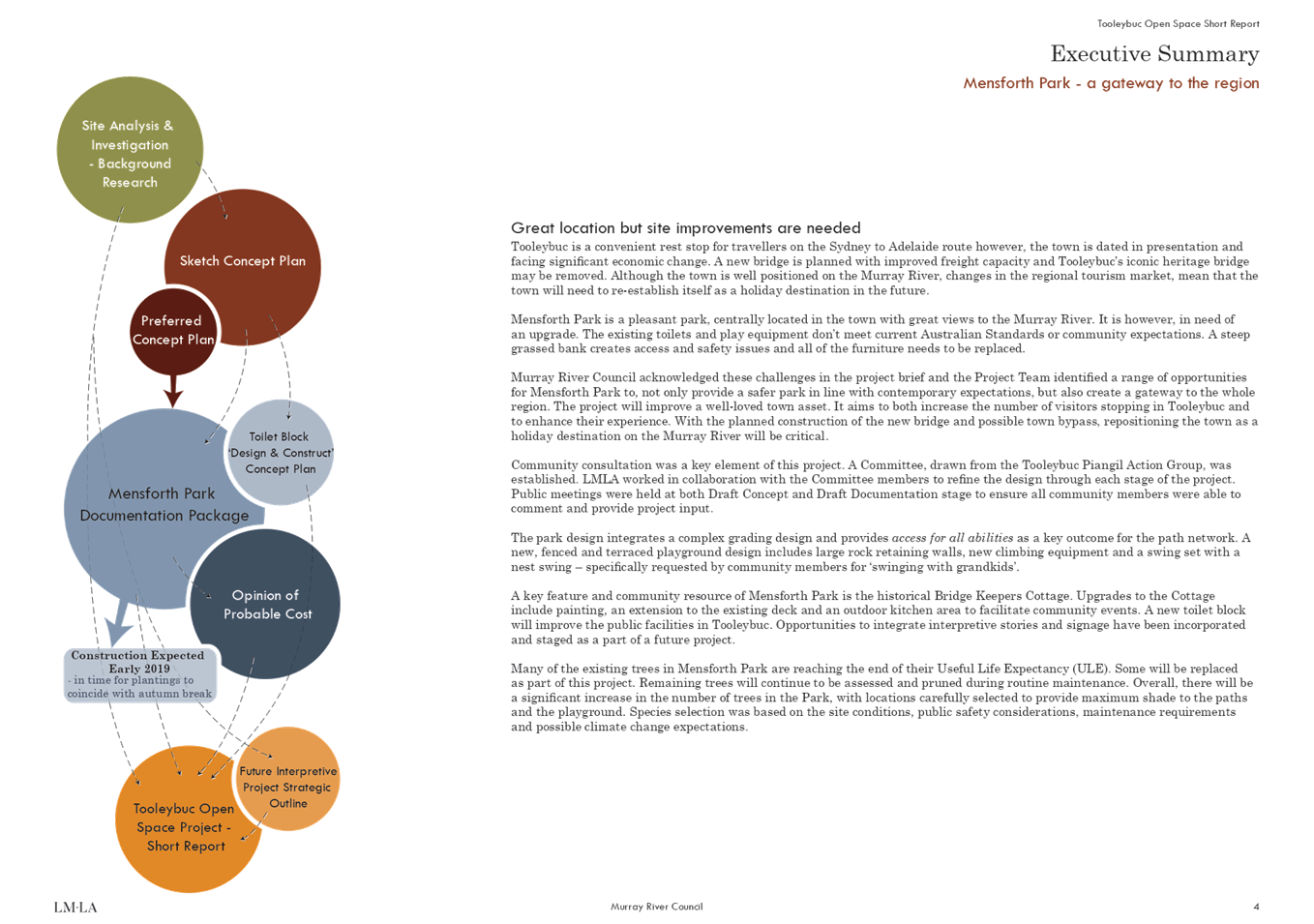
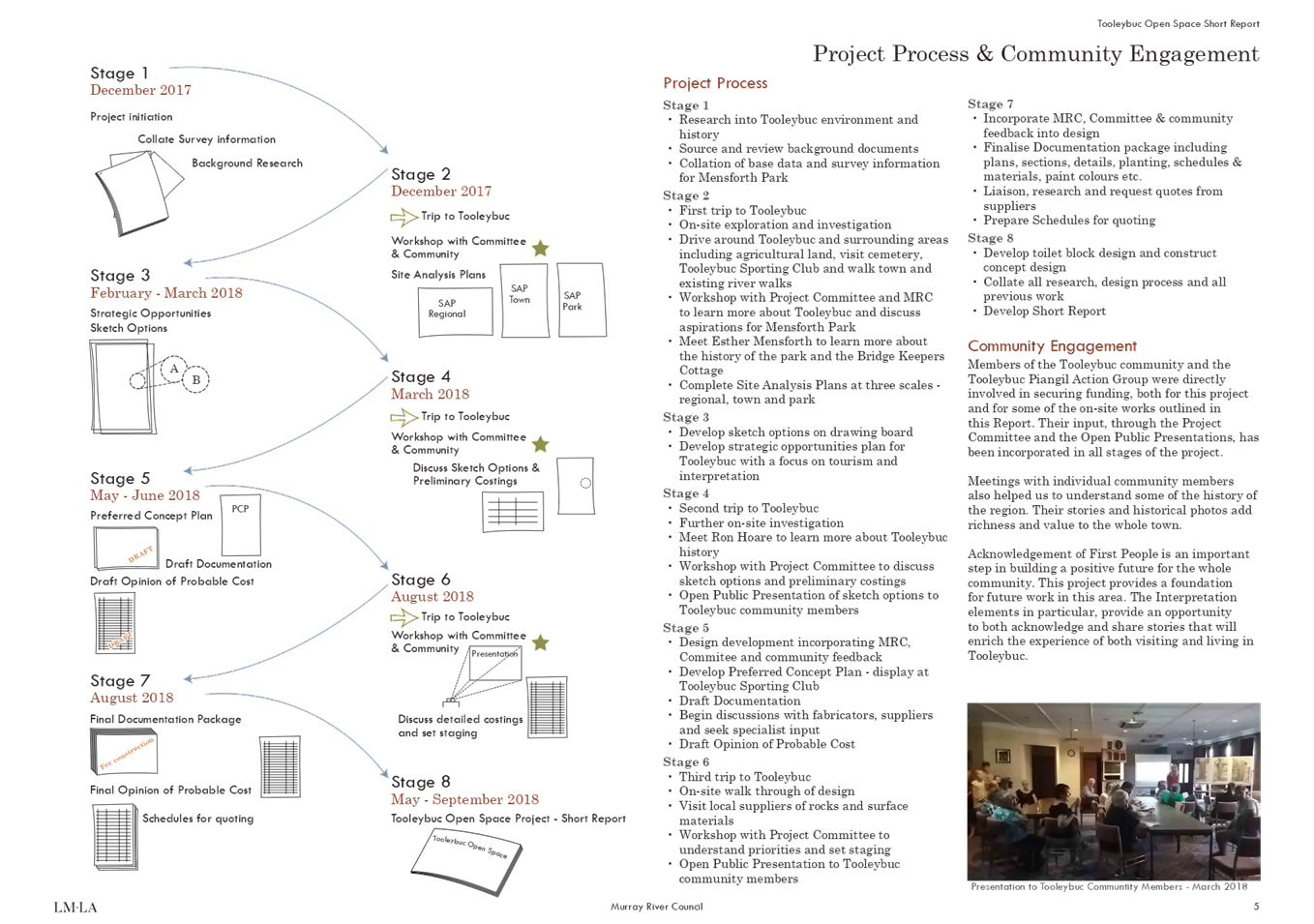
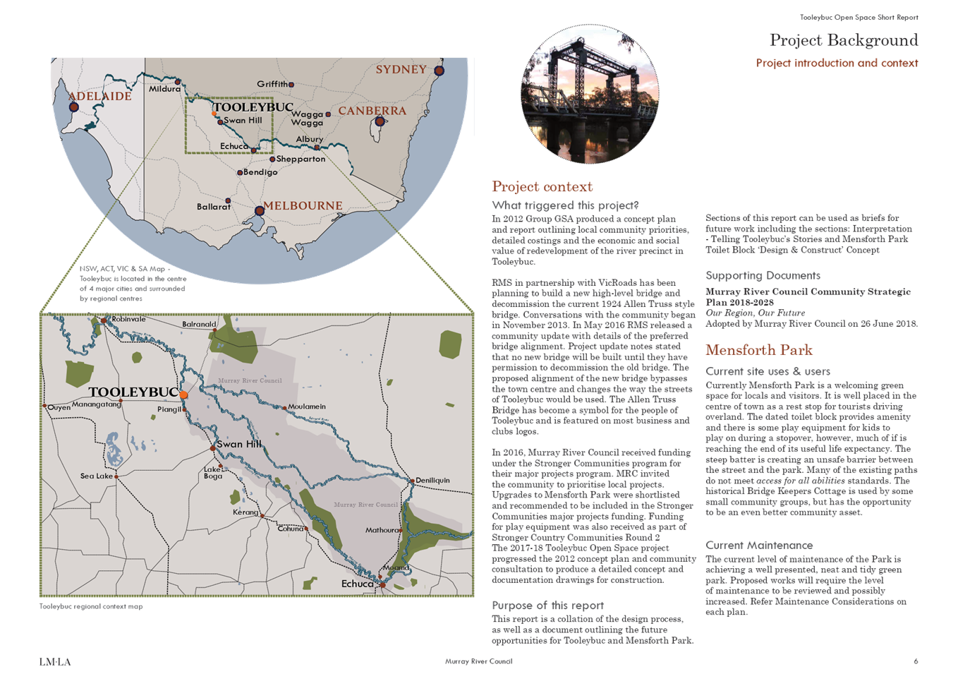
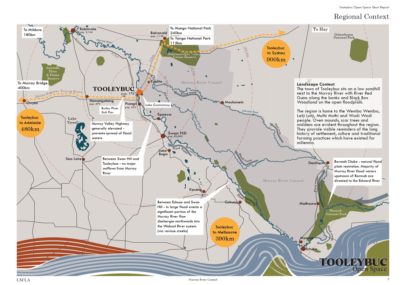
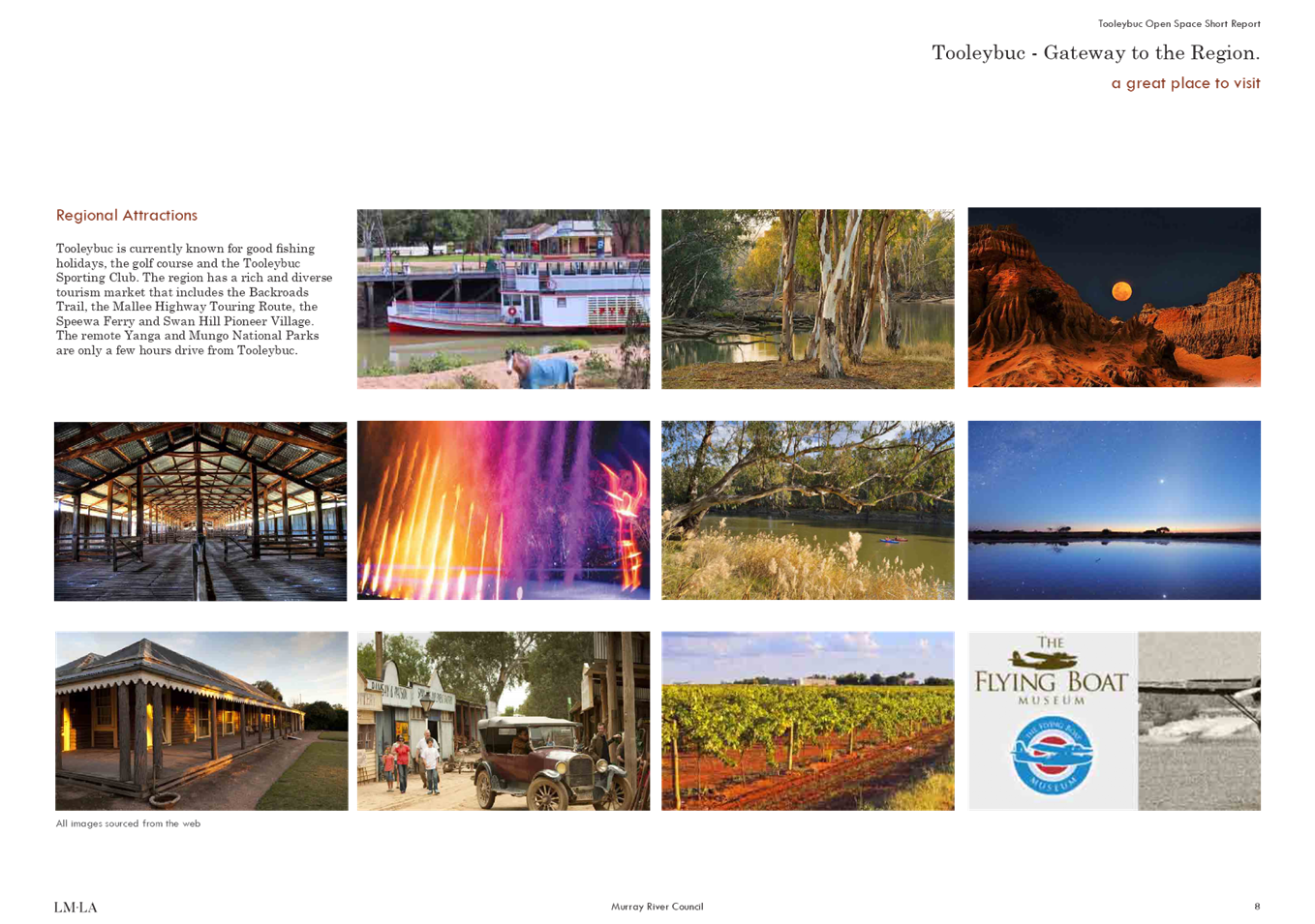
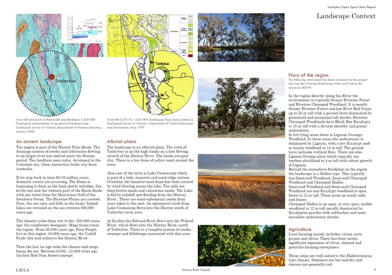
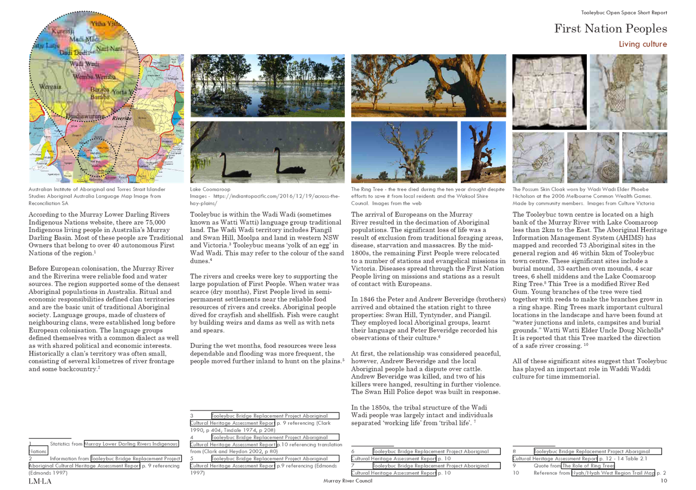
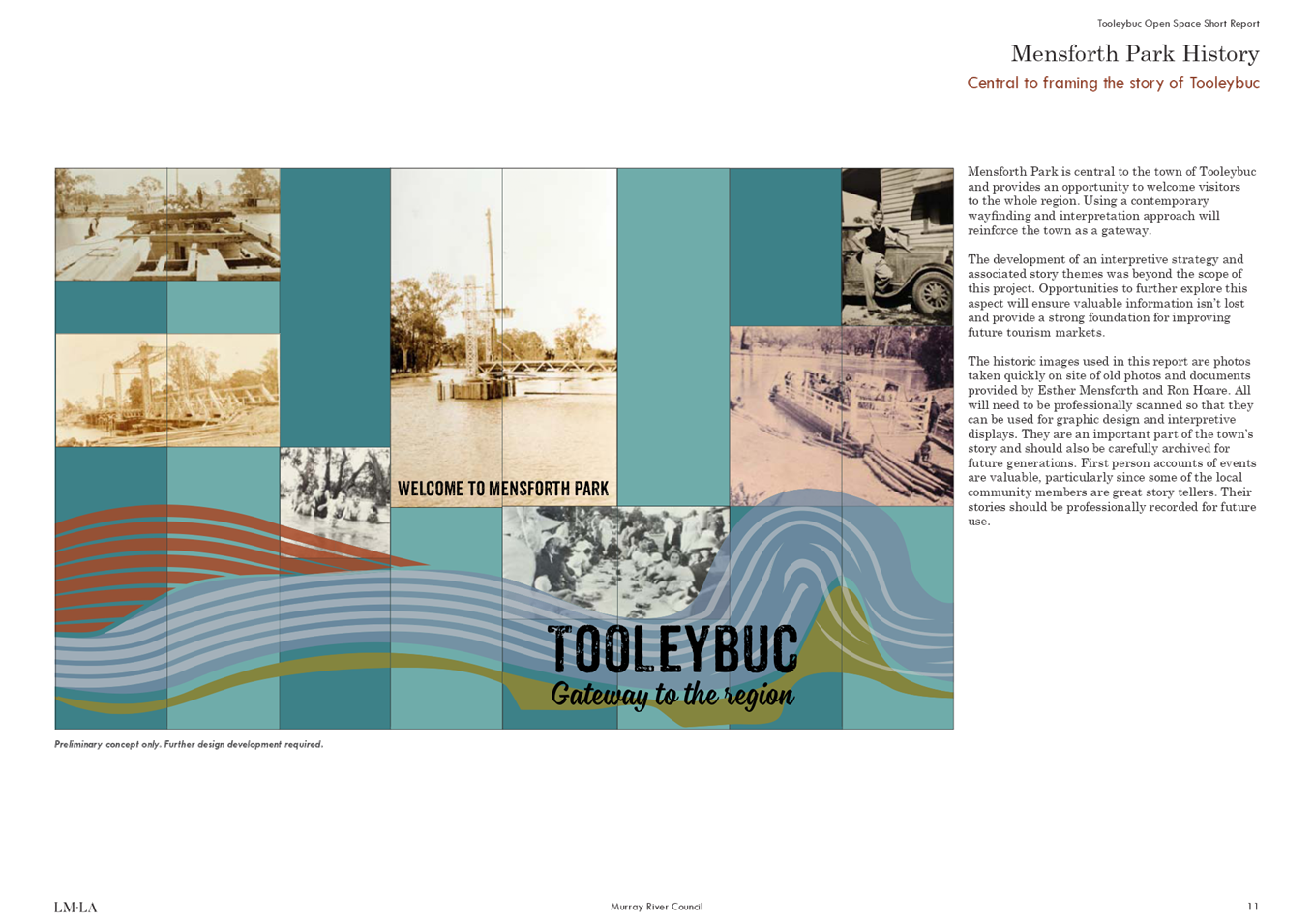
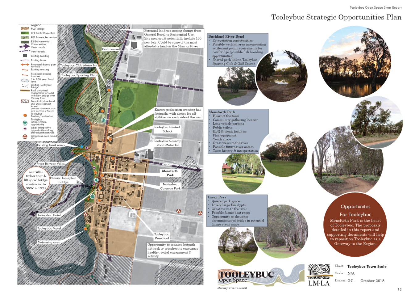
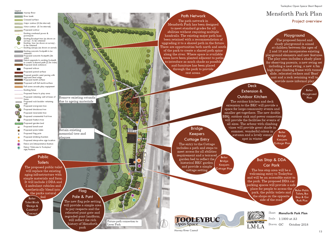
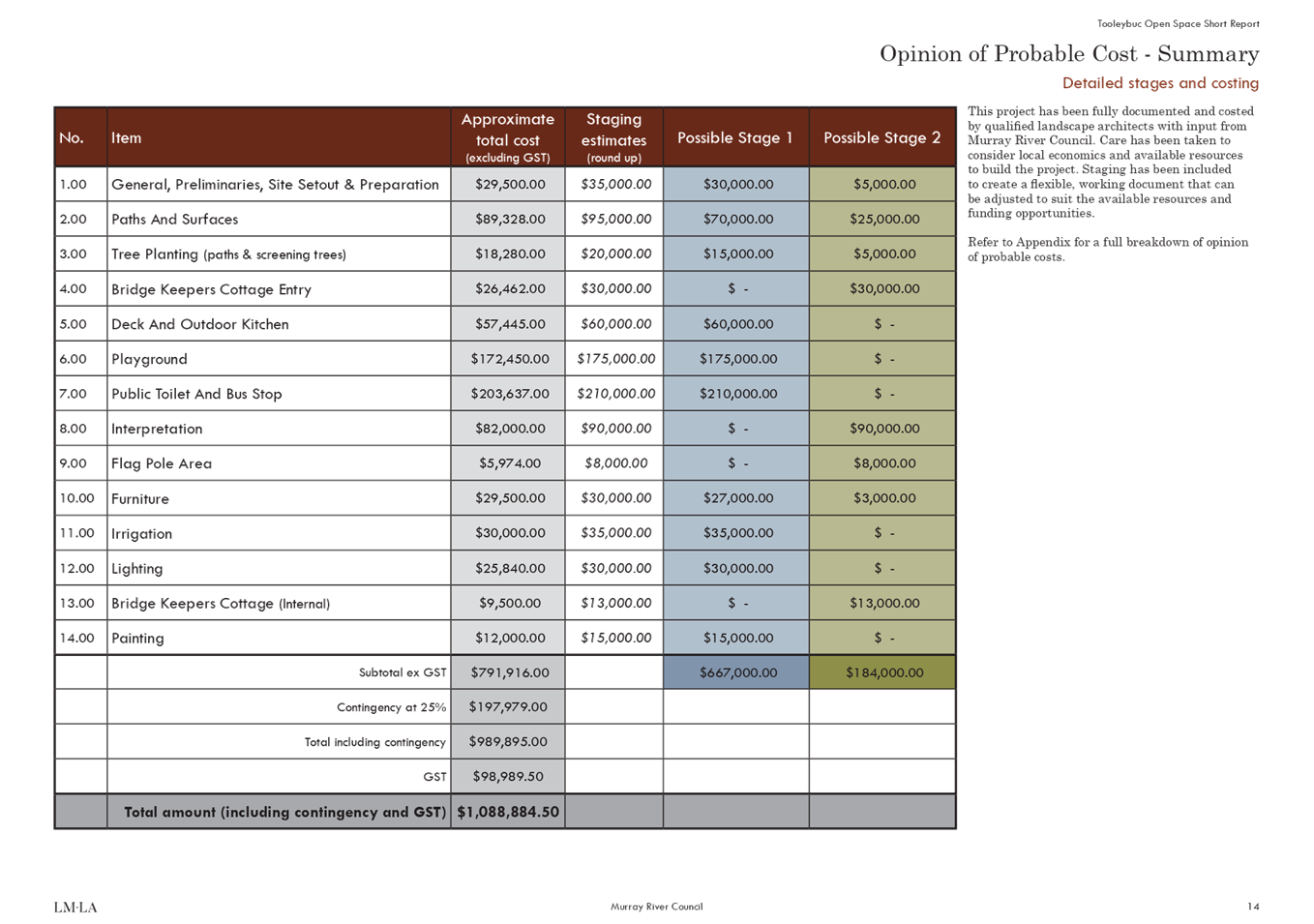
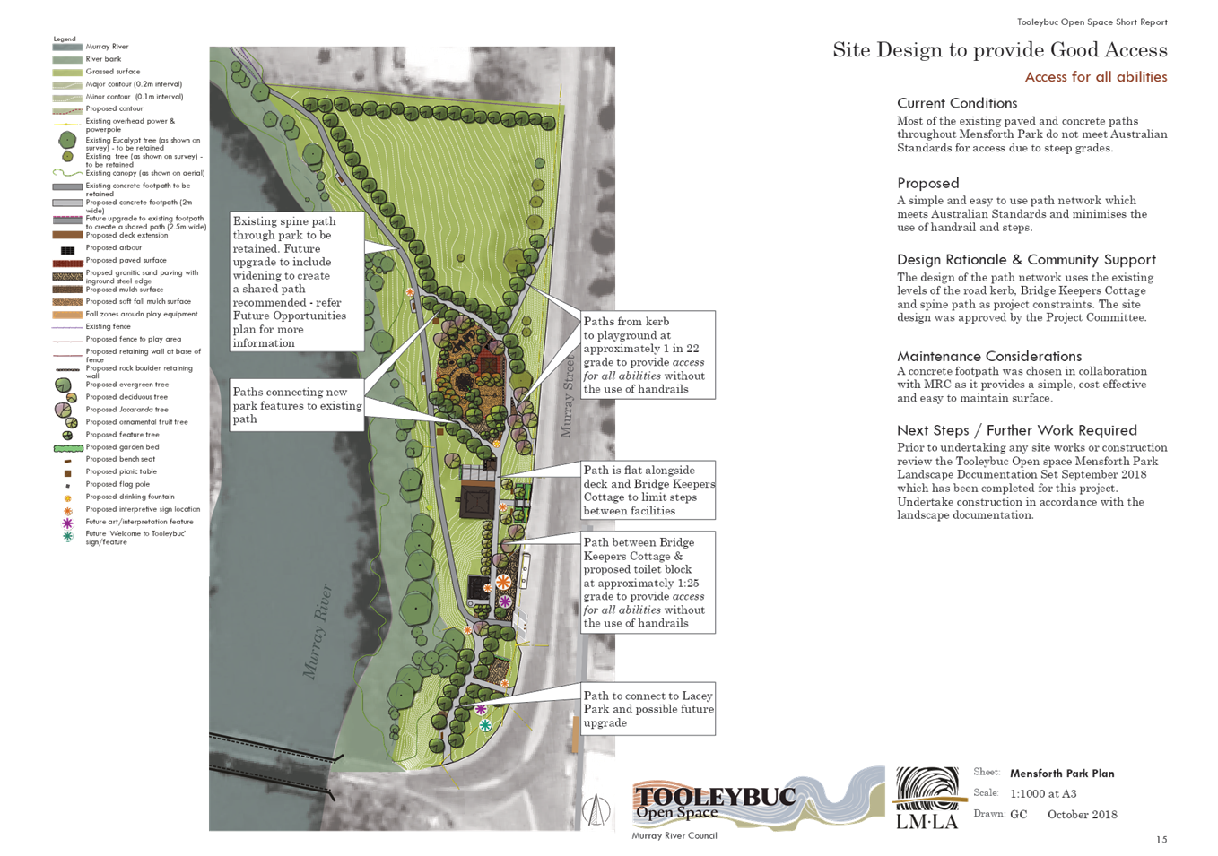
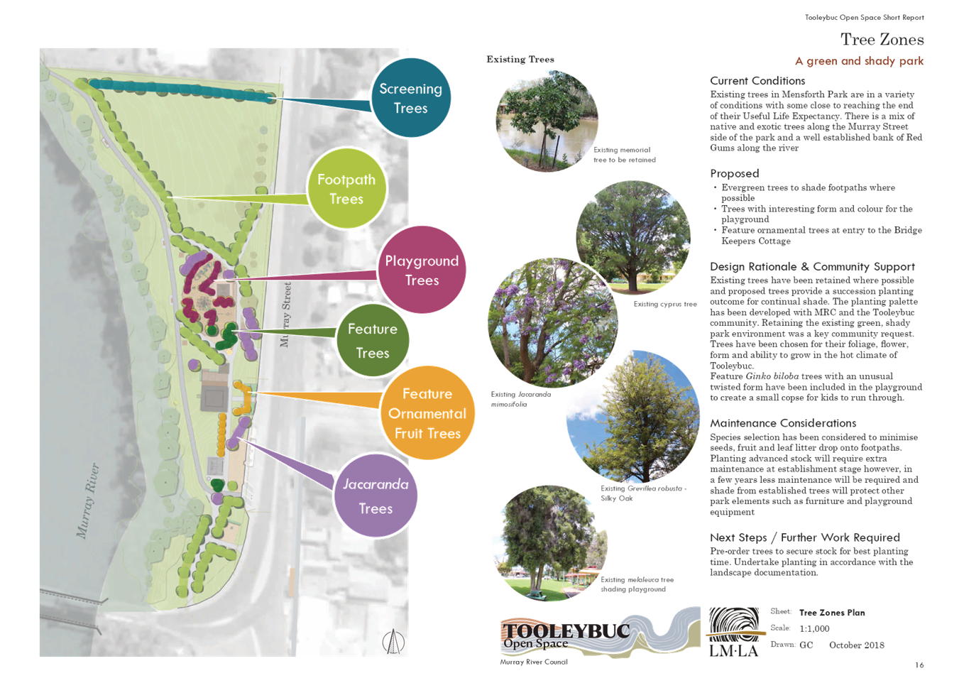
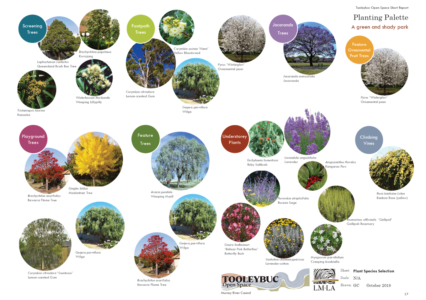
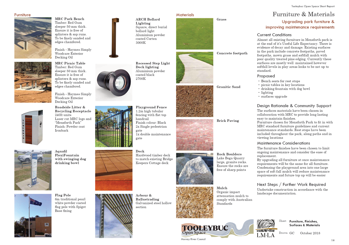
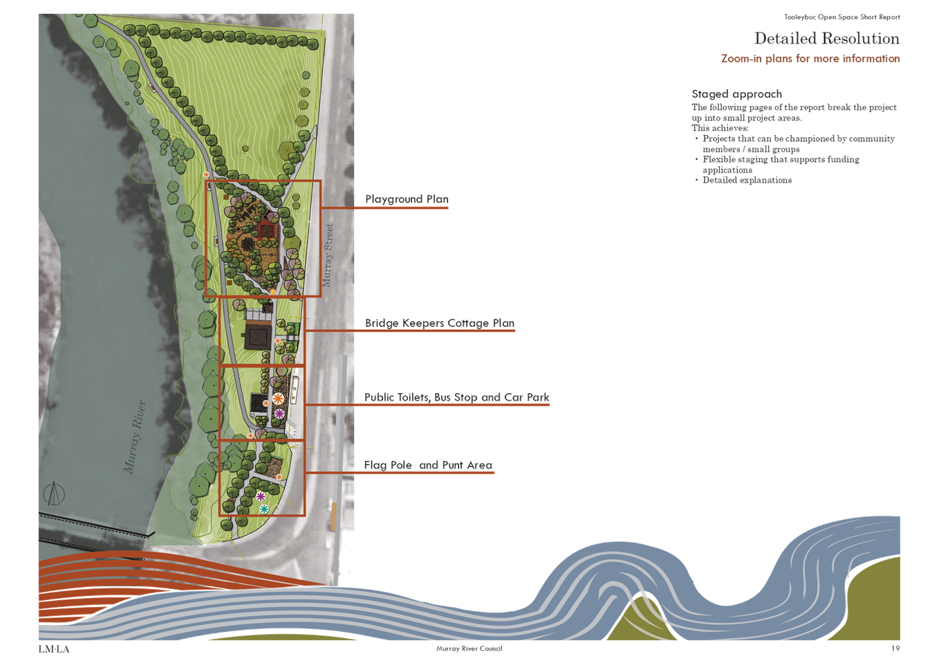
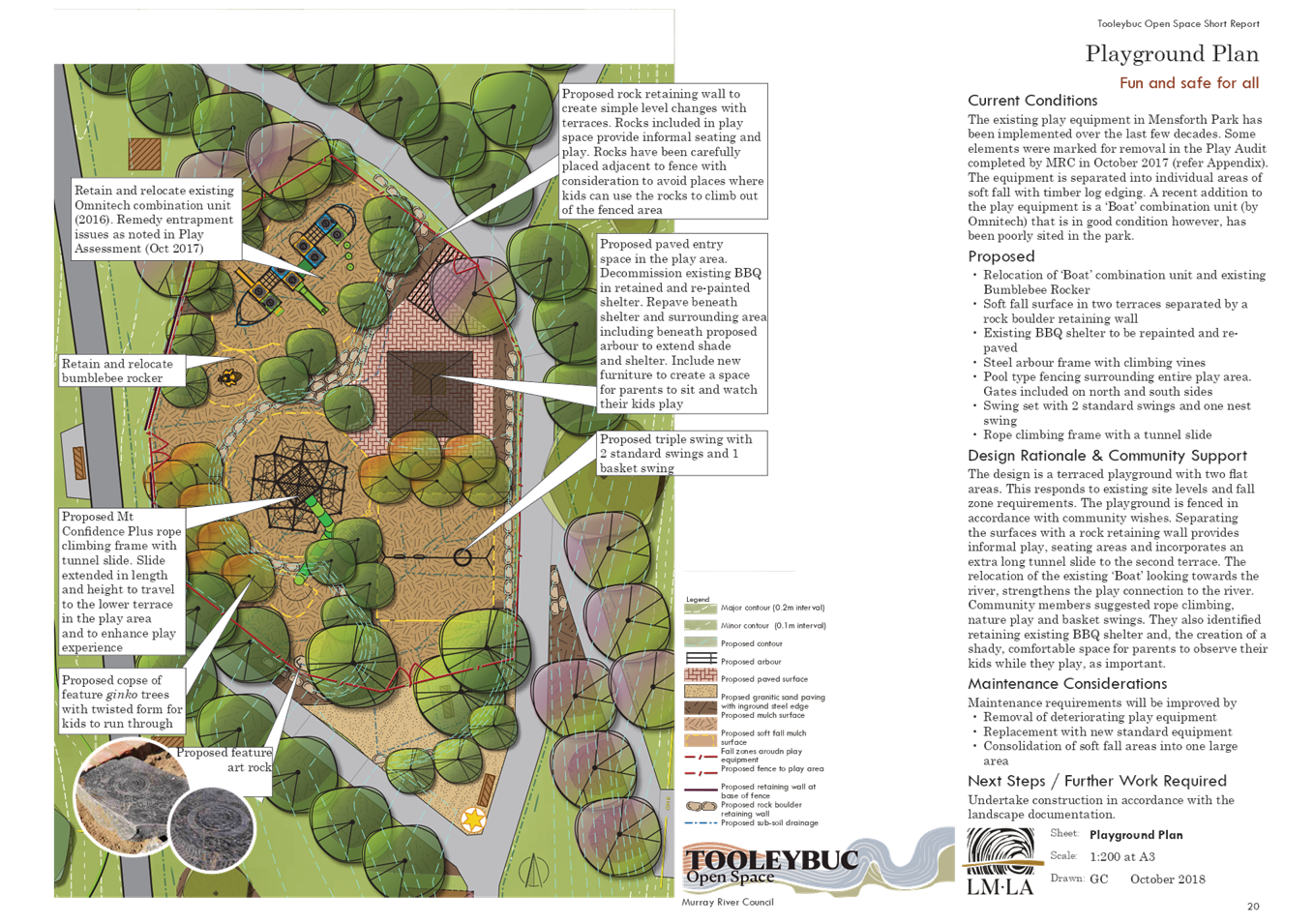
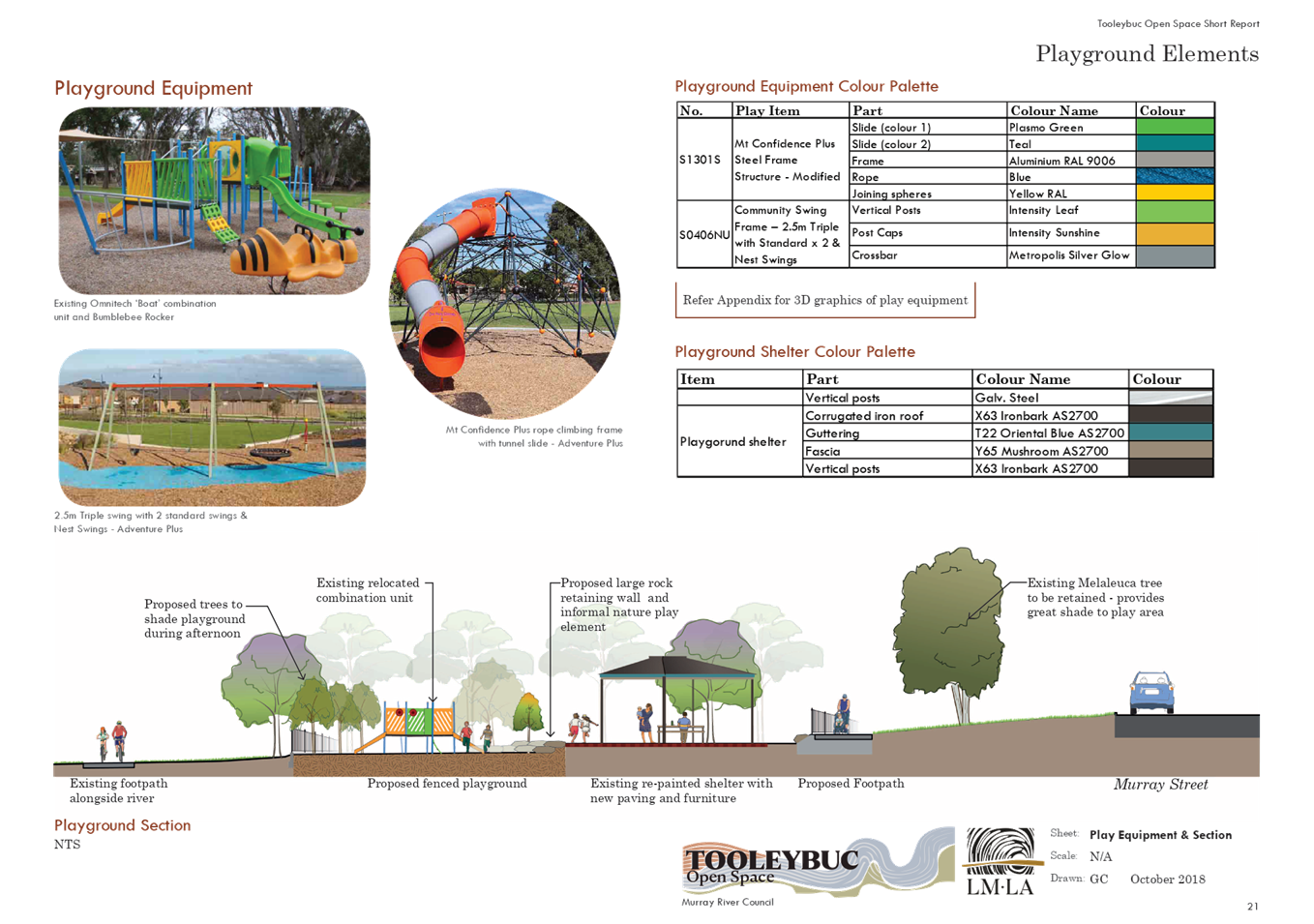
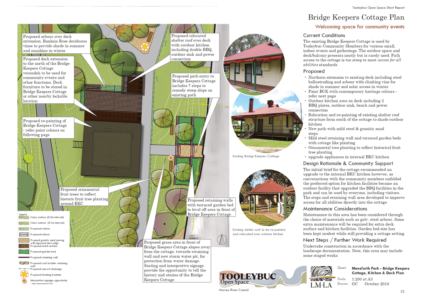
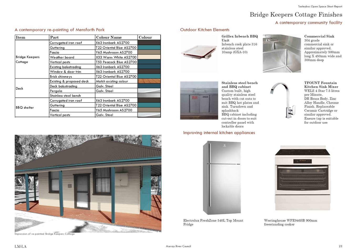
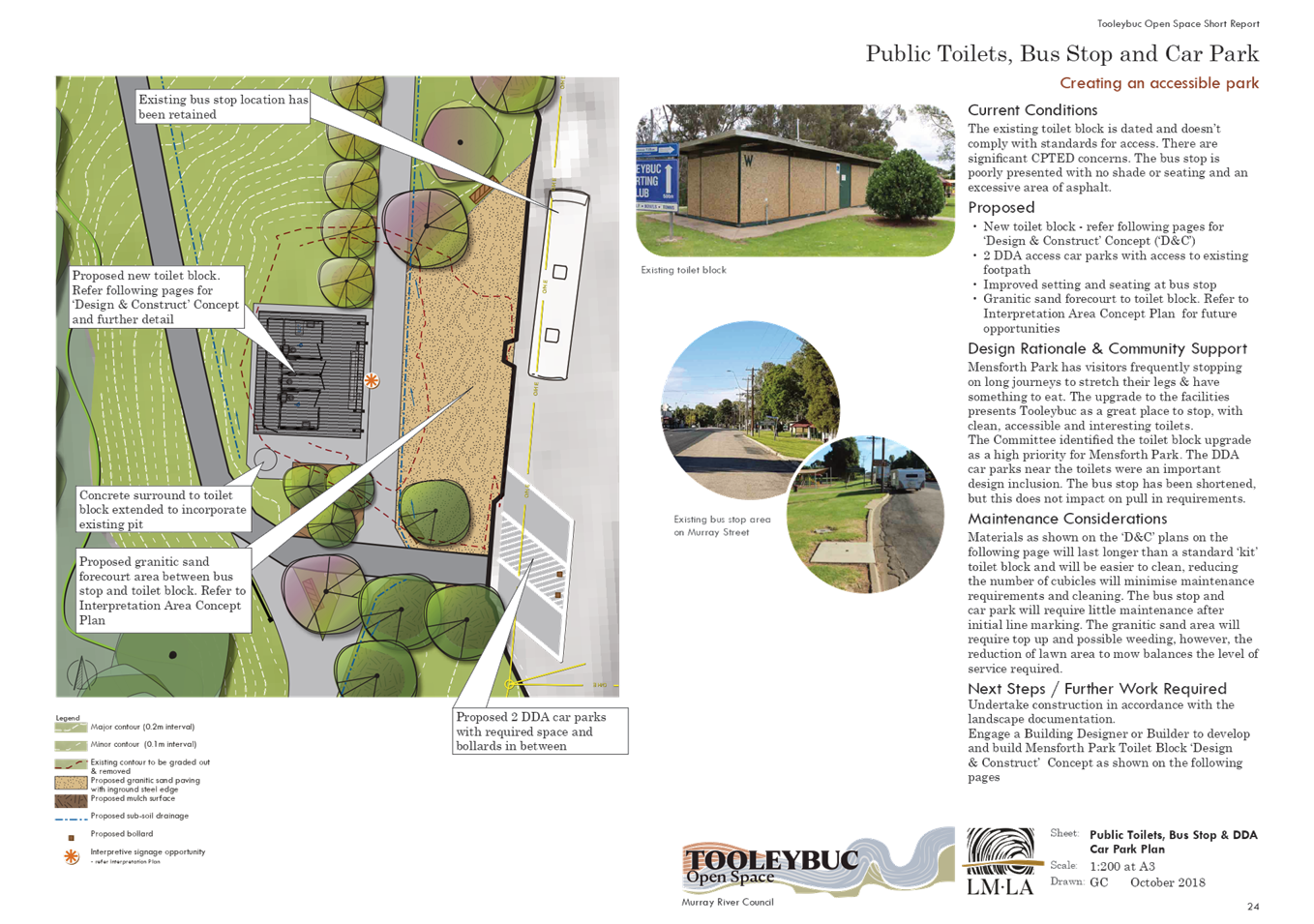
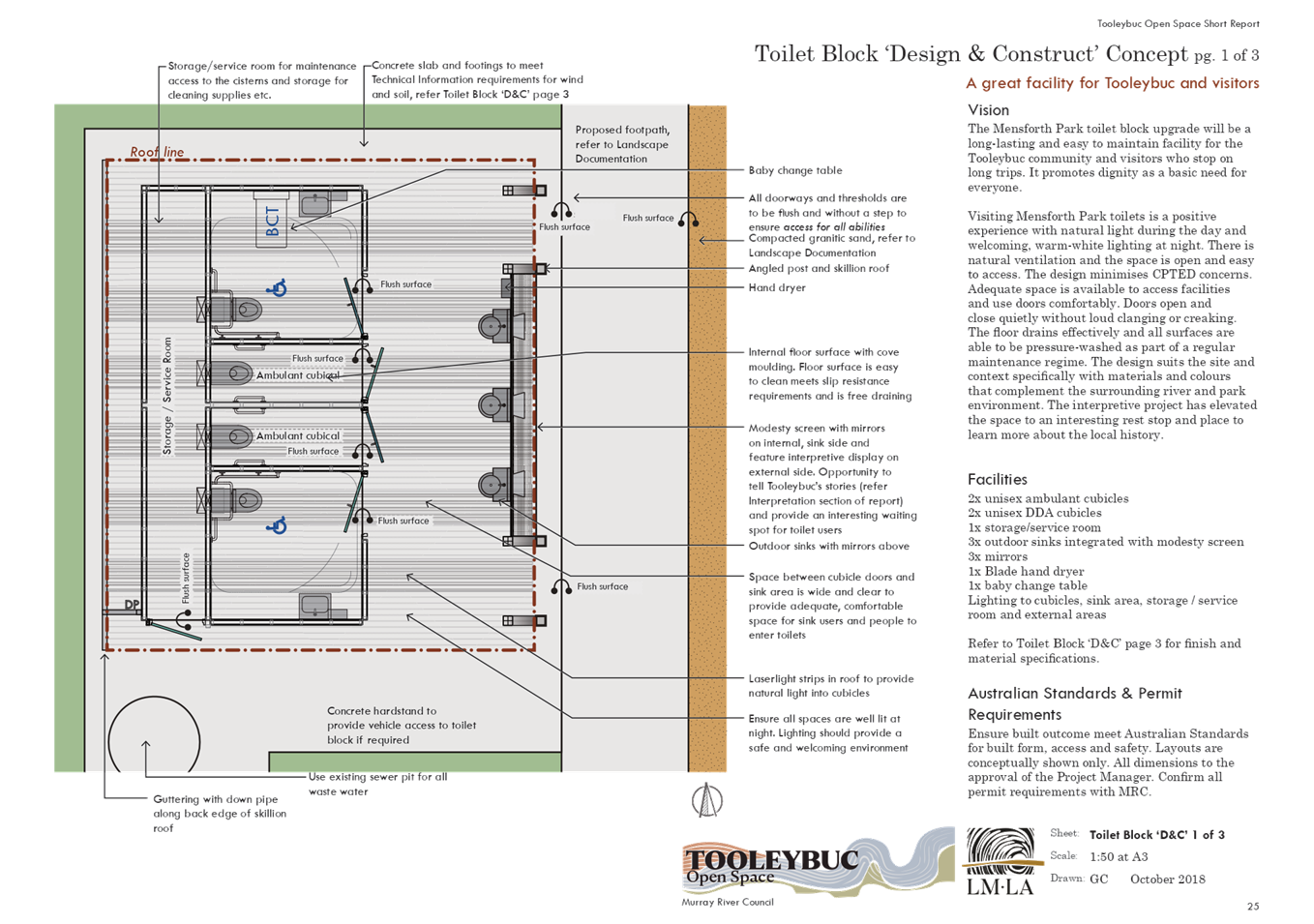
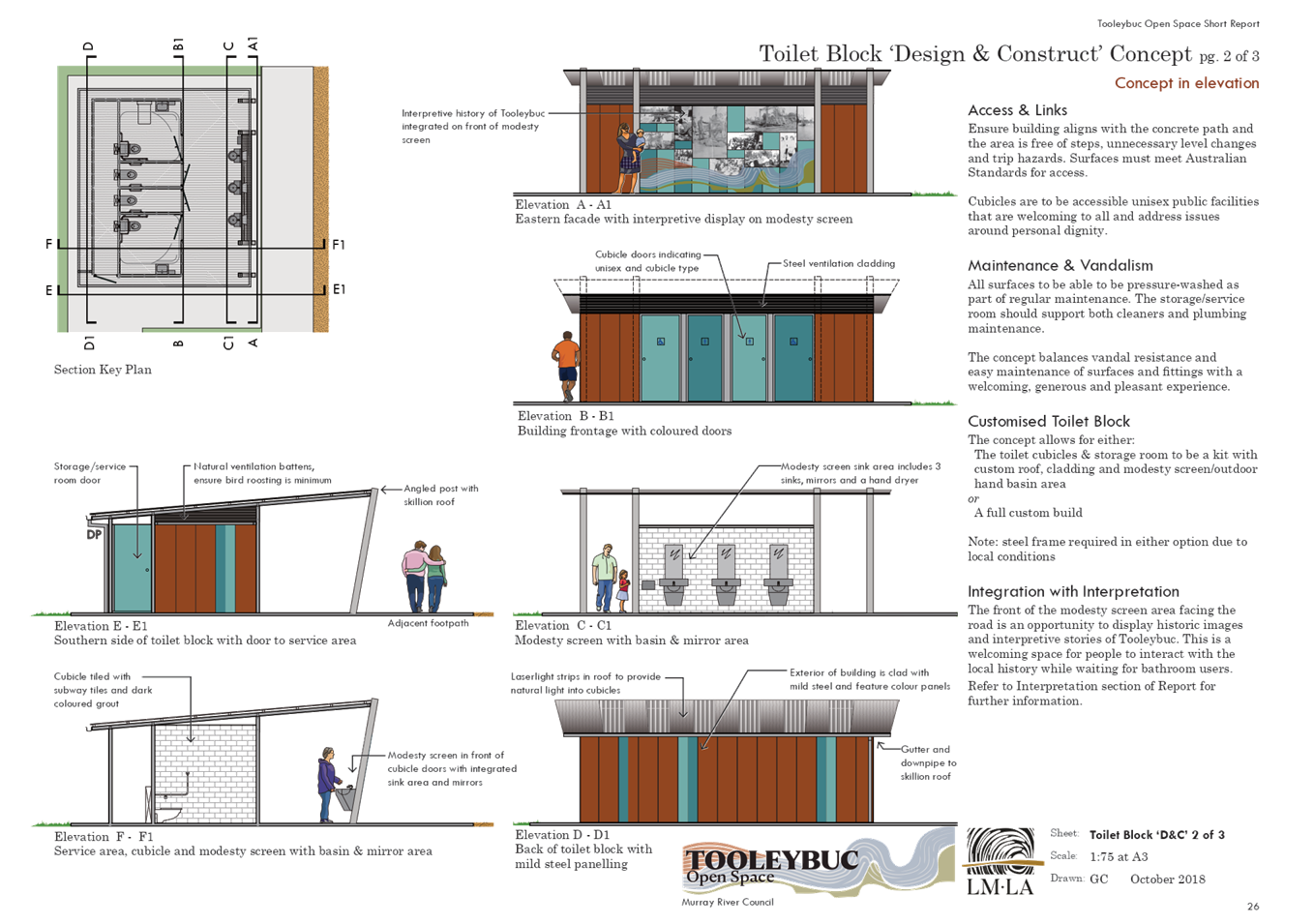
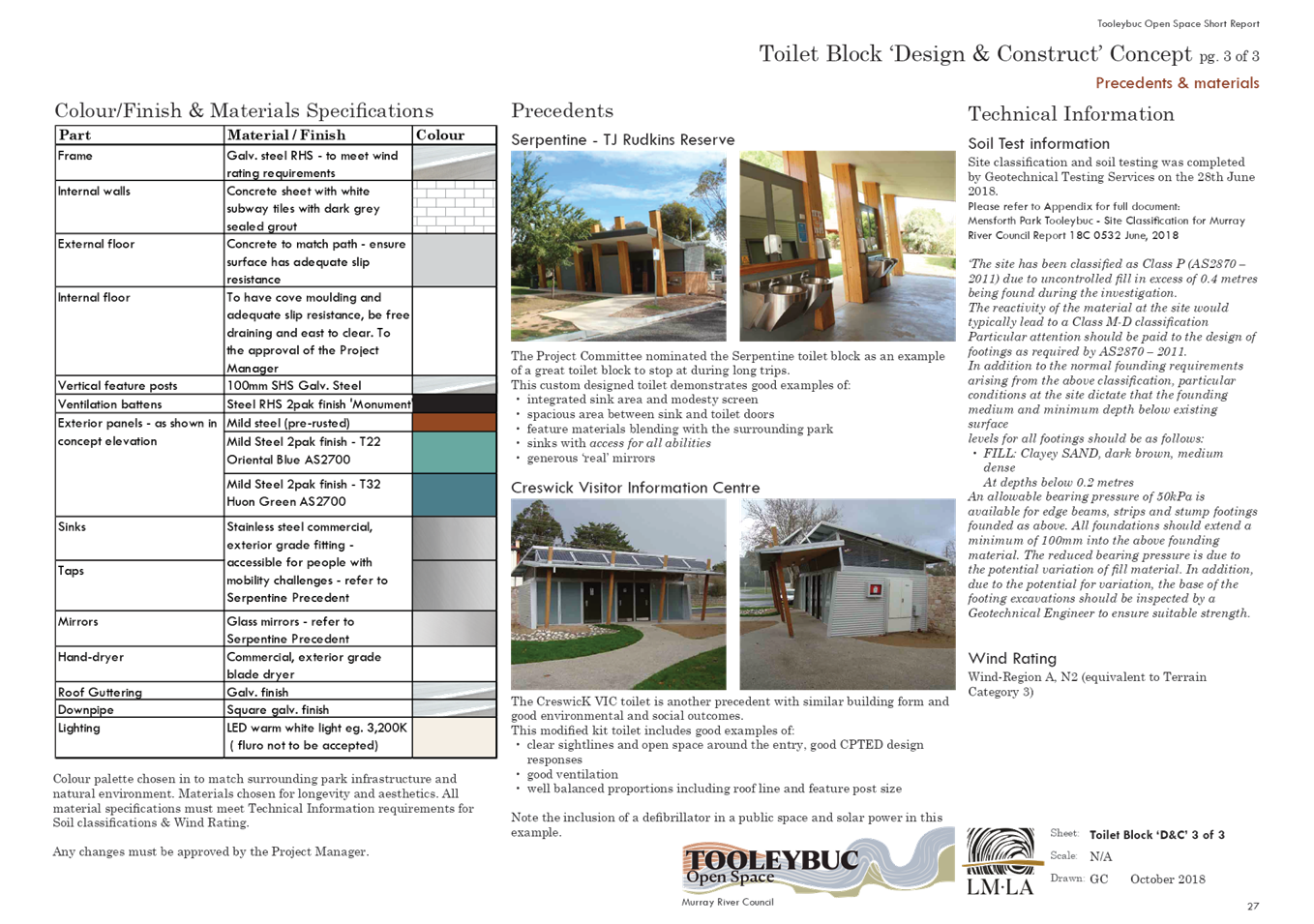
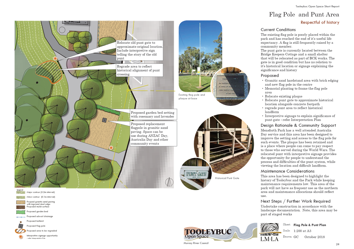
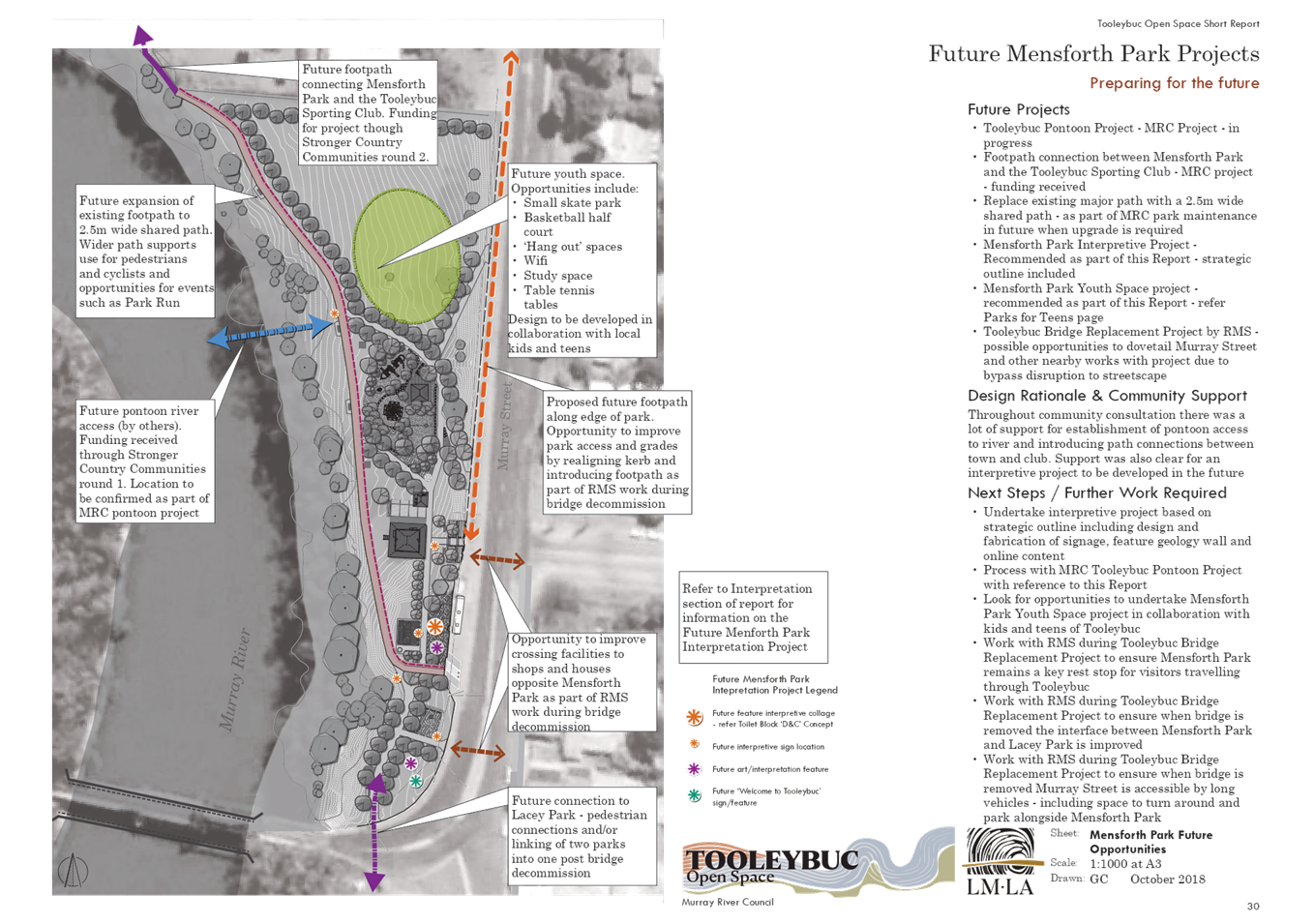
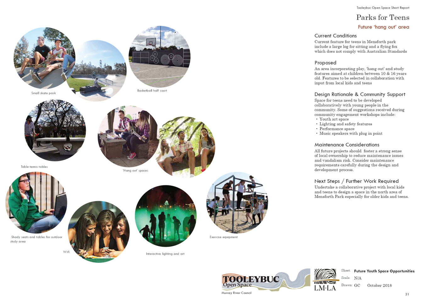

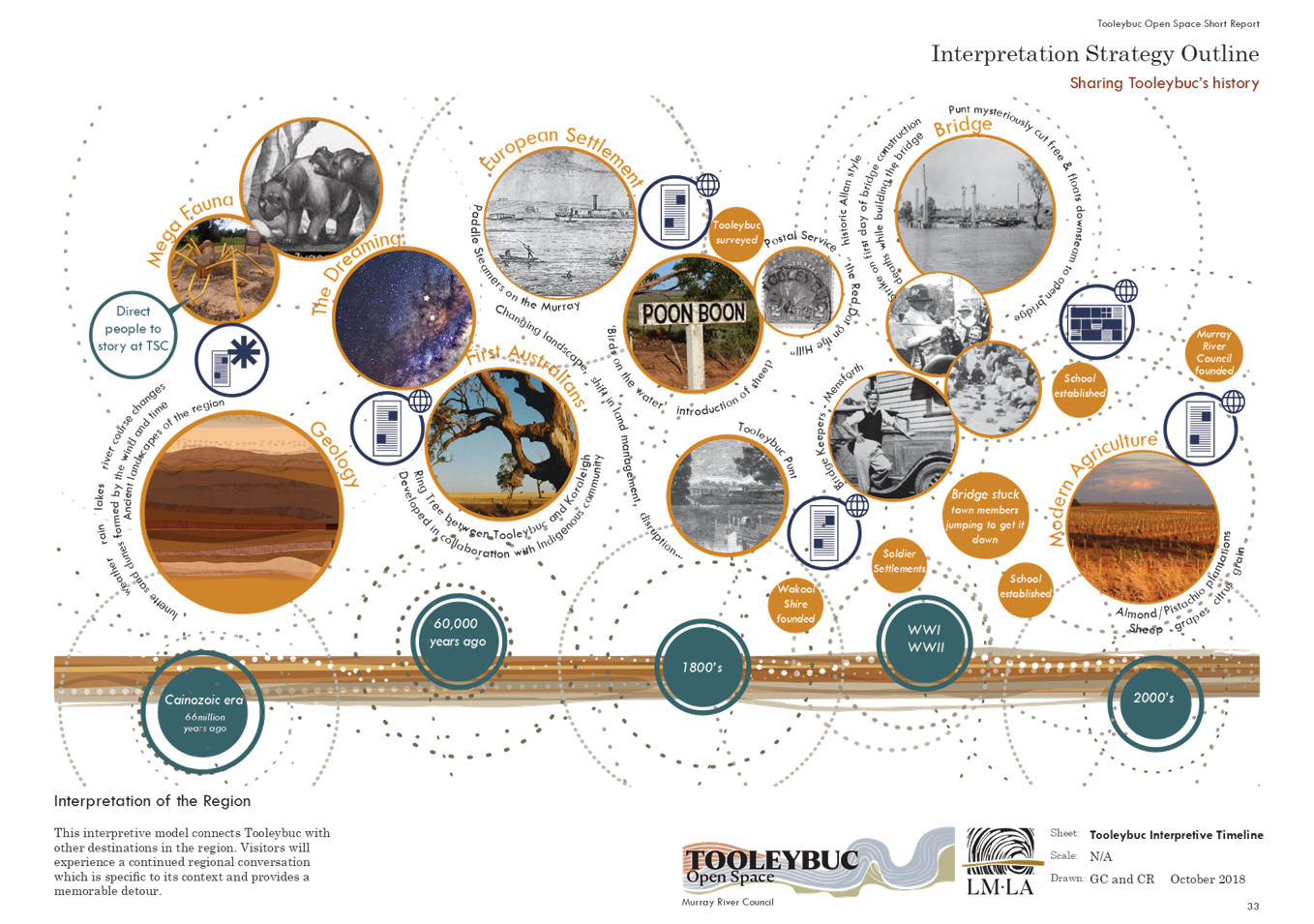
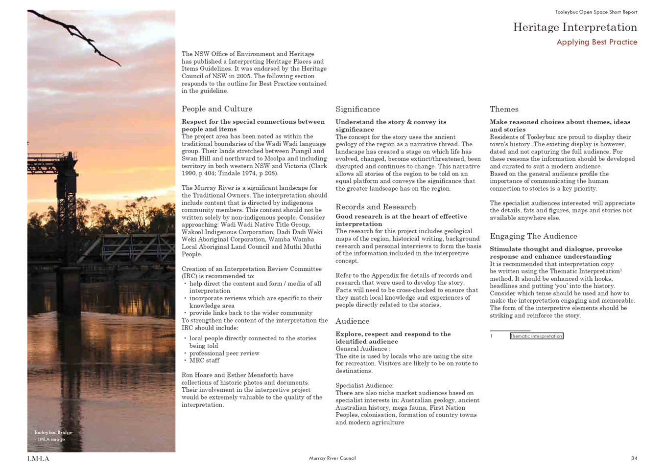
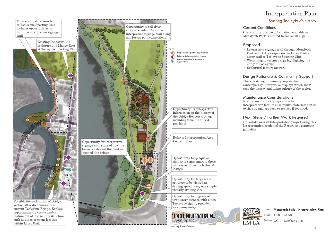
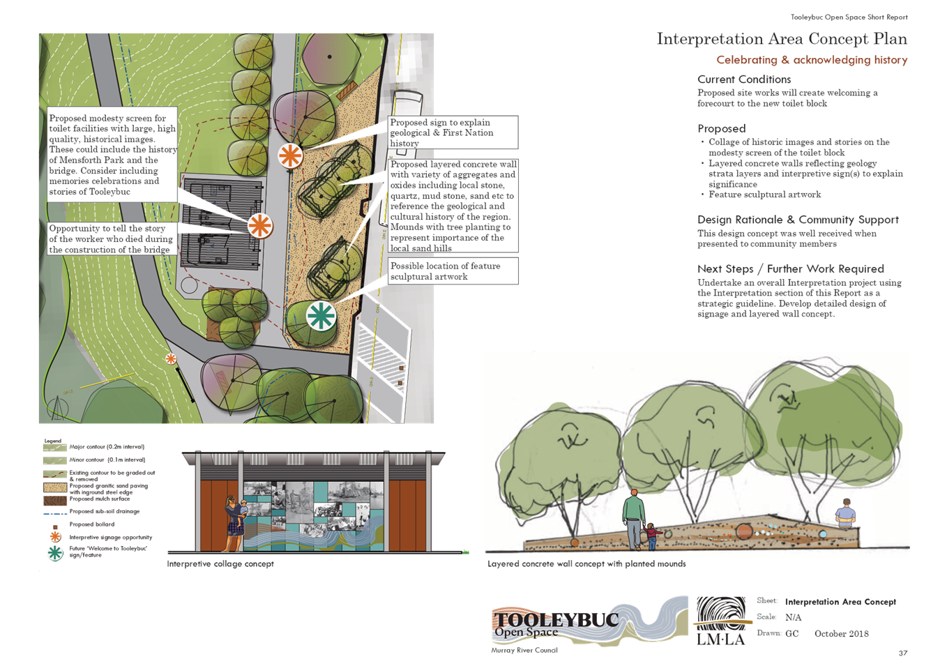
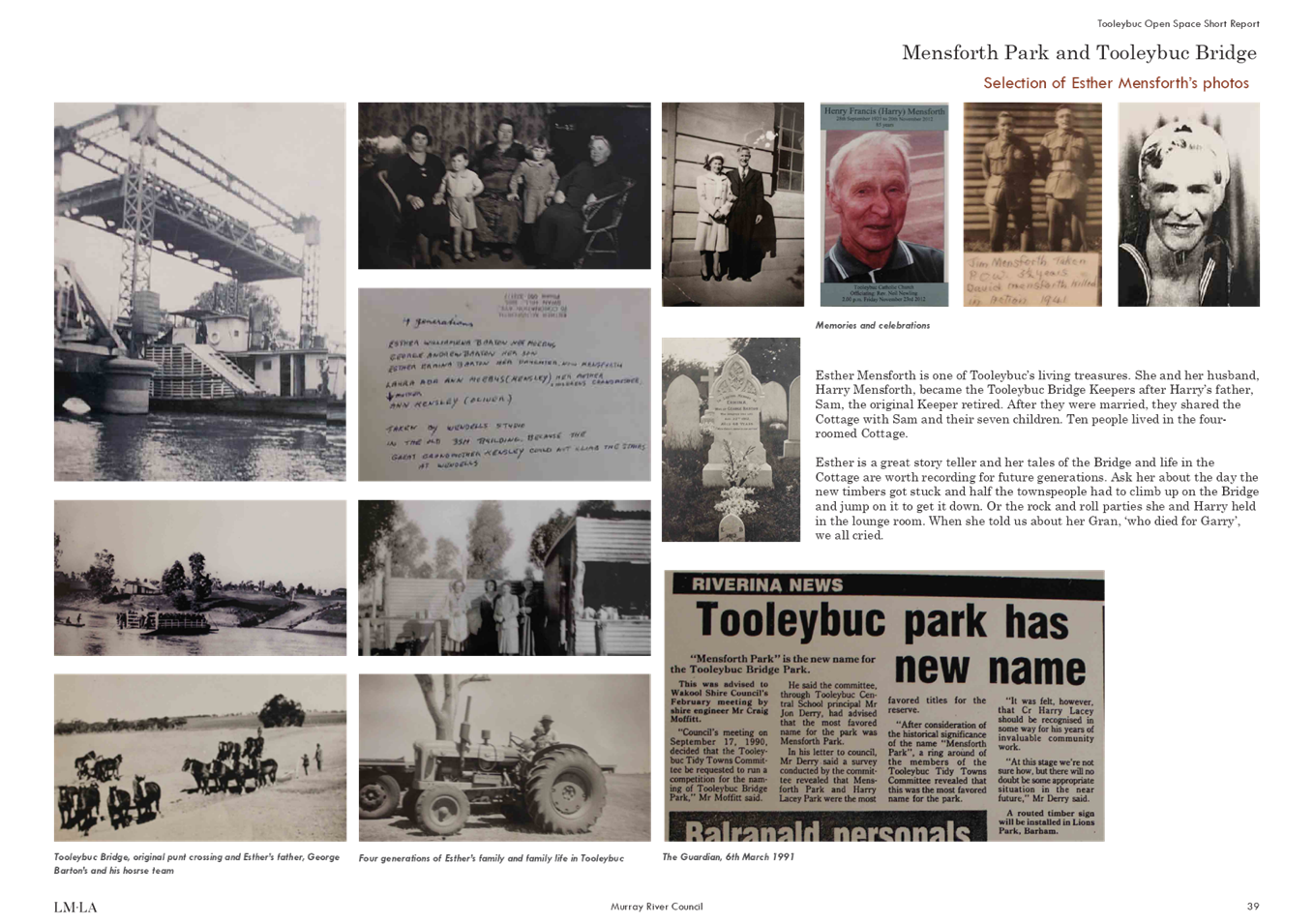
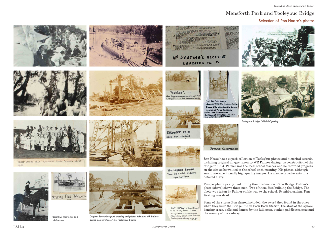
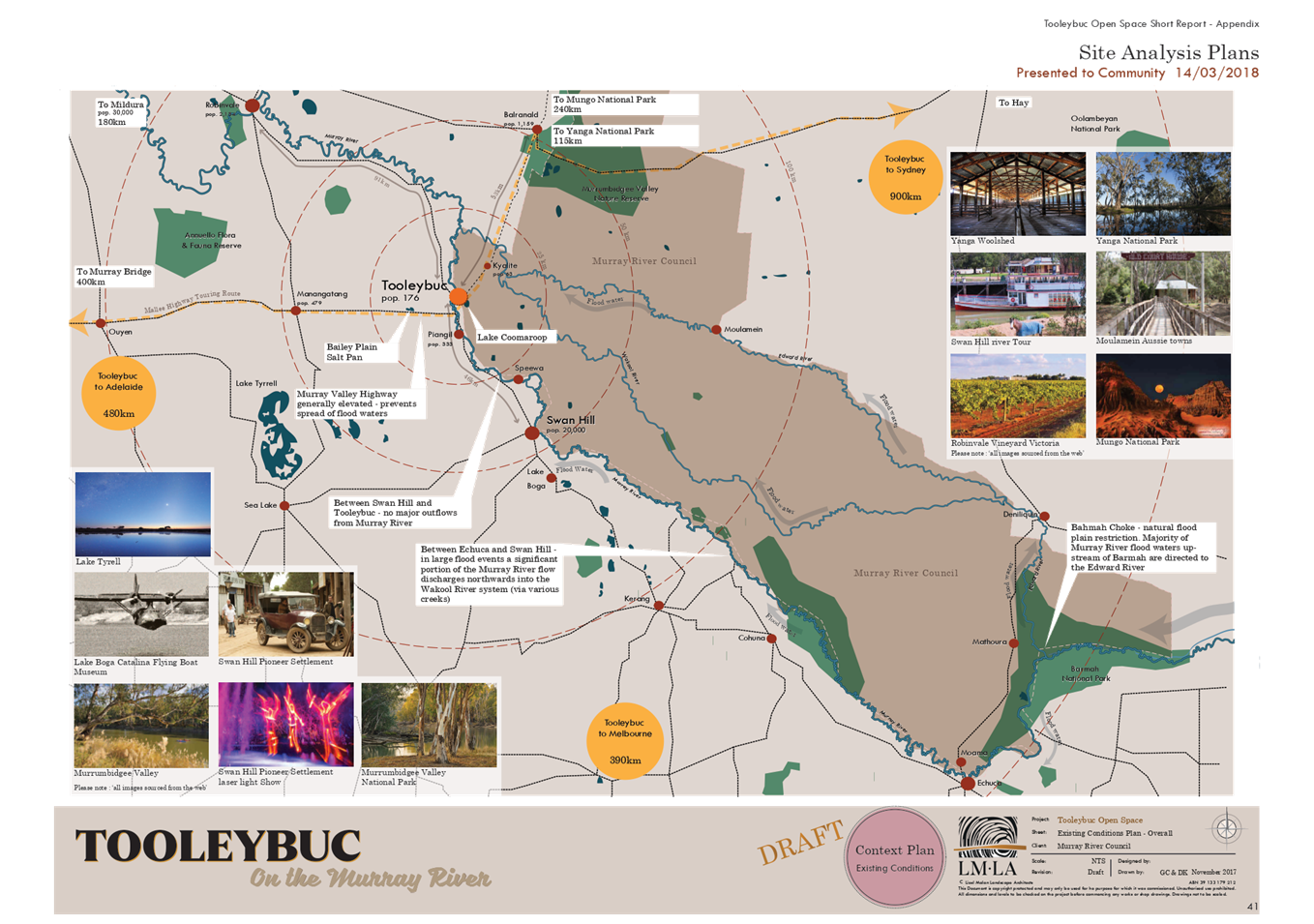
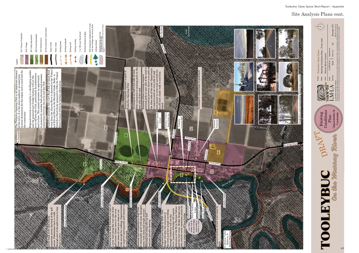
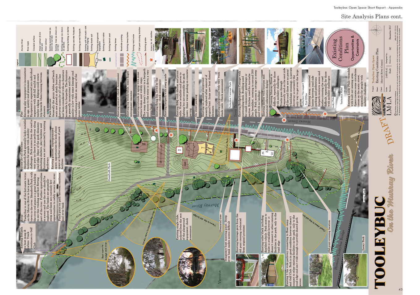
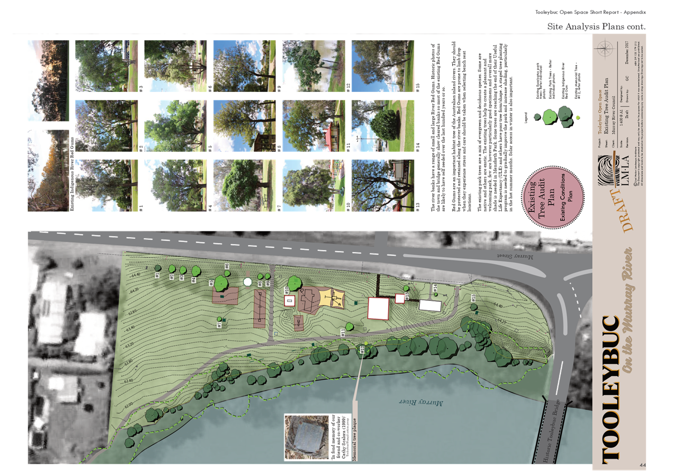
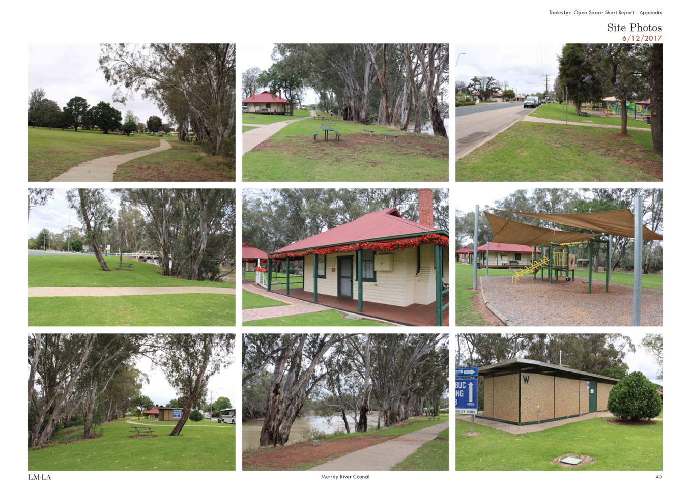
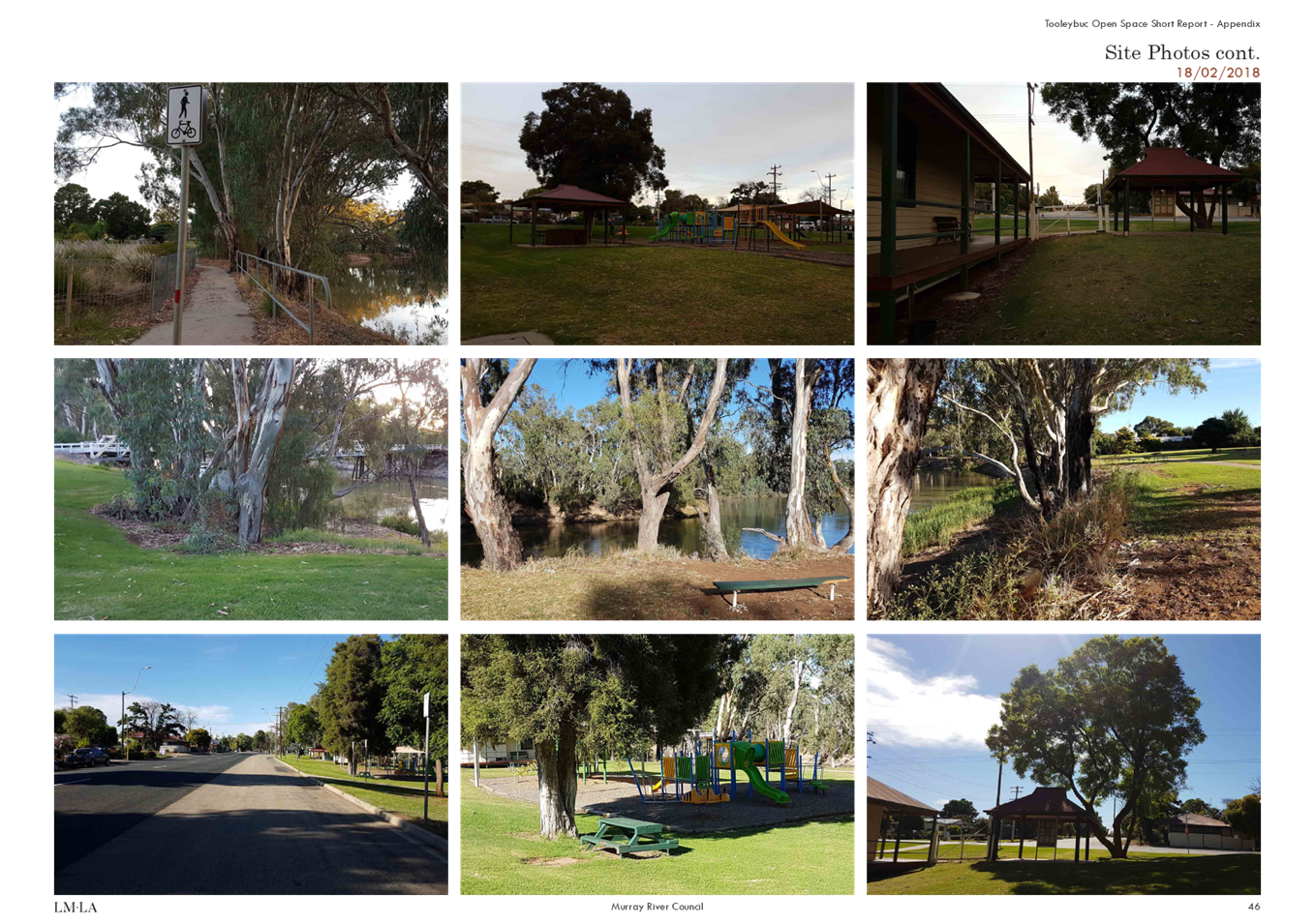

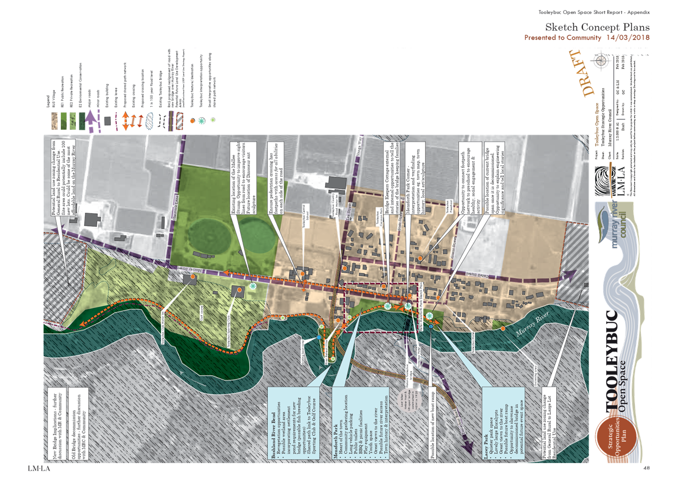
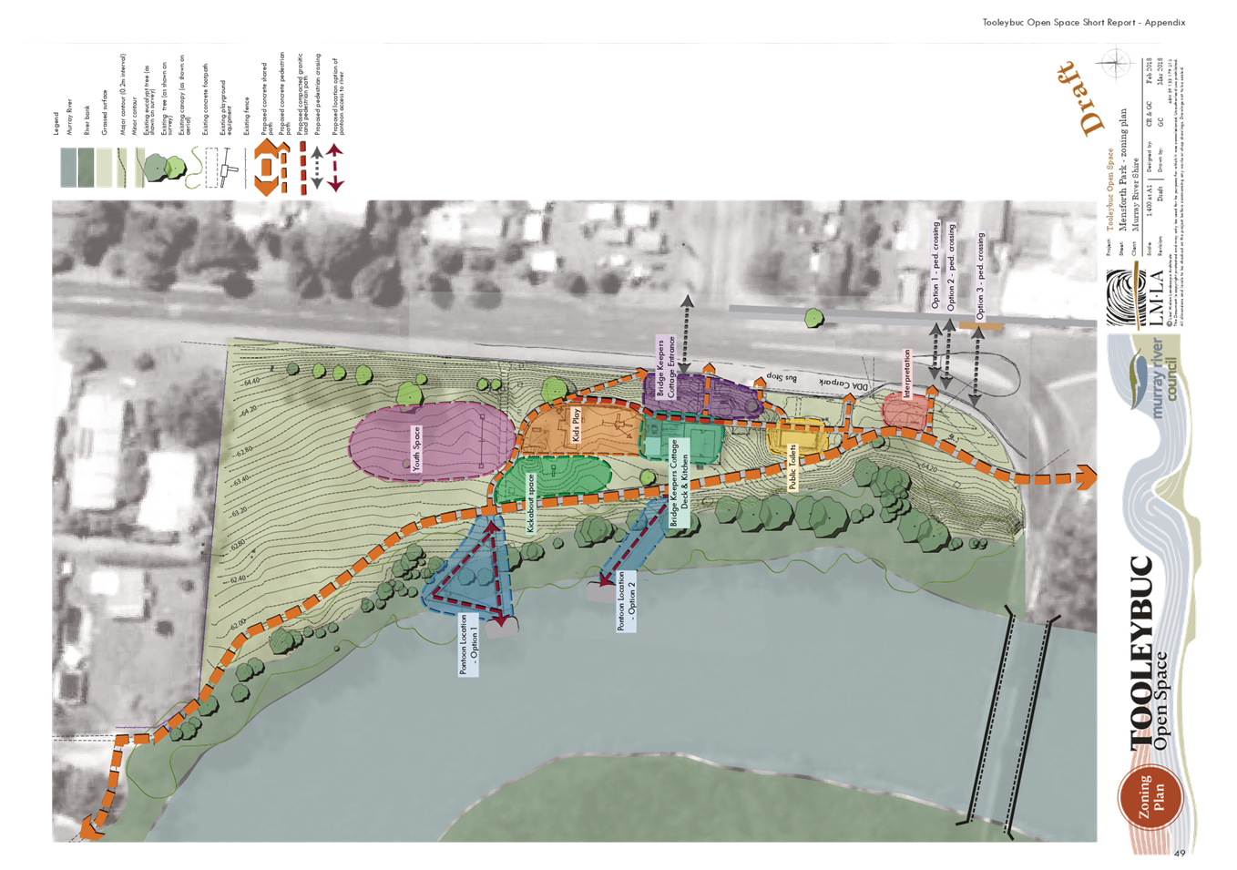
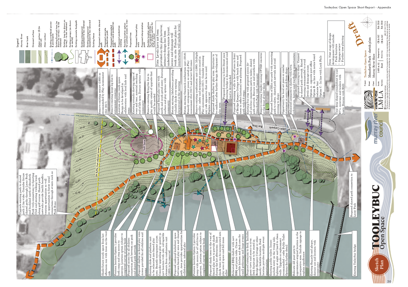
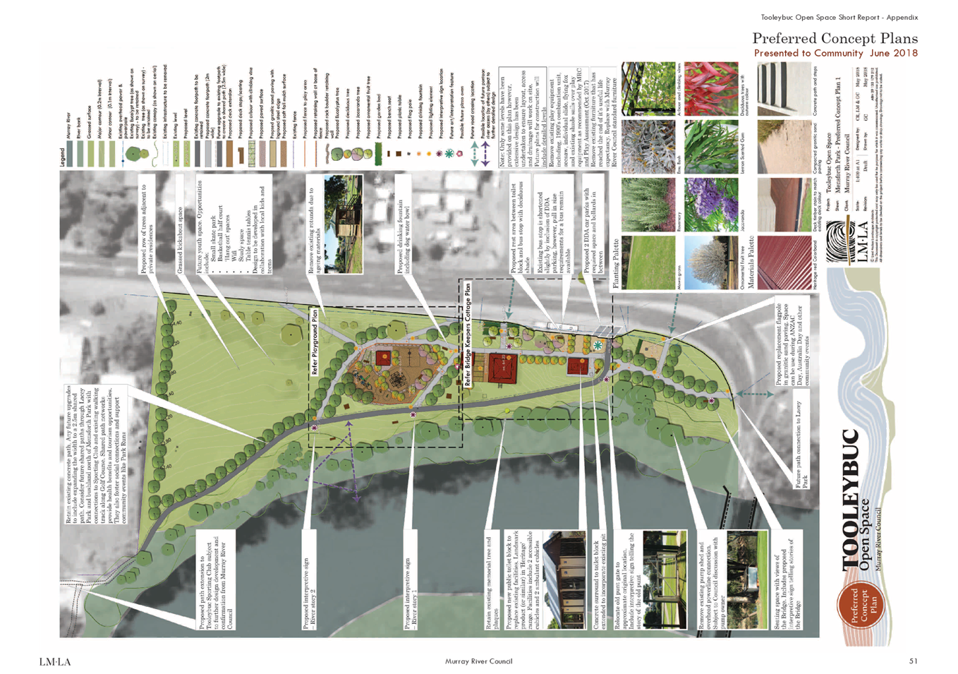
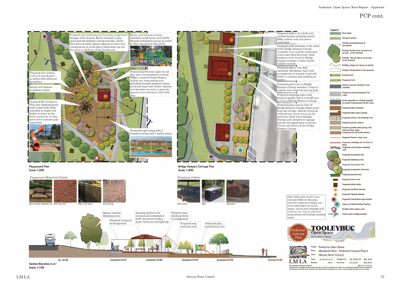
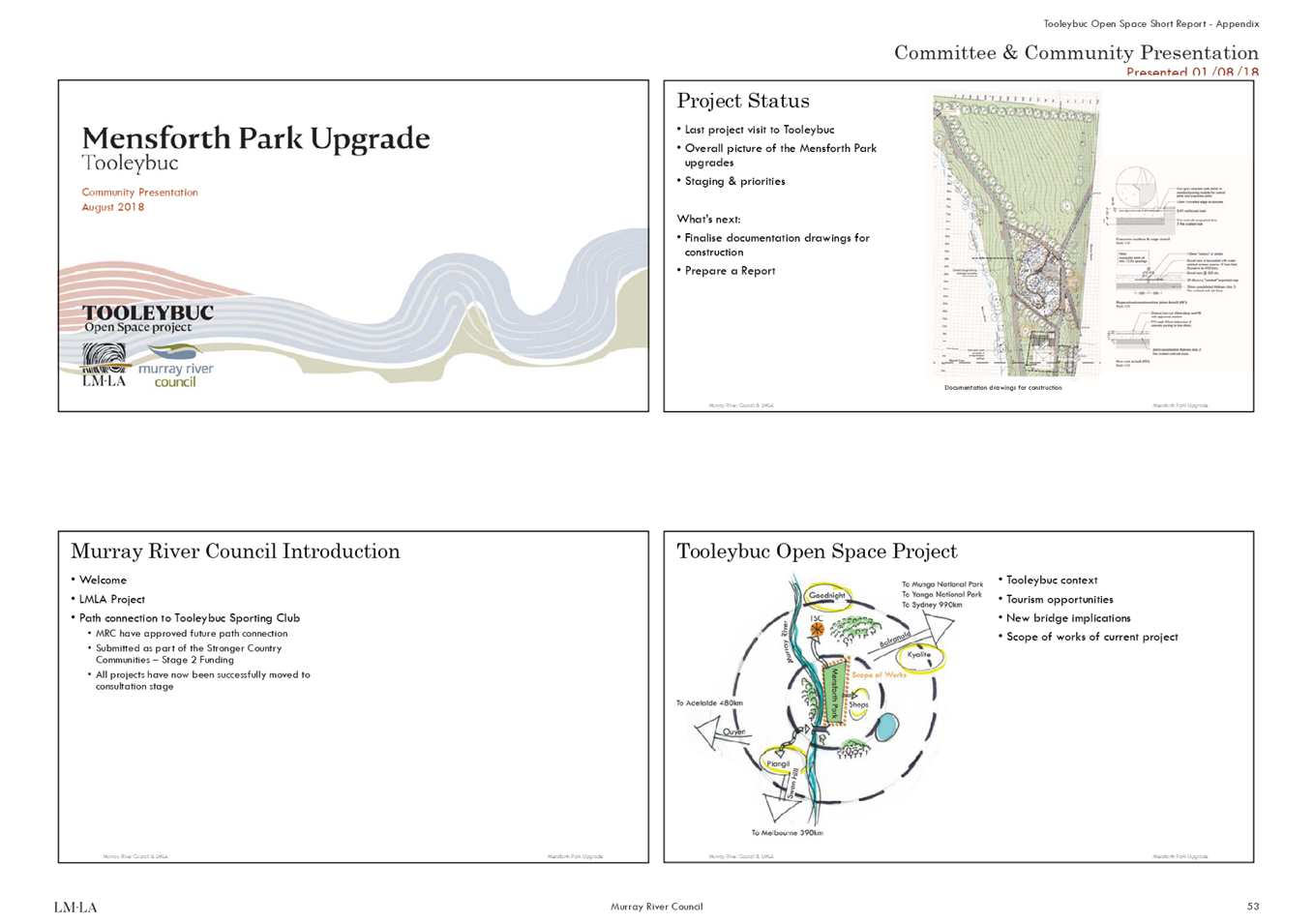
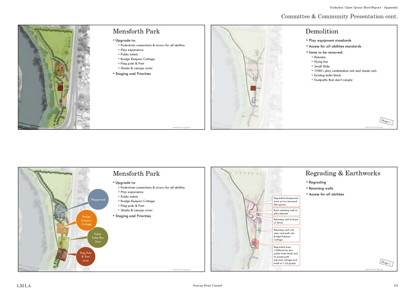
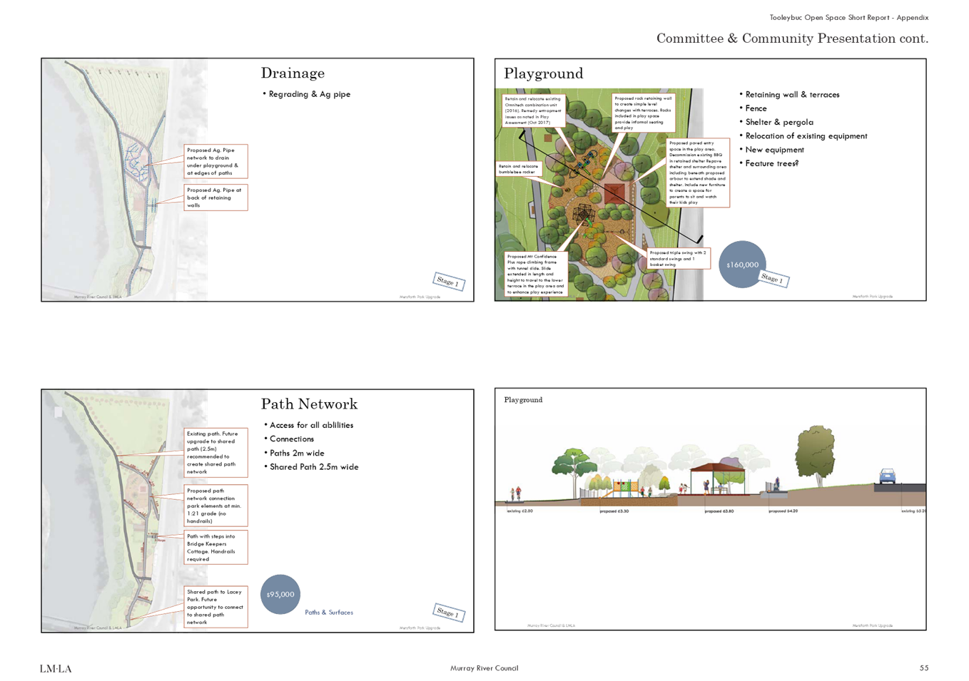
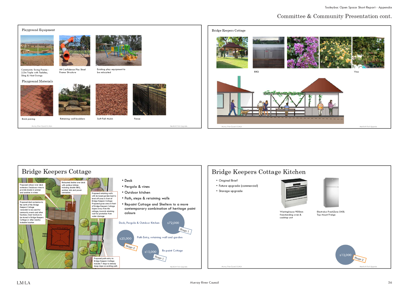
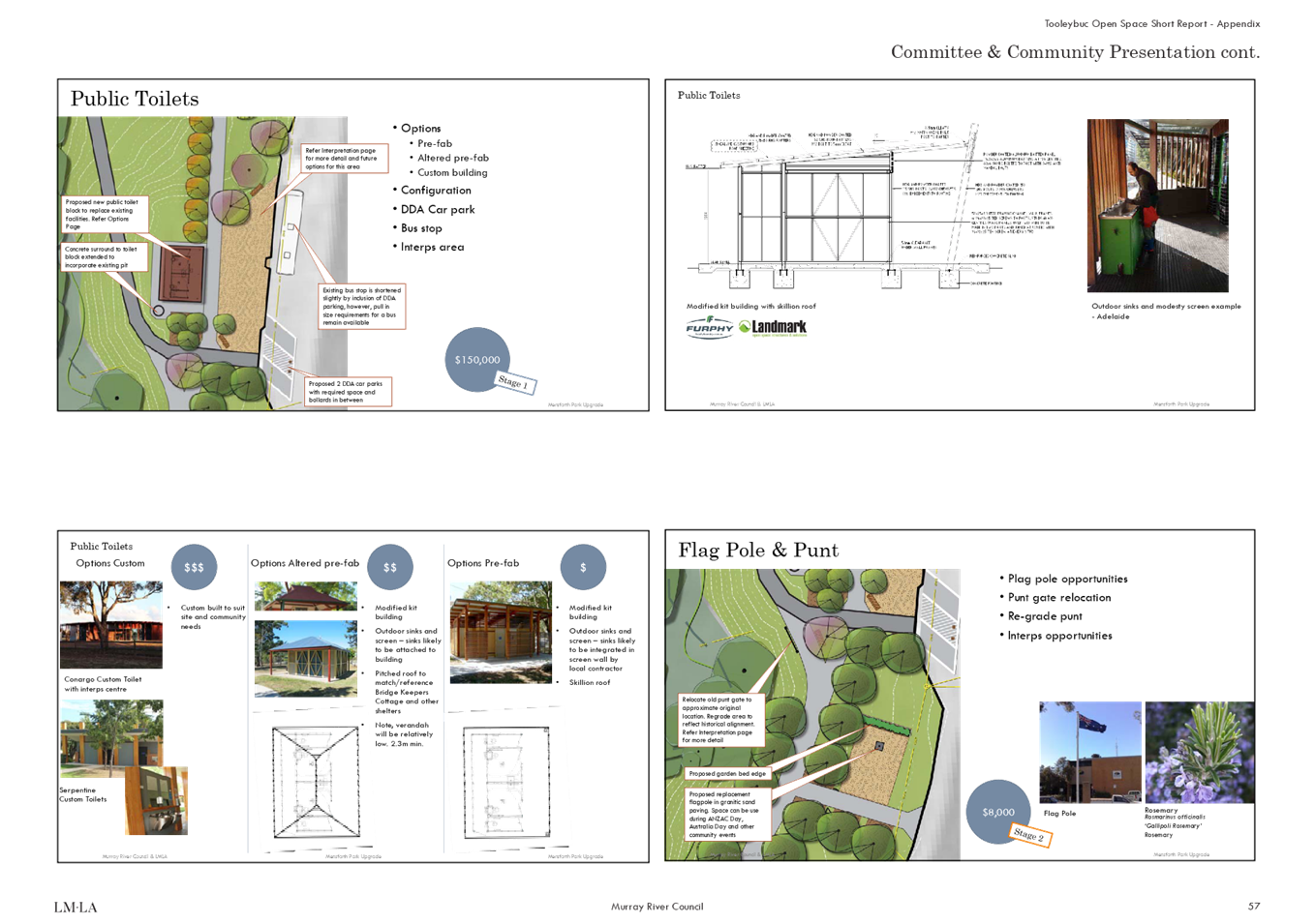
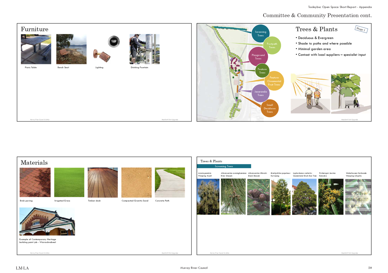
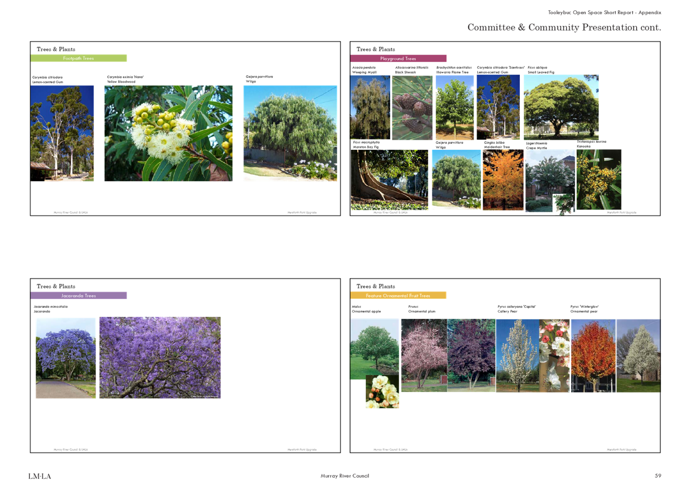
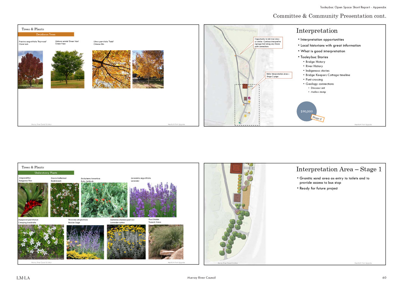
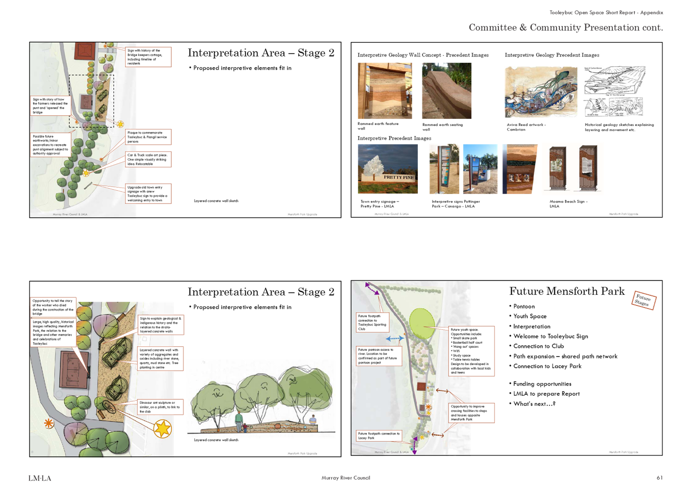
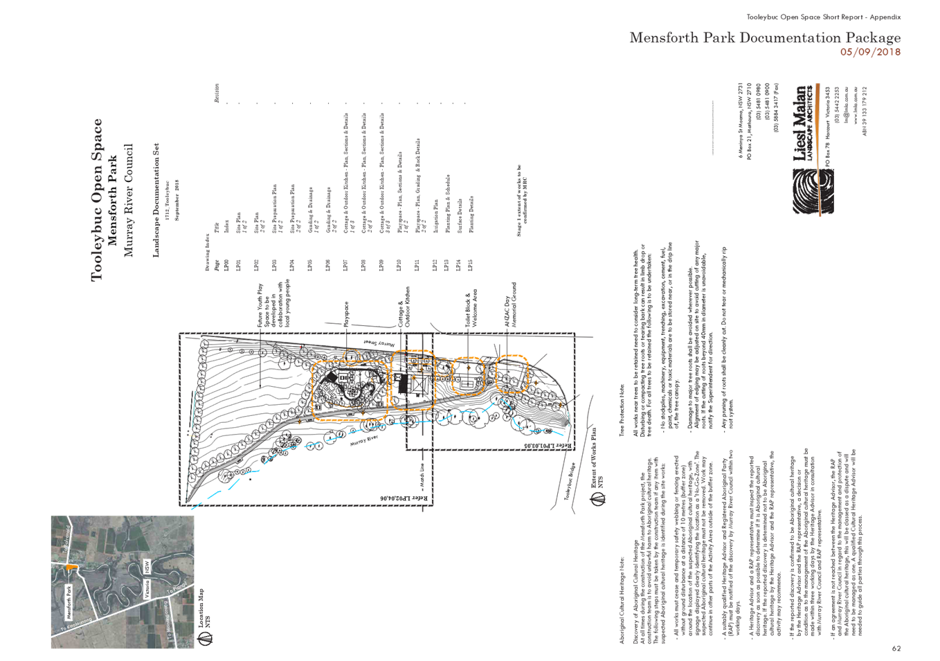
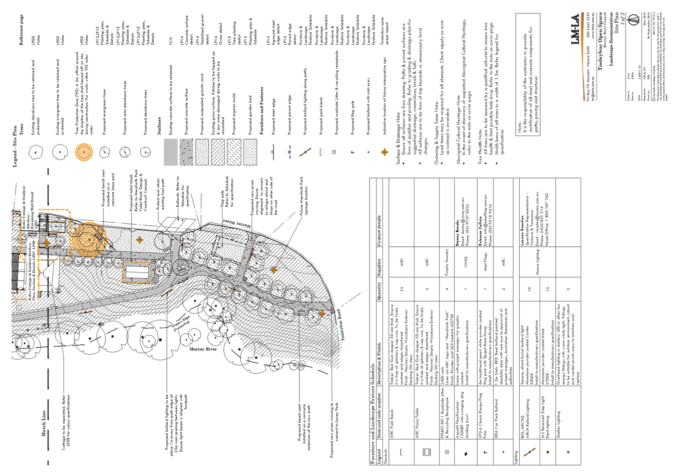
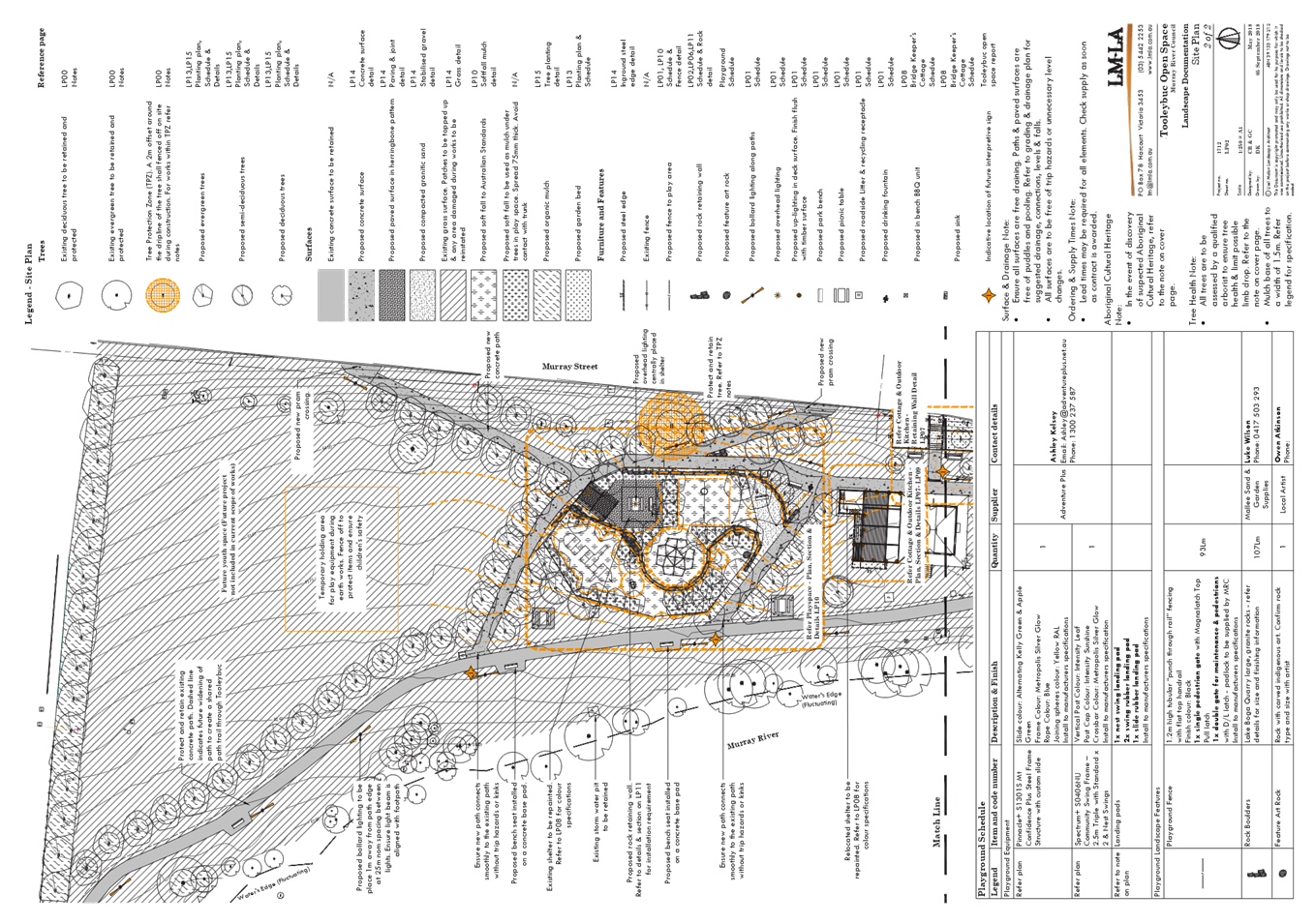
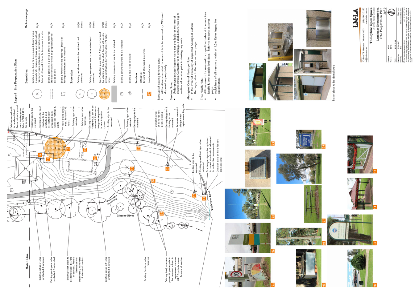
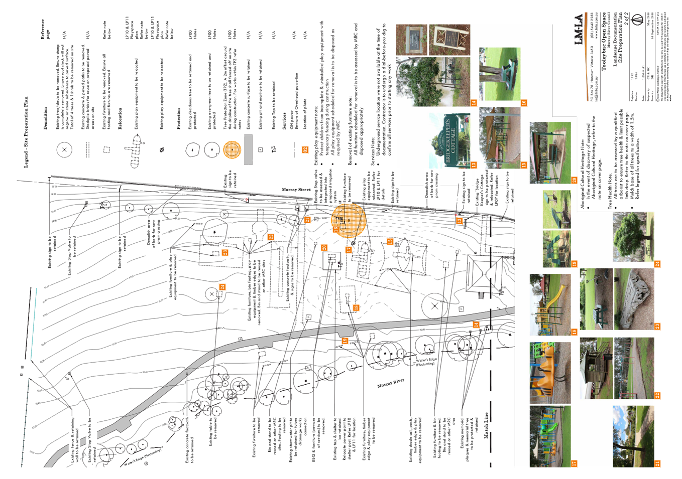
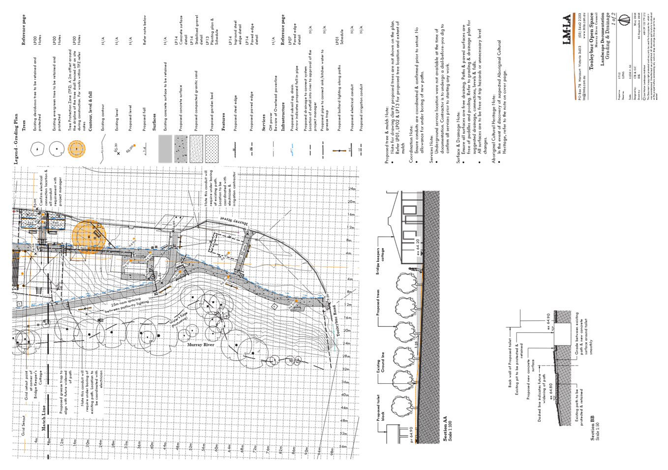
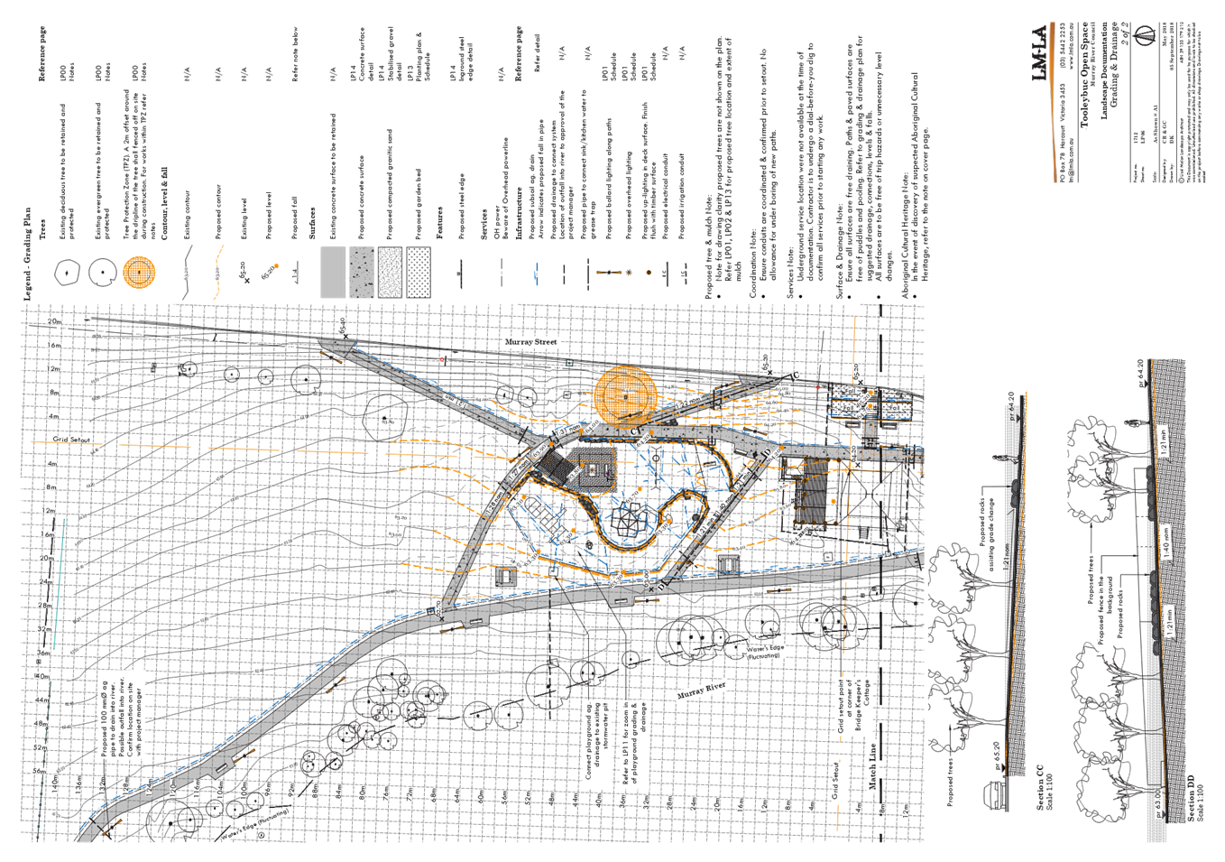
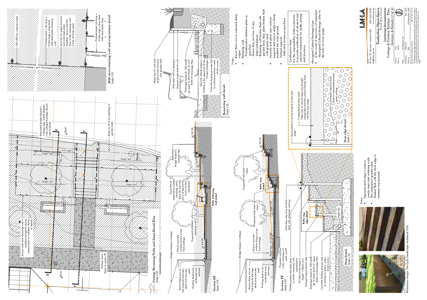
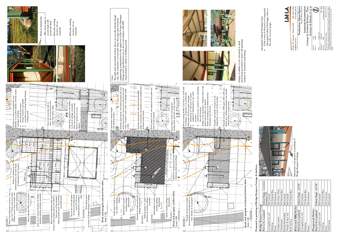
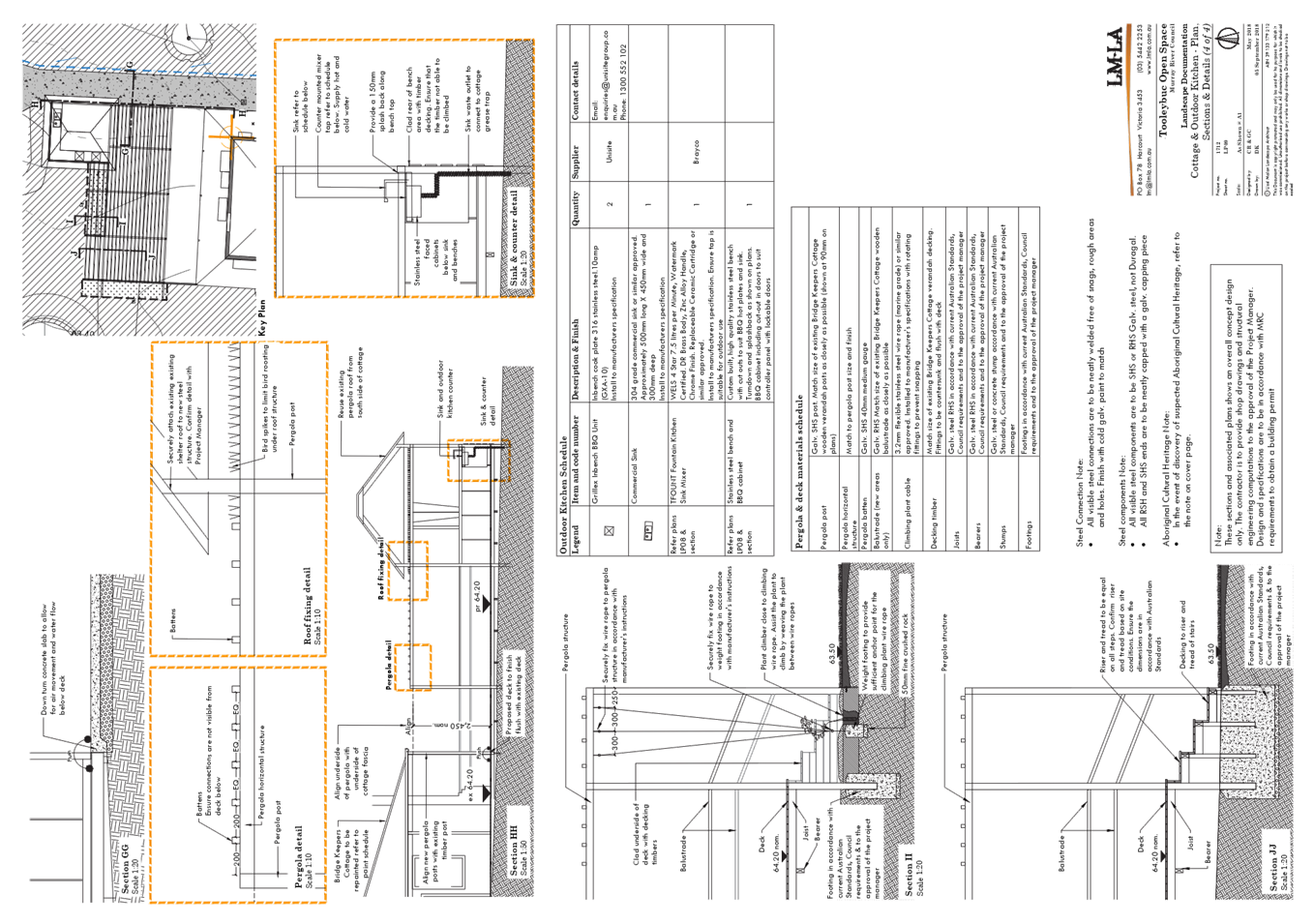
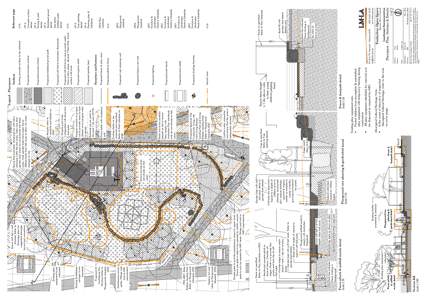
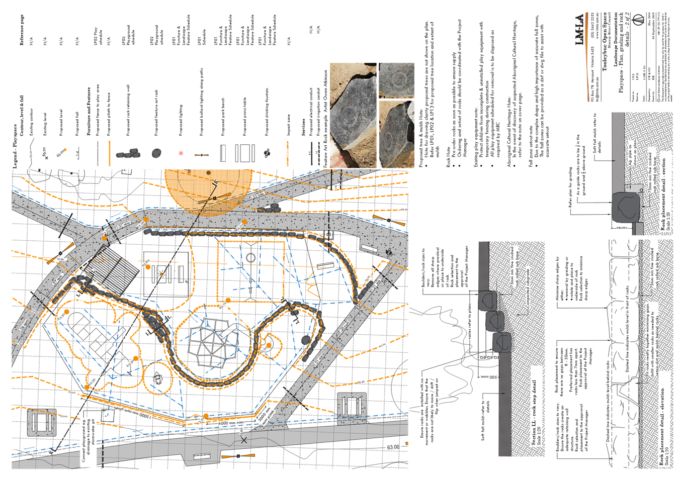
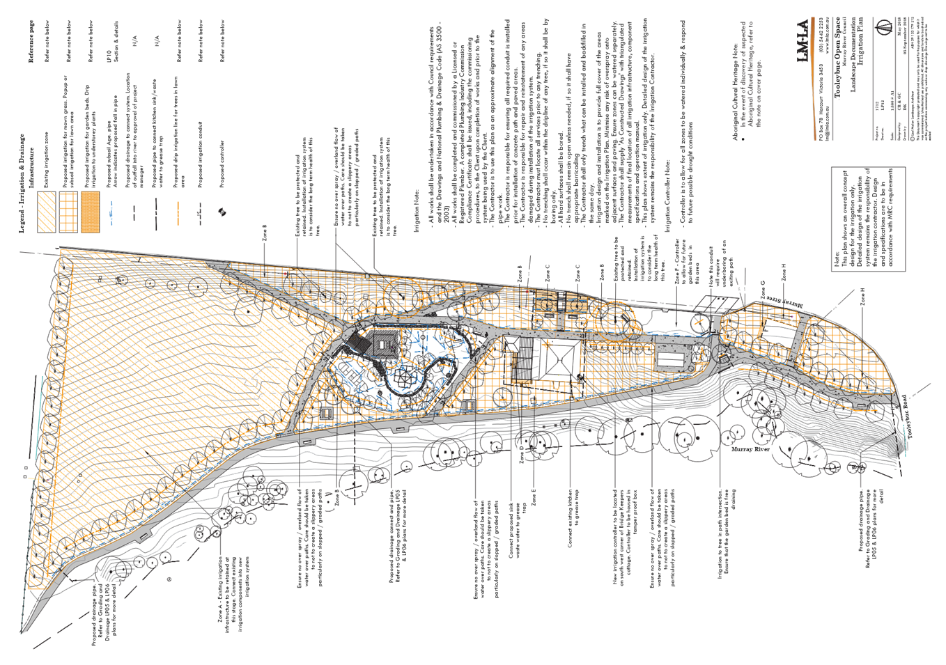
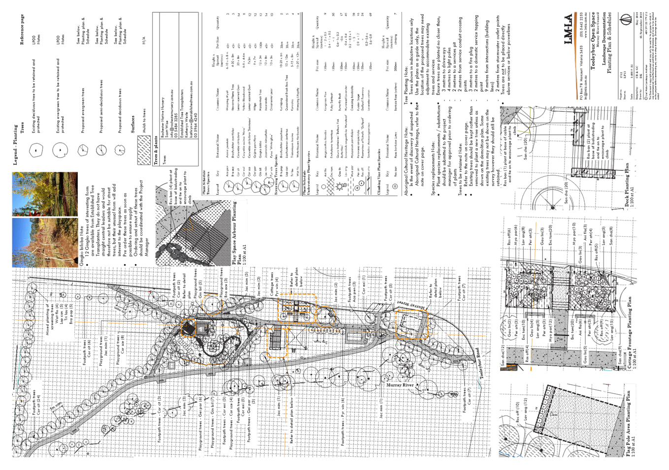

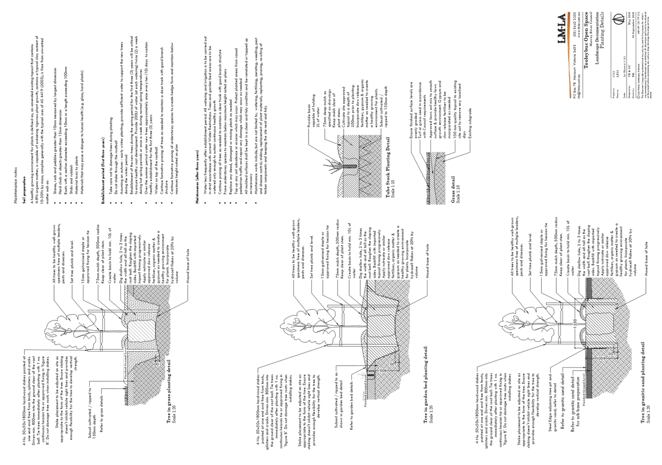
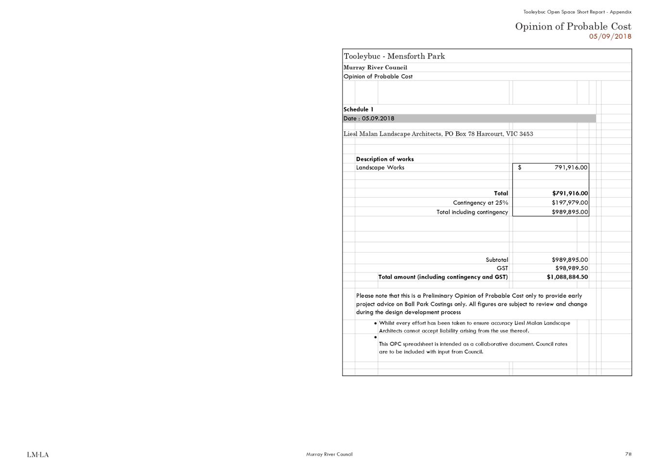


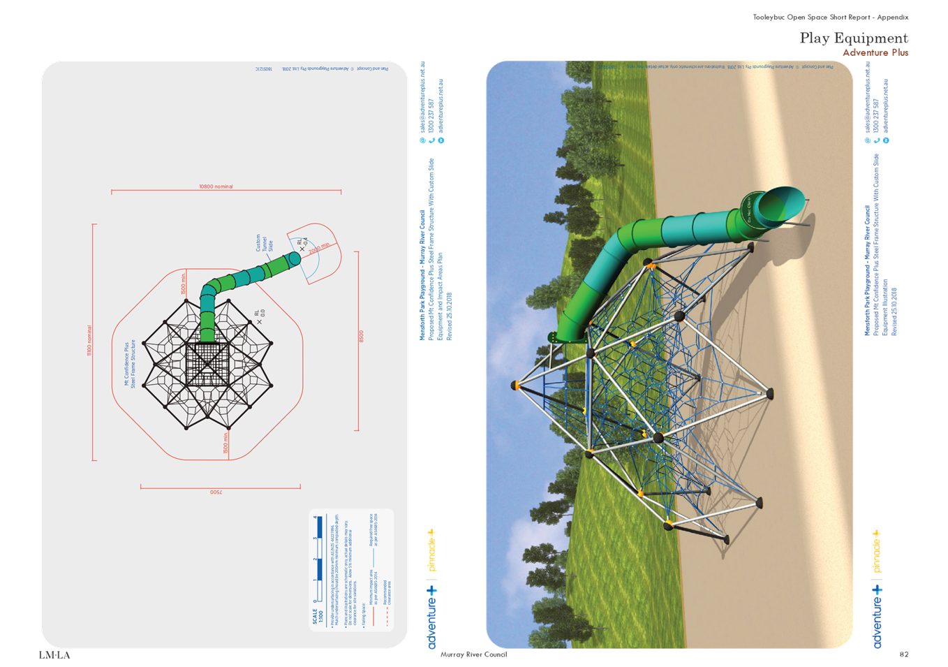
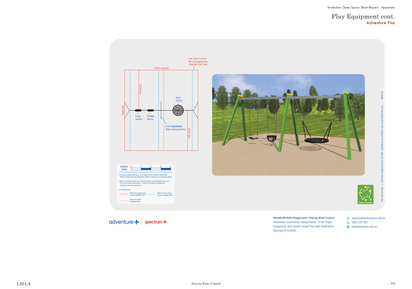
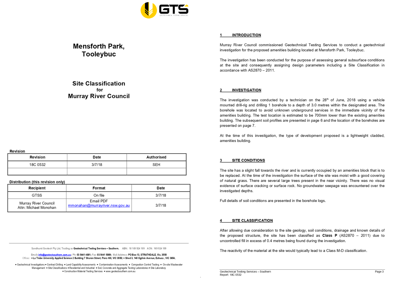
13.3 DEVELOPMENT
APPLICATION 040/18
File
Number: -
Author: Simon
Arkinstall, Director Planning & Environment
Authoriser: Simon
Arkinstall, Director Planning & Environment
Applicant: North
East Survey and Design
Owner: KA
CLARKE AND ML PAGE
Proposal: 37 LOT RESIDENTIAL SUBDIVISION
Location: lOT 1-17,19 & 20, DP702257; AND LOT 1,
DP1204160, WARDEN AND HOLMES STREET, MOAMA
|
Recommendation
That Development Application 040/18 for a
37 Lot Residential Subdivision at Lot 1-17, 19 & 20, DP702257
and Lot 1, DP1204160 (Warren and Holmes Street, Moama) be approved, subject
to the conditions of consent, as referred to in the report.
|
Background
This report is prepared for Council’s
consideration as a result of a rescission motion being resolved by Council.
The report was initially presented to Council for
consideration at its extraordinary meeting of 24 October 2018. At this meeting
Council resolved:
RESOLVED that Development Application 040/18 for a 37 Lot
Residential Subdivision at Lot 1-17, 19 & 20, DP702257 and Lot 1, DP1204160
(Warren and Holmes Street, Moama) be deferred, subject to Council completing
the Flood Study and Stormwater Strategy for Moama.
The applicant raised concerns with respect to the
Council’s resolution and subsequently a number of Councillors met onsite
to discuss the potential concerns with Council officers. In addition
Council officers met separately with local residents that raised objections to
obtain a better understanding of the listed concerns, which related
predominantly to drainage.
Council at its meeting of 22 January 2019 adopted
the following rescission motion:
That: 1. Resolution number 351018 of the
Ordinary Meeting of Murray River Council of 24 October 2018 pertaining to the
Director Planning & Environment Report, Clause 1 – Development
Application 040/18), be rescinded. 2. Council: (a) Reconsiders Development
Application 040/18 for a 37 Lot Residential Subdivision at Lot 1-17, 19 &
20, DP702257 and Lot 1, DP1204160 (Warren and Holmes Street, Moama); and (b)
Seeks further details in relation to the management of stormwater impacts
resulting from the proposed development, as detailed at (a).
Council officers are submitting the assessment
report for Council consideration, where additional information will be provided
to address the drainage concerns.
Discussion
This report is structured to firstly provide an
overview of the proposed modified development and the statutory assessment
procedure used during processing the modified development application. An
assessment of the modified development application is then provided which
culminates in the recommendations.
This
report has been divided into the following structure:
Ø Section 1 –
Introduction: provides an introduction to the modified development
application and a basic description of the proposed modified development.
Ø Section 2 – Statutory
Assessment Process: describes the proposed statutory procedures used to
assess the modified development application.
Ø Section 3 – Assessment
of the Modified Application: identifies the relevant statutory and
strategic land use and development policies and guidelines applicable to the
modified development application and assesses the considered performance of the
modified development application against these policies and guidelines.
Ø Section 4 –
Recommendations: discusses the recommendations arising from the assessment
of the modified development application.
Ø Section 5 –
Proposed Conditions of Modified Development Consent
Subject
Site
The subject site is Lots 1-17, 19 and 20 in DP 702257 and Lot 1 in DP1204160, situated between Murray,
Warden, Winall and Holmes Streets, Moama NSW 2731. The site is zoned R1 General
Residential, and is mapped as Murray REP2 –Riverine Land but is not
located within an Urban Release Area. The subject site is mapped to contain
Terrestrial Biodiversity (Vegetation) and located within the Bush Fire mapping
area. No known items of environmental heritage significance are located on the
site or in the immediate vicinity of the site. The subject lot is approximately
4.033ha in area, which encompasses the entire proposed development.
The subject land is located to the eastern side of
the Moama urban area, with established dwellings being located immediately
adjacent in Murray Street. The subject land adjoins bushland to the north and
east, existing residential development to the west and existing residential /
commercial operation to the south.
The subject land contains a single shed in the
north west corner of the land, within current Lot 19. The area surrounding
the shed includes a small hardstand area, rural type fencing and associated
landscaping, including exotic species. The land is otherwise undeveloped and
presents to the area as a large urban lot with no other uses identified on the
land.
The property has been partially cleared for
residential and urban uses, however contains patches of vegetation,
particularly along Holmes Street frontage through the centre of the land and at
Warden Street. The vegetation is limited to River Red Gum and Box Trees, with
little understorey vegetation evident.
The topography of the site is flat, with gentle
fall to the south from Holmes Street across the site towards Warden Street. No
watercourses or other site features are noted on the property. The Murray River
environs are located some 300m south, with general landscape tending in that
direction.
Council Local Environmental Flood planning maps
does not encompass the site and the eastern boundary of the property is bounded
by the Moama town levee.
See Figure 1 for locality and Figure 2
for an aerial photo of the subject land.
Figure 1 -
Locality map

Figure 2 -
Aerial photograph of subject land

Proposal
The development application is for the demolition of the
existing buildings and structure, re-subdivision of the subject land into 37
residential lots, removal of vegetation and civil works associated with the
proposed subdivision. The components of the development application are
detailed below:
1. Demolition
– The demolition of the existing structures in the north west corner of
the land. This includes an existing shed, small ancillary building, timber
fence and associated landscaping.
2. Native
Vegetation Removal – It is proposed to remove 49 existing large
native trees and 76 smaller natives or exotic species from the property in
order to establish the new internal services and infrastructure and enable
suitable building envelopes for the new buildings on the proposed lots. The
majority of the vegetation to be removed is from within the lot boundaries and
includes River Red Gums and only two Box species.
Only
three trees are to be removed from the Warden Street road reserve and four
trees from Holmes Street, with access driveways proposed to each lot fronting
these streets in a form that will avoid the need for removal of significant
number of trees.
3. Subdivision
– The proposal seeks to re-subdivide the existing 20 lots into 37
residential lots and creation of a new public road. The development will be
arranged along a new internal cul-de-sac, with 16 lots accessed along the new
internal road. 8 lots are to address Holmes Street in the north and 13 lots to
address Warden Street. No lots will have their primary frontage to Murray
Street.
Proposed
lot sizes are generally large urban lots, however 7 lots addressing Warden
Street are proposed to be higher density ‘townhouse’ lots
approximately 500m2 in area. All other proposed lots will range
between 822m2 and 1.113m2.
It
is considered that all proposed allotments are appropriately designed and have
an appropriate allotment size. All lots, which form part of the proposal,
comply with the minimum lot size provisions affecting the land and will be able
to be fully serviced by all relevant services.
Figure 3 - shows the
proposed subdivision layout

Statutory Assessment Process
2.1 Environmental
Planning and Assessment Act 1979
Section 5 Objects
The objects of this Act are:
(a) to
encourage:
(i) the
proper management, development and conservation of natural and artificial
resources, including agricultural land, natural areas, forests, minerals,
water, cities, towns and villages for the purpose of promoting the social and
economic welfare of the community and a better environment,
Comment: It is considered that the proposed development is not
inconsistent with this object. The subject site is zoned R1 General Residential
which supports residential development. Noting that a number of native trees
will be required to be removed as a result of the proposed development.
(ii) the
promotion and co-ordination of the orderly and economic use and development of
land,
Comment: It is considered that the proposed development is not
inconsistent with this object. The proposed subdivision has the potential to
provide orderly and economic use and development of the subject site.
(iii) the
protection, provision and co-ordination of communication and utility services,
Comment: The proposed development is consistent with this
object.
(iv) the provision
of land for public purposes,
Comment:
The proposed development is
consistent with this object.
(v) the provision
and co-ordination of community services and facilities, and
Comment: The proposed development is considered not
inconsistent with this object.
(vi) the
protection of the environment, including the protection and conservation of
native animals and plants, including threatened species, populations and
ecological communities, and their habitats, and
Comment: It is considered that the proposed development does
not adversely affect upon the natural environment. A number of native trees
will be required to be removed as part of the proposed development to permit
the installation of required infrastructure and future buildings.
The
applicant has submitted a Threatened species assessment report that suggested
that native wildlife will be displaced as a result of the development but it is
questionable whether the loss of a small area of agriculture pasture with some
native vegetation would have a localised effect upon the long term survival of
threatened species of the Murray Fans sub bioregion.
(vii) ecologically
sustainable development, and
Comment: It is considered that the proposed development is not
inconsistent with this object.
(viii) the provision and
maintenance of affordable housing, and
Comment: The proposed subdivision has the potential to provide
the opportunity for affordable housing within Murray River Council.
(b) to
promote the sharing of the responsibility for environmental planning between
the different levels of government in the State, and
Comment: The
proposed development was notified to the required Governmental authorities, who
have issued their respective conditions of consent where applicable.
(c) to
provide increased opportunity for public involvement and participation in
environmental planning and assessment.
Comment: The application was notified to surrounding property
owners in accordance with legislation and Council’s Notification Policy.
Six public submissions were received. These submission are outlined latter in
this report.
Section 5A
Comment: the Applicant had
a threatened species impact assessment completed which concluded:
“the property currently
provides habitat for more common indigenous bird species. Whilst, threatened
bird species were not recorded on the property on the day of the survey, the
property could nevertheless provide habitat for some threatened species. The
only way to determine if the property is frequented by threatened species is
for a series of repeat surveys to be completed.
It is questionable whether the
loss of a small area of agricultural pasture and some native vegetation would
have localised adverse effect upon the long-term survival of threatened species
of the Murray Fans sub-bioregion. In addition, the loss of the approximately 4
hectares of farmland with remnant vegetation to residential development would
not cause further fragmentation of the vegetation as the current eastern
boundary of urban Moama., which currently ends on the western side of Murray
Street would be pushed to the eastern side of Murray Street. Nevertheless, the
loss of native vegetation and exotic pasture will be further decrease in habitat
available to more common species of indigenous birds that can utilise a pasture
agricultural landscape and possibly some listed threatened species of wildlife.
Native wildlife will be displaced by the development of the property into
residential housing.”
It is considered that the proposed
development is unlikely to have a significant effect on threatened species,
populations or ecological communities, or their habitats. No identified
threatened species, populations or ecological communities, or their habitats
were located on the subject land through the threatened species survey.
Section 79BA
Comment: Not
applicable. The application is for a residential subdivision.
Section 91 - Integrated Development
Comment: the site is mapped as bushfire prone and as a result
Section 100B of the Rural Fires Act 1997 requires that a Bush Fire Safety
Authority be issued by the NSW RFS for development classified as special fire
protection purposes. As a result, the application was referred to the NSW RFS for
comment as the development was deemed integrated.
Figure
5 - Bush Fire Prone Land mapping
2.2 Chronology
of Events and Public Notification and Statutory Referral Process Application
History/Timeline
|
Application lodged and fees paid
|
20 February 2018
|
|
DA Panel
|
13 March 2018
|
|
Further information requested
|
22 March 2018
|
|
Further information received
|
16 April 2018
|
|
Referred to Engineering Department for initial comment
|
18 May 2018
|
|
Public Notification
|
18 May 2018
|
|
Referral under REP2
|
18 May 2018
|
|
Integrated development notification
|
18 May 2018
|
|
Forwarding submission to applicant
|
26 June 2018
|
|
Requests from Planning Department to Engineering
Department to clarify comments
|
10 July 2018
|
|
Integrated response received from NSW RFS
|
31 July 2018
|
|
Additional information from applicant provided (address
OEH requirements)
|
2 August 2018
|
|
OEH comments referred to applicant
|
22 August 2018
|
|
Applicant response to address OEH concerns
|
29 August 2018
|
|
OEH response
|
31 September 2018
|
|
Report completed
|
16 October 2018
|
|
Report Considered by
Council
|
|
|
Rescission motion
|
|
2.3 Referrals
and Owners Consent
|
Internal Referrals
|
· DA Panel
· Engineering
Department
|
|
External Referrals
|
· NSW RFS
· NSW Department
of Primary Industry – Fisheries
· NSW
Environmental Protection Authority
· NSW Office of
Environment and Heritage
· NSW National
Parks and Wildlife Service
· Murray Darling
Basin Association
· NSW Department
of Industry – Natural Resources Access Regulator (Water)
· NSW Department
of Industry – Crown Lands
· Water NSW
· Forestry
Corporation NSW
|
|
Advertised
|
Placed in media
|
|
Public Notification
|
Adjoining property owners were notified
|
|
Owner’s Consent
|
Provided
|
2.4 Contributions
Section 64 charges and Section 94
Development Contributions are required for the additional
residential allotments proposed to be created.
Town Planning Assessment
Assessment of the modified development application has been
undertaken in respect to relevant considerations arising from Section 14.5 of
the Environmental Planning and Assessment Act 1979 as follows:
3.1 Section
14.5 Evaluation
(1) Matters for consideration-general
In
determining a development application, a consent authority is to take into
consideration such of the following matters as are of relevance to the development
the subject of the development application:
(a) the provisions of:
(i) any environmental planning instrument, and
(ii) any proposed instrument that is or has been the subject of
public consultation under this Act and that has been notified to the consent
authority (unless the Director-General has notified the consent authority that
the making of the proposed instrument has been deferred indefinitely or has not
been approved), and
(iii) any development control plan, and
(iiia) any planning agreement that has been entered into under section
93F, or any draft planning agreement that a developer has offered to enter into
under section 93F, and
(iv) the
regulations (to the extent that they prescribe matters for the purposes of this
paragraph), and
(v) any
coastal zone management plan (within the meaning of the Coastal Protection Act 1979),
that
apply to the land to which the development application relates,
(b) the likely impacts of that development, including
environmental impacts on both the natural and built environments, and social
and economic impacts in the locality,
(c) the suitability of the site for the development,
(d) any submissions made in accordance with this Act or the
regulations,
(e) the public interest.
3.2 Section
14.5 Evaluation – (1)(a) The Provisions
3.2.1 Section 14.5 Evaluation – (1)(a)(i)
Environmental Planning Instruments:
Ø Murray
Local Environmental Plan 2011
Part 1 Preliminary
Clause 1.2 Aims of Plan
(1) This
Plan aims to make local environmental planning provisions for land in Murray in
accordance with the relevant standard environmental planning instrument under
section 33A of the Act.
Comment: Noted.
(2) The
particular aims of this Plan are as follows:
(a) to encourage sustainable economic growth and
development within Murray,
Comment: It is considered that the proposed development is not inconsistent with this aim. The
proposed subdivision has the potential to provide economic growth and
development within Murray River Council by providing additional residential
allotments for future development.
(b)
to encourage the retention of productive rural land in agriculture,
Comment:
The proposed development complies with this aim with the subject site is zoned
R1 General Residential and therefore is zoned for residential purposes.
(c)
to identify, protect, conserve and enhance Murray’s natural assets,
Comment:
The proposed development does not adversely impact Murray’s natural
assets.
(d) to
identify and protect Murray’s built and cultural heritage assets for
future generations,
Comment:
The subject site does not contain any known items of environmental heritage
significance.
(e)
to allow for the equitable provision of social services and facilities for the
community,
Comment:
The proposed modification is considered to be consistent with this aim.
(f)
to encourage and focus growth in the Moama and Mathoura townships,
Comment:
The proposed development is consistent with this aim. The subject site is zoned
R1 General Residential and is located within the Moama township.
(g) to
provide for future tourist and visitor accommodation in a sustainable manner
that is compatible with, and will not compromise, the natural resource and
heritage values of the surrounding area.
Comment:
Not applicable. The proposed development is a residential
subdivision.
Clause 1.9 A Application of
covenants, agreements and instruments
Comment: For the purpose of enabling development on land in
any zone to be carried out in accordance with this Plan or with consent granted
under the Act, any agreement, covenant or other similar instrument that
restricts the carrying out of that development does not apply to the extent
necessary to serve that purpose.
Part 2 Permitted or
prohibited development
Clause 2.3 Zone objectives
and Land Use Table (development permissibility)
The land is zoned R1 General
Residential.
The objectives of this zone
are;
· To provide for the housing needs of the community.
· To provide for a variety of housing types and densities.
· To enable other land uses that provides facilities or services to
meet the day to day needs of residents.
· To avoid potential land use conflict and protect the amenity of
residents.
· To provide for tourist and visitor accommodation in appropriate locations.
Comment: The proposed development is considered to be
consistent with the objectives of the zone. The proposed development continues
to provide for a variety of housing densities in Moama. The proposed lot size ranges from 500 m2
up to larger corner allotments of 1,000 plus m2 (max area 1,113m2)
The
proposed subdivision design continues to incorporate allotments that may result
in land use conflict with the commercial operation directly opposite the
proposed sites that front Warden Street. The business involves the operations
of cranes that may operate at extended hours of the day and night resulting in
potential noise conflict.
If
conflict were to result the commercial operator would be required to comply
with the NSW EPAs Industrial Noise Policy.
Permissibility:
The application is for the
subdivision of the subject land. Subdivision of land is permissible with
consent. See Clause 2.6 of this report for more information.
Clause 2.4 Unzoned land
Comment: not applicable
Clause 2.5 Additional permitted uses for particular land
Comment: not applicable
Clause 2.6
Subdivision—consent requirements
Comment: The Applicant has applied for Council consent for
the proposed development.
Clause
2.7 Demolition requires development consent
Comment: The application involves the demolition of existing
buildings which form part of the application.
Clause
2.8 Temporary use of land
Comment: Not
applicable.
Part
3 Exempt and complying development
Clause
3.1 Exempt Development
Comment: The application does not meet the requirements to be
classed as exempt development, therefore a development application is required.
Clause
3.2 Complying Development
Comment: The application does not meet the requirements to be
classed as exempt development, therefore a development application is required.
Clause
3.3 Environmentally sensitive areas excluded
Comment: Noted – not applicable as development is
neither exempt of complying
Part 4 Principal
development standards
Clause 4.1 Minimum
subdivision lot size
Comment: All allotments forming part of the proposed modified
subdivision are equal to or above 450m², which is the minimum size
outlined on the lot sizes map.
Clause 4.1AA Minimum
subdivision lot size for community title schemes
Comment: Not applicable.
Clause 4.1A Minimum
subdivision lot size for strata plan schemes in certain rural, residential and
environmental zones
Comment: Not applicable.
Clause 4.1B Minimum
subdivision lot sizes for certain split zones
Comment: Not applicable.
Clause 4.2 Rural Subdivision
Comment: Not applicable.
Clause 4.2A Erection of
dwelling houses on land in certain rural and environmental protection zones
Comment: Not applicable.
Clause 4.2B Rural
workers’ dwellings
Comment: Not applicable.
Clause 4.2C Exceptions to minimum lot sizes for certain
rural subdivisions
Comment: Not applicable
Clause 4.2D Boundary adjustments in Zones RU1 and E3
Comment: Not applicable
Clause 4.3 Height of
buildings
[Not
adopted]
Clause 4.4 Floor Space Ratio
[Not
adopted]
Clause 4.5 Calculation of
floor space ratio and site area
[Not
adopted]
Clause 4.6 Exceptions to
development standards
Comment: Not applicable.
Part 5 Miscellaneous
provisions
Clause 5.1 Relevant
acquisition authority
Comment: Not applicable.
Clause 5.2 Classification
and reclassification of public land
Comment: Not applicable.
Clause 5.3 Development
near zone boundaries
Comment: Not applicable.
Clause 5.4 Controls
relating to miscellaneous permissible uses
Comment: Not applicable.
Clause 5.5 Development
within the coastal zone
[Not
applicable]
Clause 5.6 Architectural
roof features
[Not
applicable]
Clause 5.7 Development below
mean high water mark
[Not
applicable]
Clause 5.8 Conversion of fire
alarms
Comment: Not applicable
Clause 5.9 Preservation
of trees or vegetation
Repealed.
Clause 5.9AA Trees
or vegetation not prescribed by development control plan
Repealed.
Clause 5.10 Heritage
Conservation
Comment: The subject site does not contain any known items of
environmental heritage significance, and there are no known items of
environmental heritage significance in the immediate vicinity.
The
Applicant completed a AHIMS survey and completed the required process as
detailed in the Due Diligence Code of Practice for the Protection of Aboriginal
Objects and such did not reveal or identify any heritage items or conservation
areas, or any Aboriginal place of heritage significance on the subject land.
Clause 5.11 Bush fire hazard reduction
Comment: Noted.
Clause 5.12 Infrastructure development and use of existing buildings of the Crown
Comment: Not applicable.
Clause 5.13 Eco-tourist
facilities
Comment: Not applicable.
Clause 5.14 Siding Spring Observatory—maintaining dark sky
[Not adopted]
Clause 5.15 Defence communications facility
[Not adopted]
Part 6 Urban Release Areas
Comment: The land is not located within the mapped Urban
Release Area.
Part 7 Additional local
provisions
Clause 7.1 Essential Services
Development
consent must not be granted to development unless the consent authority is
satisfied that any of the following services that are essential for the
proposed development are available or that adequate arrangements have been made
to make them available when required:
|
Subclause
|
Comment
|
|
(a) the supply of water,
|
· All allotments will be connected to Council’s existing
filtered water system.
· The raw water main will be required to be extended at the expense
of the developer and such will be incorporated into the conditions of
consent, if approval is granted.
|
|
(b) the supply of
electricity,
|
· Electricity is available. Any extension or connection of services
will be required to be completed by the developer and at the developers
expense.
|
|
(c) the disposal and
management of sewage,
|
· All proposed allotments will be required to connect to
Council’s sewer and this will required the extension of the existing
infrastructure. The sewer mains will be required to be extended at the
expense of the developer and such will be incorporated into the conditions of
consent, if approval is granted.
· The sewer is proposed to be run parallel and inside the adjoining
levee to connect into Council’s infrastructure in Council Street.
|
|
(d) stormwater
drainage or on-site conservation,
|
· Stormwater will be managed in accordance with the Engineering
Department requirements. Stormwater will be piped into the existing
infrastructure positioned within Murray Street.
· Council’s Engineering Department have reviewed all
documentation and have no objection to the proposed stormwater management
proposal. All required works will be at the expense of the developer.
|
|
(e) suitable road access
|
· The access to the development site will be off Murray Street. The
developer proposes to obtain internal access via a cul-de-sac. Council is
advised that this proposal does not meet the requirements of Council’s
DCP, however the applicant has provided justification as to why the
cul-de-sac option is preferred.
· The two main restrictions on the design as advised by the
developer relate to the levee along the eastern property boundary and the
native vegetation that lines the road reserve to the north and south of the
property. Because of these constraints that developer has opted for the
cul-de-sac thus minimising the disturbance of the native vegetation within
the road reserves.
|
Clause 7.2 Earthworks
Comment: The modified application is not
inconsistent with this clause. It is considered that any earthworks required
are ancillary to the subdivision of land in which the Applicant is applying for
consent. Any development consent will be appropriately conditioned to protect
the environment.
Clause 7.3 Biodiversity
Protection
Comment: The subject land is covered by
Council’s biodiversity mapping and as a result, the application was
referred to NSW OEH for comment.
To
minimise the impact of the development on the native vegetation Council will
require the developer to undertake an arborist’s assessment of all trees
with a 200mm DBH and on completion of same the developer will be required to
implement the recommendations of the report at their expense.
The
initial OEH response resulted in the applicant being required to prepare a
threatened species assessment by a consulting ecologist. In summary, the
threatened species impact assessment concluded:
‘the
property currently provides habitat for more common indigenous bird species.
Whilst, threatened bird species were not recorded on the property on the day of
the survey, the property could nevertheless provide habitat for some threatened
species. The only way to determine if the property is frequented by threatened
species is for a series of repeat surveys to be completed.
It
is questionable whether the loss of a small area of agricultural pasture and
some native vegetation would have localised adverse effect upon the long-term
survival of threatened species of the Murray Fans sub-bioregion. In addition,
the loss of the approximately 4 hectares of farmland with remnant vegetation to
residential development would not cause further fragmentation of the vegetation
as the current eastern boundary of urban Moama., which currently ends on the
western side of Murray Street would be pushed to the eastern side of Murray
Street. Nevertheless, the loss of native vegetation and exotic pasture will be
further decrease in habitat available to more common species of indigenous
birds that can utilise a pasture agricultural landscape and possibly some
listed threatened species of wildlife. Native wildlife will be displaced by the
development of the property into residential housing.’
In
reviewing the documentation, it is suggested that the Ecologist is indicating
that there were no threatened species noted on site, however such advice may be
limited based on the length of the study and a true impact can only be
determined by increasing the length of the survey.
The report also indicated that the true impact of the
proposed development would be more aligned to displacing native wildlife.
Figure 6 – Biodiversity overlay (vegetation)

Figure 6 indicates that the mapped biodiversity is
predominantly located within Council’s road reserves and along the levee.
The Applicant has indicated that the retention of the additional native
vegetation on the site will ensure retention of habitat for native fauna. The
development through design has already retained the significant communities of
Grey Box Trees located in the northern and southern road reserves of the site.
Given that the property is zoned for residential use, it is considered that the
design provides a balance achieving sustainable development.
To protect this vegetation it will be proposed to
install a 5-meter buffer / easement within the subject site parallel and
adjacent to Holmes, Warden and Winall Streets. This buffer is deemed necessary
to ensure Council has access to maintain these trees as they grow and the site
becomes developed. Experience has indicated that as dwellings are constructed
and yards developed that there is an expectation by the land owners that
Council will maintain the vegetation within its road reserves. This buffer /
easement enables Council to access the sites to undertake the required works.
Note that Council has required subdivisions of a
similar nature to implement same.
Council is also advised that the study was referred to
NSW OEH did not provide any objection to the final design and documentations as
submitted by the Applicant.
Clause 7.4 Development on
river front areas
Comment: Not applicable. The subject land
is not located in a river front area.
Clause 7.5 Riparian
land and Murray River and other watercourses-general principles
Comment: Not applicable. The subject land
is not located on riparian land.
Clause 7.6 Additional
provisions-development on river bed and banks of the Murray and Wakool Rivers
Comment: Not applicable. No development is proposed on the river bed and banks
of the Murray or Wakool Rivers.
Clause 7.7 Wetlands
Comment: Not applicable. The subject land is not mapped as Wetlands.
Clause 7.8 Flooding
(1)
The objectives of this clause are as follows:
(a) to
minimise the flood risk to life and property associated with the use of land,
(b) to
allow development on land that is compatible with the land’s flood
hazard, taking into account projected changes as a result of climate change,
(c) to
avoid significant adverse impacts on flood behaviour and the environment.
Comment: It is considered that the proposed development is consistent with the
objectives of the clause based on the site being protected by the levee.
Schedule 1
Additional permitted uses
Comment: Not
applicable.
Schedule
2 Exempt development
Comment: Not
applicable.
Schedule
3 Complying development
Comment: Not
applicable.
Schedule
4 Classification and reclassification of
public land
Comment:
Noted.
Schedule
5 Environmental heritage
Comment:
Noted.
Ø Murray Regional Environmental Plan 2 – Riverine Land
Comment: The
subject site is mapped as Murray Regional Environmental Plan 2 – Riverine
Land.
Figure 7 – Murray REP2 Riverine Land mapping

Part 1 Introduction
Clause 2 Aims of the plan
Comment: The proposed development is considered to not be
inconsistent with the aim of Murray REP 2. The proposed development will help
to conserve and enhance the riverine environment of the River Murray for the
benefit of all users as it is set back from the river and storm water will be
managed through existing infrastructure and discharging into a wetland system
prior to entering the river.
Clause 3 Objectives of the plan
Comment: The proposed development is considered to be not
inconsistent with the objectives of Murray REP 2. The proposed development will
not adversely affect the riverine environment of the River Murray as it is set
back some 300 meters from same.
Clause 4 Where
the plan applies
Comment: Noted.
Clause 5 How this plan affects other plans
Comment: Noted.
Part 2 Planning principles
Clause 8 When planning principles should be applied
Comment: Noted.
Clause 9 General principles
Comment: The proposed development is considered to be
consistent with the general principles of Murray REP 2.

Chapter 7
Subdivision
Comment: It
is noted that the proposed development is consistent with the layout, staging
or design of the proposed subdivision.
|
Subchapter
|
Objectives
|
Controls
|
Comment:
|
|
7.1
Context
|
Consistent
|
Partially Consistent
|
· The proposed layout and lot design of the
subdivision are considered to be consistent with the objectives of the
subchapter, and suitable for its context.
|
|
7.2 Neighbourhood Character
|
Consistent
|
Consistent
|
· The proposed subdivision is generally consistent and
compatible with the theme and neighbourhood character of the area. The
development surrounding the site to the north-west and west incorporates a
high density residential nature. The development to the east is separated
from the site by the Moama Flood Levee and incorporates residential
development of rural in nature.
· The development to the south of the site is
commercial in nature and there is the potential for this to create conflict
based on the types of activity. The main potential concern would be based
around noise and the impact that such may have on the amenity of potential
future residential properties.
· The impact of the commercial development on existing
residential properties does not appear that great and there is the potential
that both can co-exist.as is the current scenario in the event that noise
complaints are received from future residential property owners the
commercial operation will be required to adhere to the NSW EPA Industrial
Noise Policy.
|
|
7.3
Staging
|
Consistent
|
Consistent
|
· The development does not incorporate staging.
|
|
7.4
Movement Network
|
Consistent
|
Consistent
Inconsistent
|
· The proposed movement network as part of the
proposed development promotes easy movement for vehicles and pedestrians. The
proposed subdivision will provide a central cul-de-sac connecting to Murray
Street.
· Access to a number of residential properties will be
provided directly off both Warden and Holmes Streets.
· The proposed subdivision will be required to provide
for pedestrian and cycle movement along Murray Street. Additional path
networks have not been provided along Warden and Holmes Streets due to the
potential impacts on the existing native vegetation.
· A cul-de-sac is proposed and the applicant has
indicated that such was unavoidable due to the constraints placed on the
development by the native vegetation in the road reserves along Warden and
Holmes Streets. If a through road was installed in a north – south
direction it would result in the loss on significant native vegetation both
on the road reserves and within the property. A through road cannot be design
in the east – west direction as the site is constrained by the Moama
Flood Levee. Council’s Engineering Department did not raise any
concerns with respect to the cul-de-sac from a traffic movement perspective.
· Even though the cul-de-sac does not directly meet
the requirements of Council’s DCP it would not appear to create any
significant issue to warrant refusal based around the justification.
|
|
7.5
Activity Centres and
Community Facilities
|
Consistent
|
Consistent
|
· Not applicable. The land is not identified by
Council’s Strategic Land Use Plan or Moama North West Masterplan for
use as an Activity Centre or Community Facility.
|
|
7.6
Public Open Space
|
Consistent
|
Consistent
|
· The proposed subdivision will not provide any open
space.
· The Applicant has indicated that public open space
is not required based on the following:
- already existing 20 lots and therefore only creating
an additional 17 lot and thus under the 25 lot threshold,
- close proximity to the Murray River and associated
Reserve,
- creating a path network and connection to the levee
bank.
|
|
7.7
Landscaping
|
Consistent
|
Consistent
|
· Preliminary details have been provided in
correspondence in respect to landscaping. Any development consent will
include a condition of consent requiring a detailed landscaping plan to be
prepared and submitted prior to the release of the Construction Certificate.
|
|
7.8
Lot Design
|
Consistent
|
Consistent
|
· The proposed subdivision is deemed consistent with
the objectives of the subchapter. The proposed allotments provide sufficient
room for the construction of dwelling houses which are appropriately sited,
whilst allowing for solar access, private open space, vehicle access and
parking.
· The proposed allotment design is satisfactory and
comprises mainly rectangular allotments that promote the objectives of this
section. All proposed allotments are able to contain a 10m by 15m building
envelope if such were required.
|
|
7.9 Infrastructure and
Services
|
Consistent
|
Partially Consistent
|
· Preliminary engineering plans were submitted with
the application which Council’s Engineering Department have considered
to be satisfactory. Preliminary details have been discussed under Clause 7.1
of Murray LEP 2011 within this report. Further investigation and engineering
details will be required prior to the release of any Construction Certificate
which will form a condition of development consent.
|
|
7.10
Natural Hazards
|
Consistent
|
Consistent
|
· A portion of the lots are mapped as bush fire prone
and as a result the application was referred to the NSW RFS.
· The NSW RFS responded with no objections and issuing
their GTAs.
|
|
7.11
Site Management
|
Consistent
|
Consistent
|
· The proposed subdivision is consistent with this
subclause. Stormwater Management and Sediment Erosion Control Plans will be
required in accordance with any development consent issued.
|
Chapter 9 Vegetation Removal
Comment:
Vegetation is proposed to be removed as part of the proposed development. As
indicated previously within this assessment a Threatened Species Impact
Statement was prepared and submitted for consideration. The applicant also
provided addition information in response the OEH concerns. After reviewing all
information the OEH did not object to the proposed development proceeding.
Council is advised that the proposed development will
affect the native vegetation located within Council’s road Reserve, in
particular in Holmes and Warden Streets. This impact will result due to access
being required to the proposed residential lots that face/access directly onto
these streets. The developer has positioned the access roads in an attempt to
minimise the impact on the tree root zones.
There
are two other considerations for Council in relation to the vegetation located
within the road reserves, these being:
(a) Initial
removal and pruning: the development will result in a number of trees to be
removed and / or pruned. To ensure that this is undertaken in an approved
manner there will be the requirement for an arborist assessment to be
undertaken on all trees with a 200mm DBH. This will ensure that only suitable
trees will be removed and that all trees will be made safe through appropriate
pruning.
(b) Ongoing
maintenance will be required to be undertaken on the trees to reduce risk on
future properties. This type of activity is required to be undertake by Council
on other residential subdivisions within Moama where native vegetation sits
adjacent to residential property boundaries. To enable this maintenance to
occur a 5 meter buffer/easement will be required along Holmes and Warden
Streets and the levee boundary to ensure Council has access to complete the
required works. This process has been conditioned on similar subdivision
approvals within Moama.
To
ensure the ratepayer is not burdened with the cost for assessing, pruning
and/or removing the trees such cost should be borne by the developer through a
condition of consent.
Chapter
11 Flood Prone Land
Comment: The
subject land is not mapped as Flood Prone Land under the Murray LEP 2011;
however, it is also protected by the Moama Town Flood Levee.
Chapter 12 Notification
Comment: The modified application was notified to relevant
agencies and adjoining property owners in accordance with this plan. Six (6)
public submissions were received (attached as Appendix).
3.2.4 Section 14.5 Evaluation – (1)(a)(iiia) Any Planning Agreements:
Comment: No planning agreements exist on the subject site.
3.2.5 Section
14.5 Evaluation – (1)(a)(iv) The Regulations:
Comment: The
regulations have been considered during the assessment of this development
application.
Council’s Section 7.11 Development Contributions
Plan 2011 was adopted and reviewed in accordance with the Environmental Planning and Environment Act 1979 and
Regulations. It is considered that the requirement for payment of Section 7.11
Contributions is to be implemented.
3.2.6 Section
14.5 Evaluation – (1)(a)(v) Coastal Zone Management
Plan:
Comment: Not
applicable.
3.3 Section 14.5 Evaluation
– (1)(b) The Likely Impacts of that Development,
Including Environmental Impacts on Both the Natural and Built Environments, and
Social and Economic Impacts in the Locality:
3.3.1 Environmental Impacts
Natural
Environment
· Native
Vegetation: The Applicant does propose to remove native vegetation as detailed
elsewhere in this report.
· Threatened
Species: It is considered that the proposed development will not have any
adverse impact on threatened species. This matter has been addressed through
the development of a Threatened Species Impact Assessment plus OEH raising no
objections. This has been discussed previously throughout this assessment
report.
· Fauna:
It is considered that the proposed development will not have any adverse impact
on native fauna. The subject land does not contain any significant native
vegetation or habitat and adjoins existing urban development.
· Bushfire:
The subject land is mapped as Bush Fire Prone Land and the NSW RFS have
provided their GTAs.
· Flooding:
The subject land is not mapped as Flood Prone Land.
· Soil:
The subject land is unaffected by severe salinity, erosion, acid sulphate,
subsidence, water logging or unstable land.
· Air:
The proposed development is not expected to have any unreasonable impacts on
air quality. Any development consent will be appropriately conditioned to
ensure that during construction appropriate measures are implemented to control
dust.
· Landscaping:
Preliminary details have been provided in correspondence in respect to
landscaping. A condition of consent requires a detailed landscaping plan
to be prepared and submitted.
Built Environment
· Built
Heritage: The subject land does not contain any known items of environmental
heritage significance, whilst no known items of environmental heritage
significance adjoin the subject land.
· Indigenous
Heritage: The subject land is not known to contain any sites or artefacts
of Indigenous heritage significance. The subject land has been disturbed for
many years and it likely that any Indigenous heritage that did once exist has
already been disturbed by human activity. The applicant has also completed an
AHIMS, which did not reveal Aboriginal places within the subject land.
· Character:
The character of the area is represented by a high-density residential feel to
the North West and west. To the east is a rural residential property with development
restricted by the flood plain. To the south is residential development, however
the property immediately opposite on Warden Street is a residential dwelling
and commercial operation. The proposed residential development attempts to
ensure compatibility with this existing character by proposing lots of a
similar size to that with the R1 zone.
· Traffic:
The proposed subdivision of 37 residential allotments will result in an
increase in traffic/vehicle movements. It is envisaged that this will generate
approximately 297 additional vehicle trips daily on the surrounding roads. It
is considered that the existing road network will be able to cater for the
additional traffic generated by the proposed modified development. The proposed
design of this road network is considered satisfactory subject to more detailed
design plans being prepared in accordance with Council’s standards. There
are also pedestrian and cycle paths proposed to link the proposed modified
subdivision to the surrounding township and communities facilities, which is
considered an appropriate outcome.
Social Impacts
The proposed development is not expected to create any detrimental social
affects. The proposed subdivision is to be another residential estate, which
will provide a further supply of residential land within Moama. The proposed
residential estate will be well connected and integrated with the existing
community.
Economic Impacts
The proposed development is not expected to create any detrimental
economic affects. The proposed development has the potential to create positive
economic impacts through the construction of the subdivision and the subsequent
construction of dwelling houses erected within the subdivision subject to
separate development consent.
3.4 Section 14.5 Evaluation
– (1)(c) The Suitability of the Site for the
Development:
Comment: The subject land is considered suitable for the proposed residential
development. The subject site has been strategically identified for future
residential development in Council’s Strategic Land Use Plan, which was
reflected in the preparation of the Murray LEP 2011. The proposed development
reflects the identified strategy and statutory land use. The design of the
proposed subdivision aims to integrate with possible future residential
development to the east of Moama.
3.5 Section 14.5
Evaluation – (1)(d) Any Submissions Made in
Accordance with this Act or the Regulations:
3.5.1
|
NSW Rural
Fire Service
|
No objection
and GTA
|
|
OEH
|
No objection
and GTA
|
|
NSW
Environmental Protection Authority
|
No objection
and GTA
|
|
Murray-Darling
Basin Authority
|
No objection
|
|
NSW
Department of Primary Industry - Fisheries
|
No objection
and GTA
|
|
Water NSW
|
No objection
and GTA
|
|
NSW Office of
Environment & Heritage
|
No response
|
|
NSW National
Parks & Wildlife Service
|
No response
|
|
Murray
Darling Association
|
No response
|
|
NSW
Department of Industry – Natural Resources Access Regulator (Water)
|
No objection
|
|
NSW
Department of Industry – Crown Lands
|
No response
|
|
Forestry
Corporation NSW
|
No response
|
3.5.2 Public Submissions
Six
(6) public submissions were received and are outlined in the below table.
|
Submission No.
|
Submission
|
Comment
|
|
1.
|
· Concern regarding natural watercourse and limited plans detailing
drainage and waste water from the development and impact on neighbours.
· If addressed, no objection.
|
The applicant has submitted a stormwater feasibility
study, which was assessed by Council’s Engineering Department and
deemed satisfactory.
|
|
2.
|
· Objection based on lack of detail on flood, stormwater details.
· The current drainage system does not manage stormwater run-off
during heavy rain events.
|
The applicant has submitted a stormwater feasibility
study which was assessed by Council’s Engineering Department and deemed
satisfactory.
|
|
3.
|
· Impact of stormwater/drainage on our property. The water builds up
and there is a need to clear blocked drains in order to disperse the water,
which can take days.
|
The applicant has submitted a stormwater feasibility
study which was assessed by Council’s Engineering Department and deemed
satisfactory.
|
|
4.
|
· Impact on neighbouring properties appears not to have been
considered, especially from a run-off event.
- Clearance
of vegetation will increase run-off
- Increasing
housing density will increase run-off
- Building
up of blocks, associated roads and gutters will increase run-off and impact
on our property
- Drainage
design for Catchment B does not appear to recognize drainage is not confined
to underground pipes. Potentially lead to flooding impacts of our property.
|
The applicant has submitted a stormwater feasibility
study which was assessed by Council’s Engineering Department and deemed
satisfactory.
|
|
5.
|
· Discusses drainage pattern prior to the construction of the levy
– concerns relating to stormwater runoff .
|
The applicant has submitted a stormwater feasibility
study which was assessed by Council’s Engineering Department and deemed
satisfactory.
|
|
6.
|
Issues as
follows:
· When purchased property 3 months ago led to believe only 20 lots
by agent, which is now false.
· Removal of native vegetation.
· Increase from 20 to 37 lots compound matters, object no formal
planning, matter rushed and commune housing.
· No feasibility study in relation to impact on schools, services
and special schools.
· Traffic increase, rubbish dumping.
· Lack of letter sent out by Council and lack of signage.
· Impact on neighbouring business.
· No objection to 20 block.
|
Noted, not a planning consideration
Considered in assessment, in addition OEH raised no
objections.
Council completed strategic review in 2011, which
reconfirmed land, be zoned for residential purposes.
Noted, impact of an
additional 17 residential houses on services not deemed detrimental.
Traffic infrastructure considered capable of
managing additional traffic by Council’s Engineering Dept.
Illegal dumping of waste not a planning
consideration.
Notification undertaken in accordance with
Council’s DCP requirements.
Potential for conflict especially from noise
perspective and as indicated above from a stormwater management perspective.
Noted.
|
3.6 Section 14.5
Evaluation – (1)(e) The Public Interest:
Comment: The public’s interest has been considered
throughout the assessment of this development application under Section 14.5 of
the Environmental Planning and Assessment Act 1979. In this instance it
is considered that the proposed development is consistent with the public
interest.
3.7 Summary
Comment: The application has been assessed in accordance with
the considerations of Section 14.5 of the Environmental Planning and
Assessment Act 1979. The
proposed layout and lot design of the subdivision, development of a
further 37 residential lots, the construction
of roads and associated
infrastructure is considered appropriate
and in line with Council’s Murray LEP 11, strategic land use plan and
DCP.
As such, it is recommended that development consent be
granted for the proposed development subject to appropriate conditions of
modified development consent.
Section 4: Recommendations
It is recommended
that Development Application 040/18 for a 37 Lot Residential Subdivision at
Lot 1-17, 19 & 20, DP702257 and Lot 1, DP1204160 (Warren and
Holmes Street, Moama) be approved, subject to the conditions of consent, as
referred to in Section 5 (Conditions of Consent) of this Report.
Section 5: Conditions of Consent
Conditions
Prescribed by the Environmental Planning and Assessment Regulation 2000 That
Must be Fulfilled
(A) Prescribed Conditions of Development Consent in
Accordance with Division 8A of the Environmental Planning and Assessment
Regulation 2000 That Must be Fulfilled
· Clause 98: Compliance
with Building Code of Australia and insurance requirements under the Home
Building Act 1989
· Clause 98A: Erection
of signs
· Clause 98B:
Notification of Home Building Act 1989 requirements
· Clause 98C: Conditions
relating to entertainment venues
· Clause 98D: Condition
relating to maximum capacity signage
· Clause 98E: Condition
relating to shoring and adequacy of adjoining property
Please refer to the NSW State
legislation for full text of the clauses under Division 8A of the Environmental
Planning and Assessment Regulation 2000. This can be accessed at http://www.legislation.nsw.gov.au.
Reason: Prescribed by the Environmental Planning and
Assessment Regulation 2000.
General Conditions
That Must be Fulfilled
1. Approved plans
The
subdivision must be carried out in accordance with the following approved
preliminary plans and information submitted to and approved by Council except
where Council has been notified and consented to any amendments:
(a) Development Application Murray, Warden and Holmes
Street, Moama 37 lot subdivision and removal of vegetation prepared by Habitat
Planning (Dated February 2018)
(b) Bushfire Assessment Report Murray, Warden
and Holmes Street, Moama 37 lot subdivision and removal of vegetation prepared
by Habitat Planning (Dated February 2018)
(c) Estate 2731, Moama Landscape Master Plan Drawing
No M6166 (Sheets 1 and 2) (dated 12/02/2018) prepared by North East Survey
Design
(d) Estate 2731, Moama Landscape Concepts Drawing No
M6166 (dated 12/02/2018) prepared by North East Survey Design
(e) Service Plan 37 Residential (R1) Subdivision
Estate 2731 Moama Drawing No 6166(dated 05/02/2018) prepared by North East
Survey Design
(f) ODP Plan 37 Residential (R1) Subdivision Estate
2731 Moama Drawing No 6166(dated 05/02/2018) prepared by North East Survey
Design
(g) Storm Water & Sewer Feasibility Report
– Murray Street, Moama prepared by North East Survey Design
(h) Threatened Species Assessment at 28 Murray
Street, Moama (dated July 2018) prepared by Bill (W.E.) Richdale: Consulting Ecologist.
Reason:
To ensure that the development is carried out as assessed and advertised.
2. Engineering Guidelines for Subdivisions and Development Standards
The
developer must comply with
Council’s Engineering Guidelines for Subdivisions and Development Standards in conjunction with the advice from
Council’s Engineering Department.
Reason:
To ensure that the subdivision is carried out in accordance with
Council’s Subdivision Development Requirements.
3. Water supply work, sewerage work and stormwater
drainage work
Water
supply work or sewerage work that is plumbing and drainage work within the
meaning of the Plumbing and Drainage Act 2011 must comply with that Act
and the regulations under that Act. Any water supply work or sewerage work that
is not plumbing and drainage work under that Act, and any stormwater drainage
work, must comply with the Plumbing Code of Australia.
Reason: Council and Statutory requirement of Local
Government (General) Regulation 2005.
4. Aboriginal
Cultural Heritage
If any Aboriginal object is discovered
and/or harmed in, or under the land, while undertaking the proposed development
activities, the proponent must:
· Not
further harm the object;
· Immediately
cease all work at the particular location;
· Secure
the area so as to avoid further harm to the Aboriginal object;
· Notify
NSW OEH as soon as practical on 131 555, providing any details of the
Aboriginal object and its location; and
· Not
recommence any work at the particular location unless authorised in writing by
NSW OEH.
In the event that skeletal remains
are unexpectedly encountered during the activity, work must stop immediately,
the area secured to prevent unauthorised access and NSW Police and NSW OEH
contacted.
All reasonable precautions must be
taken to prevent damage to Aboriginal objects.
For more information please refer
to the NSW Department of Environment, Climate Change and Water (NSW OEH)
document entitled: Due diligence Code of Practice for the Protection of
Aboriginal Objects in New South Wales, available: http://www.environment.nsw.gov.au/resources/cultureheritage/ddcop/10798ddcop.pdf.
Reason: To protect Aboriginal heritage.
5. Conditions
All conditions of consent must be fulfilled to the standard of
Council and at the expense of the developer.
Reason: To ensure the development is carried out in
accordance with Council’s standards.
Conditions that Must be Fulfilled Prior to the
Release of the Subdivision Works Certificate
6. Subdivision Works Plans
Full
Engineering Plans (Subdivision Works Plans) in respect to the provision of the
following services must be submitted with the Subdivision Works Certificate
application:
(a) Road Design (Internal road and external roads
including Holmes, Murray and Warden Streets) (Note: All roads must have a
carriageway width of 8.0 metres and road reserve width of 20.0 metres)
(b) Sewer (including pump stations and associated
infrastructure)
(c) Filtered Water
(d) Raw Water
(e) Stormwater Management (including utilising Water
Sensitive Urban Design)
(f) Environmental and sedimentation
(g) Concrete shared paths (pedestrian and bicycling
– 2.5m wide)
(h) Concrete footpaths
(i) Landscaping
(j) Street lighting
(k) Street numbering on submitted plans
(l) Proposed Street names must be provided
(m) Indicative details of utilities (electricity,
gas, telecommunications).
These
plans must be generally in accordance
with the following preliminary plans:
(i) ODP Plan 37 Residential (R1) Subdivision Estate
2731 Moama Drawing No 6166 (dated 05/02/2018) prepared by North East Survey
Design
(ii) Service Plan 37 Residential (R1) Subdivision
Estate 2731 Moama Drawing No 6166 (dated 05/02/2018) prepared by North East
Survey Design
(iii) Estate 2731, Moama Landscape Master Plan Drawing
No M6166 (Sheets 1 and 2) (dated 12/02/2018) prepared by North East Survey
Design
(iv) Estate 2731, Moama Landscape Concepts Drawing No
M6166 (dated 12/02/2018) prepared by North East Survey Design
Where
a preliminary plan conflicts with specific requirements set out in the subject
conditions of consent, the preliminary plans are deemed subservient.
Details
of where any excavated material is to be stored must be submitted to and
approved by Council.
These
plans must be prepared to the
satisfaction of Council’s Engineering Department. The plans must be prepared in accordance with Council’s
‘Guidelines for Subdivisions and Development Standards’ and must
be consistent with conditions of this
consent. These plans must be approved by Council prior to the release of the
Subdivision Works Certificate.
Reason:
To ensure the development is appropriately serviced.
7. Water and Utilities
The
provision of all water, electricity and gas services shall comply with Section
4.1.3 of ‘Planning for Bush Fire Protection, 2006’.
Reason:
To ensure compliance with the NSW Rural Fire Services requirements.
8. Access
All
proposed public road access shall comply with section 4.1.3(1) of the
‘Planning for Bush Fire Protection, 2006’.
Reason:
To ensure compliance with the NSW Rural Fire Services requirements.
9. Landscaping
All
proposed landscaping is to comply with the principles of Appendix 5 of
‘Planning for Bush Fire Protection, 2006’.
Reason:
To ensure compliance with the NSW Rural Fire Services requirements.
10. Landscape Plan
The
proponent must prepare and implement a Landscape Plan for the development
prepared by a suitably qualified person to the satisfaction of Council. A
Landscape Plan must be submitted and approved by Council prior to the release
of the Construction Certificate for the residential subdivision.
This
plan must provide for;
· detail proposed landscaping within the road
reserves of the new internal road network and the external road network.
· provide for a combined walking/cycling path
through the road reserve
· detail proposed infrastructure to be erected
within the reserves.
· provide details of proposed plants relating to
size, numbers, planting regime and similar.
· Location of the asset protection zone within the
development site boundaries
Once
approved, the developer is responsible for the funding and completion of
required landscaping in accordance with the approved plan. Landscaping must be
completed in accordance with the approved plan prior to the release of the
Compliance Certificate.
The
developer is responsible for the maintenance and care, including replacement
with similar species/age plants of all landscaping for a period of twelve (12)
months from release of the Subdivision Certificate/completion of all
landscaping.
Reason: To ensure the development is satisfactorily
landscaped.
11. Erosion and Sediment Control Plan
An
Erosion and Sediment Control Plan must be
prepared and submitted to Council with the application for a Subdivision Works
Certificate. Exposed surface soil must be stabilised as soon as
possible to avoid potential erosion and dust issue. Any stockpile of earth on the site must not be higher than 2m. This
plan must be approved by Council
prior to the release of the Subdivision Works Certificate.
Reason: To prevent water pollution, to comply with the
Protection of the Environment Operations Act 1997, and to ensure that
erosion and sediment is appropriately managed during construction.
12. Long Service Levy
A Subdivision
Works Certificate must not be issued with respect to the plans and
specifications for any subdivision work unless any long service levy payable
under the Building and Construction Industry Long Service Payments Act
1986 (or, where such a levy is payable by instalments, the first instalment of
the levy) has been paid.
Reason: To comply with the Building and
Construction Industry Long Service Payments Act 1986.
13. Engineering
Supervision and Plan Checking Fees
Engineering
Supervision and Plan Checking Fees (2% of
Construction Cost of roads, stormwater drainage, water, sewer, shared paths,
and any other required infrastructure) must be paid prior to the release of the
Subdivision Works Certificate.
Reason: To comply with the Environmental Planning
and Assessment Act 1979.
14. Street
names
The
developer must submit a list of
proposed street names for Council’s consideration and approval. The
street names must be approved by Council prior to the release of the
Subdivision Works Certificate.
Reason: To ensure the development has appropriate
street names.
15. Council
Infrastructure
Prior
to the release of the Subdivision Works Certificate, the developer must submit
to Council recent photographs of Council’s infrastructure in the area of
the proposed works, to the satisfaction of Council’s Engineering Department.
Reason: To ensure Council receives appropriate
documentation prior to works commencing.
16. The developer is to submit to Council for
approval a plan that locates the asset protection zone within the development
site boundaries and not on Council’s road reserve.
Reason: To comply with NSW Rural
Fire Service Planning for Bush Fire Protection (August 2018).
17. The developer is to provide Council an arborist
report as prepared by a suitably qualified arborist for approval prior to the
removal, pruning of any trees located within Council’s road reserves. The
arborists report shall address all trees that have a 200 DBH regardless of
whether such trees are to be removed, pruned or similar. The arborists report
shall be completed at the cost of the developer.
Reason:
To reduce the impact upon native vegetation and reduce safety risks to future
land owners.
NOTE: Compliance
Certificate
Once works have been completed, the proponent is required to
ascertain a Compliance Certificate from Council. Please contact Council’s
Engineering Department for more information.
Reason: To ensure the
development is appropriately constructed and to comply with the
Environmental Planning and Assessment Act 1979.
Conditions That
Must be Fulfilled Prior to the Commencement of any Works
18. Subdivision Works Certificate
A
Subdivision Works Certificate must be submitted to, and approved by Council
prior to any subdivision works taking place.
Reason:
To comply with the Environmental Planning and Assessment Act 1979.
19. Erosion and sedimentation controls
Erosion
and sedimentation controls must be installed and maintained on site in
accordance with the approved plan for the duration of construction works.
Erosion and sediment controls must be installed in accordance with the NSW
Department of Environment and Conservation “Erosion and Sediment Control
– A Resource Guide for Local Councils”.
Reason: To minimise erosion of the site and prevent
deposition of silt within the waterways, creeks and wetlands.
20. Water closet accommodation
A
temporary water closet accommodation must be provided onsite during construction.
This facility must be located onsite so as to not create a nuisance to any
adjoining properties.
Reason: To ensure suitable facilities are provided for
workers during construction and to comply with requirements for Work Health and
Safety on worksites.
21. Dial
Before You Dig
Prior
to carrying out any works, a “Dial Before You Dig” enquiry must be
undertaken in accordance with the requirements of Part 5E (Protection of
Underground Electricity Power Lines) of the Electricity Supply Act 1995.
Reason: To comply with the Electricity Supply Act
1995.
Conditions That
Must be Complied with During Works and in Perpetuity
22. Vehicles
during construction
Vehicles
must be clean and free of debris prior to leaving the site during construction.
Deposited material may be ordered to be removed at the
applicant/operator’s expense.
Reason:
To ensure that sediment is not trafficked onto Council’s road network.
23. Council
property
Any
damage or deterioration to any portion of the footpath and/or kerb and
guttering or other Council property including road reserves, during
construction must be reinstated to its original condition at the owner's
expense to the satisfaction of Council.
Reason: To maintain safe access for pedestrians and to
protect the amenity of the adjoining area.
24. Time of work
Work
must not commence on the site before
7am on weekdays and Saturdays and 8am on Sundays and public holidays. All works
must cease by 8pm on any day.
Reason: To comply with the Protection
of the Environment Operations Act 1997 and Regulations.
25. No
pollution of waterways
The
proponent must take all necessary precautions and implement measures to prevent
pollution of waterways during the proposed works.
Reason: To accord with the requirements of NSW
Environmental Protection Authority.
26. Construction site
The
construction site must be maintained
in an environmentally sound manner during construction. Designated waste
containment areas must be provided on site, and must be maintained so as to
prevent any windblown litter escaping from the site.
Reason: To comply with the Protection
of the Environment Operations Act 1997, and to preserve the environmental
health and amenity of the adjoining area.
27. Minimise
dust and noise
During
construction the proponent must undertake measures to minimise dust and noise
and ensure that the impact on neighbouring properties is minimised.
Reason: To minimise environmental and amenity impacts
in respect to construction of the development.
Conditions
That Must be Fulfilled Prior to the Release of the Compliance Certificate
28. Sewerage
The developer must connect each allotment into
Council’s existing reticulated sewerage system. This must be provided in
accordance with the approved design and must be fully funded by the
developer.
Reason: To satisfactorily service the lots created.
29. Water Supply
The
developer must provide filtered and raw water supply to each residential
allotment created. This must be provided in accordance with the approved design
and must be fully funded by the developer.
It
is noted that separate filtered and raw water meters are not required to
be installed prior to the release of the Compliance Certificate or Subdivision
Certificate.
Reason: To satisfactorily service the lots created and
to ensure that separate billing of newly created lots is possible.
30. Stormwater
management
Each
allotment must be provided with
appropriate stormwater infrastructure that
is connected to an approved system.
Reason:
To satisfactorily service the lots created.
31. Road
network
The
internal road network (including kerb and gutter) must be constructed to the
satisfaction of Council.
Reason: To ensure that all allotments within the
development have adequate access.
32. Road
network
The
external road network and associated infrastructure must be constructed in
accordance with the approved Engineering Plans (Refer to Condition 6) and to
the satisfaction of Council.
Reason: To ensure that all allotments within the
development have adequate access and services.
33. Access
Access
must be provided to all newly
created allotments to the satisfaction of Council.
An
application to Council’s Engineering Department must be made for the construction of new
accesses. All new accesses must
be constructed at the Applicant’s expense to Council’s standards
and in accordance with Council’s policy.
Reason: To ensure that all allotments have adequate
access.
34. Shared
paths
Shared
paths (Pedestrian and bicycling) (2.5m wide)/footpaths must be provided to the satisfaction of Council’s
Engineering Department. Shared paths/footpaths must be constructed with
concrete.
Reason: To ensure that shared paths are
provided.
35. Street lights
Street lights must be provided by the developer to
the satisfaction of Council’s Engineering Department.
Reason: To satisfactorily service the development.
36. Street name plates
Street name plates must be provided by the developer.
The developer must also submit a
list of proposed street names for Council’s consideration and approval
prior to the release of the Compliance Certificate.
Reason: To ensure the development has appropriate
street names and street name plates.
37. Landscaping
Landscaping,
revegetation works, buffer plantings and associated infrastructure must be completed
to the satisfaction of Council in accordance with the approved Landscaping
Plan.
Reason: To ensure the residential estate is
appropriately landscaped.
38. High
security water
The
Applicant must provide Council with
evidence that the required volume
of high security water has been allocated to each allotment or transferred to
Council in accordance with Council policy for the provision of water by
developers.
In
the event that the developer is to directly provide each allotment with the
required volume of high security, the following rates apply:
(a) 500kL
per lot less than 1000m²
(b) 750kL
per lot 1001 – 1500m2
(c) 1000kL
per lot 1501 – 2000m2
(d) 1250kL
per lot 2001 – 2500m2
(e) 1500kL
per lot 2501 – 3000m2
(f) 1750kL
per lot 3001 – 3500m2
Should
the developer be unable to secure the amount of water required to be provided
to Council for their development, then they must
provide the equivalent current market value at the time of lodgement of the
applicable Subdivision Certification ($) for that volume.
These
details must be submitted to and
approved by Council.
Reason: To comply with Council’s Policy for the
provision of water by developers.
39. Works As Executed Plans
Works
As Executed (WAE) plans of all infrastructure and services must be provided to Council in both hard and
electronic format (i.e. PDF and AutoCAD dwg. formats). The Submitted WAE
plans must be to the satisfaction of Council and must contain the true and
correct locations and details of all installed infrastructure. The Applicant must
also provide Council with an asset value
for all installed infrastructure that will be transferred to and/or managed by
Council.
Reason: To ensure Council receives true and correct
details/location for all installed infrastructure and services in the form of
Works As Executed plans.
40. The
developer shall complete all recommended works as detailed in the approved arborists
report including works associated with the removal, pruning or similar of trees
within Council’s road reserves where such tees have a 200mm DBH or
greater.
All
associated works will be at the expense of the developer.
Reason: To reduce the impact
upon native vegetation and reduce safety risks to future land owners
Conditions
That Must be Fulfilled Prior to the Release of the Subdivision Certificate
41. Subdivision Certificate Application
The
submission of formal subdivision plans and an application for Subdivision
Certificate including the applicable fees must be made with Council. The
fee will be charged in accordance with the fee schedule applicable at the time
the application for Subdivision Certificate is lodged with Council. Easements must be shown over all services
and covenants as required by the conditions of consent incorporated into the
appropriate instruments. Four (4)
copies of the formal subdivision plans, Administration Sheet and 88B instrument
sheet (if applicable) must be provided
to Council. All four (4) copies of the Administration Sheet and 88B instrument
sheet (if applicable) must contain
original signatures. Executed copies will not be accepted. A completed
copy of Council’s checklist outlining all conditions have been met must
be submitted with the application for a Subdivision Certificate. The
Subdivision Certificate is not released prior to all applicable conditions of
consent for this development being complied with to the satisfaction of
Council.
Reason: To comply with the Environmental Planning
and Assessment Act 1979.
42. Compliance Certificate
The
proponent must submit an approved Compliance Certificate with the application
for Subdivision Certificate.
Reason: To ensure the development is appropriately
constructed and to comply with the Environmental Planning and Assessment Act
1979.
43. Civil
construction and landscape maintenance deposit
A
5% Deposit of Construction costs of roads, stormwater drainage, water, sewer,
landscaping and any other required infrastructure is applicable and must be
paid with the Subdivision Certificate application. This deposit will be held by
Council for the defects liability period of 12 months and will be used in the
circumstance of needing to repair any defects. The deposit will be refunded
when a Final Release Certificate is issued by Council’s Engineering
Department.
Reason: To comply with the requirements of
Council’s Engineering Department.
44. Defects
liability period
The
developer must maintain all landscaping and civil works for a period of 12
months. During this defect liability period, landscape inspections must be
undertaken every 3 months with Council and works completed based on
Council’s instructions. After this 12-month period, the developer must
contact Council and arrange a Final Release inspection of all civil and
landscape works, at which stage all defects must be rectified.
Reason: To comply with the requirements of
Council’s Engineering Department.
45. Electricity
The
developer must provide all allotments with underground electricity, at their
own cost. The developer must consult with the relevant electricity provider and must obtain suitable written
correspondence/evidence from this provider stating that underground electricity
has been provided to each allotment.
Alternatively,
written correspondence/evidence that final agreement has been made between the
underground electricity provider and the developer to provide underground
electricity to each allotment must be obtained.
It
is the Applicant’s responsibility to make the appropriate application
with Essential Energy for the supply of electricity to the subdivision, which
may include the payment of fees and contributions.
The
submitted written correspondence/evidence must be to the satisfaction of
Council.
Reason:
To satisfactorily service the lots created.
46. Natural gas
The
developer must provide all allotments with natural gas, at their own cost. The developer must consult with the relevant natural
gas provider and must obtain suitable
written correspondence/evidence from this provider stating that natural gas
services have been provided to each allotment.
Alternatively,
written correspondence/evidence that final agreement has been met between the
relevant natural gas provider and
the developer to provide natural gas
services to each allotment must be obtained.
The
submitted written correspondence/evidence must be to the satisfaction of
Council.
Reason: To satisfactorily service the lots created.
47. Telecommunications
The
developer must provide all allotments with telecommunication
connection, at their own cost. The
developer must consult with the relevant telecommunications carrier and must
obtain suitable written correspondence/evidence from this carrier stating that
telecommunication services have been provided to each allotment.
Alternatively,
written correspondence/evidence that final agreement has been met between the
telecommunications carrier and the developer to provide telecommunications
services to each allotment must be obtained.
The
submitted written correspondence/evidence must be to the satisfaction of
Council.
Reason: To satisfactorily service the lots created.
48. Fibre-ready
facilities
Prior
to the issue of the Subdivision Certificate, the developer must provide
evidence satisfactory to Council that arrangements have been made for:
(i)
the installation of fibre-ready facilities to all
individual lots in the subdivision so as to enable fibre to be readily
connected to any premises that is being or may be constructed on those lots.
The development must demonstrate that the carrier has confirmed in writing that
they are satisfied that the fibre ready facilities are fit for purpose; and
(ii)
the provision of fixed-line telecommunications
infrastructure in the fibre-ready facilities to all individual lots in the
subdivision demonstrated through an agreement with a carrier.
Reason: To satisfactorily service the lots created and
to comply with the Commonwealth Telecommunications Act 1997.
49. The
Applicant must submit a copy of any instrument prepared in accordance with the
Conveyancing Act 1919, with the application for a Subdivision Certificate for
Council’s endorsement for the proposed development.
The
instrument must contain the following:
(a) A
restrictive covenant on all proposed residential lots requiring that in
perpetuity, all land within the subject site shall be managed as an inner
protection zone (IPA) as outlined within Section 4.1.3 and Appendix 5 of
‘Planning for Bush Fire Protection, 2006, and the NSW Rural Fire
Service’s document ‘Standards for Asset Protection Zones. The
asset protection zone shall not incorporate the vegetated areas located within
Council’s road reserves.
(b) The
creation of a five (5) meter easement along all property boundaries adjacent to
Winall Street (Levee bank), Holmes Street and Warden Street that will enable
Council access to undertake the ongoing maintenance of the native vegetation.
Reason: To ensure that a copy of any instrument is
provided to Council for review and endorsement and compliance with the NSW
Rural Fire Services requirements.
50. The applicant shall utilise a suitable legal
mechanism (such as an instrument created pursuant to Section 88 of the
Conveyancing Act 1919) shall be created for the provision of the asset
protection zones illustrated in the site plan titled ‘APZ – Estate
2731- Moama’ prepared by North East Survey Design, dated 05 February
2018, with referenceM6166. The APZ shall be managed as an inner protection area
(IPA) as outlined within Section 4.1.3 and Appendix 5 of ‘Planning for
Bush Fire Protection, 2006’ and the NSW Rural Fire Service’s
document ‘Standards for asset protection zones’. The name of
authority empowered to release, vary or modify any instrument shall be Murray
River Council.
Reason:
To ensure compliance with the NSW Rural Fire Services requirements.
51. Section 7.11 (previously Section 94) and Section
64 charges
The
payment of Section 7.11 Development Contributions and Section 64 sewerage and
water headworks charges and Engineering Fees are applicable and must be paid
prior to the release of the Subdivision Certificate. Contributions are calculated per allotment created.
The following contribution rates apply:
Section 64 Servicing Charges (2018/19 Rate)
|
|
CONTRIBUTION
RATE (% OF ET)
|
CONTRIBUTION
AMOUNT
|
|
DEVELOPMENT
|
|
SEWER
|
WATER
|
|
Standard Residential Lot x 17
|
100%
|
$1,247 per lot x 17
|
· Filtered: $2,676 x 17
= $45,492
+
· Raw: $314 x 17 =
$5,338
|
|
Total = $70,029
|
|
$21,199
|
$50,830
|
Section 7.11 Development Contributions (2018/19 Rate)
|
|
CONTRIBUTION
RATE (% OF ET)
|
CONTRIBUTION AMOUNT
|
|
DEVELOPMENT
|
|
Road Upgrade
|
Open Space
|
Community Facilities
|
Waste
|
Stormwater
|
|
Conventional lot x 17
|
100%
|
$1,704 per lot x 17
|
$450 per lot x 17
|
$150 per lot x 17
|
$300 per lot x 17
|
$450 per lot x 17
|
|
Total = $51,918
|
|
$28,968
|
$7,650
|
$2,550
|
$5,100
|
$7,650
|
The
subject Section 7.11 Development Contributions are imposed under the former
Murray Shire Council Section 94 Development Contributions Plan 2011, of which
is available for inspection at Murray River Council’s Mathoura office,
21-25 Conargo Street, Mathoura NSW 2710, or on Council’s website at www.murrayriver.nsw.gov.au.
Reason: To comply with Council’s Development
Contribution policies.
Conditions That
Must be Fulfilled Prior to the Commencement of any Demolition Works
52. Any
essential service (e.g. water supply, sewer, gas, electricity) must be
disconnected / capped from the structure being demolished or removed in
accordance with the requirements of the relevant authority.
Reason: To ensure all services are properly
disconnected and protected.
53. Development
involving bonded asbestos material and friable asbestos material
(a) work
involving bonded asbestos removal work (of an area of more than 10 square
metres) or friable asbestos removal work must be undertaken by a person who
carries on a business of such removal work in accordance with a licence as
required under Clause 458 of the Work Health and Safety Regulation 2011.
(b) the
person having the benefit of the consent must provide Council with a copy of a
signed contract with such a person before any development pursuant to the
certificate commences.
(c) any
such contract must indicate whether any bonded asbestos material or friable
asbestos material will be removed, and if so, must specify the landfill site
(that may lawfully receive asbestos) to which the bonded asbestos material or
friable asbestos material is to be delivered.
(d) if
the contract indicates that bonded asbestos material or friable asbestos
material will be removed to a specified landfill site, the person having the
benefit of the development application must give Council a copy of a receipt
from the operator of the landfill site stating that all the asbestos material
referred to in the contract has been received by the operator.
Note 1. Removal work refers
to work in which the bonded asbestos material or friable asbestos material is
removed, repaired or disturbed.
Note 2. The effect of (a)
is that development will be a workplace to which the Work Health and Safety
Regulation 2011 applies while removal work involving bonded asbestos material
or friable asbestos material is being undertaken.
Note 3. Information on the
removal and disposal of asbestos to landfill sites licensed to accept this
waste is available from the NSW EPA.
Note 4. Demolition
undertaken in relation this consent must be carried out in accordance with
Australian Standard AS 2601—2001, Demolition of structures.
Reason: To clarify the requirements of the Work Health
and Safety Regulation 2011.
Advice to Applicant
The land subject to this
consent may have restrictive covenants applying to it. It is the responsibility
of the owner and builder to ensure that covenants are adhered to. Council does
not enforce or regulate covenants and therefore accepts no responsibility for
checking the compliance of building design with such covenants.
Reason: To ensure
compliance with the Environmental Planning and Assessment Act 1979.
It is noted that it is the responsibility of the Applicant
to ensure that the development is consistent with the NSW Department of
Environment, Climate Change and Water (NSW OEH) document entitled: Due
Diligence Code of Practice for the Protection of Aboriginal Objects in New
South Wales, available: http://www.environment.nsw.gov.au/resources/cultureheritage/ddcop/10798ddcop.pdf.
Reason: To ensure
compliance with the Due Diligence Code of Practice for the Protection of
Aboriginal Objects.
Underground assets may exist in the area that is subject to
the application. In the interests of health and safety and in order to protect
damage to third party assets please contact Dial Before You Dig at www.1100.com.au
or telephone on 1100 before excavating or erecting structures. If alterations
are required to the configuration, size, form or design of the development upon
contacting the Dial Before You Dig service, an amendment to the development
consent (or a new development application) may be necessary.
Individuals owe asset owners a duty of care that must be
observed when working in the vicinity of plant or assets on the relevant
property via contacting the Dial Before You Dig service in advance of any
construction or planning activities.
Reason: To protect underground assets.
It
is the responsibility of the applicant to check, understand and seek assistance
where needed so as to ensure full compliance with the conditions of this
Development Consent. Please contact Murray River Council on 1300 087 004 or admin@murrayriver.nsw.gov.au if there is any difficulty
in understanding or complying with any of the above conditions
Reason: To ensure the
Applicant is aware of their obligations.
The development must be in accordance with the relevant
provisions and Regulations of the Biodiversity Conservation Act 2016,
the Fisheries Management Act 1994, the National Parks and Wildlife
Act 1974, the Protection of the Environment Operations Act 1997, and
all other applicable legislation.
Reason: To comply with
relevant legislation.
The proponent should take all necessary precautions and implement
measures to prevent pollution of waterways during the proposed works.
Reason: To comply with the NSW EPA requirements
The proponent should be
aware that under Section 120 of the Protection of the Environment Operations
Act 1997 it is an offence to pollute waters.
Reason:
To comply with NSW EPA requirements.
This approval is for the subdivision of the land only. Any
further development application for class 1,2 & 3 buildings as identified
by the ‘Building Code of Australia’ must be subject to separate
application under Section 79AB of the EP&A Act and address the requirements
of ‘Planning for Bush Fire Protection 2006’.
Reason: to comply with NSW
legislative requirements.
It is the Applicant’s responsibility
to ensure compliance with the requirements of the Disability Discrimination
Act 1992 (DDA). Note: Compliance with the Building Code of Australia
does not necessarily meet the requirements of the DDA. You are advised to
seek advice from the Australian Human Rights and Equal Opportunity Commission
(phone (02) 9284 9600) in respect of your application.
Reason:
To comply with the Disability
Discrimination Act 1992.
NOTE: Compliance
Certificate
Once works have been completed, the proponent is required to
ascertain a Compliance Certificate from Council. Please contact Council’s
Engineering Department for more information.
Reason: To ensure the
development is appropriately constructed and to comply with the
Environmental Planning and Assessment Act 1979.
Discussion:
Refer above.
Strategic
Implications:
Nil.
Budgetary
Implications:
Not applicable.
Policy
Implications:
Not applicable.
Legislative
Implications:
Not applicable.
Risk Analysis:
Not applicable.
Conclusion
Nil
Attachments
Nil
13.4 Boundary
Road Planning Proposal
File
Number: -
Author: Simon
Arkinstall, Director Planning & Environment
Authoriser: Simon
Arkinstall, Director Planning & Environment
|
Recommendation
1. That the Council endorse the amended
Planning Proposal to rezone Part Lot 52 DP 1220883, Boundary Road, Moama from
E3 Environmental Zone to R2 Low Density.
2. That Council refer the amended Planning
Proposal to Rezone Lot 52 DP 1220883, Boundary Road, Moama to the Department
of Planning & Environment requesting an amended Gateway Determination be
issued.
3. That the Council approve undertaking all
applicable tasks required by an amended Gateway Determination to progress
this LEP amendment to completion.
4. That
staff provide progress reports to Council during the amendment process.
|
Background
Council considered a report at its meeting of
22 January 2019 in relation to the abovementioned planning proposal and
resolved:
That the Boundary Road Planning proposal be
deferred pending an onsite inspection by Council. Director of Planning and
Environment to organise suitable date and time with Councillors.
A site inspection of the Boundary Road
property was arranged for the 12 January 2019 and as a result the following
report, unaltered is presented for Council’s consideration.
On 28th June 2016, Council endorsed
the original Planning Proposal seeking to amend Schedule 1 of the Murray LEP
2011 to add an additional permitted affecting part Lot 26 DP 751152 and part
Lot 2 DP 509954. The original Planning Proposal sought to achieve a six (6) lot
subdivision to accommodate the erection of one dwelling house on each newly
created lot. The Gateway Determination for the Planning Proposal was issued 3
August 2016 by the Department of Planning & Environment (DPE) which
required:
· Amendment of the Planning Proposal to expand the affected land to
include the northern strip of part Lot 1 DP 509954;
· Amendment of the Planning Proposal to achieve the intended outcomes
through rezoning of the subject sites from E3 Environmental Management to R2
Low Density Residential, and amendment of the minimum lot size from 120
hectares to 1000m2.
· Complete a number of studies including:
o Flood
Study and Flood risk management plan (to accord with Direction 4.3 Flood Prone
Land);
o Bushfire
Assessment Report (to accord with Direction 4.4 Planning for Bushfire
Protection);
o Biodiversity
study (to accord with Direction 2.1 Environmental Protection Zones);
o Assessment
and address of inconsistency with Direction 1.3 Mining, Petroleum Production
and extractive Industries.
The amended Planning Proposal was required to
be forwarded to the DPE once received for approval prior to commencement of
public consultation. The original Gateway (Annexure: Original Gateway) also
required the LEP amendment to be completed by 19 August 2017. The Gateway has
been amended on two occasions to extend the completion period. The
amended LEP is currently required to be completed by 19 February 2019.
Discussion
In November 2017, an amended Planning Proposal was supplied
to Council by the applicant (Annexure: Amended Planning Proposal). The Planning
Proposal was forwarded to DPE for comment on 25 January 2018, however there has
been no progression since this date. In accordance with recent discussions held
between DPE and staff, Council seeks an amended Gateway Determination, as
required. The amended Planning Proposal addresses the requirements of the
original Gateway, as set out below. In addition, the finalisation of a
subdivision of land to accommodate the incoming bridge alignment has also
changed the folio identifiers and lot layout affecting this land. The Planning
Proposal still affects the same area of land (the norther strip of land in the
lot formally identified as Lot 26 DP 751152) however is now identified as Lot
52 DP 1220883. The Planning Proposal has been amended to reflect the change in
folio identifiers, the existing lot configuration and map coverage. No other
aspect of the Planning Proposal has been changed.
Expansion of proposal to include the northern strip of
part Lot 1 DP 509954
The Department’s request to include the
northern strip of part Lot 1 DP 509954 was not feasible as this land has been
acquired by NSW Roads & Maritime Services to accommodate the incoming Moama/Echuca
bridge alignment. In summary, the Planning Proposal has been amended to include
only part Lot 52 DP 1220883. Part Lot 2 DP 509954 has also been removed from
the Planning Proposal.
Achievement of intended outcomes via
rezoning and minimum lot size reduction
The Planning Proposal has been amended to
accord with the Gateway requirement to achieve the intended outcomes via
rezoning of the subject site from E3 Environmental Management to R2 Low Density
Residential, and amend the minimum lot size from 120 hectares to 1000m2.
Required studies
The amended Planning Proposal includes the
following studies and information:
· Bushfire assessment report;
· Biodiversity study; and
· Assessment of inconsistency with Direction1.3 Mining, Petroleum
Production and extractive Industries.
A Flood Planning study was not included as the
land is not covered by the Murray LEP 2011 Flood Prone Land Mapping. The flood
impact assessment is based on the 1999 Moama Floodplain Management Study (the
current report informing Council’s flood mapping). The applicant
considers it unreasonable to address flood prone land considerations until such
time that the land is identified as flood prone.
Request for 12 month extension of time
to complete LEP amendment
As a result of the delays associated with this
Planning Proposal, staff do not anticipate to have the LEP amendment finalised
by the required date of 19 February 2019. As such, staff will request a 12
month extension of time to complete the amendment. Staff have discussed this
matter with DPE, who have not objected to a request for extension.
Request to amend the Gateway
determination to reflect current proposal
Staff will request the DPE issue an amended
Gateway Determination reflecting the new folio identifiers and proposal area,
together with the new date for completion.
Strategic Implications
4 - Strategic Theme 4: Economic Growth
4.1 - Encourage and support economic development across a
range of sectors
4.1.1 - Promote our advantages to visit, live, work and
invest
Budgetary Implications
Nil anticipated at this stage.
Policy Implications
Nil anticipated at this stage.
Legislative Implications
If the amended Planning Proposal is supported, the Murray
LEP 2011 will be amended to rezone the subject land from E3 Environmental
Management to R2 Low Density and amend the minimum lot size provisions from 120
hectares to 1000m2.
Risk Analysis
· What
can happen? Planning proposal not proceed
· How
can it happen? Required process not adhered to
· What
are the consequences of the event happening? Planning proposal expires
· What
is the likelihood of the event happening? Low
· Adequacy
of existing controls? High
· Treatment
options to mitigate the risk? Implement staff recommendations
Conclusion
The subject amended Planning Proposal would
achieve the same outcomes as the original Planning Proposal which was supported
by Council, however would do so via a different LEP mechanism (the rezoning of
land and reduction of minimum lot size vs Schedule 1 Additional Permitted Use).
The amended Planning Proposal is a suitable outcome for the Council. The
amended Planning Proposal is consistent with the objects of the Environmental
Planning and Assessment Act 1979 and will allow for the sustainable and
economic use and development of the land within Murray River Council. It is
therefore recommended that Council proceed with the proposal in accordance with
the recommendations at the start of this report.
Attachments
1. Original
Gateway Determination ⇩ 
2. Amended
Planning Proposal (under separate cover) 
|
Ordinary Council Meeting Agenda
|
26 February 2019
|
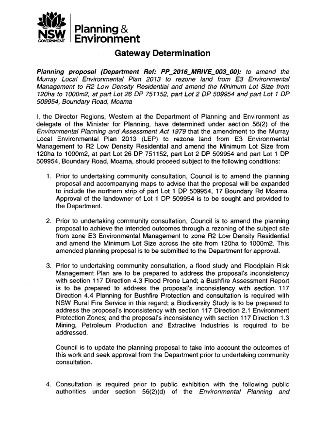
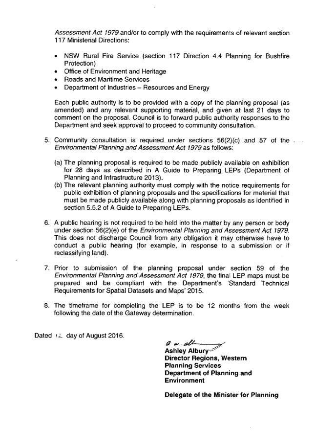
13.5 Changes
to the Wakool Development Control Plan 2013 - Clause A.4.5 River Structures and
Boating Facilities
File
Number: -
Author: Simon
Arkinstall, Director Planning & Environment
Authoriser: Simon
Arkinstall, Director Planning & Environment
|
Recommendation
That Council amend the Wakool Development Control Plan
2013 to permit Council owned public infrastructure within the mooring
exclusion zones within Barham, Tooleybuc and Moulamein where attached to land
owned or managed by Council.
|
Background
Council at its meeting of March 2018 resolved to amend
Clause A.4.5 of the Wakool Development Control Plan to permit public
infrastructure within the Mooring exclusion zones, with the following
resolution being adopted:
‘That Council resolve to amend the Wakool
Development Control Plan 2013 to permit Council owned public infrastructure
within the mooring exclusion zones within Barham, Tooleybuc and Moulamein where
attached to land owned or managed by Council.’
The proposed amendment was placed on public exhibition with
no submissions being received.
Discussion
The former Wakool Shire Council had developed and adopted a
policy that restricted / prohibited the installation of river related
structures within specified exclusion zones located in Barham, Tooleybuc and
Moulamein. In reviewing the policy, it is suggested that the aim of same was to
protect and preserve the river aesthetics and the aesthetics of each community.
In the development of the Wakool Development Control Plan
2013 (WDCO 2013), this policy was incorporated under Clause A.4.5, which reads
as follows:
A.4.5 RIVER STRUCTURES & BOATING FACILITIES
Note: Proponents should also review and address the
requirements of Part 6 of WLEP2012, particularly Clause 6.6 Riparian land &
the Murray River and other watercourses and Clause 6.7 Development on
river bed and banks of the Murray River. Proponents should determine if the
development application is classified as integrated development under Section
91 of the Environmental Planning & Assessment Act 1979 and if a controlled
activity approval is required.
1) Objective(s): To maintain the river corridor and
waterway in its natural environment by restricting the use of the river for
permanent moorings for houseboats and other commercially operated vessels in
certain areas of key watercourses.
2) Regional Plan: Moorings, mooring pens, marinas, wharf
or boating facilities, boat launching ramps, jetties, boat sheds, and water
recreation structures require approval under the provision of Murray River
Regional Environmental Plan No.2. Development may also require a River
Application and/or Bed and/or Bank Application as required in Appendix 1.
3) Prohibited Areas: Council will not approve any
applications for moorings, mooring pens, marinas, wharf or boating facilities,
boat launching ramps, jetties, boat sheds, water recreation structures and/or
ancillary works (including pump ashore facilities) in key watercourses
designated on the Mooring Exclusion Map in Appendix 6 Maps for Barham,
Tooleybuc, and Moulamein (where it is incompatible with the appearance of the
surrounding areas) UNLESS the uses listed are ancillary to an approved retail
or commercial use and meet all other controls in WLEP2012 and this DCP.
Again, the implementation of this clause within the WDCP
2013 was aimed at protecting the scenic quality of the river, and to reduce the
visual impact associated with permanent moorings
During the Stronger Community Fund - Major Projects it was
evident that both the Barham and Tooleybuc communities thought that the
installation of a mooring structure on the river would be advantageous. It was
suggested that such structures would permit vessels to moor on a temporary
basis and access the facilities and businesses within each town.
It is suggested that the mooring of any vessel would only be
on a temporary basis.
In investigating these proposals it was determined that the
current WDCP 2013 was restrictive and would not permit Council to approve a
mooring within these restricted zones.
If Council were to consider the potential installation of a
mooring within these restricted zones, it should first consider the aim of such
clause. As stipulated in the WDCP 2013 the aim of Clause A.4.5 is as follows:
1) Objective(s): To maintain the river corridor and
waterway in its natural environment by restricting the use of the river for
permanent moorings for houseboats and other commercially operated vessels in
certain areas of key watercourses.
It is in the opinion of staff there are two main components
of this objective, the first being to maintain the visual importance of the
riverine environment and secondly achieving same by restricting permanent
moorings.
Council could consider an area such as Victoria Park in
Echuca as an example as to why the former Wakool Shire Council had adopted this
clause within the WDCP 2013. At Victoria Park, there is a proliferation of
houseboats, similar that are permanently moored, and as a result there has been
a significant impact on the visual amenity of the riverine environment.
To maintain this objective, but also meet the expectation of
specific community groups that the WDCP 2013 could be amended to incorporate
the following;
- Only permit one public mooring structure within the
exclusion zones; and
- That the one
public mooring must be attached to or be adjacent to land owned or managed by
Council; and
- That the public mooring only permit temporary mooring of
vessels; and
- That the public mooring must be an asset of Council.
Staff therefore suggest that Clause A.4.5 of the WDCP 2013
be amended to read as follows:
A.4.5 RIVER STRUCTURES & BOATING FACILITIES
Note: Proponents should also review and address the
requirements of Part 6 of WLEP2012, particularly Clause 6.6 Riparian land &
the Murray River and other watercourses and Clause 6.7 Development on
river bed and banks of the Murray River. Proponents should determine if the
development application is classified as integrated development under Section
91 of the Environmental Planning & Assessment Act 1979 and if a controlled
activity approval is required.
1) Objective(s): To maintain the river corridor and
waterway in its natural environment by restricting the use of the river for
permanent moorings for houseboats and other commercially operated vessels in
certain areas of key watercourses.
2) Regional Plan: Moorings, mooring pens, marinas, wharf
or boating facilities, boat launching ramps, jetties, boat sheds, and water
recreation structures require approval under the provision of Murray River
Regional Environmental Plan No.2. Development may also require a River
Application and/or Bed and/or Bank Application as required in Appendix 1.
3) Prohibited Areas: Council will not approve any
applications for moorings, mooring pens, marinas, wharf or boating facilities,
boat launching ramps, jetties, boat sheds, water recreation structures and/or
ancillary works (including pump ashore facilities) in key watercourses
designated on the Mooring Exclusion Map in Appendix 6 - Maps for Barham,
Tooleybuc, and Moulamein (where it is incompatible with the appearance of the
surrounding areas) UNLESS;
- the uses listed are ancillary to an approved retail or
commercial use and meet all other controls in WLEP2012 and this DCP; OR
- the river structure is a public facility under the
control of Council and is attached to or adjacent to land that is owned and or
managed by Council; and
- is the only structure located within the Mooring
Exclusion Zone utilised to moor vessels; and
- only permits the temporary mooring of vessels.
The abovementioned proposal was considered and supported by
Council at its meeting of March 2018 and as a result same was placed on public
exhibition for comment. Council did not receive any submissions as part of the
exhibition process.
Strategic Implications
1 - Strategic Theme 1: Built/Physical Environment
1.3 - Improve and maintain community infrastructure
1.3.1 - Plan and advocate for key river access areas
including boat ramps, wharves and bridges (Barham, Moama, Murray Downs,
Tooleybuc)
Budgetary Implications
Nil implications
Policy Implications
The Wakool DCP is a planning policy of Council and this
proposal will amend same to ensure compliance
Legislative Implications
The proposed amendment was advertised in accordance with the
relevant legislative requirements
Risk Analysis
· What
can happen? The pontoon projects forming part of the Stronger Country
Communities Fund (Round 1) not being able to be constructed at Barham and
Tooleybuc
· How
can it happen? By not amending the WDCP
· What
are the consequences of the event happening? The projects not proceeding
and funding being required to be returned to the State Government
· What
is the likelihood of the event happening? Low
· Adequacy
of existing controls? High
· Treatment
options to mitigate the risk? Amend the WDCP as per staff recommendation
Conclusion
Council has been approached by certain sectors of both the
Barham and Tooleybuc communities requesting that Council investigate the
opportunity for the installation of a river structure that permits the
temporary mooring of vessels within the river front areas.
The correct WDCP 2013 controls limit the ability to permit
such to occur, however this Plan can be amended to permit public mooring
structures, whilst also maintaining the objective to preserve the riverine
aesthetics.
With no submissions being received as part of the public
exhibition process it is suggested that the proposed amendment to the WDCP be
implemented.
Attachments
Nil
13.6 Stronger
Communites Fund (Major Projects) - Moama Recreation Reserve Multi Purpose
Pavilion
File
Number: -
Author: Simon
Arkinstall, Director Planning & Environment
Authoriser: Simon
Arkinstall, Director Planning & Environment
|
Recommendation
That Council endorse the preliminary concept for the
proposed pavilion to be designed and erected at the Moama Recreation Reserve
under the Stronger Communities Fund (Major Projects) program.
|
Background
Council allocated funding through the Stronger Communities
Fund – Major Projects towards the design and construction of a pavilion
adjacent to the main oval at the Moama Recreation Reserve.
The preliminary designs were completed and utilised in the
tender process when engaging Brandrick Architects to finalise the design
documentation. The preliminary design was completed in consultation with the
Moama Recreation Reserve user groups and Committee, and staff obtained Council
support for same at its meeting of 18 September 2018.
Based on the preliminary design Council engaged Brandrick
Architects to commence the development of the design and tender documentation.
Staff have subsequently been requested to incorporate a grand stand into the
design and as a result of this request a preliminary design including same has
been developed and is being presented to Council for in principal support.
Discussion
Staff engaged Brandrick Architects to develop the final
design and associated tender documentation for the pavilion to be constructed
at the Moama Recreation Reserve. A major consideration when developing the
concept design related to the actual ‘build funds’ allocated to the
project by Council, being $3.2 million.
A number of concepts were developed through the discussions
with the two main user groups, which were refined to meet the cost parameter,
with the final concept being tabled at the Moama Recreation Reserve Committee
meeting on 11 September 2018. The positioning of the pavilion was also enabled
to be altered as a result of ownership of the Moama Sports Club potentially
altering. The pavilion was moved to a position that is central to the main
oval, thus providing improved connectivity.
This concept design and location was supported by Council at
its meeting of 18 September 2018, as per the below resolution:
‘That Council adopt, in principle, the concept
design and location of the main pavilion to be constructed at the Moama
Recreation Reserve as part of the projects adopted through the Stronger
Communities Fund – Major Projects.’
Council staff and Brandrick Architects recently met to
refine a number of design matters and Staff were also requested to incorporate
a potential grand stand into the overall design. A copy of the preliminary
design has been attached to this report for Council’s information.
Council is advised that the User Groups have not had an
opportunity to review the proposed grand stand design, however staff are
presenting this to Council for consideration to enable the project to keep
moving forward.
Council is advised that it will be seeking an extension of
the proposed projects from the NSW Office of Local Government, as it will not
be completed within the required timeframe. The delay in the project can
be contributed to the lengthy community consultation process undertaken to
ensure that the final design meets the public expectations. The final plans if
supported by Council will be presented to the Moama Recreation Reserve
Committee for information.
The following comments can be provided in relation to the
proposed grand stand concept:
- it
will be positioned in front of the change rooms, which will be of a concrete
block wall construction and therefore will not have a significant impact upon
the original concept design;
- it
will result in a minor realignment of the building, which is now more centrally
located;
- it
will have the capacity to seat up to 400 people;
- the
construction cost will be in the vicinity of $375,000.00: and
- can
be constructed as a future stage if required
Strategic Implications
1 - Strategic Theme 1: Built/Physical Environment
1.3 - Improve and maintain community infrastructure
1.3.3 - Provide public facilities suitable for residential
and visitor use (toilets, community halls)
Budgetary Implications
It is anticipated that the proposed grand stand design will
cost in the vicinity of $375,000.00 to construct, which is not part of the
original budget.
Future tender documents will be structured in a manner that
will enable the grand stand to be costed separately and constructed in the
further if required. The final construction tenders will be required to be
presented to Council for consideration and it is at this stage Council will be
able to make a determination whether to proceed with the construction of the
grand stand. Alternatively Council could resolve to build the grand stand in a
staged approach or allocate the required funding to complete the project.
Policy Implications
Nil
Legislative Implications
Nil
Risk Analysis
· What
can happen? Project delayed
· How
can it happen? Not support the design
· What
are the consequences of the event happening? Council required to return
funding
· What
is the likelihood of the event happening? Low
· Adequacy
of existing controls? High
· Treatment
options to mitigate the risk? Adopt the preliminary design incorporating
grandstand
Conclusion
Council has completed the concept design for the proposed
pavilion to be constructed at the Moama Recreation Reserve. This project forms
part of the major projects associated with the Stronger Community Funds.
Staff have been requested to incorporate a grand stand into
the design and as such preliminary plans have been provided for Council’s
consideration. Staff are therefore seeking Council to approve in principle the
concept design for the pavilion, including the grand stand to enable the design
and tender process to proceed to the next stage, being the development of the
final design and construction drawings.
Attachments
1. Moama
Rec Reserve - Pavilion Concept ⇩ 
|
Ordinary Council Meeting Agenda
|
26 February 2019
|
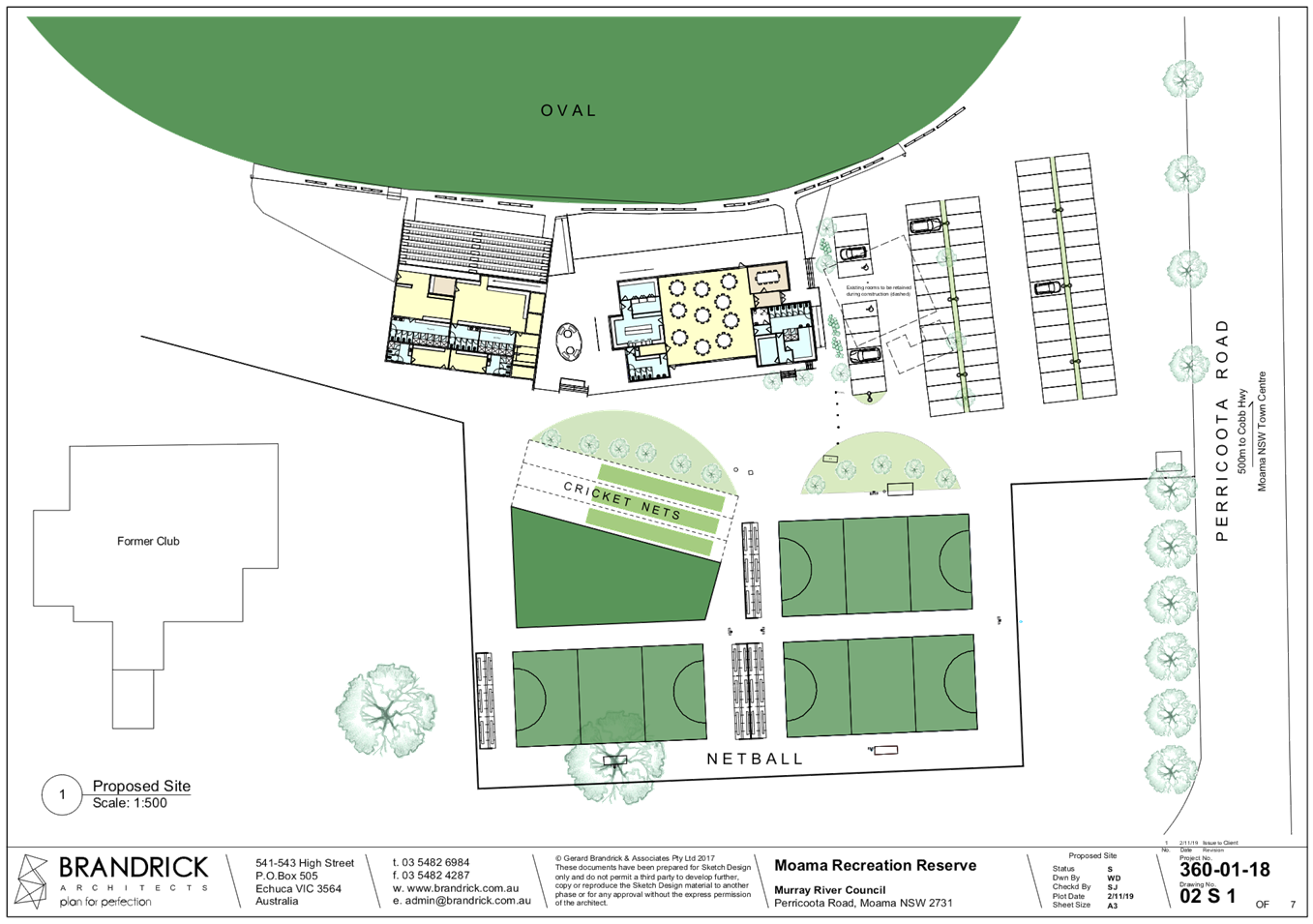
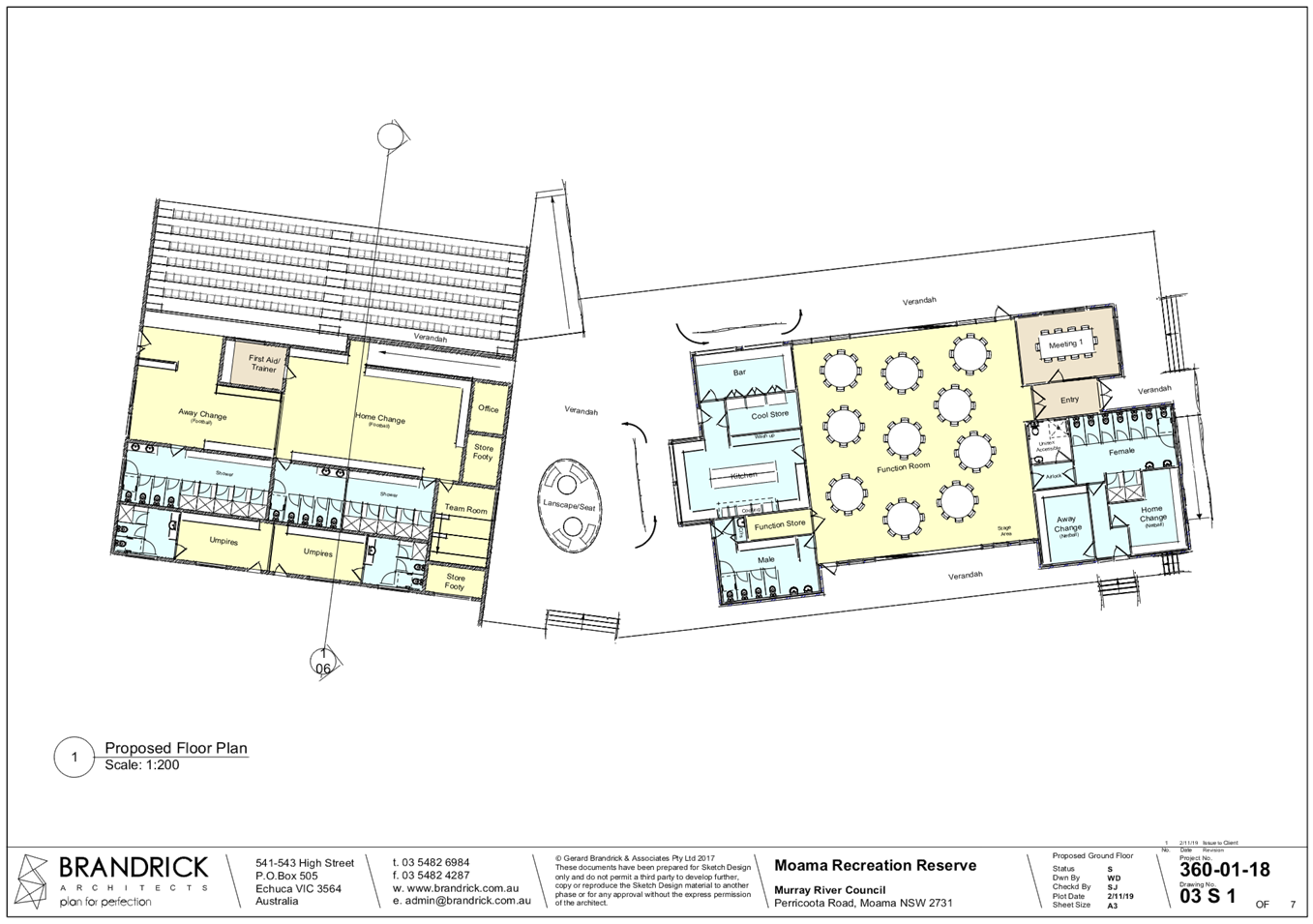
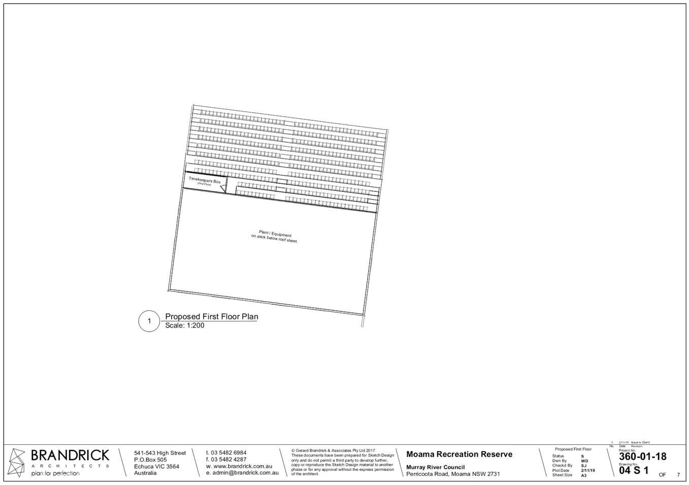
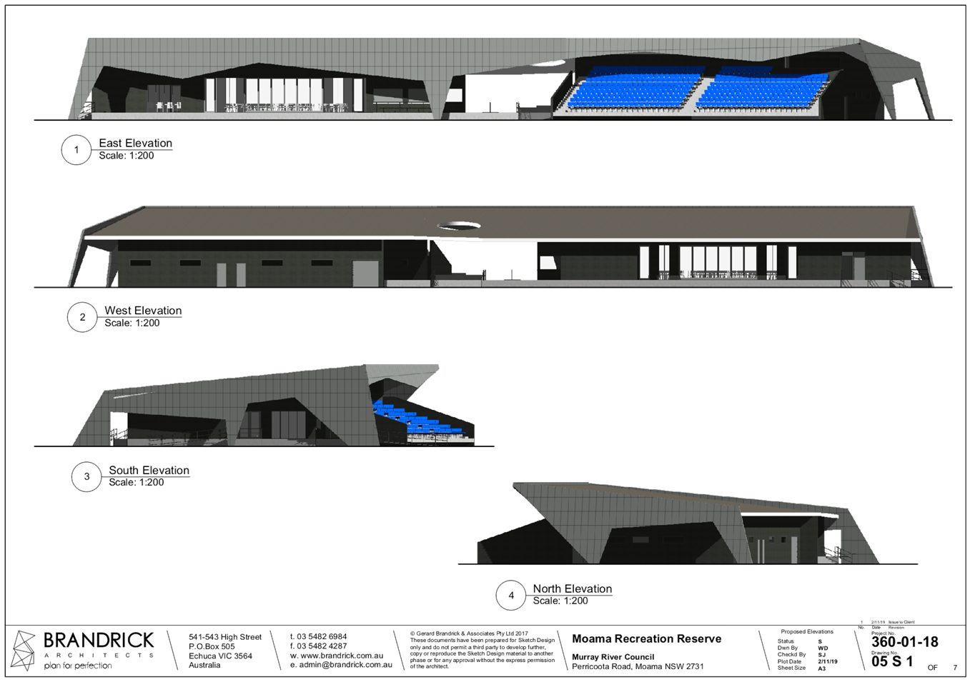
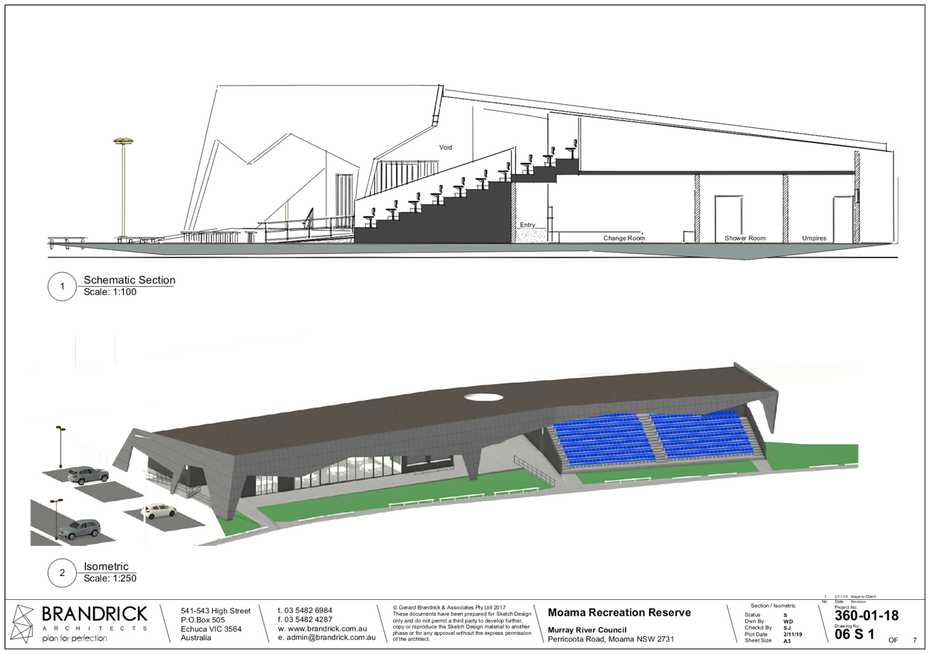
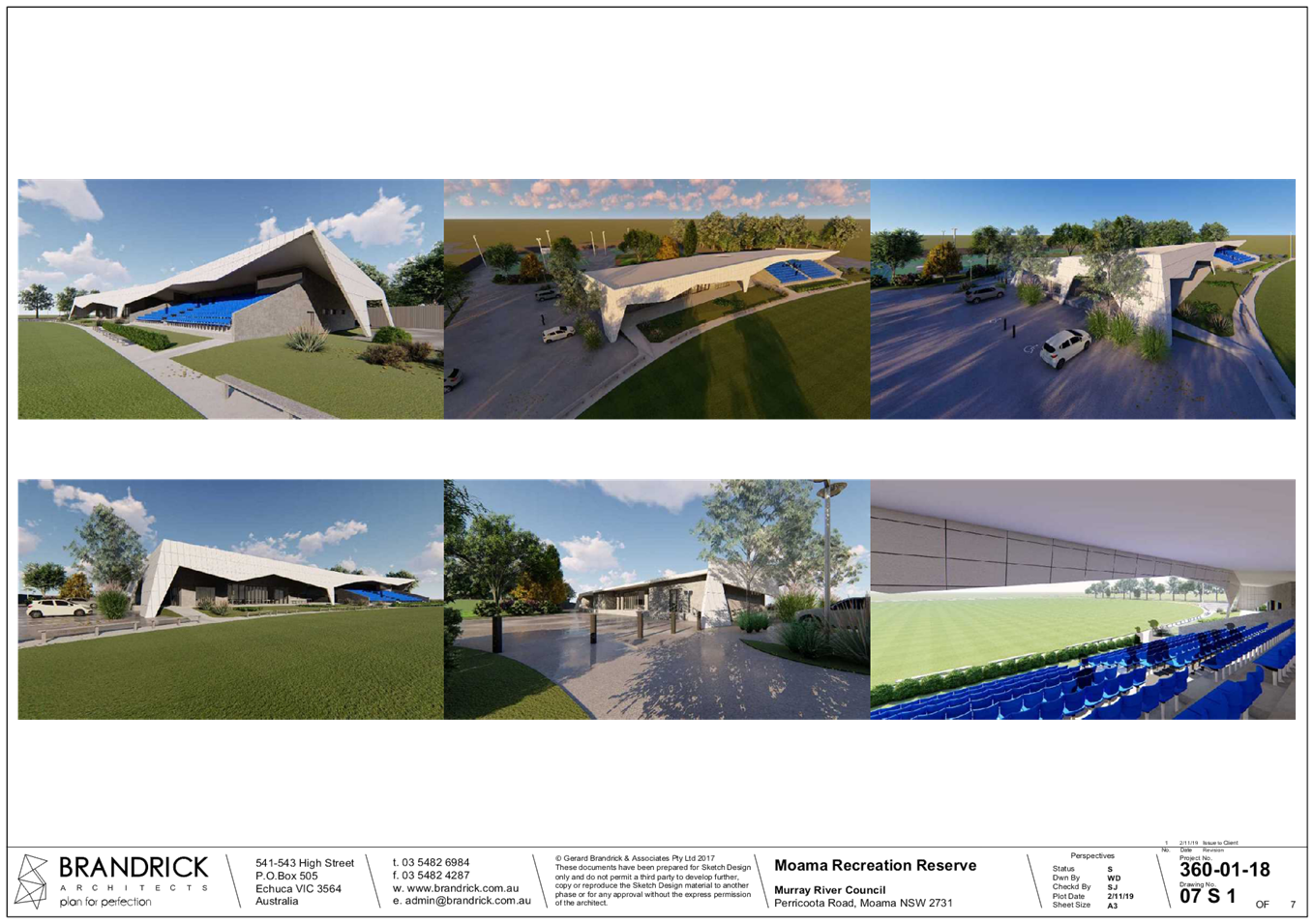
13.7 Notice
to Issue an Order - Development Approval 41/01
Lot 71 & 74 DP 756508 – East Barham Road, Barham NSW
File
Number: -
Author: Simon
Arkinstall, Director Planning & Environment
Authoriser: Simon
Arkinstall, Director Planning & Environment
|
Recommendation
1. That Council not
permit Gelletly Redgum Firewood store logs on Lot 109 DP1151560, 641 East
Barham Road, Barham as development approval is required for such a land use
and no development approval has been obtained.
2. That Council
require a development application to be submitted for consideration for the
storing of logs at Lot 109 DP1151560, 641 East Barham Road, Barham.
3. That Council
proceed with the issuing of the Order to ensure compliance with Development
Approval 041/01
|
Background
Council issued a development approval (DA 41/01) for the
storage of fire wood and spot mill on Lot 128 DP756508 East Barham Road,
Barham.
The fire wood storage and spot mill commenced operation,
however the site on where the development is currently situated is Lot 71 and
74 DP756508 and the current operation is being undertaken in breach of the
conditions associated with the development approval.
Council has received a complaint from a nearby property in
relation to the activity and as a result of the non-compliances Council has
issued a Notice of Intention to Issue and Order under the Environmental
Planning and Assessment Act, 1979 against the operator to cease operations.
The operator has proposed a solution to rectify the
situation and has requested the opportunity to address Council to outline and
seek approval for same.
Discussion
The following summary of information has been provided in an
attempt to provide an outline of the situation;
- Former
Wakool Shire Council receives a Development Application to undertake an
activity involving the storage of fire wood and a spot mill to be undertaken on
Lot 128 DP756508 East Barham Road, Barham.
- Former
Wakool Shire Council issues a Development Consent (041/01) for a fire wood
storage and spot mill operation on Lot 128 DP756508 East Barham Road, Barham.
- Development
of a fire wood storage and spot mill is commenced and continues today, however
this activity is being undertaken on Lots 71 and 74 DP756508 East Barham Road,
Barham.
- The
activity being undertaken is that as described on the application and approval,
however same is not being undertaken on the property described on both the
application and approval.
- On
reviewing the conditions of approval there could be an argument mounted that
the property on which the activity is being undertaken was the intended
location and the information supplied with the application was incorrect.
However, this does not rectify this anomaly from a legal perspective.
- Council
receives a complaint from a nearby property owner in relation to the
development raising a number of concerns, especially in relation to how the
development has expanded beyond the original approval.
- Staff
investigate the complaint and seek legal advice from Kell Moore and Associates
and subsequently issue a Notice of Intention to Issue an Order under the
Environmental Planning and Assessment Act, 1979.
- The
Notice of Intention requires the operator to cease operations as the
development is being undertaken on a property that is not the same as listed on
the application and approval.
- There
have been a number of meetings with the developer and complainant with an
intent to mediate a solution that will assist both parties.
The developer has provided potential options to resolve and
move this process forward in an attempt to address the complainants concerns
and has summarised this in the attached correspondence. The developer has
requested that Council permit the storage of logs on an alternate property in
the interim as this would allow them to reduce the footprint of the current
development to more align with the original development approval.
If this were to occur this would then permit the developer
to lodge a development application with Council to relocate the spot mill
business to the same property, subject to approval.
Council has also been advised by the complainant that as the
initial response from the developer in relation to the Notice of Intention did
not address their immediate concerns that their legal representative will be
requesting that the Order be issued (at the time of the report being written
Council has not received such correspondence).
Council is advised that the Wakool Local Environmental Plan
2013 requires development consent to be obtained for the storage of logs as
such would be associated with a sawmill and therefore be defined as a rural
industry. Hence, Council is unable to provide approval for this request as it
would be in direct contradiction to the Wakool Local Environmental Plan. The developer
will be required to submit a development application for consideration to
enable all relevant assessment matters to be addressed (i.e. noise, traffic
movements and similar).
Strategic Implications
5 - Strategic Theme 5: Leadership and Governance
5.1 - An effective, efficient and progressive Council that
provides leadership to the community
5.1.1 - Council decision making takes into account the needs
and priorities of our local communities and the longer term social, cultural,
economic and environmental viability and sustainability of our region
Budgetary Implications
Nil – note that if the complainant proceeds with a
Class 4 action in the Land and Environment Court and lists Council in such
proceedings Council may be required to contribute to the Plaintiffs legal
costs, fines or similar.
Policy Implications
Nil
Legislative Implications
Environmental Planning & Assessment Act 1979.
Risk Analysis
· What
can happen? Applicant permitted to store logs on alternate property without
required approvals
· How
can it happen? Council providing such permission
· What
are the consequences of the event happening? Legal challenges
· What
is the likelihood of the event happening? Medium
· Adequacy
of existing controls? High
· Treatment
options to mitigate the risk? Require development application to be
submitted and assessed
Conclusion
Council staff investigated a current fire wood and spot mill
business located on East Barham Road, Barham with such investigation revealing
that the development was being undertaken in breach of the current development
approval requirements.
Subsequently Council
issued a Notice of Intention under the Environmental Planning and Assessment
Act, 1979 until the non-compliances had been rectified.
The developer has requested that they be able to address
Council to seek permission to store logs on an alternate property in an attempt
to address a number of the concerns. Council is advised that as the storage of
logs are associated with a rural industry as defined by the Wakool Local Environmental
Plan 2013 permission for same can only be obtained through obtaining the
required development approval.
Attachments
1. Complainant
response ⇩ 
2. Development
Approval 41 01 ⇩ 
3. Letter
of request ⇩
4. Notice
of intention to Issue an Order ⇩
|
Ordinary Council Meeting Agenda
|
26 February 2019
|
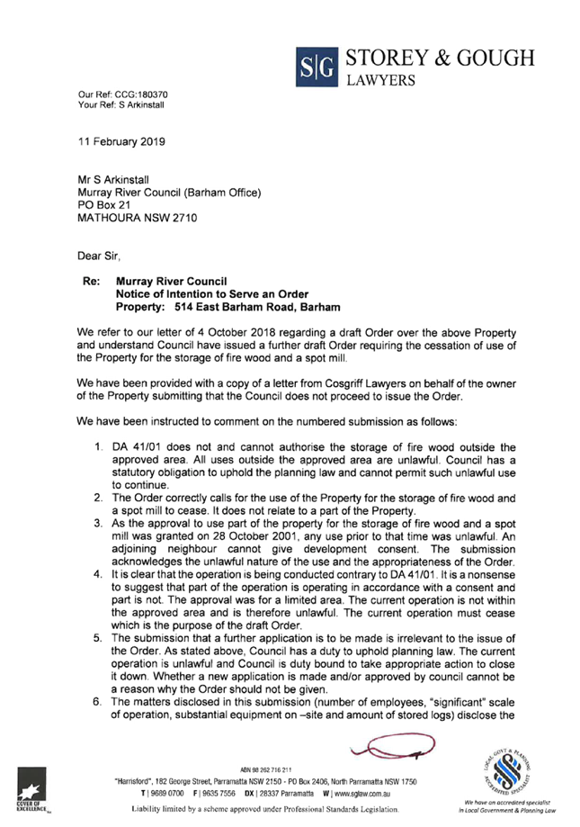
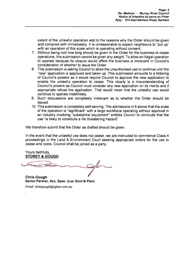
|
Ordinary
Council Meeting Agenda
|
26 February 2019
|
|
Ordinary
Council Meeting Agenda
|
26 February 2019
|

Todd Gelletly
Managing
Director Gelletly Red Gum Firewood
514 East Barham Road Barham NSW 2732
Ph: 0427185105
E: toddgelletly@bigpond.com
To the
Councillors of the Murray River Council,
I operate a
firewood business on the East Barham Road. For a number of reasons we now
are required to move our current operating premises.
Currently we
operate under DA’s 41/01 and 12/10.
We are in the
process dealing with a notice of intent from the Murray River Council in
relation to our current site.
Part of the
response to the NOI is to relocate our operating premises.
In order to
speed up the transition to a new site we seek approval to operate temporarily
on a new site. The approval to store logs at this site will greatly speed
up the transition from our existing site to this site. As we would be no
longer adding to our existing stockpiles
Our nearest
neighbours are supportive of this in lieu of the submission of a DA to operate
at this new site and the withdrawal of our existing DA’s at the current
site at a date to be determined.
The proposed
site is Lot 109, DP 1151560 and the access point is identified by rural address
number 641 East Barham Road.
There are no
Environmental, cultural or any existing overlays that would prevent the
proposed site from gaining approval in the future. I have conducted an
AHIMS Web Search of the Lot and DP number with no Aboriginal Sites or Places
identified in or near the location with a 50 meter buffer.
The situation
I find myself in is that an approval for a DA application would take some and
this will only exacerbate the concerns of one neighbour and prolonging the
timeframe in which I can transition to the proposed site.
The two
closest residences to the proposed site are owned by us currently, these would
fall into the category of “associated with the site”. The
nearest residences apart from these are 1.2km, 1.32km and 1.7km from the proposed
site.
Councillor’s
approval to the temporary use of the proposed site will assist appeasing the
concerns surrounding our current site.
I request to
attend the next meeting of Councillors to seek immediate approval commence
storing logs at the proposed site.
Yours Sincerely
Todd Gelletly
|
Ordinary
Council Meeting Agenda
|
26 February 2019
|
13.8 Planning
Proposal (PP_2018_MRIVE_001_00) to amend the Murray Local Environmental Plan
2011 - Insert 'public adminstration building' as additional permitted use on
Moama Recreation Reserve
File
Number: -
Author: Llyan
Smith, Town Planner
Authoriser: Simon
Arkinstall, Director Planning & Environment
Applicant: Murray
River Council
Owner: Department
of Industry- Crown Lands and Water
Proposal: Planning
Proposal (PP_2018_MRIVE_001_00) to amend the Murray Local Environmental Plan
2011 - Insert 'Public Administration Building' as additional permitted use on
Moama Recreation Reserve
Location: Part
Lot 261 DP 728943, 52 Perricoota Road, MOAMA NSW 2731
|
Recommendation
That Council proceed with the next stage of the Planning
Proposal
1. That Council
undertake the necessary tasks to obtain Parliamentary Counsel Opinion (PCO)
and request drafting of the new Murray Local Environmental Plan 2011 (Murray LEP 2011)
(a) Council undertake the
necessary tasks to finalise the amended Murray LEP 2011 in accordance with PP_2018_MRIVE_001_00
|
Background
At Murray River Council’s Ordinary
Meeting held on Tuesday 20 March 2018, Council resolved that the subject
‘Planning Proposal’ be submitted to the NSW Department of Planning
and Environment (DPE) with a request for Gateway Determination to amend the
Murray Local Environmental Plan 2011 (Murray LEP 2011). The subject Planning Proposal
seeks to insert 'Public Administration Building' into Schedule 1 of the Murray
LEP 2011 as an additional permitted use. The subject land is identified as part
Lot 261 DP 728943, 52 Perricoota Road, MOAMA NSW 2731. The subject land is
located within the Moama Recreation Reserve and is zoned RE2 Private Recreation.
All specifications regarding the land and the Planning Proposal have been
detailed to Council in previous reports heard at previous meetings of Council.
Council submitted the original Planning
Proposal to DPE on 30 July 2018 requesting a Gateway Determination be made. Council
received a Gateway response from DPE dated 17 August 2018 requiring certain
tasks to be undertaken prior to community consultation of the Planning
Proposal. Such tasks were:
· The addition of an LEP Additional Permitted Use Map to identify the
part of the Moama Recreation Reserve affected by the Planning Proposal;
· Removal of the ‘Draft’ watermark from the Planning
Proposal; and
· Deletion of “5.1 Implementation of Regional Strategies”
from the Planning Proposal and replacement with “5.10 Implementation of
Regional Plans”
No part of the Planning Proposal was
fundamentally altered. All tasks were completed to the satisfaction of DPE and
the Planning Proposal was approved to proceed to public consultation on 19
September 2018.
Discussion
Public consultation was undertaken for the
period beginning 5 December 2018 and ending 4:30pm 11 January 2019. No public
submissions were received. Consultation was undertaken with the
Department of Industry- Crown Lands and Water (as required by the Gateway
Determination). Department of Industry- Crown Lands and Water did not raise
objection or concern to the Planning Proposal. A public hearing was not
required in this instance.
Timeline
The below table provides an overview of the timeline with
respect to the lodgement and assessment of the planning proposal.
|
Council resolved to support Planning Proposal and send to
DPE for Gateway Determination.
|
20 March 2018
|
|
Planning Proposal sent to DPE requesting Gateway
Determination.
|
30 July 2018
|
|
Gateway determination received from DPE.
|
17 August 2018
|
|
Amended Planning Proposal submitted to DPE with request to
proceed to public consultation.
|
4 September 2018
|
|
Confirmation received from DPE to proceed to public
consultation (dated 11 September 2018).
|
19 September 2018
|
|
Consultation with Department of Industry- Crown Lands and
Water.
|
4 December 2018
|
|
Community consultation commenced.
|
5 December 2018
|
|
Response from Department of Industry- Crown Lands and
Water received (no issued identified).
|
10 January 2019
|
|
Community consultation closed.
|
11 January 2019
|
Submissions
No public submissions were received. Department of Industry-
Crown Lands and Water did not raise objection or concern with the Planning
Proposal. Department of Industry- Crown Lands and Water suggested that
“…As Council are currently the Crown Land
Managers of the adjoining Crown land known as the Moama Recreation Reserve it
may be worthy of consideration to add Lot 261 DP 728943 to R550000 to assist in
the future management of the Crown land by Murray River Council...”
Subject Site
The subject land has been detailed to Council in previous
reports. The land is identified as part Lot 261 DP 728943, 52
Perricoota Road, MOAMA NSW 2731. The “Moama Area 1” land shown by
the red outline in Figure 1 below is the land the subject of this Planning
Proposal.
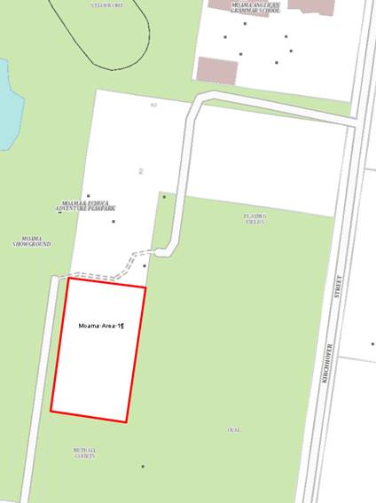
Figure 1 –
Subject land
Proposal
The proposal has been detailed to Council in previous
reports heard at previous meetings of Council. The Planning Proposal seeks to
insert 'Public Administration Building' into Schedule 1 of the Murray LEP 2011
as an additional permitted use.
Statutory Assessment Process
The statutory assessment process affecting this Planning
Proposal has been detailed to Council in previous reports heard at previous
meetings of Council. The Planning Proposal has been assessed in accordance with
all relevant legislation.
Town Planning Assessment
The town planning assessment affecting this Planning
Proposal has been detailed to Council in previous reports heard at previous
meetings of Council. The Planning Proposal has been assessed in accordance with
all relevant legislation.
Conclusion
The Planning Proposal has successfully moved though the
public consultation stage of the Gateway process. Endorsement by Council will
allow staff to seek Parliamentary Counsel Opinion and move the project forward
towards the eventual adoption of the new Murray LEP 2011.
Attachments
Nil
File
Number: -
Author: Llyan
Smith, Town Planner
Authoriser: Simon
Arkinstall, Director Planning & Environment
|
Recommendation
That Council support the creation of a Planning Proposal
seeking to reclassify Part Lot 57 DP 1045248, River Gums Drive, Moama from
Community Land to Operational land for the purposes of residential
subdivision and associated park land.
1. That Planning
Staff create a Planning Proposal to reclassify Part Lot 57 DP 1045248, River
Gums Drive, Moama from Community Land to Operational
2. That Planning
Staff and Engineering staff create a concept subdivision design to facilitate
a practical and serviceable use of the subject lot, and incorporate the
design into the Planning Proposal.
3. That the final
Planning Proposal be submitted to Council at a future meeting for
consideration.
|
Background
Part Lot 57 DP 1045248, River Gums Drive, Moama is a Council
owned natural bushland are utilised as a passive recreation space within the
Wimbi Estate. It has been suggested to Council’s Planning Department that
offering this land for residential lots with associated park land would be a
more beneficial and economic use of this space. As such, planning staff are in
the preliminary stages of investigating the strategic suitability of the
conversion of this land from community land to operational land. Planning
staff are seeking Council’s preliminary support for this concept prior to
creating a Planning Proposal and associated subdivision design.
Discussion
The subject site is identified by the purple star in Figure
1, below. This lot is split into two parts. As shown in Figure 2, one part of
the lot is located to the west (indicated by the red outline and black star)
and is utilised as a buffer area. Part Lot 57 (shown by black star) was
reclassified to operational land as part of the original adoption of the Murray
LEP 2011 and is accordingly referenced in Schedule 4, Part 2 of the LEP.
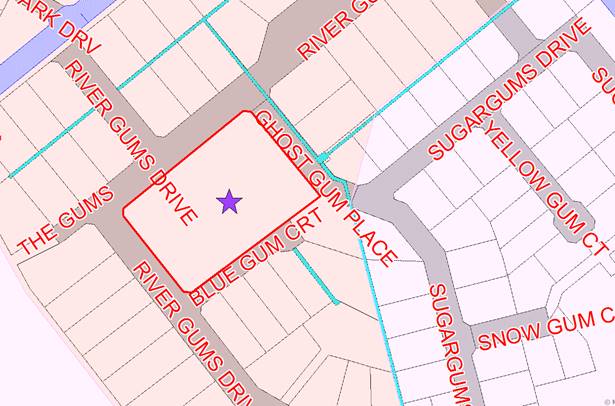
Figure 1- Subject site
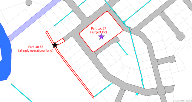
Figure 2 – Lot 5 (2 parts)
The subject site has an area of 1.369 hectares (13,690m2)
and is zoned R2 Low Density Residential with a minimal lot size requirement of
1500m2. The subject site is not covered by any biodiversity or
hazard overlays and is not utilised by the Wimbi Estate as a stormwater
retention area. The site has access to all required services and is burdened on
the eastern corner by a Council sewer line. See Figure 3 below for further
information with respect to the location of services. The Murray Strategic Land
Use Plan identifies this land for residential use and redevelopment of the land
as residential lots would fit the character of the surrounding residential land
uses. Should the proposal receive preliminary support from Council, any
resulting Planning Proposal and associated subdivision design would take into
consideration the surrounding character of development. The resulting Planning
Proposal would seek to amend “Schedule 4 – Part 1 Land classified,
or reclassified, as operational land- no interest changed” of the Murray
LEP 2011. No other aspect of the Murray LEP 2011 (such as zoning or minimum lot
size) would require amendment. Any Planning Proposal prepared would
consider and discuss any net community benefit/loss resulting from the removal
of natural park land within this estate.
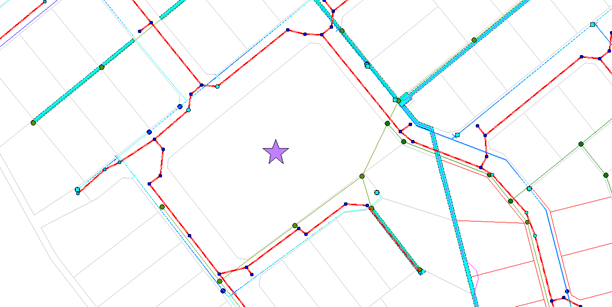
Figure 2 - Services
Strategic Implications
1 - Strategic Theme 1: Built/Physical Environment
1.1 - Improve and maintain our built town environments
1.1.1 - Support each township to develop their unique
character
Budgetary Implications
If the land was rezoned to permit a subdivision to occur
Council will be required to allocate funding to enable the subdivision to
occur.
Should the Planning Proposal be supported, the resulting
residential lots would be offered for sale by Council and would return a
positive revenue stream at the time the lots are sold.
Policy Implications
Nil.
Legislative Implications
In accordance with Part 2 of the Local Government Act
1993
Should the Planning Proposal ultimately be supported,
“Schedule 4 – Part 1 Land classified, or reclassified, as
operational land- no interest changed” of the Murray LEP 2011 would
require amendment. Clause 5.2 of the Murray LEP 2011 (enabled by Part 2 of
Chapter 6 of the Local Government Act 1993) legally facilitates Council
to reclassify public land. The following summary
Risk Analysis
· What
can happen? Land remain the same use
· How
can it happen? Council deem the reclassification as unnecessary
· What
are the consequences of the event happening? Public satisfaction / dissatisfaction
· What
is the likelihood of the event happening? Low
· Adequacy
of existing controls? High
· Treatment
options to mitigate the risk? Council resolve to either take action of no
action
Conclusion
Council staff have been requested to consider the
reclassification of park land located within the Wimbi residential estate from
community land to operational land. This would permit Council if deemed
warranted to subdivide portions of the land for residential purposes.
The land is maintained as natural bushland and currently
offers little benefit to active residential pursuits. Prior to any
reclassification occurring further reports will need to be presented to Council
for consideration.
If the project were to proceed the funds generated as a sale
of any lots should be utilised for the future development of community land
within Council.
Attachments
Nil
15 Correspondence
Report
15.1 Correspondence
Report
File
Number: -
Author: Kerri
Keogh, Manager Office of the General Manager
Authoriser: Des
Bilske, General Manager
Discussion
01/02: Local Government NSW Weekly
Indices of General Circulars dated 18 January, 25 January,
1 February, 8 February and 15 February 2019 have been forwarded to
Councillors and Senior Staff via email.
02/02: Australian Local Government Association (ALGA) News
Newsletters dated 1 February, 8 February and 15
February 2019 have been forwarded to Councillors and
Senior Staff via email.
03/02: Echuca Moama Beacon Foundation Inc.
Forwarding a Certificate of Appreciation in recognition of
Council’s valuable support as a sponsor of the Beacon Foundation in 2018.
Refer Attachment 1.
04/02: Heritage Council of New South Wales
Forwarding correspondence dated 9 January 2019 responding
to Council’s representation regarding the future of the Bridge over the
Murray River at Swan Hill. Refer Attachment 2.
05/02: Member for Murray, Austin Evans MP
Forwarding a Media Release dated 17 January 2019 announcing
that the Murray electorate will receive $1.3M in vital road safety upgrades as
part of the latest round of the Government’s Saving Lives on Country
Roads and Liveable and Safe Urban Communities initiatives. Refer Attachment 3.
06/02: Member for Murray, Austin Evans MP
Forwarding a Media Release dated 24 January 2019
congratulating the Swan Hill Murray Downs Field and Game for being successful
in securing funding of $18,000 in the Safe Shooting Program. Refer Attachment 4.
07/02: Member for Murray, Austin Evans MP
Forwarding a Media Release dated 6 February 2019 announcing
that the Riverina and Murray Joint Organisation (RAMJO) has been awarded a
$419,460 grant through the NSW Government’s $4M Council Regional Capacity
Building Program. Refer Attachment 5.
08/02: Mathoura Public School
Forwarding correspondence dated 19 December 2018 thanking
Council for the generous donation of $100 for book awards and two medallions
for Student Citizenship Awards at the School’s 2018 Annual Presentation
Function. Refer Attachment 6.
09/02: Local Government NSW
Forwarding a
Media Release dated 12 February 2019 congratulating Innovation and Better
Regulation Minister, Matt Kean, on his plan to establish an independent
Building Commissioner to oversee a clear line of responsibility for the safety
and quality of construction. Refer Attachment 7.
10/02: Local Government NSW
Forwarding a
Media Release dated 12 February 2019 congratulating NSW Labor leader Michael
Daley on election commitments which would help address two major issues –
overdevelopment in Sydney and underinvestment in roads in regional NSW. Refer
Attachment 8.
11/02: Deniliquin High School
Forwarding correspondence
dated 11 February 2019 thanking Council for the
generous donation of $100 towards the School’s 2018 Annual Presentation
Night. Refer Attachment 9.
12/02: Friends of Old Moama
Forwarding Minutes
of their General Meeting and Annual General Meeting of 5 February 2019. Refer
Attachment 10.
13/02: Riverina and Murray Joint
Organisation (RAMJO)
Forwarding the
Agenda of its Meeting held on 5 February 2019 at 10:00am in the Ian Gilbert
Room, Jerilderie Administration Centre, Murrumbidgee Council, Jerilderie. Refer
Attachment 11.
Attachments
1. Echuca
Moama Beacon Foundation - Certificate of Appreciation 2018 ⇩ 
2. OEH
Future of Bridge Murray River at Swan Hill ⇩ 
3. Member
for Murray - Saving roads on country lives funding ⇩
4. Member
for Murray-Safe Shooting grants Swan Hill Murray Downs Field and Game ⇩
5. Member
for Murray - Riverina and Murray JOC funding ⇩
6. Mathoura
Public School - Thank you ⇩
7. LGNSW
- LGNSW welcomes much-needed building reform ⇩ 
8. LGNSW
- Plans to halt developer-led rezoning and fund local roads welcome ⇩
9. Deniliquin
High School - Thank you ⇩
10. Friends
of Old Moama - General Meeting & Annual General Meeting Minutes 05/02/19 ⇩
11. RAMJO
Agenda - Board Meeting 13/02/19 ⇩
|
Ordinary Council Meeting Agenda
|
26 February 2019
|
|
Ordinary Council Meeting Agenda
|
26 February 2019
|

|
Ordinary
Council Meeting Agenda
|
26 February 2019
|

|
Ordinary Council Meeting Agenda
|
26 February 2019
|
|
Ordinary Council Meeting Agenda
|
26 February 2019
|
|
Ordinary Council Meeting Agenda
|
26 February 2019
|
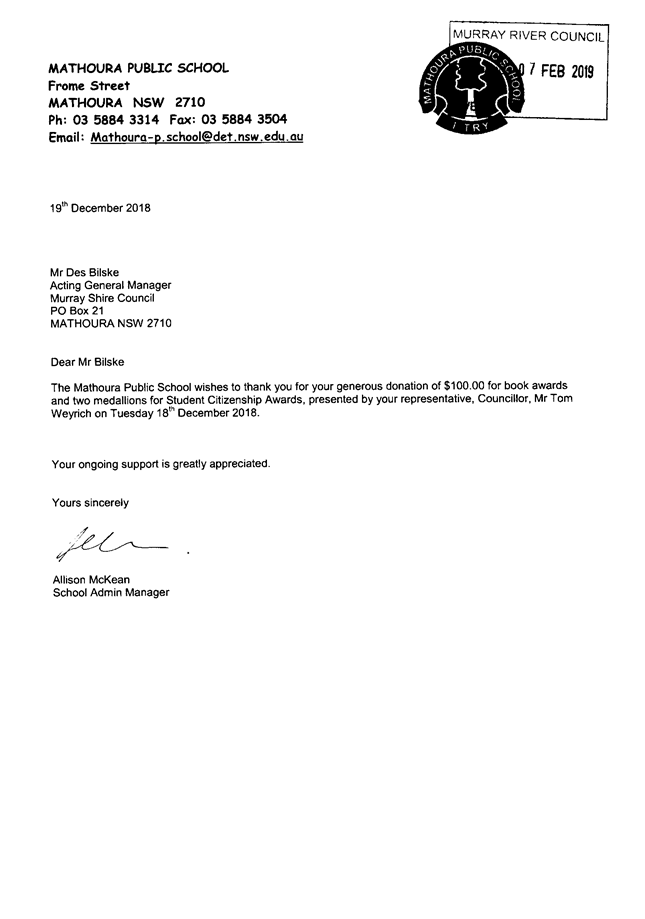
|
Ordinary Council Meeting Agenda
|
26 February 2019
|

|
Ordinary
Council Meeting Agenda
|
26 February 2019
|
|
Ordinary
Council Meeting Agenda
|
26 February 2019
|
|
Ordinary Council Meeting Agenda
|
26 February 2019
|

|
Ordinary
Council Meeting Agenda
|
26 February 2019
|
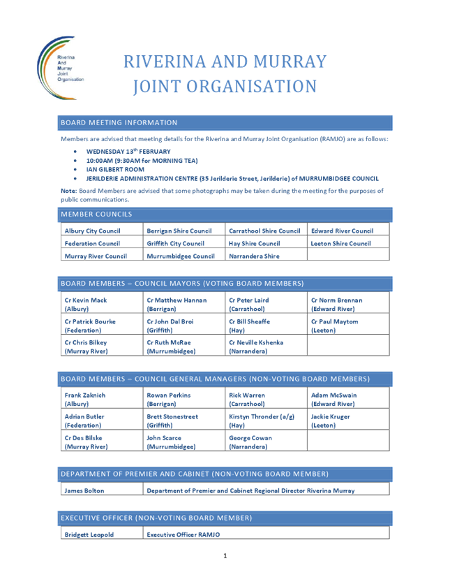

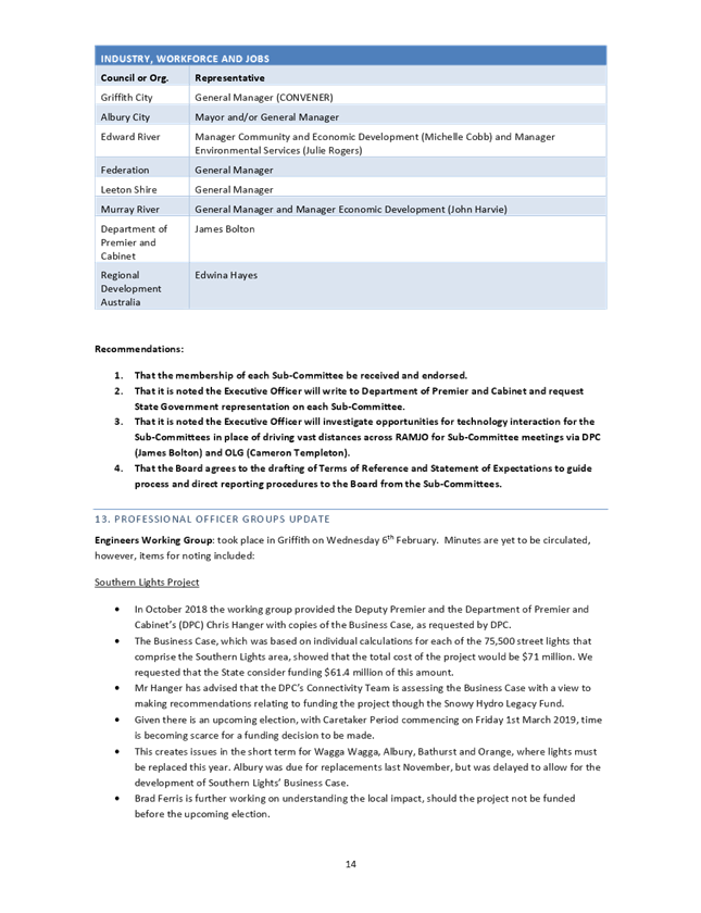
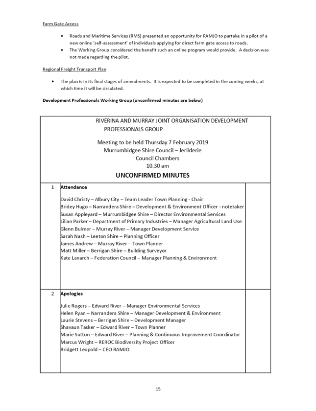
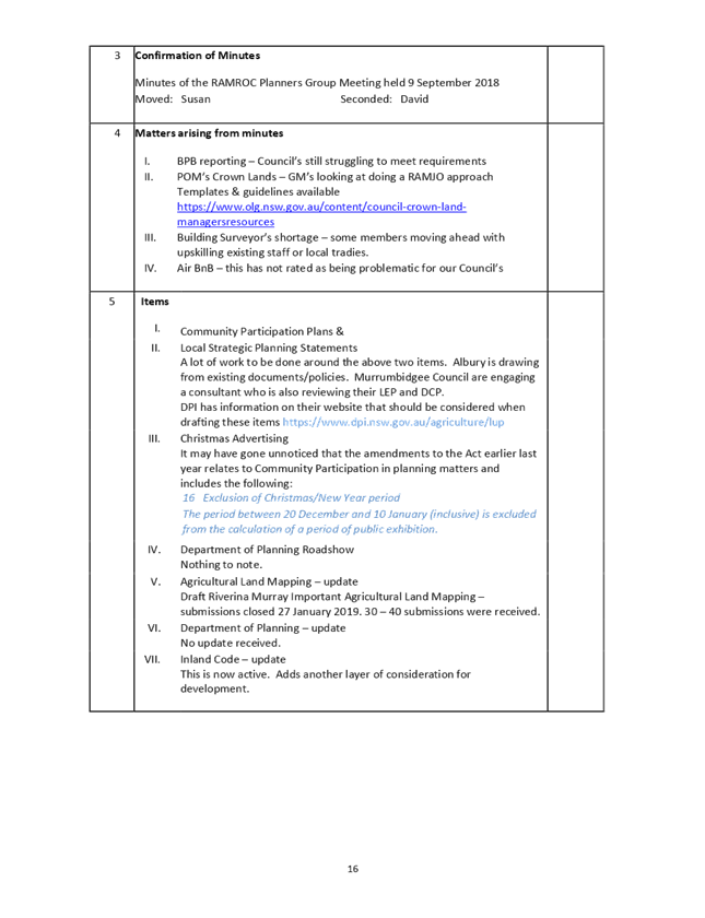
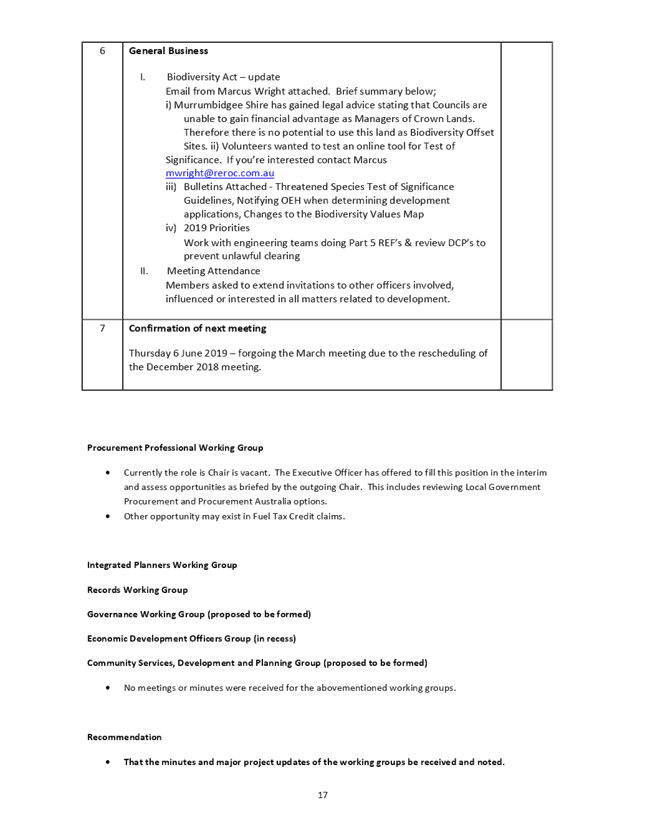
16 Sundry
Delegates Report
16.1 Sundry
Delegates Report
File
Number: -
Author: Kerri
Keogh, Manager Office of the General Manager
Authoriser: Des
Bilske, General Manager
|
Recommendation
That the Sundry Delegates Reports
of the Mayor and Councillors be received by the Council and reasonable out of
pocket expenses be met by Council.
|
Discussion
The Mayor, Councillor CR Bilkey reported on his
attendance at the following meetings and functions:
· 22 Jan: Pre-Council
Meeting Presentation & Briefings – Moama
· 22 Jan: Ordinary
Meeting of Council – Moama
· 23 Jan: Community
Living & Respite Services Promotional Video Filming – Murray River
Tea Rooms, Moama
· 24 Jan:
Phone Interview with 3SH
· 25 Jan:
Australia Day Eve Dinner with Ambassador
– Murray Downs
· 26 Jan:
Australia Day Community Breakfast &
Official Ceremony, including Citizenship Ceremony – Koraleigh
· 01 Feb: St
Joseph’s College Echuca Opening College Mass & Leaders’
Induction Ceremony – Echuca
· 11 Feb: Radio EMFM
Segment – Echuca
· 13 Feb: Riverina and
Murray Joint Organisation Board Meeting – Jerilderie
· 14 Feb: Councillor
Refresher Training for LG Hub – Moama
· 19 Feb:
Councillor Workshop – Council’s Position on Water Issues; Echuca
Moama Flood Study Briefing; Mid-West Moama Drainage Investigation; Warden
Street Moama Development – Moama
· 19 Feb:
Councillor Inspection – Boundary Road (Moama) – Moama
· 20 Feb: Climate Change
Meeting – Edward River Council, Deniliquin
· 21 Feb:
Presentation of Bridge Arts & Meninya Street Masterplan Draft Concept
– Moama
· 21 Feb: 100th
Birthday Presentation x 2 – Southern Cross Apartments, Moama
The Deputy Mayor, Councillor GS Campbell reported on
her attendance at the following meetings and functions:
· 22 Jan:
Pre-Council Meeting Presentation & Briefings – Moama
· 22 Jan:
Ordinary Meeting of Council – Moama
· 14 Feb: Councillor
Refresher Training for LG Hub – Moama
Councillor A Aquino
reported on his attendance at the following meetings and functions:
· 22 Jan:
Pre-Council Meeting Presentation & Briefings – Moama
· 22 Jan:
Ordinary Meeting of Council – Moama
· 26 Jan:
Australia day award presentation – Echuca
· 14 Feb:
Councillor Refresher Training for LG Hub –
Moama
· 19 Feb:
Councillor Workshop – Council’s Position on Water Issues; Echuca
Moama Flood Study Briefing; Mid-West Moama Drainage Investigation; Warden
Street Moama Development – Moama
· 19 Feb:
Councillor Inspection – Boundary Road (Moama) – Moama
Councillor NF Cohen
reported on her attendance at the following meetings and functions:
· 22 Jan:
Pre-Council Meeting Presentation & Briefings – Moama
· 22 Jan:
Ordinary Meeting of Council – Moama
· 26 Jan:
Australia Day Celebrations – Mathoura
· 29 Jan:
Meeting with General Manager & Manager Parks & Open Spaces RE: VACSAL
Indigenous Carnival held at Moama Recreation Reserve – Moama
· 29 Jan:
Meeting with General Manager & Councillors RE: Pavilion Renovations at
Mathoura Recreation Reserve – Moama
· 5 Feb:
Friends of Old Moama Committee Meeting – Moama
· 7 Feb:
Southern 80 Ski Race Launch – Echuca
· 12 Feb:
Moama Recreation Reserve Management Committee Meeting – Moama
· 14 Feb:
Councillor Refresher Training for LGHub – Moama
· 19 Feb:
Councillor Workshop – Council’s Position on Water Issues; Echuca
Moama Flood Study Briefing; Mid-West Moama Drainage Investigation; Warden
Street Moama Development – Moama
· 19 Feb:
Councillor Inspection – Boundary Road (Moama) – Moama
· 21 Feb:
Presentation of Bridge Arts & Meninya Street Masterplan Draft Concept
– Moama
· 25 Feb:
Echuca Moama Sportstar Awards – Moama Bowling Club
Councillor A Crowe
reported on her attendance at the following meetings and functions:
· 22 Jan:
Pre-Council Meeting Presentation & Briefings – Moama
· 22 Jan:
Ordinary Meeting of Council – Moama
· 19 Feb:
Councillor Workshop – Echuca Moama Flood Study Briefing; Mid-West Moama
Drainage Investigation; Warden Street Moama Development – Moama
· 19 Feb:
Councillor Inspection – Boundary Road (Moama) – Moama
Councillor NH Gorey reported on his attendance at the following meetings and
functions:
· 22 Jan:
Pre-Council Meeting Presentation & Briefings – Moama
· 22 Jan:
Ordinary Meeting of Council – Moama
· 25 Jan:
Meeting with Tooleybuc Action Group RE: pontoon wharf – Tooleybuc
· 25 Jan:
Australia Day Eve Dinner with Ambassador
– Murray Downs
· 26 Jan:
Australia Day Breakfast – Moulamein
· 11 Feb:
Barham Recreation Reserve Management Committee
Meeting – Barham
Councillor AM Mathers
reported on his attendance at the following meetings and functions:
· 22 Jan:
Pre-Council Meeting Presentation & Briefings – Moama
· 22 Jan:
Ordinary Meeting of Council – Moama
· 26 Jan:
Australia Day Presentations – Barham
· 26 Jan:
Australia Day Presentations – Wakool
· 1 Feb:
Moulamein Australia Day Eve Community BBQ & Fireworks (delayed due to
earlier total fire ban) – Moulamein
· 4 Feb:
Community Hub/Progress Association Meeting RE: request more water for Moulamein
Lake – Moulamein
· 8 Feb: Murray
Regional Strategy Group Meeting RE: irrigation water – Deniliquin
· 14 Feb:
Councillor Refresher Training for LGHub – Moama
· 15 Feb:
Murray Darling Basin Authority Development Program Funding – Barham Hub
· 18 Feb:
Murray Regional Strategy Group Meeting RE: water issues – Deniliquin
· 19 Feb:
Councillor Workshop – Council’s Position on Water Issues; Echuca
Moama Flood Study Briefing; Mid-West Moama Drainage Investigation; Warden
Street Moama Development – Moama
· 19 Feb:
Councillor Inspection – Boundary Road (Moama) – Moama
Councillor TE Weyrich
reported on his attendance at the following meetings and functions:
· 22 Jan:
Pre-Council Meeting Presentation & Briefings – Moama
· 22 Jan:
Ordinary Meeting of Council – Moama
· 26 Jan: Australia
Day Celebrations – Mathoura
· Central
Murray County Council Meeting – Deniliquin
Councillor GW Wise
reported on his attendance at the following meetings and functions:
· 15 Jan:
Meeting with Manager Economic Development & Tourism, John Harvie RE funding
for Day Care in Barham
· 15 Jan:
Meeting with Barham Preschool Committee & Consultant RE Day Care –
Barham
· 22 Jan:
Pre-Council Meeting Presentation & Briefings – Moama
· 22 Jan:
Ordinary Meeting of Council – Mathoura
· 26 Jan: Australia
Day Celebrations – Mathoura
· 04 Feb:
Meeting with Consultant RE Day Care in Barham – Barham
· 11 Feb:
Mathoura Retirement Village Management Committee Meeting – Mathoura
· 13 Feb:
Mathoura Recreation Reserve Management Committee Meeting – Mathoura
· 14 Feb:
Councillor Refresher Training for LG Hub – Moama
· 18 Feb:
Murray Shire (Mathoura) Hall Management Committee Meeting – Mathoura
· 19 Feb:
Councillor Workshop – Council’s Position on Water Issues; Echuca
Moama Flood Study Briefing; Mid-West Moama Drainage Investigation; Warden
Street Moama Development – Moama
· 19 Feb:
Councillor Inspection – Boundary Road (Moama) – Moama
· 21 Feb:
Presentation of Bridge Arts & Meninya Street Masterplan Draft Concept
– Moama
· 21 Feb:
Barham Preschool Committee visit to Pink & Blue – Echuca
· 25 Feb:
Barham Childcare Information Night, 7pm – Barham
Attachments
Nil
17 Confidential
Reports
|
Recommendation
That Council considers the confidential report(s) listed
below in a meeting closed to the public in accordance with Section 10A(2) of
the Local Government Act 1993:
17.1 Moama Waste
Management Facility – Account Customer
This matter is considered to be confidential under Section
10A(2) - c of the Local Government Act, and the Council is satisfied that
discussion of this matter in an open meeting would, on balance, be contrary
to the public interest as it deals with information that would, if disclosed,
confer a commercial advantage on a person with whom the Council is conducting
(or proposes to conduct) business.
17.2 Stronger Country
Communities Fund (Round 1) - Tooleybuc Recreation Reserve Amenities Building
This matter is considered to be confidential under Section
10A(2) - c of the Local Government Act, and the Council is satisfied that
discussion of this matter in an open meeting would, on balance, be contrary
to the public interest as it deals with information that would, if disclosed,
confer a commercial advantage on a person with whom the Council is conducting
(or proposes to conduct) business.
17.3 Reallocation of
budgeted capital expenditure for critical building asset works
This matter is considered to be confidential under Section
10A(2) - f of the Local Government Act, and the Council is satisfied that
discussion of this matter in an open meeting would, on balance, be contrary
to the public interest as it deals with details of systems and/or
arrangements that have been implemented to protect council, councillors,
staff and Council property.
|