|
|
|
AGENDA
Ordinary Council Meeting
Tuesday, 26 May 2020
|
|
I hereby give notice that an Ordinary Meeting of
Murray River Council will be held on:
|
|
Date:
|
Tuesday, 26 May 2020
|
|
Time:
|
6:00PM
|
|
Location:
|
Council Chambers
Moama Administration
Office
52 Perricoota Road, Moama
|
|
Des Bilske
General
Manager
|
4 Confirmation
of Minutes
4.1 Confirmation
of Minutes - Ordinary Meeting of Murray River Council held on 28 April 2020
File
Number: -
Author: Kerri
Keogh, Manager Office of the General Manager
Authoriser: Des
Bilske, General Manager
|
Recommendation
That the minutes of the
Ordinary Meeting of Murray River Council held on 28 April 2020 be confirmed
as a true and correct record.
|
Discussion
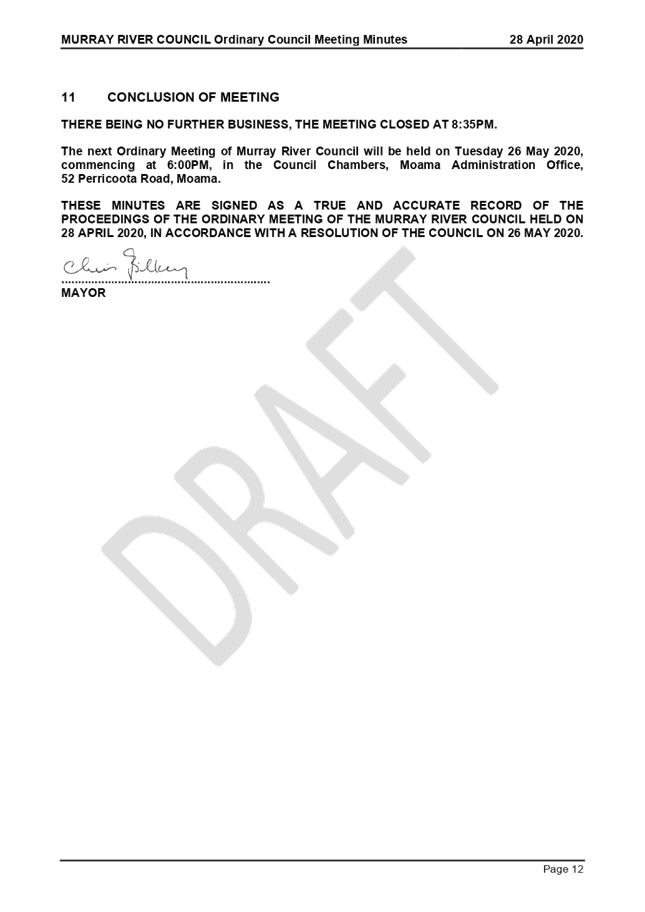
Murray River Council held its Ordinary Meeting of the Council
on Tuesday 28 April 2020, commencing at 6:00pm in the Council Chambers (Lower
Level), Moama Administration Office, 52 Perricoota Road, Moama.
A copy of the draft minutes are attached for ratification by
the Council at this meeting.
Attachments
1. MINUTES
Ordinary Meeting 280420_DRAFT ⇩ 
|
MURRAY RIVER
COUNCIL Ordinary Council Meeting Agenda
|
26 May 2020
|
8 Reports
to Council
8.1 General
Manager’s Report & Supplementary Matters
8.1.1 Resolutions
of the Council - Resolution Tracker & InfoCouncil Action Reports
File
Number: -
Author: Kerri
Keogh, Manager Office of the General Manager
Authoriser: Des
Bilske, General Manager
|
Recommendation
That the Council
receives and notes the status of previous resolutions of the Council (in open
and closed Council) contained in both the manual Resolution Tracker and
InfoCouncil Action Reports.
|
Background
As Councillors are aware, in September 2018 a manual Resolution Tracker (pertaining to
the resolutions of the previous Council meetings) was introduced as part of the
General Manager’s report to each Council meeting to allow Councillors to
review the current status (actions by Council’s officers) of their
decisions (resolutions).
In November 2018, Council introduced a report and minute
software called InfoCouncil. Resolutions of the Council that require action
after each Council Meeting are automatically generated in InfoCouncil to the
relevant Council officer for their action and comment.
Subsequently, the manual Resolution Tracker is now
superseded by the InfoCouncil Action Report. Once all resolutions in the manual
Resolution Tracker have been completed by Council’s officers, the
document will be archived.
Discussion
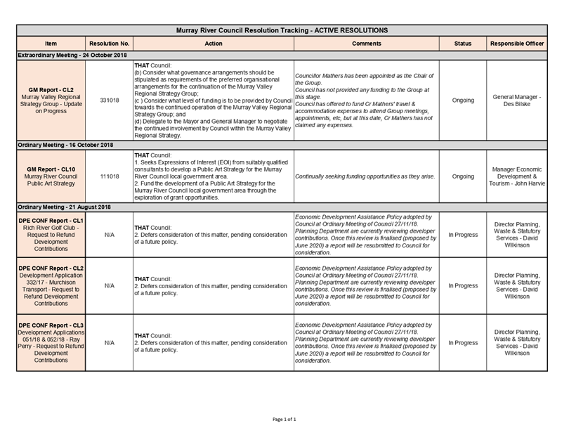
The manual Resolution Tracker (Attachment 1)
comprises ‘active’ resolutions from meetings of the Council held in
August to October 2018 (prior to the implementation of InfoCouncil) that
require action by Council’s officers. Resolutions that are reported by
Council’s officers as complete will drop off the ‘active’
list.
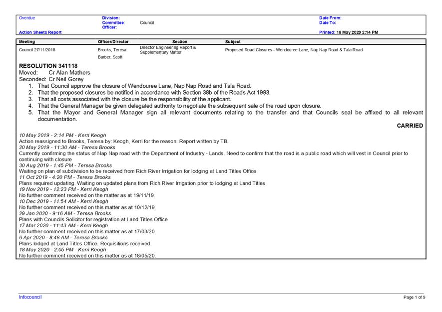
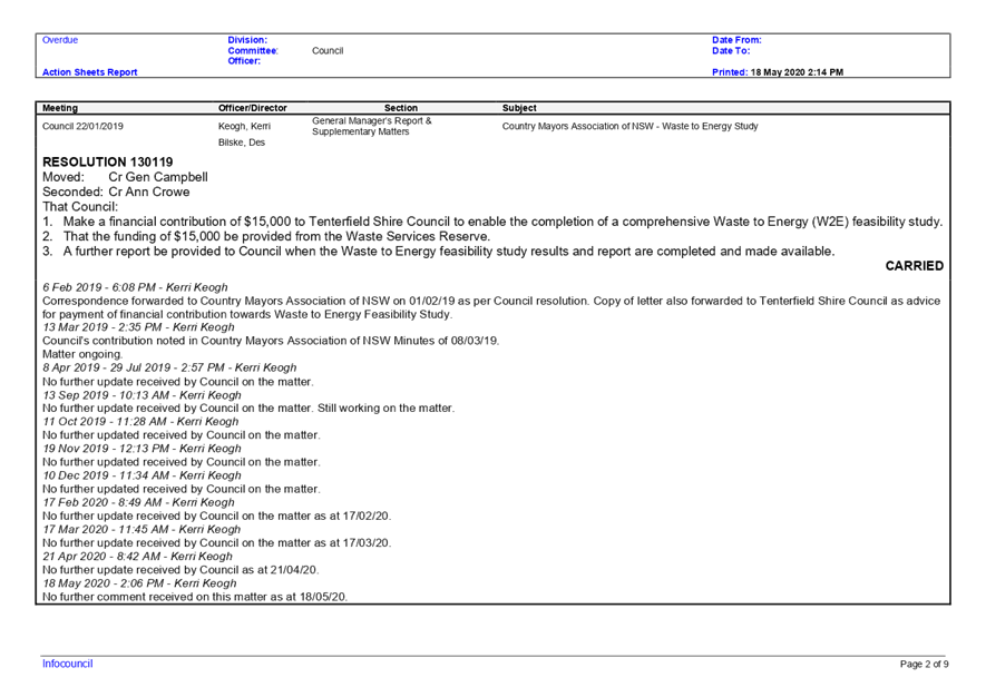
The InfoCouncil Action Report (Attachment 2)
comprises ‘active’ resolutions from meetings of the Council held
since the introduction of InfoCouncil in November 2018 that require action by
Council’s officers. Comments provided on the action are shown below each
active resolution of the Council. Resolutions that are reported by
Council’s officers as complete will drop off the ‘active’
list.
The InfoCouncil Confidential Action Report
(Attachment 3) comprises ‘active’ confidential resolutions from
meetings of the Council held since the introduction of InfoCouncil that require
action by Council’s officers. Comments provided on the action are shown
below each active resolution of the Council. Resolutions that are reported by
Council’s officers as complete will drop off the ‘active’
list.
Strategic Implications
5 - Strategic Theme 5: Leadership and Governance
5.1 - An effective, efficient and progressive Council that
provides leadership to the community
5.1.1 - Council decision making takes into account the needs
and priorities of our local communities and the longer term social, cultural,
economic and environmental viability and sustainability of our region
Budgetary Implications
Nil.
Policy Implications
Nil.
Legislative Implications
Nil.
Risk Analysis
· What
can happen?
Council’s officers do not
action the resolutions of the Council.
· How
can it happen?
Resolutions from Council
Meetings not being recorded in a systematic fashion.
· What
are the consequences of the event happening?
Actions, as a result of the
resolutions of the Council, not being completed in a timely manner or at all.
· What
is the likelihood of the event happening?
Low.
· Adequacy
of existing controls?
Use of the report and minute
system, InfoCouncil, which automatically forwards actions (as a result of the
resolutions of the Council) from Council Meeting to the relevant Council
officer (report writer) after the completion of the minutes of a Council
Meeting. A report can then be generated on the status of incomplete/outstanding
actions.
· Treatment
options to mitigate the risk?
Due diligence undertaken by
Council’s officers (administration and report writers).
Conclusion
In September 2018, a
manual Resolution Tracker (pertaining to the resolutions of the previous
Council meetings) was introduced as part of the General Manager’s report
to each Council meeting to allow Councillors to review the current status
(actions by Council’s officers) of their decisions (resolutions). It was superseded by the
introduction of Council’s report and minute software, InfoCouncil, in
November 2018, whereby action reports (of Council Meeting resolutions that
require action by a Council office) are automatically generated from it after
every Council meeting. The Resolution Tracker and Action Report are presented
to Councillors for information.
Attachments
1. MRC
Resolution Tracker - May2020 ⇩ 
2. MRC
InfoCouncil Action Report_Open - May2020 ⇩
3. MRC
InfoCouncil Action Report_Closed - May2020 - Confidential
|
MURRAY RIVER
COUNCIL Ordinary Council Meeting Agenda
|
26 May 2020
|
|
MURRAY RIVER
COUNCIL Ordinary Council Meeting Agenda
|
26 May 2020
|

8.1.2 Proposed Change of Date
for June 2020 Ordinary Council Meeting
File
Number: -
Author: Kerri
Keogh, Manager Office of the General Manager
Authoriser: Des
Bilske, General Manager
|
Recommendation
That the Council
approve a change of date for the June 2020 Ordinary Meeting of Council from
23 June to 30 June to enable the finalisation and subsequent adoption of the
Murray River Council 2020/21 Operational Plan and Budget, including the
making of the rate and fees and charges.
|
Background
As part of the Integrated Planning and Reporting Framework
(IP&R), Council is required to adopt an annual Operational Plan and Budget.
It is the common practice of Council that the draft
Operational Plan and Budget is adopted by the Council at the Ordinary Council
Meeting held in May, whereby the draft is then placed on public exhibition for
a period of 28 days to allow for public submissions. The draft Operational Plan
and Budget is then considered by the Council at the Ordinary Council Meeting
held in June, with subsequent adoption for the ensuing financial year.
At the September 2019 Ordinary Meeting of the Council the
dates, time and place for Meetings of the Council were set until September
2020. It was not apparent at this time, that the schedule for Council’s
annual Operational Plan and Budget may require more time and resources
(particularly due to Council undertaking the harmonisation of its rates as part
of the annual process) to enable presentation to the Council (and ultimate
adoption by end of June 2020).
Hence, at the Ordinary Meeting of the Council held on 28
April 2020, the Council resolved to hold an Extraordinary Meeting on Tuesday 19
May 2020 to consider the draft 2020/21 Operational Plan and Budget, including a
recommendation on the preferred rate harmonisation model.
Discussion
As part of the annual Operational
Plan and Budget process, Council approved the draft 2020/2021 Operational Plan
and Budget at the Extraordinary Meeting of the Council held on 19 May 2020.
Subsequently, the draft was placed on public exhibition for a period of 28 days
allowing for public submissions up until 19 June 2020.
With the current schedule of Council Meetings having the
June Meeting set down for the 23rd, the closing date for public
submissions will not allow Council’s finance staff enough time to
consider such submissions and, if required, incorporate into the final draft of
the Operational Plan and Budget, including the making of the rate and fees and
charges, for consideration by the Council at 23 June Council Meeting.
Therefore, consideration needs to be given to changing the
scheduled date for the June 2020 Ordinary Meeting of Council from 23 June to 30
June to enable the finalisation of the draft document and to allow for the
business papers to be generated in a timely manner to the Council.
Strategic Implications
5 - Strategic Theme 5: Leadership and Governance
5.1 - An effective, efficient and progressive Council that
provides leadership to the community
5.1.2 - Council acts in a financially responsible manner to
ensure delivery of safe and sustainable services to the community
Budgetary Implications
Nil.
Policy Implications
Murray River Council Code of Meeting Practice (POL101).
Legislative Implications
Local Government Act 1993.
Local Government (General) Regulations 2005.
Risk Analysis
· What
can happen?
If
Council’s operational plan and budget is not completed properly, there is
a risk that Council costs will not be effectively managed in the ensuing
financial year.
· How
can it happen?
Council Meeting business papers
are presented prior to the public submission period close, therefore Council
report not able to be presented.
· What
are the consequences of the event happening?
Council Meeting business papers
not available for Councillors with required information to allow for
consideration of operational plan and budget; inability to effectively manage
Council’s costs.
· What
is the likelihood of the event happening?
Low.
· Adequacy
of existing controls?
Adequate – IT systems and
budget process observed.
· Treatment
options to mitigate the risk?
Change date of Council Meeting
to a week later to allow for preparation of a fit for purpose annual
operational plan and budget.
Conclusion
Approval given by the Council to change the current
scheduled date for the June 2020 Ordinary Meeting of Council from 23 June to 30
June to enable the finalisation of the draft 2020/21 Operational Plan and
Budget and to allow for the business papers to be generated in a timely manner
to the Council.
Attachments
Nil
8.1.3 Murray River Council
Australian Citizenship Ceremony Dress Code Policy
File
Number: -
Author: Kerri
Keogh, Manager Office of the General Manager
Authoriser: Des
Bilske, General Manager
|
Recommendation
1. That the Council adopt the
Murray River Council Australian Citizenship Ceremony Dress Code Policy, as
presented.
2. That a copy of the Murray
River Council Australian Citizenship Ceremony Dress Code Policy be forwarded
to the Department of Home Affairs.
|
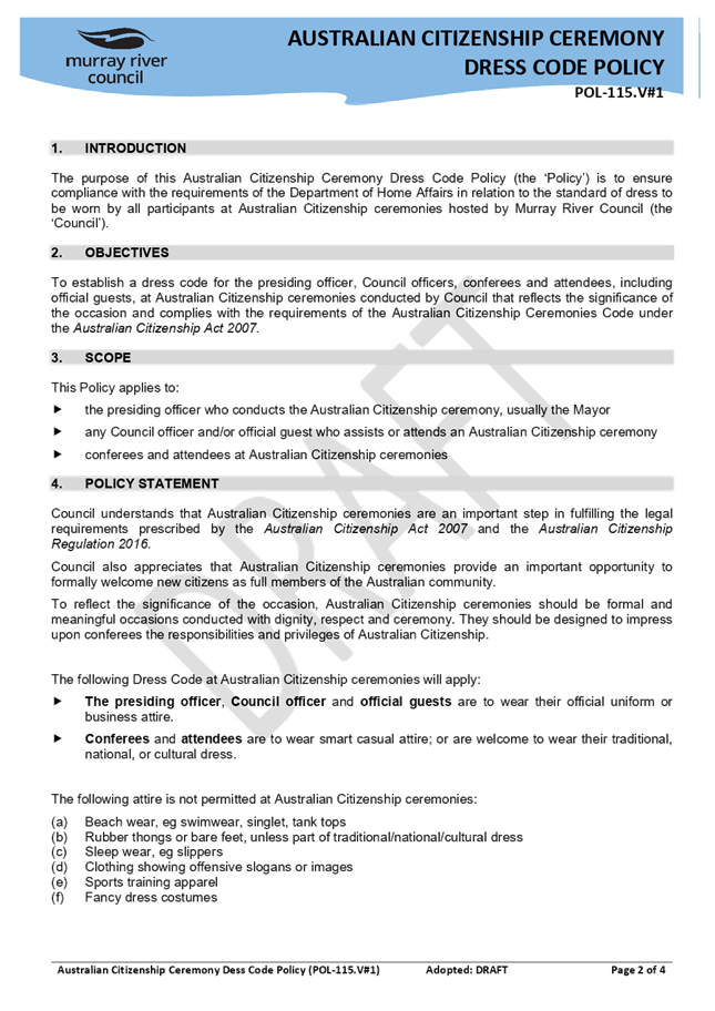
Background
The Australian
Citizenship Ceremonies Code (the ‘Code’) follows
the Australian Citizenship Act 2007 and sets out the legal and other
requirements for conducting citizenship ceremonies as well as the roles and
responsibilities for those involved in citizenship ceremonies.
A new version of the Code took
effect on 19 September 2019. Key changes are outlined below:
· Local
government councils must ensure ceremonies are conducted in accordance with the
Code. This includes a requirement to hold a citizenship ceremony on Australia
Day (January 26). Councils that conferred citizenship on less than 20
people in the previous year are exempt from this requirement;
· Federal
Members of Parliament, if attending a citizenship ceremony, should read the
Minister’s message; and
· Individual
councils are to establish a Dress Code for ceremonies, to reflect the
significance of the occasion, and provide a copy of their Dress Code to the
Department of Home Affairs.
Discussion
Murray River Council has not had a formal dress code for
conferees and attendees at Australian Citizenship ceremonies. The requirement
of a dress code has not been considered an issue for Council, with
approximately five (5) or less ceremonies held each year.
As per the new Code, which states on page 25:
The attire of attendees at
citizenship ceremonies should reflect the significance of the occasion.
A Dress Code
is to be set by individual councils.
Councils
must provide a current copy of their Dress Code to the Department of Home
Affairs.
a draft Murray River Council Australian Citizenship Ceremony
Dress Code Policy (the ‘Policy’) has been developed after reviewing
the Dress Code policies of neighbouring councils. The draft Policy recognises
the significance of a Citizenship Ceremony without imposing undue formality.
A copy of the draft Policy is attached (Attachment 1) for
the Council’s consideration and subsequent adoption.
Strategic Implications
5 - Strategic Theme 5: Leadership and Governance
5.1 - An effective, efficient and progressive Council that
provides leadership to the community
5.1.3 - Build and maintain strong partnerships and
relationships with all stakeholders especially our local communities, while
also building effective working relationships with our neighbouring councils
Budgetary Implications
Nil.
Policy Implications
Nil.
Legislative Implications
Australian Citizenship Act 2007.
Risk Analysis
· What
can happen?
A Dress Code for Australian
Citizenship Ceremonies is not adopted by the Council.
· How
can it happen?
Non-compliance with the
requirements of the Australian Citizenship Act 2007 and the Australian
Citizenship Ceremonies Code, which came into effect on 19 September 2019.
· What
are the consequences of the event happening?
As above.
· What
is the likelihood of the event happening?
Low to Zero.
· Adequacy
of existing controls?
Council staff
comply with all legal requirements when conducting Citizenship Ceremonies.
· Treatment
options to mitigate the risk?
As above.
Conclusion
The Australian Citizenship Ceremonies Code (the
‘Code’) follows the Australian
Citizenship Act 2007 and sets out the legal and other requirements for
conducting citizenship ceremonies as well as the roles and responsibilities for
those involved in citizenship ceremonies. A new version of the Code took
effect on 19 September 2019. One of the key changes for Council is that individual
councils are to establish a Dress Code for ceremonies, to reflect the
significance of the occasion, and provide a copy of their Dress Code to the
Department of Home Affairs.
Attachments
1. Murray
River Council Australian Citizenship Ceremony Dress Code Policy_DRAFT ⇩ 
|
MURRAY RIVER
COUNCIL Ordinary Council Meeting Agenda
|
26 May 2020
|
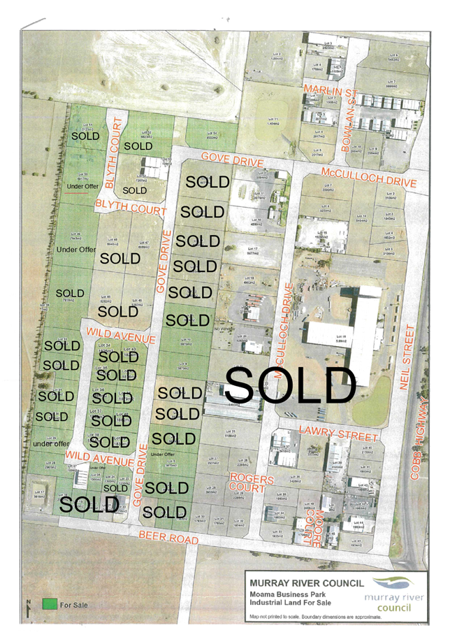
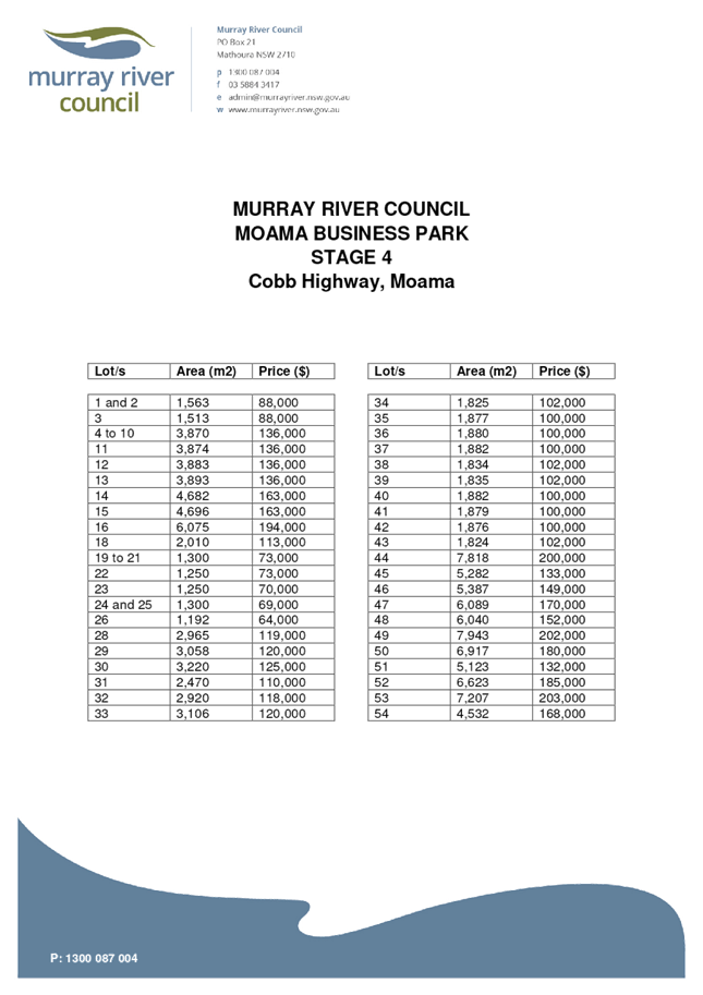
8.1.4 Sale of Lot 29, Wild
Avenue, Moama Business Park
File
Number: -
Author: John
Harvie, Manager Economic Development & Tourism
Authoriser: Des
Bilske, General Manager
|
Recommendation
That the Council:
1. Approves the sale of
Lot 29, Wild Avenue, Moama Business Park, Moama NSW 2731, to the purchaser at
the list price of $120,000 including GST on the following terms and
conditions:
(a) 10% down
payment on signing of contract.
(b) A
settlement period of 60 days.
(c) If not
developed within two (2) years, Murray River Council retains the right to
purchase the block back at the original price.
2. Approves
the execution of legal documents for the sale of Lot 29, Wild Avenue, Moama
Business Park, Moama NSW 2731 under the Common Seal of Council.
|
Background
Council has land available for purchase and development at
the Moama Business Park, Cobb Highway, Moama NSW 2731.
Discussion
Council has received an offer to purchase Lot 29, Wild
Avenue, Moama Business Park. The purchaser is agreeable to pay the current list
price of $120,000 including GST for the vacant lot.
Strategic Implications
4 - Strategic Theme 4: Economic Growth
4.1 - Encourage and support economic development across a
range of sectors
4.1.2 - Support the local business sector to grow, adapt and
respond to new opportunities
Budgetary Implications
Nil.
Policy Implications
Nil.
Legislative Implications
Nil.
Risk Analysis
· What
can happen?
Nil.
· How
can it happen?
Nil.
· What
are the consequences of the event happening?
Nil.
· What
is the likelihood of the event happening?
Nil.
· Adequacy
of existing controls?
Nil.
· Treatment
options to mitigate the risk?
NA.
Conclusion
Murray River Council encourages industry development as a
means to maintain population growth and stimulate local and regional economies
through jobs growth. Making suitable industrial land available for development
was a request made by members of our communities through the Community
Strategic Plan.
Attachments
1. Plan
of Available Land ⇩ 
2. Moama
Industrial Land - Price List ⇩
|
MURRAY RIVER
COUNCIL Ordinary Council Meeting Agenda
|
26 May 2020
|
|
MURRAY RIVER
COUNCIL Ordinary Council Meeting Agenda
|
26 May 2020
|
8.1.5 Murray River Council
Community Grants Program, 2019/20 - Round 2 allocation of funds
File
Number: -
Author: Beck
Hayward, Economic Development Officer
Authoriser: Des
Bilske, General Manager
|
Recommendation
1. That Council fund
the following projects under 2019/20 - Round 2 of its Community Grants
Program: ($30,000 has previously been
allocated, in the 2019/20 budget, to fund Round 2 of the 2019/20 Community
Grants Program.)
2. That council
allocate the additional $1,420 from the 2019/20 Quick Response Grant Funding.
|
Organisation Name
|
Project Title
|
Project
Cost
|
Amount Requested
|
Amount Recommended
|
|
Mathoura
Preschool
|
Portable Smart
Board
|
$3,000.00
|
$3,000.00
|
$3,000.00
|
|
Echuca-Moama
Field & Game Club
|
Bowman Clay Target
Trap
|
$3,650.00
|
$3,000.00
|
$3,000.00
|
|
Moama Anglican
Grammar
|
Keys to Success
|
$7,495.00
|
$3,000.00
|
$2,000.00
|
|
Koondrook Barham
Garden Society Inc.
|
Going Online
|
$3,000.00
|
$3,000.00
|
$1,000.00
|
|
Moulamein
Preschool Inc
|
Outdoor Cinema
Evening
|
$3,340.00
|
$2,940.00
|
$ 500.00
|
|
Mathoura Events
Committee
|
Portable AED
(Automated External Defibrillator)
|
$2,495.00
|
$2,495.00
|
$2,170.00
|
|
Barham Koondrook
PA&H Show Society Inc
|
Refrigerator for
Canteen
|
$1,700.00
|
$1,700.00
|
$1,700.00
|
|
Moama Echuca
Touch Football Association
|
Defibrillator
|
$2,170.00
|
$2,170.00
|
$2,170.00
|
|
Bar-rook
Sporting Field & Game
|
South Tower Trap
Upgrade
|
$4,350.00
|
$3,000.00
|
$3,000.00
|
|
Moama Historic
Vehicle Club
|
Equipment Update
for MHVC
|
$3,547.90
|
$3,000.00
|
$3,000.00
|
|
Bar-rook
Swimming Club Incorporated
|
Supporting Local
Youth & the Community
|
$2,800.00
|
$2,880.00
|
$2,880.00
|
|
Moama Cricket
Club
|
Extension of
Moama Cricket Nets Roof
|
$5,054.00
|
$3,000.00
|
$3,000.00
|
|
One & All
Inclusion Project
|
One & All
Debutante Ball
|
$13,510.00
|
$3,000.00
|
$1,000.00
|
|
Tooleybuc Preschool
Association Incorporated
|
Tooleybuc
Inter-generational Facility Feasibility Study
|
$3,000.00
|
$3,000.00
|
$3,000.00
|
|
TOTAL
|
|
|
|
$31,420
|
|
Background
Council ran the first round of
the Murray River Council Community Grants Program in September 2018 and
awarded $38,693.52 in grants.
At its 27 November 2018 meeting,
Council agreed to run two rounds per financial year, allocating $30,000 to each
round.
Round 2 of the 2019/20 Murray
River Council Community Grants Program opened in February 2020 and closed on 9
April with 25 applications received, seeking a total of $68,241 in grants.
The assessment panel, comprising
Councillors Crowe, Campbell and Wise and Council’s Manager Economic
Development & Tourism, John Harvie (delegate for Des Bilske, General
Manager), met on 7 May 2020 to review the applications received.
Discussion
The total amount of funding requested was $68,241 and there
is $30,000 available to grant in this round of the program.
There were many worthy projects submitted for consideration,
however with significantly less funding available than the amount requested,
the assessment committee had to closely consider the benefits of each project
for which funding was sought.
After consideration of the projects and assessment against
the criteria, the panel has agreed on a list of projects recommended for
funding.
The TOTAL value of the projects recommended for funding is
$59,111.90.
Strategic Implications
3 - Strategic Theme 3: Social Wellbeing
3.1 - Enable community access to services, programs and
facilities to support and enhance health, wellbeing, and community safety
3.1.5 - Plan for, provide, maintain, improve, and encourage
access to sporting facilities, recreational grounds, parks and gardens, natural
bushlands to create active and passive environments for enjoyment of residents
and visitors
Budgetary Implications
Council has allocated $30,000 per round for each of the two community
grant rounds per year, (as per 27 November 2018 resolution of Council). The
amount of funding recommended is slightly above the available $30,000. The
surplus $1,420 could be funded under Council’s Quick Response Grant,
should Council agree.
Policy Implications
Murray River Council Community Financial Assistance Policy
(POL109).
Legislative Implications
Council can financially assist others under s356 of the
Local Government Act 1993 (LGA), for the purpose of exercising its functions.
Also, under s377 (1A) of the LGA, Council may delegate its functions relating
to the granting of financial assistance if the financial assistance is part of
a specified program, and included in Council’s draft operational plan,
and does not exceed 5 per cent of Council’s proposed income from the ordinary
rates levied for that year.
Risk Analysis
· What
can happen?
1. There is a slight risk that
projects funded under the Community Grants Fund will not be delivered due to
resource or financial constraints experienced by a grant recipient.
2. There is a risk that there
may be some negative reactions from the unsuccessful applicants.
· How
can it happen?
1. Change of circumstance for the
applicant.
2. Frustrated applicants.
· What
are the consequences of the event happening?
1. Additional work and potential
changes to the scope of a project.
2. Relationships diminished
· What
is the likelihood of the event happening?
1. Low likelihood
2. Low likelihood
Adequacy of existing
controls?
1. Adequate
2. Adequate
· Treatment
options to mitigate the risk?
1. Council will seek to mitigate
this risk by working with community groups to support the delivery of their
project.
2. Council will seek to mitigate
this risk by communicating the high level of requests made and the Economic
Development team will work with these applicants to seek funding opportunities
elsewhere where possible.
Conclusion
The projects recommended are spread throughout the Council
area and across a variety of categories.
It would be both beneficial and judicious for Council to
allocate funds towards those projects recommended.
Attachments
Nil
8.2 Director
Corporate Services Report & Supplementary Matters
8.2.1 Financial
Statements & Investments as at 30 April 2020
File
Number: -
Author: Peter
Arthur, Contract Accountant
Authoriser: Ross
Mallett, Director Corporate Services
|
Recommendation
That:
1. The Officer’s report on
Council’s Financial Statements, Bank Reconciliations, and Investments
as at 30 April 2020 be received and noted by the Council.
2. The report detailing Council’s
position of $44,826,882.06 as at 30 April 2020 is received by the Council.
3. The report detailing Council’s
investment balance of $43,269,435.21 as at 30 April 2020 is received by the
Council.
|
Background
Discussion
Shown below are the Financial
Statements, Bank Reconciliations and Investments for the period ending 30 April
2020.
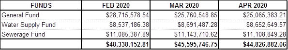
Statement of Bank Balances of Council’s Combined
Accounts as at 30 April 2020
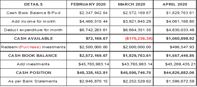
Internal Cashbook Balances
OVERDRAFT LIMITS: Bank
Overdraft - $650,000.00.
I hereby
certify that the cashbook of the various funds of Council has been reconciled,
with the appropriate Pass Sheets as at 30 April 2020.
Ross
Mallett
Responsible
Accounting Officer
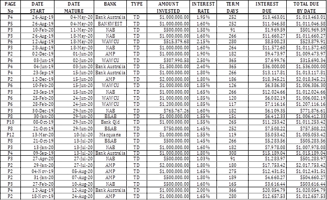
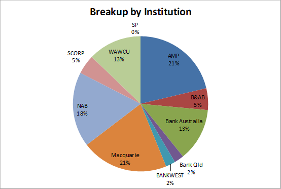
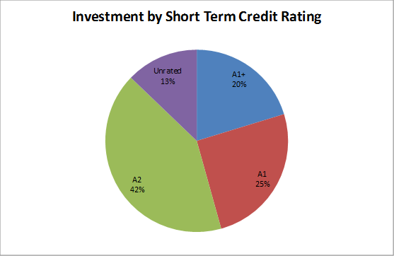
Investments as at 30 April 2020
As required by Section 212 of the Local Government (General)
Regulation 2005 and Section 625 of the Local Government Act 1993, the details
of Council’s surplus funds invested, totalling $43,269,435.21 are listed
below:

Strategic Implications
5 - Strategic Theme 5: Leadership and Governance
5.1 - An effective, efficient and progressive Council that
provides leadership to the community
5.1.2 - Council acts in a financially responsible manner to
ensure delivery of safe and sustainable services to the community
Budgetary Implications
Current low interest rates may reduce the expected interest
revenue.
Policy Implications
Investments have been made in accordance with the Council
Investment Policy which was adopted on the 17th October 2017.
Legislative Implications
Section 625 of the Local Government Act 1993
Regulation 212 of the Local Government (General) Regulations
2005
Trustees Act 1925 Section 14
Risk Analysis
· What
can happen?
Imprudent use of Council’s
financial resources.
· How
can it happen?
Not following investment rules,
policies or mandates.
· What
are the consequences of the event happening?
Potential loss of financial
resources.
· What
is the likelihood of the event happening?
Low.
· Adequacy
of existing controls?
Good.
· Treatment
options to mitigate the risk?
Responsible management of
financial resources invested in accordance with Council’s investment
policies and mandate.
Conclusion
Murray River Council’s liquidity is in a satisfactory
position as at 30 April 2020, although there is a downward trend.
Attachments
Nil
8.3 Director
Engineering Report & Supplementary Matters
8.3.1 Major
Projects Progress Update
File
Number: -
Author: Diane
Cottrell
Authoriser: Scott
Barber, Director Engineering
|
Recommendation
That the Council receives and notes the Officer’s report on the Major
Projects Progress Update as at 18 May 2020.
|
purpose
To inform elected officials and the community on the
progress of externally funded “one-off” major projects.
PROJECT – UPDATES
As we ease out of COVID19
restrictions, we will review the recommencement date of the Culture Improvement
and Business Excellence programs originally on hold until July 2020. The
Enterprise Resourcing Planning System tender has closed. Of the four providers
invited to tender we received three submissions that are now in the evaluation
process. We aim to have this complete by the end of June 2020.
The Moulamein Pre-School
is entering the defect stage, as building contract works are complete. Moama
Recreation Reserve Zone 1 – Stage 1 Pavilion is ready for handover with
the Stage 2 grandstand running ahead of schedule. Both projects should complete
by the end of this financial year with Barham Rec Reserve Pavilion Stage 1 not
far behind – due 22 July although tracking ahead of schedule.
The Smart Water Meters
project is making great progress with the replacement meter rollout. The site
for the second receiver tower in Moama has been identified and the MiWater
system training has commenced. We are currently branding the MiWater
application and conducting user acceptance testing. To find out more about this
project please register and sign in to Your Say Murray River our new engagement
online platform.
There’s not a great
deal of movement reported under Regional Growth Fund Round 1 as Tooleybuc
Mensforth Park and Murray Downs Riverbank Park consultations were delayed due
to COVID19 and the construction works on the Moama Foreshore Development
projects scheduled to commence in the next financial year when we should see
significant progress.
As reported last month,
Stage 1 of the RMS-AESP Moama – Barmah Road Pedestrian Facility works at
the Cummergunja Aboriginal Community is complete and has now been removed from
this report. Reporting will recommence from September 2020 when Stage 2 kicks
in.
The table overleaf shows the status of the projects reported
here.
Twenty of the thirty-eight projects reported are complete
and the remainder on track with the exception of Barham Pontoon that has an
extension approved by the funding body.
|
Stage
|
SCF1
|
SCF2
|
SCCF1
|
SCCF2
|
RGF1
|
MRC
|
TOTAL
|
|
Number of projects
|
9
|
7
|
7
|
7
|
6
|
2
|
38
|
|
Start-up
|
|
1
|
|
|
|
|
3%
|
|
Scoping
|
|
|
|
|
1
|
|
3%
|
|
Design
|
|
|
|
|
3
|
|
8%
|
|
Planning
|
|
|
|
|
|
|
0%
|
|
Procurement
|
|
1
|
|
|
|
|
3%
|
|
Construction
|
4
|
1
|
1
|
4
|
2
|
1
|
33%
|
|
Complete
|
5
|
4
|
6
|
3
|
|
1
|
50%
|
|
Summary
|
|
|
% in progress
|
44%
|
43%
|
14%
|
57%
|
100%
|
100%
|
|
|
% complete
|
56%
|
57%
|
86%
|
43%
|
0%
|
0%
|
|
|
Variation to budget of the 18
completed projects
|
|
% under budget
|
80%
|
86%
|
71%
|
100%
|
n/a
|
n/a
|
|
|
% over budget*
|
20%
|
14%
|
29%
|
0%
|
|
*Council holds uncommitted funds within each of the
funding streams to allocate to budget variations within the same stream, which
provides a degree of flexibility to manage project budgets. Council funds any
variations to scope on Council funded projects, such as the Moama HQ.
|
MURRAY RIVER
COUNCIL Ordinary Council Meeting Agenda
|
26 May 2020
|
|
Program
Status – Stronger Communities Fund Round 1 (SCF1)
|
SCF1 $9,000,000
OTHER $703,606
|
Projects
9
|
|
 Program
Health Program
Health
|
 Program
Trend Program
Trend
|
 Actual
Spend / Budget Actual
Spend / Budget
|
 At
Risk Projects At
Risk Projects
|
 Last
Updated Last
Updated
|
|
|
|
 Moama Rec Reserve Moama Rec Reserve
Pavilion Zone 1
Stage 1
Status On
track
Stage Construction
Budget $3,965,600 SCF1
Actual $$ 85%
- SCF1
|
 Barham Rec Reserve Barham Rec Reserve
Multi-functional Pavilion Stages 1 & 2
Status On
track
Stage Construction
Budget $2,000,000 SCF1
$186,811000
MRC
$100,000 AFL
Actual $$ 92%
of SCF1 fund
|
Merran Creek Bridge
Moulamein Swan Hill Road
 Status Complete Status Complete
Stage Closure
Budget $525,000 SCF1
$342,000 MRC
Actual $$ 100%
- SCF1
100%
- MRC
|
Tooleybuc Mensforth Park
Upgrade
Status On
track
Stage Construction
Budget $650,000 SCF1
$300,000 RGF1
Actual $$ 100%
- SCF1
now being reported under RGF1
|
Mathoura Rec Reserve
Pavilion Ext, Kitchen & Bar
Status Complete
Stage Closure
Budget $541,420 SCF1
$44,436 MRC
Actual $$ 100%
- SCF1
100%
- MRC
|
|
Barham Rec Reserve
Skate Park
Status Complete
Stage Closure
Budget $407,000 SCF1
Actual $$ 91%
- SCF1
|
Moulamein Pre-School
Status Constructions
Stage Defect
stage
Budget $410,812 SCF1
$13,353 MRC
Actual $$ 100%
- SCF1
100%
- MRC
Over budget –
reallocation of funds to be approved
|
Moulamein South Rec Reserve
Upgrade
Status Complete
Stage Closure
Budget $360,812 SCF1
Actual $$ 81%
|
Mathoura Picnic Point Reserve
Improvements
Status Complete
Stage Closure
Budget $200,000 SCF1
Actual $$ 81%
|
|
|
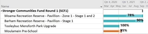
Comments: Moama Recreation Reserve
Pavilion Stage 1: Stage 1 95%
complete. Pre-hand over inspection on 19 May 2020. Handover from contractor
scheduled 22 May 2020. Stage 2 – grandstand is 65% complete and ahead
of schedule. Concrete being poured and coaches box 80% complete.
Barham Recreation Reserve Pavilion Stages 1: Due to complete 27 July
2020. Scoping and costing additional work to Stage 1. Tooleybuc
Mensforth Park Stage 1: Defect rectification in progress. Stage 2 in
progress – see RGF1 Moulamein Pre-School Stage 1: Building
contracted works complete awaiting defect inspection.
|
|
Program
Status – Stronger Communities Fund Round 2 (SCF2)
|
SCF2 $4,095,000
MRC
$32,157
|
Projects
7
|
|
Program Health
|
Program Trend
|
 Actual
Spend / Budget Actual
Spend / Budget
|
At
Risk Projects
|
 Last
Updated Last
Updated
|
|
|
|
MRC Culture / Bus Excellence F/work / Enterprise System
Status On
track
Stage Delivery
Budget $1,500,000 SCF2
Actual $$ 9%
- SCF2
|
Moama Business Park Expansion
Status Watching brief
 Stage Start-up Stage Start-up
Budget $1,195,000 SCF2
Actual $$ 0%
- SCF2
|
Moama Business Park Upgrade Water Pressure Pump
 Status On
track Status On
track
Stage Procurement
Budget $500,000 SCF2
Actual $$ 13%
- SCF2
|
Moama Council New Office
Car Park Upgrade
Status Complete
Stage Closure
Budget $250,000 SCF2
Actual $$ 100%
- SCF2
|
Barham Bridge Road Access
Status Complete
Stage Closure
Budget $250,000 SCF2
$32,157 MRC
Actual $$ 96%
|
|
Moama Recreation Reserve
Road Sealing and Drainage
Status Complete
Stage Closure
Budget $200,000 SCF2
Actual $$ 96%
|
Tooleybuc Rec Reserve
Irrigation System Upgrade
Status Complete
Stage Closure
Budget $200,000 SCF2
Actual $$ 83%
|
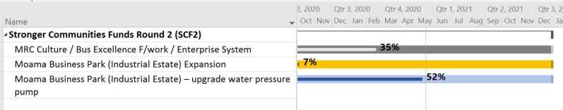
Comments:
MRC ERP tender closed and evaluation in progress. Culture Business
Unit debrief and action planning to recommence in July. Process mapping to be
scheduled.
Moama Business Park Pump Upgrade: Material order placed. Civil construction
to be awarded week commencing 18 May 2020 to commence 25 May 2020.
Exceptions: Moama Business Park expansion: Alternative scope in
progress
|
|
Program Status – Stronger Country Communities
Fund Round 1 (SCCF1)
|
SCCF1 $2,049,463
MRC $54,891
RGF1 $530,000
|
Projects
7
|
|
Program Health
|
Program Trend
|
 Actual
Spend /Budget Actual
Spend /Budget
|
At
Risk Projects
|
 Last
updated Last
updated
|
|
|
|
 Barham Pontoon Barham Pontoon
Status Under
investigation
Stage Construction
Budget $505,000 SCCF1
$200,000 RGF1
Actual $$ 68%
- SCCF1
|
Tooleybuc Pontoon
Status On
track
Stage Construction
Budget $505,000 SCCF1
$330,000 RGF1
Actual $$ 100%
- SCCF1 fund
Remaining works reported under RGF1
|
Moama Rec Reserve Zone 4
Lights/Criterion Track/L’scape
Status Complete
Stage Closure
Budget $384,294 SCCF1
Actual $$ 70%
- SCCF1
|
Murray Downs Path Stage 1
Status Complete
Stage Closure
Budget $80,960 SCCF1
Actual $$ 96%
- SCCF1
|
Tooleybuc Rec Reserve
Amenities Building
Status Complete
Stage Closure
Budget $120,206 SCCF1
$40,794 MRC
Actual $$ 100%
- SCCF1
100%
- MRC
|
|
Moulamein Swimming Pool
Reline
Status Complete
Stage Closure/defect
Budget $133,975 SCCF1
$14,097 MRC
Actual $$ 104%
- SCCF1
100%
- MRC
|
Barham, Bunnaloo, Koraleigh, Mathoura, Wakool Courts
Status Complete
Stage Closure
Budget $320,028
SCCF1
Actual $$
91%
|
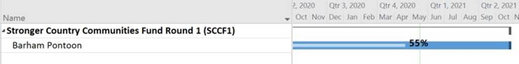
Comments:
Barham Pontoon Extension of time
to 23 July 2020 was approved. Next steps -new gangway detailed design.
Tooleybuc Pontoon: the SCCF1 fund acquitted. Remaining works reported under
RGF1 funding.
NB: Overall actual spend to budget correct pending funding body
approval to repurpose savings to cover overspends
|
|
Program Status – Stronger Country Communities
Fund Round 2 (SCCF2)
|
SCCF2
$2,624,555
|
Projects
7
|
|
Program
Health
|
Program
Trend
|
 Actual
Spend / Budget Actual
Spend / Budget
|
At
Risk Projects
|
Last
updated
|
|
|
|
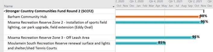
Barham Community Hub Stage 1
Status On
track
Stage Construction
Budget $828,411 SCCF2
Actual $$ 87%
|
Moama Rec Reserve Zone 2
Lighting/car park/Eddy Oval
Status On
track
Stage Construction
Budget $736,411 SCCF2
Actual $$ 95%
|
Moama Rec Reserve Zone 3
Off leash area
Status On
track
Stage Construction
Budget $266,1025 SCCF2
Actual $$ 70%
|
Moulamein South Rec Reserve
Resurface/lights/shed/courts
Status On
track
Stage Construction
Budget $347,310 SCCF2
Actual $$ 80%
|
Murray Downs
Exercise track/equipment
Status Complete
Stage Defect
stage
Budget $174,023 SCCF2
Actual $$ 68%
|
|
Tooleybuc Mensforth Park
Footpath and Lighting
Status Complete
Stage Closure
Budget $117,023 SCCF2
Actual $$ 73%
|
Playgrounds
Status Complete
Stage Defect
stage
Budget $255,473 SCCF2
Actual $$ 81%
|
Comments:
Barham Community Hub: Defect inspection complete and works in progress.
Installation of fence, handrail and step will complete the project. Costing
for signage and landscaping in progress. Moama Recreation Reserve Zone 2:
in defect period, rectification of lights to be arranged. Awaiting
confirmation of funding reallocation to expand scope of works. Zone 3 -
Furniture fully installed along with compliance signage. Still to be done -
driveway, car parking which has commenced and due for completion by end of 22
May 2020 (rain delayed) Moulamein South Recreation Reserve: Slab prep
for shed complete and due to be poured w/c 18 May 2020. Pre-fabricated shed
due onsite w/c 18 May 2020. Contractor engaged to install from 25 May 2020 to
complete work
|
|
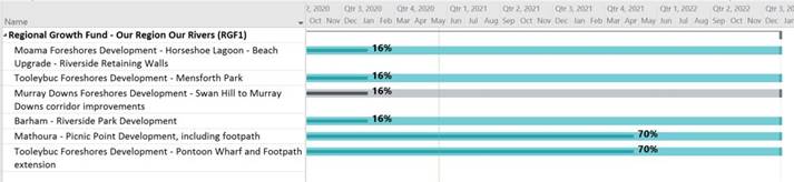
Program Status – Regional Growth Fund (Our
Region our Rivers)
(RGF1) 50/50
funding with MRC/SCF1/SCCF1&2
|
RGF1
$2,007,696
MRC
$751,271
|
Projects 6
|
|
Program
Health
|
 Program
Trend Program
Trend
|
 Actual
Spend /Budget Actual
Spend /Budget
|
At
Risk Projects
|
 Last
updated Last
updated
|
|
|
|
Moama Foreshore
Development
Horseshoe
Lagoon, Beach Amenities Block and Riverside Retaining Wall
Status On
track
Stage Design
and approval
Budget $751,271 RGF1
$751,271 MRC
Actual $$ 0%
|
Tooleybuc Foreshore
Development
Mensforth Park
Status On
track
Stage Design
and approval
Budget $300,000 RGF1
Actual $$ 40%
- RGF1
|
Murray Downs Foreshore
Development
Riverbank Park
Status On
track
Stage Design
and approval
Budget $117,925 RGF1
Actual $$ 4%
|
Barham Riverside Park
Development
Status On
track
Stage Scope
Budget $171,000 RGF1
Actual $$ 0%
|
Mathoura Picnic Point
Development (footbridges)
Status On
track
Stage Construction
Budget $137,500 RGF1
$137,500 SCF1
Actual
$$ 100%
- RGF1
|
|
Tooleybuc Foreshore
Development
Pontoon
Status On
track
Stage Construction
Budget $330,000 RGF1
$505,000 SCCF1
acquitted
Actual $$ 38%
- RGF1
|
Comments:
Moama Foreshore - Horseshoe Lagoon and Riverside
Retaining Wall: to commence
FY2020-21 Beach Amenities Block: Drafting of Specification for
procurement of Removable toilet unit (similar to MacLean’s Beach
Deniliquin adopted) and RFQ for water and sewerage, and power design in
progress. Next - Preconstruction activities this financial year and
supply and installation, next financial year.
Tooleybuc Mensforth Park: Community consultation on final design delayed due
to COVID-19
Murray Downs Foreshore: Community consultation on final design delayed
due to COVID-19
Barham Riverside Park: Architect appointed to conduct design for bank
stabilisation
Mathoura Picnic Point: Footbridges complete, next steps to develop
scope of works for footpath and appoint contractor
Tooleybuc Pontoon: Septic tank design complete. Some movement in
application for power connection causing delay. Next steps Install the
sceptic tank then connect power. Council to consider proposal submitted for
easier small boat access.
|
|
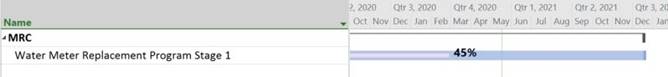
MRC – Moama Office Refurbishment
MRC – Smart Water Meter Replacement Program
|
MRC $4,800,000
|
Projects 2
|
|
|
Program Health
|
Program
Trend
|
 Actual
Spend /Budget Actual
Spend /Budget
|
At
Risk Projects
|
Last
updated
|
|
|
|
|
|
Water Meter Replacement Program
Stage 1
Status On
track
Stage Construction
Budget $2,900,000 MRC
Actual $$ 37%
|
Moama HQ refurbishment
Stage 1
Status Complete
Stage Defect
stage
Budget $1,900,000 MRC
Actual $$ 100%
|
Comments:
3381 x V200HT meters. Site identified for 2nd receiver in Moama.
MiWater remote training sessions underway. UAT plans received to be
progressed.
Next steps: Complete MiWater training sessions. Continuation of Meter
installations by addressing COVID-19 Risks. Planning installation of second
Receiver in Moama to cover for blackspot. Work in progress for getting
approval by 27th of May for the ordering of 2,408 additional Aquiba meters.
Compile requirements for MiWater Public Portal
|
|
|
|
|
|
|
|
|
|
MURRAY RIVER
COUNCIL Ordinary Council Meeting Agenda
|
26 May 2020
|
CONCLUSION
Projects are tracking well with the team preparing
variations for the Stronger Country Community Funds round one and two for
extensions to timeframe, scope and repurposing of funds.
Remember to register, sign in and participate on Your Say Murray River and
encourage other community members to do the same.
Please advise if you would like to see any changes to this
report or if there is anything missing.
Attachments
Nil
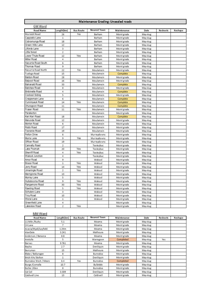
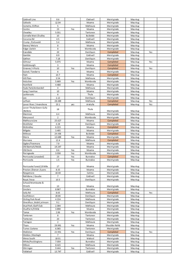
8.3.2 Unsealed Road
Maintenance Schedule - May to August 2020
File
Number: -
Author: Frederik
Groenewald, Manager Engineering Operations
Authoriser: Scott
Barber, Director Engineering
|
Recommendation
That the Council notes
the current forecast maintenance for 136 roads inspecting and repairing
sections of Murray River Council’s unsealed roads for the period May to
August 2020.
|
Background
In order to update and upgrade the Murray River Council road
service network, Council schedules to undertake roadworks and maintenance
grading on unsealed roads. The frequency of upgrades depends on factors such as
frequency of use, location, types of use and other services such as bus routes.
Discussion
Most of the scheduled road maintenance is completed on
Council’s 136 unsealed roads as attached to this report is the three
month current forecast until August 2020.
The scheduling is flexible and may change due to weather
conditions, unplanned maintenance matters and/or other emergency works.
This year Council plans to undertake maintenance on sections
within 1340km of unsealed roads.
Strategic Implications
1 - Strategic Theme 1: Built/Physical Environment
1.2 - Improve and maintain our road and transport network
1.2.1 - Develop long-term plans for maintenance and
construction of town streets and the rural road network - with priorities
established in conjunction with the community
Budgetary Implications
Funding is ongoing and recorded within Murray River
Council’s annual budget.
Policy Implications
Murray River Council Asset Management Policy (POL305)
Murray River Council Transport Assets Management Policy
(POL300)
Legislative Implications
Roads Transport Act 2013.
Roads Act 1993.
Local Government Act 1993.
Risk Analysis
· What
can happen?
If roads are not maintained, there
is a greater risk of collision, property damage, injury and customer
dissatisfaction.
· How
can it happen?
Poor quality roads.
· What
are the consequences of the event happening?
Higher risk of
damage and/or injury.
· What
is the likelihood of the event happening?
High when roads
are not maintained.
· Adequacy
of existing controls?
Good.
· Treatment
options to mitigate the risk?
Continue to schedule and re-visit
to update the schedule for unsealed roads upgrade.
Conclusion
That Council notes that the report incorporating the
schedule for unsealed roads maintenance and upgrade has been received.
Attachments
1. Rural
Roads Maintenance List - May to August 2020 ⇩ 
|
MURRAY RIVER
COUNCIL Ordinary Council Meeting Agenda
|
26 May 2020
|

8.4 Director
Planning, Waste & Regulatory Services Report & Supplementary Matters
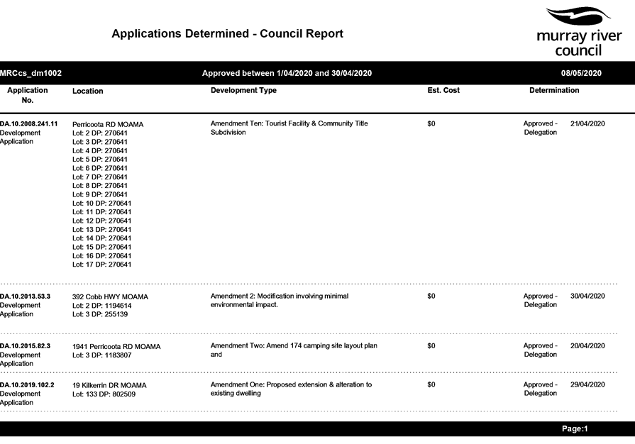
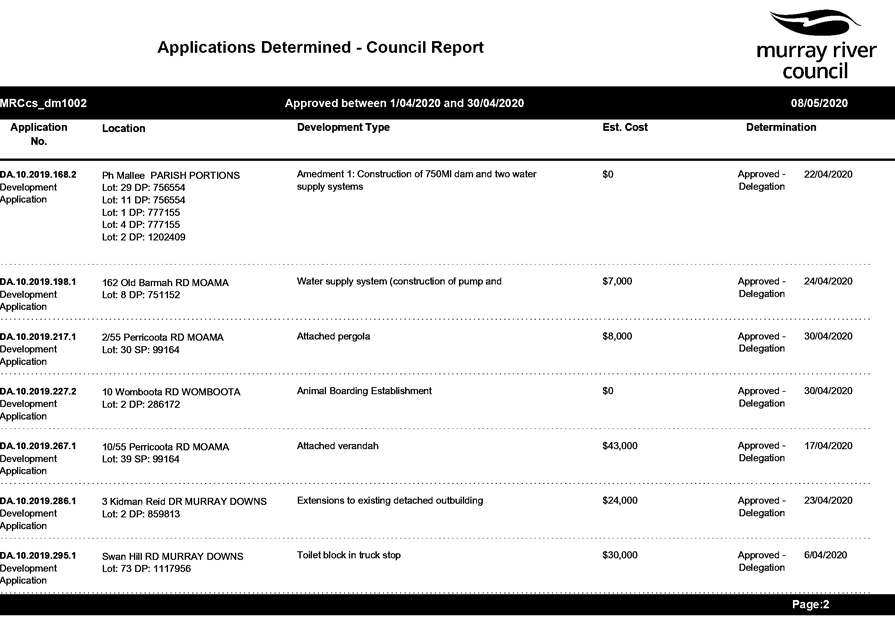
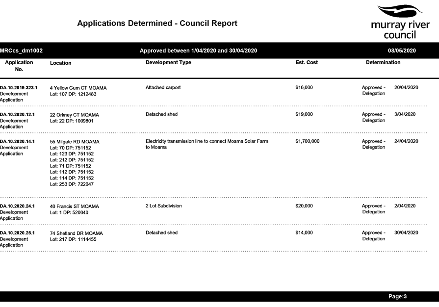
8.4.1 Planning,
Waste & Regulatory Services Directorate - Monthly Activity Report
File
Number: -
Author: David
Wilkinson, Director Planning, Waste & Regulatory Services
Authoriser: Des
Bilske, General Manager
|
Recommendation
That the Planning, Waste & Regulatory Services Directorate
- Monthly Activity Report for the period 1 April to 30 April 2020 be received and the
information noted by the Council.
|
Discussion
This report details the activities of Council’s
Planning, Waste & Regulatory Services Directorate from 1 April to 30 April
2020.
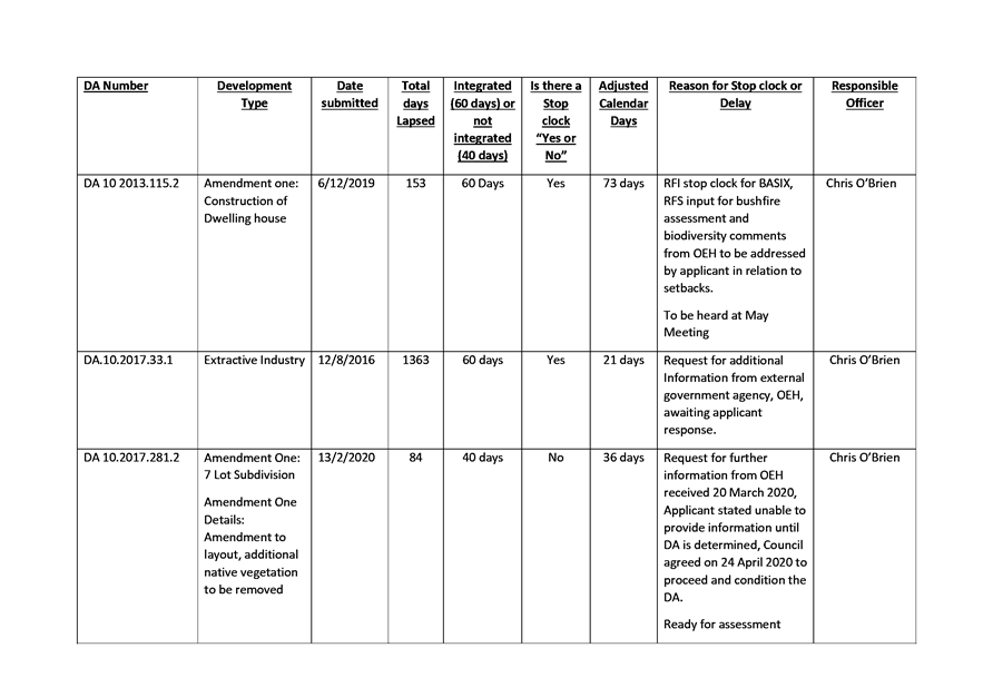
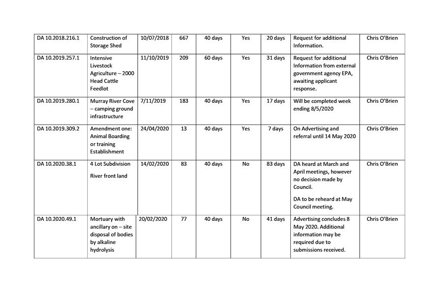
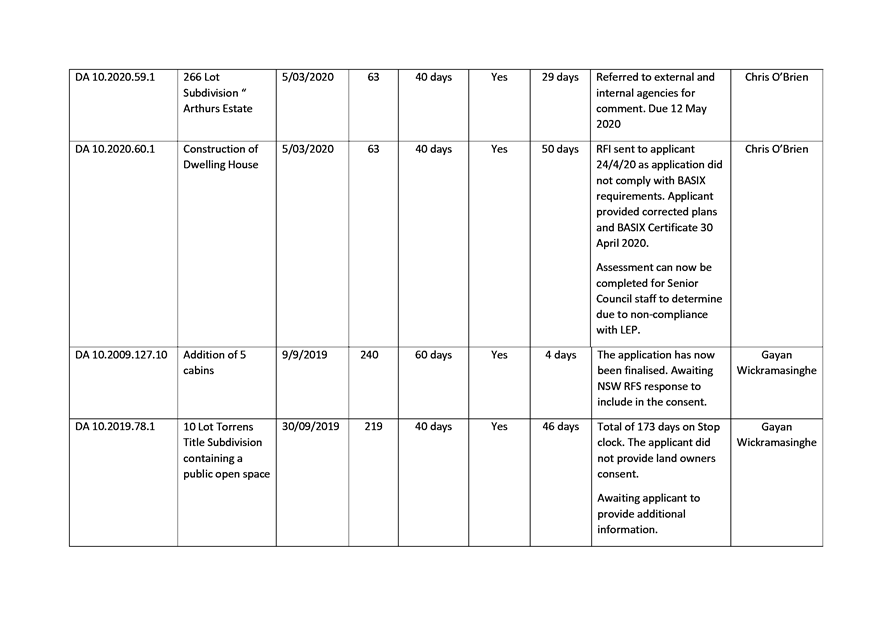
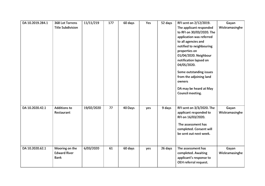
Attachments
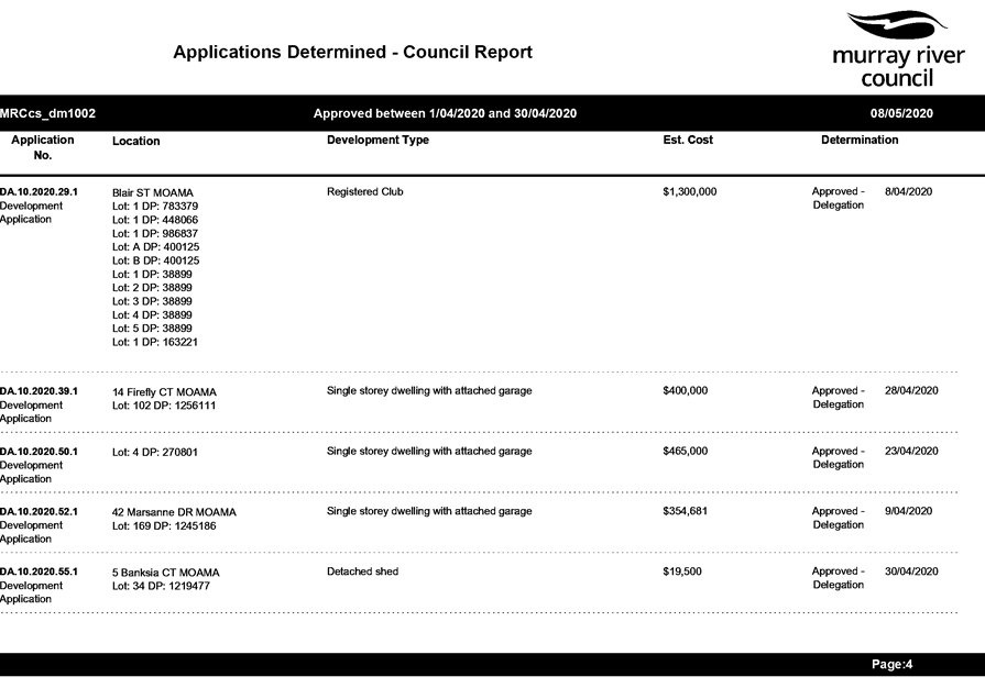
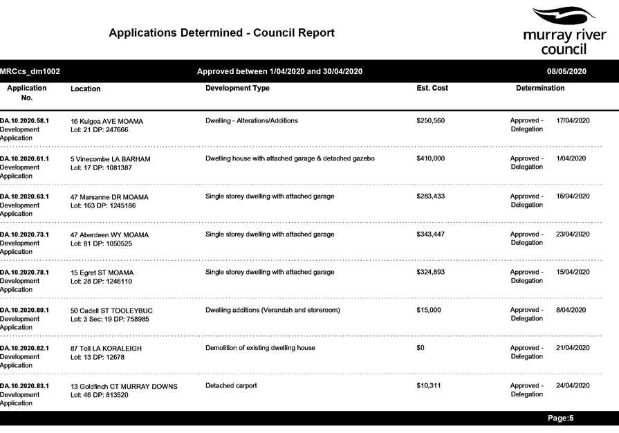
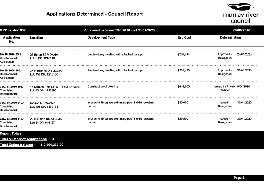
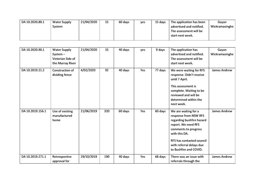
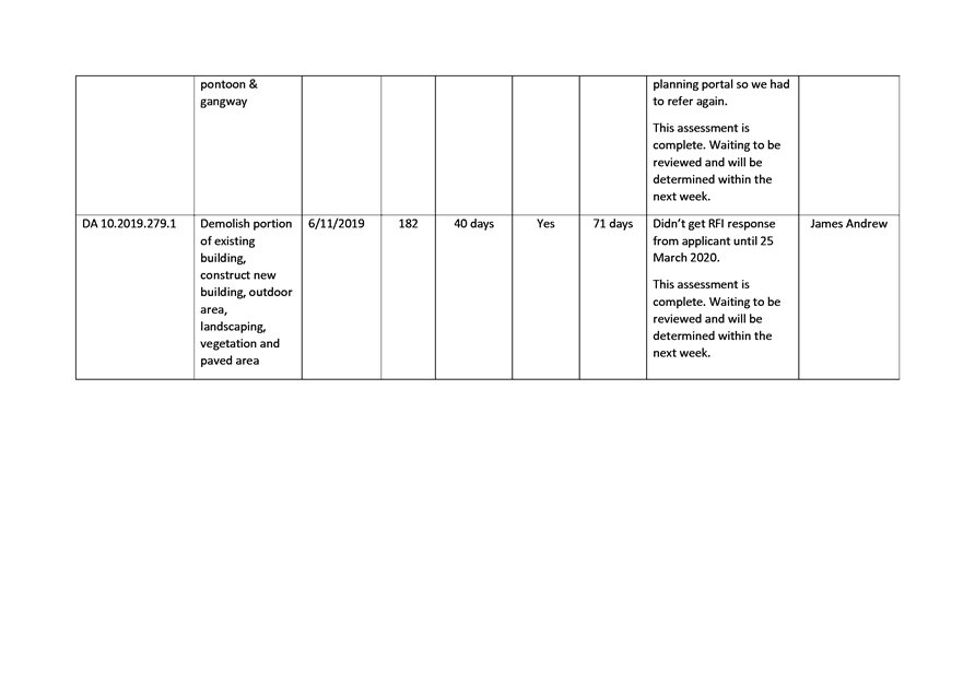
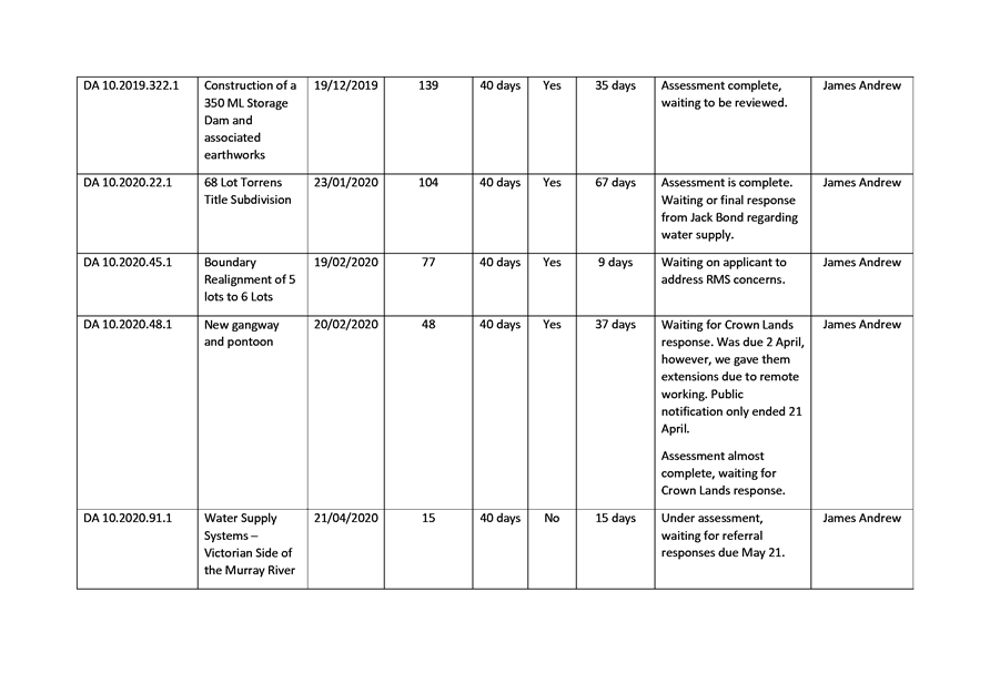
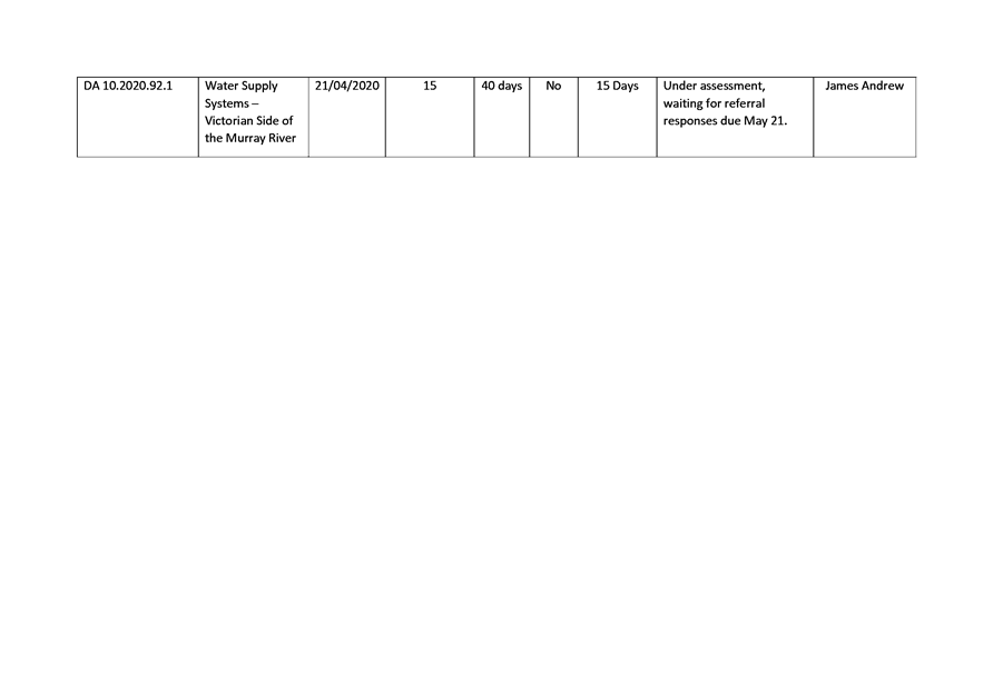
1. Applications
Determined under Delegated Authority - 1 April to 30 April 2020 ⇩ 
2. Application
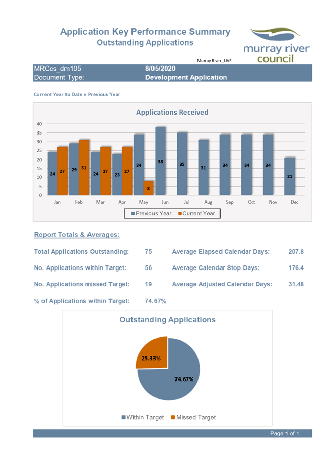
Key Performance Summary – Outstanding Applications - April 2020 ⇩ 
3. DA
Performance Report - April 2020 ⇩ 
4. Compliance
Report - April 2020 ⇩
5. Waste
Report - April 2020 ⇩
|
MURRAY RIVER
COUNCIL Ordinary Council Meeting Agenda
|
26 May 2020
|
|
MURRAY RIVER COUNCIL Ordinary
Council Meeting Agenda
|
26 May 2020
|
|
MURRAY RIVER
COUNCIL Ordinary Council Meeting Agenda
|
26 May 2020
|
|
MURRAY RIVER COUNCIL Ordinary
Council Meeting Agenda
|
26 May 2020
|
|
MURRAY RIVER COUNCIL Ordinary
Council Meeting Agenda
|
26 May 2020
|
8.4.2 Murray River Council
Draft Local Strategic Planning Statement - Post Consultation Update
File
Number: -
Author: Llyan
Smith, Senior Town Planner
Authoriser: David
Wilkinson, Director Planning, Waste & Regulatory Services
|
Recommendation
That the Officer’s report on Murray River Council Draft
Local Strategic Planning Statement - Post Consultation Update as at 29 April
2020 be received
and the information noted by the Council.
|
Discussion
The Murray River Council Local Strategic Planning Statement
(LSPS) sets out the 20-year vision for land use planning in Murray River
Council, outlining how growth and change will be managed to encourage economic
growth, and maintain the high levels of environmental amenity, liveability and
landscape quality that characterises our area. It identifies the special characteristics
that contribute to Murray River Council’s local identity and recognises
the shared community values to be maintained and enhanced.
At the Council meeting held 24 March 2020,
Council resolved to:
· Provide
approval of the Draft Murray River Council Local Strategic Planning Statement.
· Proceed
to public consultation for the Draft Local Strategic Planning Statement in
accordance with the approved Communication and Engagement Plan.
Due to the COVID 19 crisis restriction in place at the time
the draft was exhibited, Council could not engage as originally planned with
physical community workshops and information sessions. All consultation for
this draft was subsequently carried out online, largely via the Your Say Murray
River Portal. The draft was publicly exhibited from 26 March 2020 until 29
April 2020 using the following methods:
· Written
correspondence to Developer Forum attendees
· Written
correspondence to neighbouring Councils, local and State Agencies and referral
bodies
· Advertised on
Council’s website
· Advertised on
Local newspapers
· Media releases
· Social media
· Your Say Murray
River online portal.
Council received a fantastic level of community engagement
to the draft document, with the following response received:
· 453 total visits
to our Your Say Murray River LSPS page
· 20 External
submissions (via online submission tool and direct email)
· 1
‘Question’ loaded to the LSPS page for response
· 75 Map Pins dropped
on our map tool from 20 contributors. The pins were grouped into the following
three categories:
o “My big idea”
o “What I like/would like
to keep”
o “What I would like to
change”
A table setting out a summary of submissions and
Council’s response to each has been included here as Table 1. It is noted
that only the submissions received during the consultation period are included
in this table. Council did receive preliminary contact from a number of
parties, whose comments have been taken into consideration as part of the draft
released for public consultation.
Map Pins using the Your Say Portal generated a corresponding
GPS coordinate, however for the purposes of this report the location of the pin
has been identified using locality, and an address where available. A copy of
itemised Pin locations can be provided to Councillors upon request, together
with a Summary Report of activity recorded by the Your Say LSPS Portal. A full
copy of all original submissions can also be provided upon request.
THEME 1 - A ROBUST, GROWING AND INNOVATIVE ECONOMY
Planning Priorities
1. Grow, strengthen and sustain agriculture
2. Grow and strengthen tourism
3. Create an ‘open for business’
identity
THEME 2 - LIVEABLE COMMUNITIES WITH SOCIAL CAPITAL
Planning Priorities
4. Housing growth, supply and density
5. Recreation and open space
6. Servicing and utility infrastructure
THEME 3 - ENVIRONMENT, HERITAGE AND CLIMATE CHANGE
Planning Priorities
7. Identify and protect environmental values
8. Celebration of culture and heritage
9. Climate change and natural hazards
Table 1 – LSPS Submissions
summary
|
External Submissions
|
|
Ref.
|
Locality &
LSPS Theme
|
Matters raised by submission
(see Annexure # for full submission)
|
Council comments
|
|
EX.1
|
Council wide
Theme 2
Liveable communities
Theme 3
Environment, Heritage and Change
|
The following advice is provided
“…Theme 2 - Priority 4 - Housing growth,
supply and density
The preparation of a Strategic Bush Fire Study
(SBFS), as part of the preliminary studies undertaken for a planning
proposal, shall be carried out where land is located in proximity to bush
fire risks. The SBFS shall be in accordance with the Strategic Planning
Principles of Planning for Bush Fire Protection 2019 (PBP19) to ensure only
appropriate development occurs in areas where bush fire hazards exist.
NOTE: the SBFS addresses a number of considerations
which should inform the suitability of a site (and its surrounding location
in the landscape) for the proposed land uses in consideration of strategic
access networks, proposed densities and likely internal and external impacts
as a result of bush fire impacts. The SBFS should address the contents of
Table 4.2.1 of PBP19…”
|
The LSPS outlines that Council will continue to locate residential
development away from known hazard wherever possible. However,
acknowledgement of advice to require a Strategic Bush Fire Study for planning
proposals which are located in proximity to bushfire risks is noted.
Council will continue to adhere to the applicable Planning Directions for the
assessment of planning proposals effected by bush fire prone land mapping,
and require a suitable assessment against bushfire risk at development application
stage.
The current review of bushfire prone land mapping in collaboration
with RFS will be finalised and updated as per Action 9.3. This will enable
Council to better identify the applicable planning proposals which require
preparation of a Strategic Bush Fire Study.
|
|
EX.2
|
Mathoura
Council wide
Theme 2
Liveable communities
|
The LSPS does not include site specific rezoning of the submission
maker’s private property to achieve multi-dwelling housing, as
previously discussed with Council since 2015.
The LSPS does cater for housing strategy to meet the needs of our
aging population
|
The applicant was contacted by staff to discuss their concerns. It
was noted at the time that the LSPS forms the highest tier of planning
strategy for Murray River Council and will be used to inform lower tier (more
specific) strategies, such as Land Use Strategy, and housing strategies that
will plan for residential form in our towns and villages. The LSPS in itself
cannot specifically advocate for lot specific LEP changes which do not
already have endorsed strategic backing. Council will be creating housing
strategy (see Action 4.1-4.5 of Priority 4) to identify and plan for housing
growth, supply and density and this site specific proposal will be considered
at that time.
Priority 4 of the LSPS acknowledges that we need to provide suitable
housing variety for our aging population and flags that there have been
interest in the provision of retirement villages and aged care facilities
within Moama, Barham and Mathoura. To achieve our vision, key actions of the
LSPS are to deliver housing choice with varying densities and forms to meet
the varying needs of our changing demographics. Multi dwelling housing can be
investigated as part of our housing strategy.
|
|
EX.3
|
Council wide
Theme 2
Liveable communities
|
Concern that Council would be considering existing strategies to
inform our new direction
|
The submission maker was contacted by staff to discuss their
concerns. It was noted at that time that while some strategy is no longer
relevant or fit for purpose, there are some strategies which may hold future
value. For instance, Moama’s growth is projected to extend along the
current north-west development corridor, as such, the Moama North-West Master
Plan and the Moama Mid-West Drainage Strategy remain relevant and should be
assessed as part of our housing strategy investigations for Moama. Council understands
that this may not be the case for all existing strategy across Council,
however this will not be known definitively until we have considered these
existing strategies on their merits.
|
|
EX.4
|
Barham
Theme 1
Economy
|
The submission maker requests that Council consider a site specific
rezoning at Lot 121 DP 1094887, which is currently zone R5 Large Lot
Residential, however has been operated as a timber processing facility
(sawmill) since 1975. The submission maker is unaware of any consultation that
was carried out with them as owners prior to the rezoning to R5 in around
2013. The submission maker requests that Council rezone the site to
industrial, or a zoning that allows the use of the existing buildings and
facilities to support the future development opportunities for Barham.
|
The applicant was contacted by staff to discuss their concerns. It
was noted at the time that the LSPS forms the highest tier of planning
strategy for Murray River Council and will be used to inform lower tier (more
specific) strategies, such as Employment Lands Strategy and Masterplans for
commercial/industrial expansion throughout Murray River Council. The LSPS in
itself cannot specifically advocate for lot specific LEP changes which do not
already have endorsed strategic backing. The LSPS advocates for an evaluation
of land currently available for commercial and industrial uses throughout the
LGA, with Action 3.4 set to investigate commercial and/or industrial land release/redevelopment
in Barham. This site specific proposal will be considered at that time.
|
|
EX.5
|
Council wide
Theme 3
Environment,
Heritage & Climate Change
|
Objects of the Crown Land Management Act and the principles of Crown
land management must be considered in Local Strategic Planning Statements
Local Strategic Planning Statements must be consistent with reserve
and dedication purposes
Local Strategic Planning Statements must be consistent with plans of
Management
|
The draft LSPS considered the principles of Crown Land management and
the objects of the Crown Land Management Act.
All actions will not impact on any current Crown Land Management Plan
or impact the use of the land for the purposes of which it is reserved for. A
consistent approach is to be taken with any future strategies/projects that
fall out of the LSPS.
We note the submission suggests consideration should be given to
encouraging public use and enjoyment, and multiple uses of Crown Land, where
appropriate. As stated in LSPS, Council are in the process of reviewing our
current Plans of Management for Crown Lands, and will be investigating the
opportunity to use Crown Land and Travelling Stock Routes for use as
biodiversity offset areas. This will form part of our overall biodiversity
investigations as per Action 7.2.
|
|
EX.6
|
Council wide
Moulamein
Theme 2
Liveable communities
|
Riverfront setbacks, and minimum lot sizes for housing and
subdivision require review to achieve a common sense approach which responds
to the characteristics of a site.
Submission maker suggested 40m setback and 5 acre minimum lot size in
Moulamein and other river front areas throughout Council to attract more
residents
|
The submission maker was contacted by staff to discuss their
concerns. As discussed throughout a number of priorities within this LSPS,
our rivers and riverfront lands are attractive drawcards for residential,
tourist, economic, and recreational development within Murray River Council.
The LSPS advocates for the completion of a River Front Development Strategy
(see Priority 2, and 7, and Action 7.1). Any strategy for the development of
riverfront housing will reflect the investigations and outcomes of the
proposed Murray River Council Riverfront Development Strategy identified for
action in Priority 2 and Priority 7, and will be assessed for viability with
respect to servicing and infrastructure provision.
|
|
EX.7
|
Moama
Theme 2
Liveable communities
|
Site specific aspirations (Perricoota Road, Moama) for rezoning. Goal
is to deliver housing product to cater for ‘tree change’
population. Seeking to achieve multi tenanted housing ranging from 4000m2
lots to serviced apartments able to accommodate the various needs of
permanent residential and itinerant workforces
|
The submission maker was contacted by staff to discuss their
concerns. As discussed throughout a number of priorities within this LSPS,
our rivers and riverfront lands are attractive drawcards for residential,
tourist, economic, and recreational development within Murray River Council.
The LSPS advocates for the completion of a River Front Development Strategy
(see Priority 2, and 7, and Action 7.1). Any strategy for the development of
riverfront housing will reflect the investigations and outcomes of the
proposed Murray River Council Riverfront Development Strategy identified for action
in Priority 2 and Priority 7, and will be assessed for viability with respect
to servicing and infrastructure provision.
|
|
EX.8
|
Mathoura
Theme 1 Economy
Theme 2
Liveable communities
Theme 3
Environment, heritage & climate change
|
Site specific aspirations to extend existing multi-dwelling housing
(eco-village style setting) to achieve up to 30 residences for diversified
and sustainable farming of the RU1 land at this property This property also
supports a number of small businesses, with ambitions to create new business
opportunities on site associated with horticulture, eco-tourism and green
waste recycling.
|
The submission maker was contacted by staff to discuss their ideas.
See above comments regarding the LSPS role as higher tier strategy. The
subject site does not have existing endorsed strategic backing to achieve the
desired outcomes of the submission maker, however Council will be
investigating the merits of this proposal in the consideration of housing,
farming and tourism products for Mathoura and surrounds. The LSPS identifies
aspirations to create more sustainable communities, with an aim to
investigate and support eco village style setting where appropriate. See
discussion and actions throughout the LSPS relating to agriculture, tourism,
business, and environment.
|
|
EX.9
|
Council wide
Theme 3
Environment, heritage &
climate change
|
A key priority identified
in the Riverina Murray Regional Plan 2036 is to "Provide infrastructure
that supports business and industry growth and productivity, and responds to
community needs".
Concerns that LSPS is
missing key concept of liveability and the impact of infrastructure planning
and development on liveability.
Important liveability
element of Arts and culture lacking in LSPS.
|
The key priority quoted by
the submission maker from the Riverina Murray Regional Plan 2036 (pg. 63) is
actually a key priority of Murrumbidgee Shire, not Murray River Council.
However, Council acknowledges the importance of providing infrastructure that
supports local arts and cultural projects, that in turn benefits the urban
design and economic development of our communities, as outlined by the
submission.
The LSPS highlights that
recreational and open space facilities provide an opportunity to celebrate the
uniqueness of our communities by providing infrastructure that responds to
each local setting and their culture. An example of this is the Bridge Arts
Project precinct (Moama) which is to be strategically accommodated as per
Action 5.2. There may be further opportunities for arts and cultural input
into recreational and open space facilities in the future.
Priority 8 also highlights
the importance of providing our towns and people the opportunity to tell
their story through projects such as the Barham Redgum Statue River Walk and
the Moulamein Heritage Village project. Celebration of our culture is
achieved through these heritage projects. There is an opportunity to
liaise/engage with the local creative community when reviewing
Council’s heritage assets for adaptive reuse.
|
|
EX.10
|
Council wide
Theme 2
Liveable Communities
|
“..Cancer Council NSW is committed to reducing
the impact of cancer on individuals and the community, and to lessening the
burden for people affected by cancer… We believe health is
central to urban planning in order to create environments that promote
cancer-smart behaviours and reduce exposure to known cancer risks such as
solar ultraviolet (UV) radiation.
Cancer Council NSW is a key partner in the implementation
of the NSW Skin Cancer Prevention Strategy (2017) which defines a
comprehensive approach to reducing overexposure to (UV) and ultimately the
incidence of skin cancer in NSW. The Strategy is a multidisciplinary
initiative lead by Cancer Institute NSW which is an agency of NSW Health.
As part of the delivery of the Strategy, the Shade
Working Group is committed to increasing shade across NSW for skin cancer
prevention by influencing the planning system and advocating for shade in the
local community…Cancer Council NSW strongly encourages Council to
ensure the value of shade for UV radiation protection and other co-benefits
are fully recognised in the vision for the LGA…”
|
Council will be considering the advice of Cancer Council Australia in
the design of recreation spaces to create shaded, protected spaces. See
discussion and Actions within Priority 5 of the LSPS.
|
|
EX.11
|
Barham
Land covered by the Wakool LEP 2013
Council wide
Theme 1
Economy
Theme 2
Liveable communities
|
Requests the Rural Lands Study include a review of the minimum lot
size for RU1 Primary Production zoned land, noting that 500 hectare minimum
lot size is too restrictive and is hindering agriculture.
The submission maker suggests that greater discretion is needed
around the assessment of rural dwellings on RU1 lots that do not meet the
minimum lot size requirement. The LEP should allow for merit-based assessment
taking into account the unique characteristics and circumstances of each
site.
Suggests that the Barham Club Lakes facility and the Barham Bowls
club site at 6 Cobwell Street, Barham not be considered for residential
rezoning.
The submission maker identifies this site for investigation as part
of the Economic Development & Tourism Strategy, and Riverfront
Development Strategy, noting these riverfront sites hold greater value and
potential as tourism activity precinct facilitating a whole of river
experience incorporating a commercial mooring area, fine dining, boutique
river front accommodation, and conference facilities.
Review of definition and application of riverfront area to facilitate
merits based assessment of development
The submission maker notes that based on the existing data (adopted
by Council) there is no strategic basis for further residential land release
in Barham.
The preparation of an Employment Lands Strategy and incentives to
attract economic investment should be prioritised by Council. There has been
a lack of foresight in identifying suitable areas for industrial and
commercial expansion in Barham and the towns existing industrial precinct is
now constrained by residential development on all fronts.
Development of a high-quality, landscaped business park precinct may
be beneficial to differentiate the current industrial offering in Barham.
The submission maker notes that the town maps mentioned on page 18 of
the LSPS were not included within the exhibited draft and suggests that the
community should have an opportunity to view and provide comment in relation
to these maps prior to the adoption of the LSPS.
|
The request for minimum lot size review is noted. As identified in
Priority 1, Council will encourage agribusiness diversification and
value-adding by recognising the diversity of modern agricultural enterprises
and facilitate their growth. Reducing minimum lot size within the rural zones
may be considered as a method of facilitating smaller scale agricultural
ventures. As part of the Rural Lands Study (Action 1.2) the minimum lot size
of RU1 Primary Production zoned land can be reviewed.
These comments are noted. These comments will be considered as part
of Council’s investigation into rural land use, rural housing for
incorporation into the relevant subsequent strategies focussing on these
matters.
The comments are noted. See above comments regarding the LSPS role as
higher tier strategy. The subject site does not have existing endorsed
strategic backing to achieve residential rezoning, however Council has been
in long term discussion with the owners of the subject site regarding their
aspirations for the land, and the potential of this site to provide a
desirable riverfront housing product in Barham. As noted in the LSPS,
development of land adjoining or near the riverfront must be balanced against
the environmental, social, and economic value of the river system. This site
will be evaluated against these considerations.
Noted. Specific investigation into applicable set back controls will
be investigated through the proposed Murray River Council Riverfront
Development Strategy identified for action in the LSPS. Subsequent amendment
of the LEP (and riverfront land definition) will be informed by this
strategy.
As noted in the Priority 4, Actions 4.1 – 4.5 of the LSPS will
investigate and update the current residential supply and demand data and
reflect these outcomes in housing strategies throughout Murray River Council.
These comments are noted, other submissions also cited the lack of
available industrial land as an issue. As identified in the LSPS, Council
aims to investigate how and where business attraction can be accommodated in
Barham (and surrounds) with the growth of industries supporting agri-business
and manufacturing flagged as a key opportunity for the township. These
investigations will be actioned (3.4) and inform the Employment Lands
Strategy (3.1), the MRC Land Use Strategy (3.5) and the incoming LEP (3.2).
The priority of these investigations is noted
The submission maker’s comments are noted. Unfortunately, the
Town Maps referenced in the Draft LSPS were planned to be created, in part, at
the community workshops as a consultation tool for discussion and feedback.
Due to the COVID-19 crisis which prohibited community workshops, these maps
have not been created to date. . The LSPS Draft will be amended accordingly.
|
|
EX.12
|
Barham
Theme 1
Economy
|
Supportive of the Priority 1 and potential Agri-business precinct /
Research & Development Facility.
Interested in further involvement in rural lands and agricultural
strategies.
|
Support of Planning Priority 1 and future related strategies
noted.
Council will be interested to hear of the implementation of the
Wakool Agri-Innovation Programme to support development of high value
agri-food and tourism sectors in the Wakool Irrigation District.
Council welcomes collaboration and resource sharing from the findings
in the WAIP to contribute toward our future strategies including Rural Lands
Study and Agri-knowledge Precinct Master Plan, as well as the new Murray
River LEP, when prepared.
|
|
EX.13
|
Murray Downs
Theme 1
Economy
Theme 2
Liveable communities
Theme 3
Environment, heritage
& climate change
|
The submission maker made the following comments/requests:
· 500ha blocks are zoned Rural - need to be able
to subdivide into 1000m2, 2000m2 & 4000m2 blocks
· Lack of land available to build
· Retirement Village
· Boat ramp
· River access
· Mooring
· Community facilities.
· Hall
· Gym
· Recreation Reserve
· Netball Courts
· Parks with Basketball court
· Football Oval
· Tennis Courts
· Stadium
· Basketball Courts
· Equestrian Arena
· Rodeo Arena
· Lights for walking track
· RV park and dumping point
· Extending the sealed path
· Bridge Upgrade
· NBN - No service
· Mobile service - Is poor
· Power - brownouts / blackouts
· RMS- Car Registration, Licence renewals, - open an
office one day a week
· Police
· Ambulance
· Australia Post Outlet - No Mail deliveries
· Truck interchange near fuel station
· Fuel station for the area for truck as and locals
· Convenience store
· Take advantage of the riverfront behind Pickerings
transport
· Relocate Pickering Transport
· RV Park and dumping point
· Mooring
· Restaurants on the river
· Caravan Park
· Café on the river
· Mini golf
· Animal Sanctuary
· Is the Water Treatment Plan going to be big enough
going forward?
· Are the Waste Water Lagoons big enough for
development?
· Solar farm to power the community
· Green Waste Depot
· Council to collect rubbish, Green waste, recycle and
hard rubbish
· No industrial area
· Wharf Industrial area
· Need to beautify around the bridge area
· Council have permanent staff for Parks and Gardens
· Rabbit Plague
· Water Allocations
· Dumping of rubbish on vacant land
· Lack of interest from Council for the area
· Stormwater gutters need repairing/upgrading
· Roadside vegetation
· Water being traded out of the area.
· Parks, garden and roadside are poor
· Signage at the bus stop
· Council Issues
· Signage around the district is poor
· Felton Drive - needs repair
· Streets need to be fixed.
· How much does council do in the area?
· Removal of plane trees in the estate
· Excessive rate = value for rate dollars
· Wamba Wamba Relocation
|
The submission maker was contacted by staff to discuss their ideas.
See above comments regarding the LSPS role as higher tier strategy.
As noted in the Priority 4, Actions 4.1 – 4.5 of the LSPS will
investigate and update the current residential supply and demand data and
reflect these outcomes in housing strategies throughout Murray River Council.
The supply and demand for housing in Murray Downs will be investigated at
that point.
As noted in the LSPS, these aspects will be considered as part of the
Actions for Priority 5 relating to the provision of recreation and open space
areas. Council strives to provide high quality public and recreation spaces
for the social and economic benefit of communities. The LSPS provides an
opportunity for Council to review plans for recreation facilities. The
feasibility and suitability of infrastructure such as that suggested by the
submission maker will be investigated in the future. The submission maker
will have opportunity to provide more detailed feedback at the time that
these individual projects are considered.
As noted in the LSPS, these aspects will be considered as part of the
Actions for Priority 6 relating to Servicing and Infrastructure. The Swan
Hill Bridge is due to be upgraded in the coming years as the first priority
for investment under the Murray River Crossings Investment Priority
Assessment completed by VicRoads in partnership with NSW Roads & Maritime
Services. Council will continue to engage with State Government regarding
this project.
As noted in Priority 6 of the LSPS, digital connectivity will play a
greater role in supporting the connectivity of communities for social and
economic purposes. Council will be working with key telecommunication
providers and other levels of Government to identity fill telecommunication
gaps in the Murray River Council. Council can identify Murray Downs as one of
these ‘gap’ locations.
These servicing matters are largely out of the control of Council
however can be discussed with the relevant State Government Agency to
investigate viability.
The upgrade of Swan Hill Bridge will trigger consideration of demand
for associated services and infrastructure in Murray Downs, such as those
listed. This can be undertaken as part of the investigations of Action 3.4 as
well as through the Employment Lands Strategy (Action 3.1.).
The LSPS advocates for tourism development in strategic locations
along the river, including cluster & commercial mooring sites close to
towns. It states the importance of better capitalising off existing events
and activities which attract visitors to bordering towns. Opportunity to
consider these projects in Murray Downs will arise under the proposed MRC
Economic Development and Tourism Strategy, and the MRC Riverfront Development
Strategy. These strategies will be open for public input, at the time.
Council are in the process of conducting a detailed strategic review
of all Council owned and managed infrastructure to understand the current
usage and capacity to accommodate growth. This will include an evaluation of
water and sewer infrastructure, road infrastructure, recreational assets,
open spaces, community facilities, and cemeteries. These investigations
will inform the incoming Murray River Council Integrated Water Cycle
Management Plan, Asset Management Strategy, and long term plans of management.
Council are not the electricity provider within Murray Downs, however
the LSPS identifies aspirations to create more sustainable communities.
Please see Priority 9.
Council are currently reviewing the way we collect, transport,
process, recycle and dispose of our household and commercial waste. Council
will investigate the appropriate areas for environmentally
sensitive/innovative waste management services (including current and future
sites), taking into consideration current and future commodity markets, and
the demand of waste/recycling management services across the LGA to support
our communities. Council is in the process of finalising a number of waste
management strategies and plans to inform how this will occur in the short
and long term. Murray Downs will be taken into consideration as part of these
strategies.
Priority 3 identifies issues with inadequate bridge infrastructure
hindering commercial and industrial activity in Murray Downs. However the new
bridge crossing presents significant opportunities for new industrial land
release. This will be investigated as identified in Action 3.4, planned in
the Employment Lands Strategy (Action 3.1) and then reflected in the incoming
MRC Land Use Strategy and LEP (Actions 3.2 & 3.5).
These comments have been forwarded to the relevant Departments within
Council for their attention.
|
|
EX.14
|
Council wide
Theme 1
Economy
Theme 2
Liveable communities
Theme 3
Environment, heritage
& climate change
|
Document specific comments:
“…Page 3
The dreaming story out the front needs to go. It is
borrowed from the Ngarrindjeri in SA lower Murray River and does not relate
to Yorta Yorta’s creation story of the Murray (Dhungala) River. Given
MRC crosses a couple of Traditional Owner Boundaries, there is no need for
this to be in the document. The acknowledgement beforehand will suffice
unless they acknowledge us all, Yorta Yorta, Wemba Wemba and Barapa
Barapa…Aboriginal in terms of these types of documents tend to
homogenise us all together. I would like to a [sic] recognition of Traditional Owners or First
Nations Peoples and acknowledgement of historical Aboriginal community
members Might word that better.
Page: 8
• Community leadership and governance is
required to build social capital, so although it is covered in the Community
Strategic Plan should be referenced more fully.
• Facilitation of planning for education
infrastructure (pre-school, school and tertiary) should feature in this
section, and then be cross referenced to community outcomes in Community
Strategic Plan
• Perhaps add in the Priority Areas from the
MRC Community Strategic Plan as well.
Page: 27
• Add: Actively facilitate the business
development of innovative tourism product, particularly lead by local young
people
• Add in 'arts, cultural and heritage' to
sporting and entertainment events
Page: 30
• Add: Actively facilitate opportunities to
attract new or expanded value-added food or advanced product manufacturing
(4.0)
Page 31 Theme 2: LIVEABLE COMMUNITIES WITH SOCIAL CAPITAL.
We note that while this section has ‘Social
Capital’ in the title, it then goes on to prioritise hard
infrastructure and does not articulate any actions relating to social
capital.
Suggestion:
• Add Priority 7: Community engagement activities
to build Social Capital
• Add: Support coordination of volunteering,
engaging young people, events and activities for children and families,
cultural recognition for Aboriginal people and multicultural community,
community leadership programs to build community governance, activities to
reduce social isolation for older people, community participation for people
living with a disability etc.
Some of these things, not all, are alluded to in the
MRC Community Strategic Plan, but there is no mention of it in this plan.
Page: 32
• Add: value and purpose to end of sentence.
• Add: Specific consideration should be given
to older people, people living with mental and physical disability, and
people requiring affordable housing.
Page: 33
• Add: Complete the review of the Moama
Recreation Reserve and add in further priorities like exploring the
feasibility of a sprinting track and upgraded athletics infrastructure.
• Add: Explore feasibility of a Heated Pool
Page: 34
• Add: specifically, to meet the needs of
young people, children and families and older people
• Add: Facilitation of planning associated
with the location of emergency services and police
are not mentioned eg: Moama Police Station
Page: 35
• Add: Review accessibly and interconnection
of Pedestrian, Cycle and Scooter pathways
• Add: Review infrastructure relating to the
provision of public and community-based transport
Page: 37
• Add: for community based visual or
performing arts, music, street art and contemporary heritage interpretation.
|
Council thanks the submission maker for their detailed review of the
document. These comments are noted and will be incorporated (where
appropriate) into the final LSPS presented to Council for adoption.
Noted. This section will be updated as suggested.
These comments are noted. The table on Page 8 has been formulated to
convey the relationship between the LSPS and Regional level plans delivered
at a State level. Staff will reconsider the manner in which this table is presented
to better convey its intention.
These comments are noted and will be incorporated into the final LSPS
presented to Council for adoption, where appropriate.
These comments are noted. The LSPS is above all else a strategy for
land use. As a result, the deliverables of this document are effectively
physical outcomes. The social capital referenced in the document refers more
to tangible social capital, generated as part of those ‘on the ground
outcomes’. For instance, the sense of community and opportunity to
connect with other community members though shaded, well connected, social
greenspaces; or the sense of pride, belonging or insight evoked through art
installations which pay homage to our identity as a community. Staff will
reconsider the advice set out at the beginning of this document to better
convey its role as a land use document.
See comments above. This document relates to physical outcomes delivered
through land use strategy and as such some of the listed suggestions may not
achievable via the LSPS. The Community Strategic Plan is the best place to
advocate for activities that do not strictly have a land use outcome.
This may be considered at the time the LEP is amended. Consideration
would include a land use table which facilitates spaces and areas to deliver
these types of activities – for instance a land use table which
streamlines the approval process to hold events.
Noted. The housing strategy will seek to meet the varied needs of the
community as a whole.
Noted. As referenced in the LSPS, these aspects will be considered as
part of the Actions for Priority 5 relating to the provision of recreation
and open space areas. Council strives to provide high quality public and
recreation spaces for the social and economic benefit of communities. The
LSPS provides an opportunity for Council to review plans for recreation
facilities. The feasibility and suitability of infrastructure such as that
suggested by the submission maker will be investigated in the future. The
submission maker will have opportunity to provide more detailed feedback at
the time that these individual projects are considered.
Noted. We are hoping to meet the needs of our community as a whole.
Noted.
Noted. Council are in the process of conducting a detailed strategic
review of all Council owned and managed infrastructure to understand the
current usage and capacity to accommodate growth. This will include an
evaluation of road infrastructure, recreational assets, open spaces, and community
facilities. These investigations will help inform long term strategy
associated with connectivity and movement around towns and public spaces,
Noted.
|
|
EX.15
|
Council wide
Barham
Theme 1
Economy
Theme 2
Liveable communities
|
The proposed Economic Development and Tourism Strategy and Riverfront
Development Strategy are strongly supported. The submission maker notes that
site of the Bowls Club adjoining the river holds great value as a commercial
venue as a commercial river front venue.
The submission maker urges Council not to rezone this land for
housing supply, noting that there is no strategic backing to rezone for
residential purposes.
The Rural lands study should include a review of the existing 500ha
minimum lot size that applies to primary production land in the Wakool
LEP. The 500ha minimum lot size is overly restrictive and severely
limits opportunities. It is suggested that the minimum lot size should be
reduced to 120ha (or less) near key centres to facilitate agricultural
diversity and support local agri-tourism opportunities. This would be
consistent with the minimum lot size that generally applies across RU1 zoned
land in the Murray LEP, and that which applied in the Wakool LEP prior to its
review in 2013.
|
The comments are noted. See above comments regarding the LSPS role as
higher tier strategy. The subject site does not have existing endorsed
strategic backing to achieve residential rezoning, however Council has been
in long term discussion with the owners of the subject site regarding their
aspirations for the land, and the potential of this site to provide a
desirable riverfront housing product in Barham. As noted in the LSPS,
development of land adjoining or near the riverfront must be balanced against
the environmental, social, and economic value of the river system. This site
will be evaluated against these considerations. Any strategy to develop
riverfront land will reflect the investigations and outcomes of the proposed
Murray River Council Riverfront Development Strategy identified for action in
Priority 2.
As noted in the Priority 4, Actions 4.1 – 4.5 of the LSPS will
investigate and update the current residential supply and demand data and
reflect these outcomes in housing strategies throughout Murray River Council.
Council acknowledges the request to review minimum lot size when
preparing the Rural Lands Study and reflect the outcomes in the incoming
LEP. See previous comments regarding this matter.
|
|
EX.16
|
Moulamein
Land covered by Wakool
LEP 2013
Theme 2
Liveable communities
|
The submission maker makes the following comments:
“…My main issues with the current LEP
are the lack of potential for smaller, semi rural lifestyle blocks with river
frontage. Maybe a flexible approach of 1Ha to 40 Ha's depending on location
and topography within a 10 km radius of Moulamein…The lot size in rural
zoning for a dwelling be reduced from the 500 Ha's (1,235 acres) to a more
realistic size. This would allow retiring farmers to build a residence and
remain on the property or conversely allow a sibling or siblings to do same…
The 100 M setback from the river for a dwelling to
be reverted back to 40 M…”
|
See above comments regarding the LSPS role as higher tier strategy.
These comments are noted and will be considered as part of Council’s
investigation into rural land use, rural housing and subsequent strategies
regarding housing provision.
As noted in the LSPS, development of land adjoining or near the
riverfront must be balanced against the environmental, social, and economic
value of the river system. Any strategy to develop riverfront land will
reflect the investigations and outcomes of the proposed Murray River Council
Riverfront Development Strategy identified for action in Priority 2.
|
|
EX.17
|
Council wide
Theme 3
Environment, heritage
& climate change
|
“…Heritage NSW supports many of the
initiatives in Murray River Council’s LSPS, including:
· celebrating and promoting heritage by facilitating
events that enable local communities and
· visitors an opportunity to connect with the area and
its heritage
· the proposed listing of the ‘Old Moama’
heritage conservation area under Council’s Local
· Environmental Plan (LEP)
· conserving Council owned heritage assets and
consider adaptive reuse where appropriate,
· and reviewing Plans of Management and Conservation
Plans for Council’s heritage assets
· partnering with Local Aboriginal Land Councils and
Aboriginal community groups to investigate
· the inclusion of Aboriginal cultural sites into
Council’s LEP
· improving engagement and consultation with Local
Aboriginal Land Councils and Aboriginal
· community groups regarding development and strategy
to protect, avoid or minimize impacts
· on Aboriginal objects and sacred places, and
· updating Council’s LEP heritage schedule and
reviewing heritage engagement strategies.
…
Areas we suggest that Council and the Department
consider when finalising the LSPS are:
· if the relevant Aboriginal communities and/or groups
have not already been consulted about
the content of the LSPS, this should be done prior to the
LSPS being finalised
· considering the linkages between culture, heritage
and tourism, and the opportunities culture and heritage bring for economic
growth
· further articulating heritage as it relates to local
character, including potentially identifying
clusters of places and items which contribute to the
significant character of the place, and
· considering the linkages between actions and
priorities, e.g. the ways in which heritage and
culture
contribute to attractive and liveable places, local employment and community
wellbeing.
This would help better align Council’s local
strategic planning with the Riverina Murray Regional Plan, specifically
Direction 29 – Protect the region’s Aboriginal and historic
heritage…”
|
Noted. The draft LSPS was forwarded directly to the following Local
Aboriginal Land Council’s for comment:
• Moama
• Wamba Wamba
• Deniliquin
• Cummeragunja
• Balranald
Noted.
Noted.
Noted.
Council will review the draft LSPS prior to adoption to ensure these
considerations are addressed.
|
|
EX.18
|
Council wide
Theme 2
Liveable communities
Theme 3
Environment, heritage
& climate change
|
“…Priority
2 statements for achieving the vision should include that Council will ensure
only development with essential relationship with the river is in or on land
adjacent to the River Murray, with other development set well back from the
bank of the river.
Priority
7 statements for achieving the vision should include that Council will
protect and enhance the riverine landscape by maintaining native vegetation
along the riverbank and adjacent land…”
|
The comments are noted. As noted in the LSPS, development of land
adjoining or near the riverfront must be balanced against the environmental,
social, and economic value of the river system. Any strategy to develop
riverfront land will reflect the investigations and outcomes of the proposed
Murray River Council Riverfront Development Strategy, and will include
consideration of the comments provided by this agency.
|
|
EX.19
|
Council wide
Theme 1 Economy
Theme 2 Liveable
communities
|
Generally supportive of Priority 1 and proposed rural strategies, but
notes that sufficient water supply for the Tooleybuc almond industry precinct
is unresolved.
Other proposed strategies for residential, economic and commercial
should be designed to avoid areas of high agricultural value.
Recommended release areas for rural living should avoid identified
productive lands.
|
The suggested investigations into water security for Tooleybuc almond
industry are noted and will be followed up as part of Action 1.6 (facilitate
outcomes of the Tooleybuc Master Plan).
As noted throughout Priority 1 and those subsequent actions, Council
will strive to protect our prime productive agricultural land from
conflicting land uses which may undermine the viability of the land to
support productive agriculture. Priority 2 commits Council to the
appropriately locating residential housing expansion to avoid areas
considered important productive agricultural land.
|
|
EX.20
|
Council wide
Theme 1
Economy
|
The applicable agency “…has reviewed the Murray River
Council Draft LSPS and notes mineral and extractive resources have not been
specifically addressed in this document. However, the LSPS is aligned with
the Riverina Murray Regional Plan, which recognises the importance of extractive
industries in future land use planning within the Murray River Council Region.
Accordingly, (Agency name) has no concerns with the draft
LSPS…”.
|
Noted. As noted within the Environment & Resource lands section
of the Draft (page 21):
“…There are also mineral resources
within our area which are extracted for use in the construction industry,
roadworks and farming operations, however these areas are not of significant
size…”
Any proposals within the mineral and extractive resources mapped area
of MRC will be considered on its merits in relation to cumulative impact.
|
|
MAP PINS
|
|
Ref
|
Locality
|
Submission maker comments
|
Council comments
|
|
PIN.1
|
Moama
|
“What I like/want to
keep” Map Pin category
Perricoota Road
“… We love
the playing fields along Perricoota Road, Moama. They are very well
utilised...”
|
Noted. Council strives to
provide high quality public and recreation spaces for the social and
economic benefit of communities.
|
|
PIN.2
|
Murray Downs
|
“What I would like
to change” Map Pin category
38 Swan Hill Road
“…Opposite
the Federal Hotel - Roadside needs spraying. Suckling trees are growing
everywhere especially on the walking track and the pine posts are
broken…
|
Forwarded on to the
relevant department in Council for Action.
|
|
PIN.3
|
Murray Downs
|
“My big idea” Map
Pin category
Boat Ramp
|
Council will be creating
strategy as part of Themes 1, 2 and 3 regarding development of river
frontage for commercial and public recreation purposes. Development of land
adjoining or near the riverfront must be balanced against the environmental,
social, and economic value of the river system. These suggested projects
will be evaluated against these considerations. Any strategy to develop
riverfront land will reflect the investigations and outcomes of the proposed
Murray River Council Riverfront Development Strategy.
The LSPS aims to provide
recreation and open space that is responsive to the changing needs of the
community in a manner which reflects the character of its setting. This is
also an opportunity to review or create masterplans for recreation areas.
The locations suggested in this pin submissions can be considered at the
time these recreation plans and projects are considered. These plans will be
open for public consultation at the time they are formulated with suitable
opportunity for the community to provide more detailed input.
Requests to upgrade
existing services (such as walking tracks etc.) have been passed on to
Council’s engineering Department for immediate consideration.
|
|
PIN.4
|
Murray Downs
|
“My big idea” Map
Pin category
3 Kidman Reid Drive
Park with playground
equipment. BBQ. Big enough area to kick a football and play games
|
|
PIN.5
|
Murray Downs
|
“My big idea” Map
Pin category
Community shed/venue to
hold fitness/yoga classes. Can be temporary used as a community hall/venue
|
|
PIN.6
|
Murray Downs
|
“My big idea” Map
Pin category
Parking area for boat
ramp
|
|
PIN.7
|
Murray Downs
|
“My big idea” Map
Pin category
3 Kidman Reid Drive
Parking area for the
park area
|
|
PIN.8
|
Murray Downs
|
“My big idea” Map
Pin category
1 Murray Downs Drive
Recreation Reserve
|
|
PIN.9
|
Murray Downs
|
“My big idea” Map
Pin category
1 Murray Downs Drive
Stadium
|
|
PIN.10
|
Murray Downs
|
“My big idea” Map
Pin category
1 Murray Downs Drive
Gym
|
|
PIN.11
|
Murray Downs
|
“My big idea” Map
Pin category
150 Swan Hill Road
Fuel station with
convenience store
|
The new Swan Hill bridge
crossing presents significant opportunities for new services, facilities, and
economic development. Investigations will be carried out through the
Employment Land Strategy, and commercial / industrial expansion master plans
in the incoming MRC Land Use Strategy.
|
|
PIN.12
|
Murray Downs
|
“My big idea” Map
Pin category
150 Swan Hill Road
Truck interchange
|
|
PIN.13
|
Murray Downs
|
“My big idea” Map
Pin category
Java Spice, 17 Beveridge
Street
Caravan Park
|
|
PIN.14
|
Murray Downs
|
“My big idea” Map
Pin category
37 Swan Hill Road, Murray
Downs
Retirement village
|
The LSPS advocates for
delivery of housing and facilities to cater for our aging population. This
site can be investigated for this purpose. This site can be considered at the
time those strategies are investigated.
|
|
PIN.15
|
Murray Downs
|
My big idea” Map Pin
category
38 Swan Hill Road
Services such as RMS,
Police, Council etc
|
Please see previous
comments regarding these matters.
|
|
PIN.16
|
Murray Downs
|
My big idea” Map Pin
category
Riverside park, Monash
Drive
Restaurant on the river
|
See previous comments
regarding development of MRC Riverfront Development Strategy.
|
|
PIN.17
|
Murray Downs
|
“My big idea” Map
Pin category
40 Swan Hill Road
Housing
|
As noted in the Priority 4,
Actions 4.1 – 4.5 of the LSPS will investigate and update the current
residential supply and demand data and reflect these outcomes in housing
strategies throughout Murray River Council. The delivery of housing supply in
Murray Downs will be investigated as part of these strategies, and the
locations indicated by these “Pins” for the expansion of housing
will be considered at that time. Strategies for the supply of housing will be
subject to further pubic consultation.
|
|
PIN.18
|
Murray Downs
|
“What I’d
like to change” Map Pin category
64 Noorong Road, Murray
Downs
Wastewater Treatment
Ponds extended
|
Council are in the process
of conducting a detailed strategic review of all Council owned and managed
infrastructure to understand the current usage and capacity to accommodate
growth. This will include an evaluation of water and sewer infrastructure,
road infrastructure, recreational assets, open spaces, community facilities,
and cemeteries. These investigations will inform the incoming Murray
River Council Integrated Water Cycle Management Plan, Asset Management
Strategy, and long term plans of management.
|
|
PIN.19
|
Murray Downs
|
“My big idea”
Map Pin category
64 Noorong Road, Murray
Downs
Green Waste Site
|
Council are currently reviewing
the way we collect, transport, process, recycle and dispose of our household
and commercial waste. Council will investigate the appropriate areas for
environmentally sensitive/innovative waste management services (including
current and future sites), taking into consideration current and future
commodity markets, and the demand of waste/recycling management services
across the LGA to support our communities. Council is in the process of
finalising a number of waste management strategies and plans to inform how
this will occur in the short and long term. Murray Downs will be taken into
consideration as part of these strategies.
|
|
PIN.20
|
Murray Downs
|
‘My big idea’ Map
Pin category
197 Swan Hill Road, Murray
Downs
New Industrial Area
|
Priority 3 identifies
issues with inadequate bridge infrastructure hindering commercial and
industrial activity in Murray Downs. However the new bridge crossing presents
significant opportunities for new industrial land release. This will be
investigated as identified in Action 3.4, planned in the Employment Lands
Strategy (Action 3.1) and then reflected in the incoming MRC Land Use
Strategy and LEP (Actions 3.2 & 3.5).
|
|
PIN.21
|
Murray Downs
|
‘My big idea’ Map
Pin category
51 Swan Hill Road, Murray
Downs
Coffee shop or store
|
As identified in the LSPS,
Council aims to investigate how and where business attraction can be
accommodated in our towns These investigations will be actioned (3.4) and
inform the Employment Lands Strategy (3.1), the MRC Land Use Strategy (3.5)
and the incoming LEP (3.2).
|
|
PIN.22
|
Murray Downs
|
“My big idea” Map
Pin category
Cygnet Lane, Murray Downs
New Housing estate
|
As noted in the Priority 4,
Actions 4.1 – 4.5 of the LSPS will investigate and update the current
residential supply and demand data and reflect these outcomes in housing
strategies throughout Murray River Council. The delivery of housing supply in
Murray Downs will be investigated as part of these strategies, and the
locations indicated by these “Pins” for the expansion of housing
will be considered at that time. Strategies for the supply of housing will be
subject to further pubic consultation.
|
|
PIN.23
|
Murray Downs
|
“My big idea” Map
Pin category
New Housing estate (no available address)
|
|
PIN.24
|
Murray Downs
|
“My big idea” Map
Pin category
51 Swan Hill Road, Murray
Downs
New Housing estate
|
|
PIN.25
|
Murray Downs
|
“What I would like to
change” Map Pin category
51 Swan Hill Road
Roadside vegetation
needs to be cut and tidied up from the bridge to the 80 km/h sign both sides
of the road. Remove all of the build up dead branches along the road
|
Noted. This matter
will be raised with the relevant department within Council for discussion.
|
|
PIN.26
|
Murray Downs
|
“What I’d like
to change” Map Pin category
5 Murray Downs Drive
Extend the Wastewater
Treatment Plant
|
Council are in the process
of conducting a detailed strategic review of all Council owned and managed
infrastructure to understand the current usage and capacity to accommodate
growth. This will include an evaluation of water and sewer infrastructure, road
infrastructure, recreational assets, open spaces, community facilities, and
cemeteries. These investigations will inform the incoming Murray River
Council Integrated Water Cycle Management Plan, Asset Management Strategy,
and long term plans of management.
|
|
PIN.27
|
Murray Downs
|
“My bid idea”
Map Pin category
Murray Downs Drive
Council yard with a
permanent Council staff member
|
Noted. This matter
will be raised with the relevant department within Council for discussion.
|
|
PIN.28
|
Moulamein
|
“What I would like to
change” Map Pin category
Murray Street, Moulamein
“…This
parcel of land contains 7 land owners, along with land that is owned by
council. We have wanted to subdivide our 14 acres into 2, 7 acre lots,
that already contain 2 homes and both have river frontage. We have
needed to do this for the past 20 years, however the way the LEP has been
structured over the years it hasn't allowed this to happen. We are
needing the shire to be aware of the situation that the past LEP struction [sic] have left us in, unable to subdivide
because of size lots. We already have 2 established homes on this one
title, why is it so hard for that land to become 2 titles…”
|
These comments are noted.
These comments will be considered as part of Council’s investigation
into rural land use, rural housing and subsequent strategies regarding
housing provision. As noted in the LSPS, development of land adjoining or
near the riverfront must be balanced against the environmental, social, and
economic value of the river system. This site will be evaluated against these
considerations. Any strategy to develop riverfront land will reflect the
investigations and outcomes of the proposed Murray River Council Riverfront
Development.
|
|
PIN.29
|
|
“What I would like to
change” Map Pin category
Murray Street, Moulamein
This particular road is
all wrong. It starts out as Tuppin St, it simply rounds a bend and then
rounds another bend. Why does it have 2 different names on here, and
yet to drive down this dirt rd, it actually has 3. The longer rd that I
have place the heart on, has a street sign saying Jebb St. Very
confusing when in fact Jebb st is the other side of the Billabong Creek,
heading north on the map, and the numbers do not coincide with house numbers
|
Noted. This matter
will be raised with the relevant department within Council for discussion.
|
|
PIN.30
|
Murray Downs
|
“My big idea”
Map Pin category
Boat Ramp installation
and fishing pontoon/platform
|
See previous comments
regarding infrastructure projects within Murray Downs.
|
|
PIN.31
|
Murray Downs
|
“My big idea”
Map Pin category
Car Park
|
|
PIN.32
|
Moulamein
|
“My big idea” Map
Pin category
Murray Street, Moulamein.
“…The whole
of this bend needs to be able to be sub divided into lifestyle blocks, min 5
acres to 10 / 20 acres per block…”
|
These comments are noted.
These comments will be considered as part of Council’s investigation
into housing provision. As noted in the Priority 4, Actions 4.1 – 4.5
of the LSPS will investigate and update the current residential supply and
demand data and reflect these outcomes in housing strategies throughout
Murray River Council. Development of land adjoining or near the riverfront
must be balanced against the environmental, social, and economic value of the
river system. These sites will be evaluated against these considerations. Any
strategy to develop riverfront land will reflect the investigations and
outcomes of the proposed Murray River Council Riverfront Development.
|
|
PIN.33
|
Moulamein
|
“What I would like to
change” Map Pin category
31 Gwynne Street,
Moulamein.
“…The whole
of this bend needs to be able to be sub divided into lifestyle blocks, min 5
acres to 10 / 20 acres per block…”
|
|
PIN.34
|
Murray Downs
|
“My big idea”
Map Pin category
Boat Ramp
|
See previous comments
regarding infrastructure projects within Murray Downs.
|
|
PIN.35
|
Murray Downs
|
“My big idea”
Map Pin category
Car Park and
Playground/BBQ area
|
|
PIN.36
|
Murray Downs
|
“My big idea”
Map Pin category
22 Murray Downs Drive
Lights on the walking
track
|
|
PIN.37
|
Murray Downs
|
“My big idea”
Map Pin category
150 Swan Hill Road
Extend the asphalt
walking track to the bridge
|
|
PIN.38
|
Murray Downs
|
“My big idea”
Map Pin category
150 Swan Hill Road
Beautify the Entrance
|
|
PIN.39
|
Murray Downs
|
“My big idea”
Map Pin category
Boat ramp
|
|
PIN.40
|
Barham
|
“My big idea”
Map Pin category
46 Gonn Street
Indoor basketball
stadium
|
Council will be creating
strategy as part of Themes 1, 2 and 3 regarding development of river frontage
for commercial and public recreation purposes. Development of land adjoining
or near the riverfront must be balanced against the environmental, social,
and economic value of the river system. This site will be evaluated against
these considerations. Any strategy to develop riverfront land will reflect
the investigations and outcomes of the proposed Murray River Council
Riverfront Development Strategy.
The LSPS aims to provide
recreation and open space that is responsive to the changing needs of the
community in a manner which reflects the character of its setting. This is
also an opportunity to review or create masterplans for recreation areas. The
locations suggested in this pin submissions can be considered at the time
these recreation plans and projects are considered. These plans will be open
for public consultation at the time they are formulated with suitable
opportunity for the community to provide more detailed input.
|
|
PIN.41
|
Murray Downs
|
“My big idea”
Map Pin category
Reserve/bbq/playground
on river frontage with boat ramp for the community to access the river, give
the community an area to gather and attract others to our community
|
|
PIN.42
|
Murray Downs
|
“My big idea”
Map Pin category
1 Murray Downs Drive
Extend the sealed
walking/bike track into Swan Hill and beautify the entrances to Murray Downs
and the estate to showcase our community
|
Noted. This has been passed
onto the relevant Department within Council for consideration.
|
|
PIN.43
|
Barham
|
“My big idea” Map
Pin category
124 East Barham Road,
Barham
“…Any future
proposal to rezone the Lakes complex to residential should not be supported
by Council given there is already 60+ years supply of residential land
available in Barham. Council should work with the BDSM club board to identify
suitable alternative uses for the site that deliver a public benefit and
maximise tourism and economic development opportunities for the town...”
|
These comments are noted.
These comments will be considered as part of Council’s investigation
into housing provision. As noted in the Priority 4, Actions 4.1 – 4.5
of the LSPS will investigate and update the current residential supply and
demand data and reflect these outcomes in housing strategies throughout Murray
River Council. Development of land adjoining or near the riverfront must be
balanced against the environmental, social, and economic value of the river
system. These sites will be evaluated against these considerations. Any
strategy to develop riverfront land will reflect the investigations and
outcomes of the proposed Murray River Council Riverfront Development Strategy.
|
|
PIN.44
|
Barham
|
“My big idea” Map
Pin category
6 Cobwell Street, Barham
“…Any future
proposal to rezone the bowling club to residential should not be supported by
Council. This is a strategic site that presents an opportunity to establish a
destination dining experience or tourism precinct overlooking the Murray
River…”
|
|
PIN.45
|
Barham
|
“My big idea” Map
Pin category
Grigg Road
Nature based playground /
water play park –
|
See previous comments
regarding infrastructure projects townships.
|
|
PIN.46
|
Barham
|
‘My big idea’ Map
Pin category
6788 Moulamein Road, Barham
“…Facilitate
light industrial / business park fronting Moulamein Road…”
|
As identified in the LSPS,
Council aims to investigate how and where business attraction can be
accommodated in Barham (and surrounds) with the growth of industries
supporting agri-business and manufacturing flagged as a key opportunity for
the township. These investigations will be actioned (3.4) and inform the
Employment Lands Strategy (3.1), the MRC Land Use Strategy (3.5) and the
incoming LEP (3.2).
|
|
PIN.47
|
Murray Downs
|
My big idea’ Map Pin
category
Boat Ramp
|
See previous comments
regarding infrastructure projects townships.
|
|
PIN.48
|
Murray Downs
|
My big idea’ Map Pin
category
BMX bike track for
children
|
|
PIN.49
|
Murray Downs
|
My big idea’ Map Pin
category
Car park and BBQ area
|
|
PIN.50
|
Murray Downs
|
My big idea’ Map Pin
category
3 Kidman Reid Drive
Playground with big area
to play sport and kick a ball.
Basketball/netball
court.
|
|
PIN.51
|
Barham
|
My big idea’ Map Pin
category
Punt Road
Like to see the this
frontage area opened up to the community - currently feels like you are
trespassing and the walking track along the River is not accessible due to
the cabins being right on edge of riverbank
|
Council will be creating
strategy as part of Themes 1 2 and 3 regarding development of river frontage
for commercial and public recreation purposes. Development of land adjoining
or near the riverfront must be balanced against the environmental, social,
and economic value of the river system. This site will be evaluated against
these considerations. Any strategy to develop riverfront land will reflect
the investigations and outcomes of the proposed Murray River Council
Riverfront Development.
The LSPS aims to provide
recreation and open space that is responsive to the changing needs of the
community in a manner which reflects the character of its setting. This is
also an opportunity to review or create masterplans for recreation areas. The
locations suggested in this pin submissions can be considered at the time
these recreation plans and projects are considered. These plans will be open
for public consultation at the time they are formulated with suitable
opportunity for the community to provide more detailed input.
|
|
PIN.52
|
Barham
|
My big idea’ Map Pin
category
124 East Barham Road
Perhaps part of the Club
Lake area could be used for the Council caravan park (enhanced walking
access back to town needed) and an area could be for RVs
|
|
PIN.53
|
Mathoura
|
“My big idea” Map
Pin category
Mathoura
Growth of the 45yo
Not-For-Profit, Gulpa Creek Community Farm from the current 8 dwelling hamlet
into a formalised sustainable Eco-Village which could seek permits of up to a
maximum of 30 residences/workers accommodations. This would allow diversified
use of the Class 4 Land Capability (moderate to severe limitation, requiring
high to specialised farming skill) and support the regenerative agricultural
use of the RU1 (primary agricultural production) zoned land, ancillary small
businesses, re-vegetation, agro-forestry, stewardship of the local forest and
contribution to the local economy through tourism and trade
|
Council will be
investigating the merits of this proposal in the consideration of housing,
farming and tourism products for Mathoura and surrounds. The LSPS identifies
aspirations to create more sustainable communities, with an aim to
investigate and support eco village style setting where appropriate, See
discussion and actions throughout the LSPS relating to agriculture, tourism,
business, and environment.
|
|
PIN.54
|
Duplicate of Pin 53
|
|
PIN.55
|
Mathoura
|
“My bid idea”
Map Pin category
Green Waste Recycling
& Landscape Supplies
|
Council are currently
reviewing the way we collect, transport, process, recycle and dispose of our
household and commercial waste. Council will investigate the appropriate
areas for environmentally sensitive/innovative waste management services
(including current and future sites), taking into consideration current and
future commodity markets, and the demand of waste/recycling management
services across the LGA to support our communities. Council is in the process
of finalising a number of waste management strategies and plans to inform how
this will occur in the short and long term. Murray Downs will be taken into
consideration as part of these strategies.
|
|
PIN.56
|
Mathoura
|
“My big idea” Map
Pin category
602 Clifton Street,
Mathoura
There is a need to create
low maintenance affordable housing/accommodation (Multi-Dwelling) to assist
in future population growth of Mathoura ie; where possible by Council and/or
as previously recommended by implementing the recommendations of Department
of Planning & Environment (email dated 8/8/2016 – Jenna McNabb)
following a Council decision to support in their meeting of 3/3/2015 in as to
engage in rezoning (ie; to RU5) into the overarching review of
Council’s Strategic Land Use Plan (SLUP). This will also have a
positive impact on our local economy and employment. Current local businesses
will reap rewards from this and new businesses will be created from demand of
growth out of necessity. Mathoura does have the potential for growth similar
to Moama if properly supported by our Council as it already has established
itself in Tourism over time with approx 2000 plus visitors to our town every
holiday period mostly located at Picnic Point but they do spend valuable
tourist dollars in our town. The fact that we now have a very viable Function
/ Eatery venue recently established at Picnic Point (Timbercutters) attest to
this fact. Our Club over the years has regularly received accolades for its
services and facilities which is a testament in itself as some other local
towns who have a larger population base do not possess a Club. Mathoura can
become a very viable hub for the Murray Council if given the opportunity and
support from Council and State Government /DPE. The time to act is now for
the future of our town, our families/children and the wider community
|
Council will be creating
housing strategy (see Action 4.1-4.5 of Priority 4) to identify and plan for
housing growth, supply and density and this site specific proposal will be
considered at that time.
Priority 4 of the LSPS
acknowledges that we need to provide suitable housing variety for our aging
population and flags that there have been interest in the provision of
retirement villages and aged care facilities within Moama, Barham and
Mathoura. To achieve our vision, key actions of the LSPS are to deliver
housing choice with varying densities and forms to meet the varying needs of
our changing demographics. Multi dwelling housing can be investigated as part
of our housing strategy.
|
|
PIN.57
|
Duplicate of Pin 56
|
|
PIN.58
|
Barham
|
“My big idea” Map
Pin category
124 East Barham Road,
Barham
Potential fish breeding
facility/education centre, barbie boat mooring and festivals/events (on
Riverfront)
|
Council will be creating
strategy as part of Themes 1, 2 and 3 regarding development of river frontage
for commercial and public recreation purposes. Development of land adjoining
or near the riverfront must be balanced against the environmental, social,
and economic value of the river system. This site will be evaluated against
these considerations. Any strategy to develop riverfront land will reflect
the investigations and outcomes of the proposed Murray River Council
Riverfront Development Strategy.
|
|
PIN.59
|
Barham
|
‘My big idea’ Map
Pin category
6 Cobwell Street, Barham
Potential restaurant
overlooking river
|
Council will be creating
strategy as part of Themes 1, 2 and 3 regarding development of river frontage
for commercial and public recreation purposes. Development of land adjoining
or near the riverfront must be balanced against the environmental, social,
and economic value of the river system. This site will be evaluated against
these considerations. Any strategy to develop riverfront land will reflect
the investigations and outcomes of the proposed Murray River Council
Riverfront Development Strategy.
|
|
PIN.60
|
Barham
|
‘What I like / want
to keep’ Map Pin category
14 Beet Lane, Barham
Protection of native
vegetation
|
Noted. The LSPS advocated
for the protection of environment. Please see Theme 3, Priority 7.
|
|
PIN.61
|
Barham
|
“What I would like to
change” Map Pin category
Barham
Review river setbacks. A
100m setback distance is illogical given existing rural dwellings in this
area are all located within 30-40m of the river
|
As noted in the LSPS,
development of land adjoining or near the riverfront must be balanced against
the environmental, social, and economic value of the river system. Any
strategy to develop riverfront land will reflect the investigations and
outcomes of the proposed Murray River Council Riverfront Development Strategy
identified for action in Priority 2. Subsequent amendment of the LEP will be
informed by this strategy.
|
|
PIN.62
|
Barham
|
‘My big idea’ Map
Pin category
5 Gonn Road, Barham
Potential future heavy
industrial precinct
|
As identified in the LSPS,
Council aims to investigate how and where business attraction can be
accommodated in Barham (and surrounds). These investigations will be actioned
(3.4) and inform the Employment Lands Strategy (3.1), the MRC Land Use
Strategy (3.5) and the incoming LEP (3.2).
|
|
PIN.63
|
Barham
|
‘What I would like to
change’ Map Pin category
124 East Barham Road,
Barham
Investigate suitability
for commercial mooring
|
As noted in the LSPS,
development of land adjoining or near the riverfront must be balanced against
the environmental, social, and economic value of the river system. These
sites will be evaluated against these considerations. Any strategy to develop
riverfront land will reflect the investigations and outcomes of the proposed
Murray River Council Riverfront Development Strategy (Action 2.2).
|
|
PIN.64
|
Barham
|
‘What I would like to
change’ Map Pin category
124 East Barham Road,
Barham
Fish farm / recreational
fishing & events space
|
|
PIN.65
|
Barham
|
‘My big idea’ Map
Pin category
6 Cobwell Street, Barham
Potential brewery /
restaurant overlooking river
|
|
PIN.66
|
Moama
|
“My big idea” Map
Pin category
472 Perricoota Road, Moama
I would like to action
development on my land when available to APPROX 4000 sq meter lots. We have
Myall Rd already off Perricoota Rd as entry and I'm following up on
submissions already presented to council over the last 5 years
|
Council will be creating
housing strategy (see Action 4.1-4.5 of Priority 4) to identify and plan for
housing growth, supply and density. Perricoota Road is the current
preferred growth corridor for Moama and this site specific proposal will be
considered on its merits at the time the housing strategy is drafted.
|
|
PIN.67
|
Barham
|
“My big idea” Map
Pin category
6 Cobwell Street
This area should not be
turned in to residential housing. There are no waterfront restaurants for the
whole of the Murray River and this is the perfect site for one. This would be
an absolute draw card for our town and should remain as a key asset. I would
love to see this as a boutique restaurant showcasing local produce! Please
don't let this be rezoned!
|
Noted. Council will be
creating strategy as part of Themes 1, 2, and 3 regarding development of
river frontage. Such development must be balanced against the environmental,
social, and economic value of the river system. This site will be evaluated
against these considerations. Any strategy to develop riverfront land will
reflect the investigations and outcomes of the proposed Murray River Council
Riverfront Development. The LSPS advocates for opportunities to showcase a
whole a river experience for the economic benefit of towns.
|
|
PIN.68
|
Barham
|
“My big idea” Map
Pin category
6 Cobwell Street
The bowls club is in an
excellent location. I do not support re-zoning the location to residential.
There is unlimited potential for an outstanding community asset!
|
|
PIN.69
|
Barham
|
“My big idea” Map
Pin category
6 Cobwell Street
This would be an
excellent space for a water front restaurant or to leave as the bowls club or
for a gallery!
|
|
PIN.70
|
Barham
|
“What I would like to
change” Map Pin category
124 East Barham Road
It would be great if
this could be maintained as a parkland. It is currently an eye-sore. A lot of
people walk/run/ride around it in its current state and I think with a small
amount of maintenance, people would use it a lot more!
|
Noted. The LSPS aims to
provide recreation and open space that is responsive to the changing needs of
the community in a manner which reflects the character of its setting. This
is also an opportunity to review or create masterplans for recreation areas.
|
|
PIN.71
|
Mathoura
|
“My big idea” Map
Pin category
5094 Cobb Highway
"Future roadside
outlet for on farm manufactured educational products, farm produce, red
gum souvenirs and coffee shop.
Also acting as a
cultural exchange for Long Paddock and tourism themes. Development
application approved, construction certificate in progress."
|
Noted.
|
|
PIN.72
|
Duplicate of PIN.71
|
|
PIN.73
|
|
PIN.74
|
|
PIN.75
|
|
Q & A submission
|
|
Ref.
|
Matters raised by submission
|
Response to submission
|
|
QA.1
|
Re your LSPS Final
Draft; Planning priorities, Theme 2, Priority 4 - Achieving our vision : dot
point 4 _ Develop a housing strategy which Considers, evaluates and
incorporates (where appropriate ) the Moama...MNWM, the Moama....MRRS and the
EXISTING SLUP plans for former Murray Shire and former Wakool Shire. I am
getting very nervous!! You want develop a strategy using EXISTING SLUP plans
from former Shires. We are supposed to be moving forward, not stagnating on a
ridiculous LEP. Please allay my fears !!!!
|
Thank you for your
question. MRC acknowledges that not all of the content from existing
strategies and LEP’s are working for the community, nor Council for
that matter. This is why we included the “where appropriate”
comment in the LSPS as you’ve rightly indicated.
If you have specific or
particular issues with the existing strategies that inform the direction of
the LSPS, we would love to see them, so please make a submission!
(Posted on the Your Say
Portal)
|
Staff will now be reflecting the relevant changes identified
as a result of consultation (where appropriate) into the Final LSPS document.
To improve readability and visual aesthetic, the final LSPS will be
professionally edited and be subject to graphic redesign in the coming weeks.
The final version of the LSPS will be presented to the June 2020 Council
meeting for consideration and adoption.
Attachments
Nil
8.4.3 Amendment 4 of Wakool
Local Environmental Plan 2013 - Tooleybuc Planning Proposal
PP_2020_MRIVE_001_00
File
Number: -
Author: Llyan
Smith, Senior Town Planner
Authoriser: David
Wilkinson, Director Planning, Waste & Regulatory Services
|
Recommendation
That Council undertake
all necessary tasks, as required, to finalise Amendment 4 of the Wakool Local
Environmental Plan 2013 – Tooleybuc Planning Proposal
PP_2020_MRIVE_001_0 to gazettal.
|
Background
At the Ordinary Meeting of Council held 26 November 2019,
Council considered the subject planning proposal prepared by the NSW Department
of Planning, Industry and Environment (DPIE) on behalf of Council seeking to:
· Facilitate the development of residential
accommodation for seasonal and itinerant workers working in the growing
horticultural industry in Tooleybuc;
· Provide housing options to meet the needs
of current and future residents of Tooleybuc; and
· Discharge Council’s interests in
operational land surplus to their requirements to facilitate future residential
development.
The proposal sought to amend the Wakool Local
Environmental Plan (LEP) 2013, as follows:
· Amend the Land Zoning Map applying to Part
Lot 62 DP 756584 from SP2 Infrastructure to RU5 Village;
· Amend the Land Zoning Map applying to Lots
1 to 7 DP 835945 from RU1 Primary Production to RU5 Village;
· Amend the Lot Size Map to remove the 500ha
minimum lot size and indicate no minimum lot size for Lots 1 to 7 DP 835945;
· Retain the operational land classification
of and discharge Council’s interest in Part Lot 62 DP 756584 and Lot 30
DP 263617.
At that meeting, Council resolved to submit
the Planning Proposal to the DPIE for consideration under the Gateway system.
The Proposal was subsequently forwarded to DPIE for gateway assessment on 17
December 2019.
Discussion
On 20th April 2020, Council received the Gateway
Determination from the DPIE, a copy of which is attached to this report for
reference. It is noted that discussion between planning staff and DPIE
following submission for Gateway assessment concluded that there is in fact no
Council interest to discharge over Part Lot 62 DP 756584 or
Lot 30 DP 263617. As a result, Lot 30 DP 263617 is no longer required to form
part of the Planning proposal and is to be removed, as per Item 1 of the
attached Gateway. Staff will update the Planning Proposal accordingly prior to
public consultation. Council have been provided authority to complete this
planning proposal under delegation.
Strategic Implications
1 - Strategic Theme 1: Built/Physical Environment
1.1 - Improve and maintain our built town environments
1.1.1 - Support each township to develop their unique
character
Budgetary Implications
Nil.
Policy Implications
Nil.
Legislative Implications
Wakool LEP 2013 will be amended.
Local Government Act 1993
The Planning Proposal aligns with the applicable legislative
requirements and will allow for the development of Tooleybuc as planned in the
Tooleybuc Master Plan.
Risk Analysis
· What
can happen?
Master planning and planning
proposal may not proceed.
· How
can it happen?
Council withdraw support for
proposal
· What
are the consequences of the event happening?
Unwanted housing outcomes
occurring in Tooleybuc. The town will be unable to support the anticipated
housing needs created by the growing horticultural industry.
· What
is the likelihood of the event happening?
Low
· Adequacy
of existing controls?
Low. Inadequate
to support the proposed outcomes.
· Treatment
options to mitigate the risk?
Council endorse the progression of
this planning proposal to completion.
Conclusion
The Planning Proposal remains a suitable outcome for
Council. The Planning Proposal has been assessed as appropriate and received a
Gateway Determination to enable Council to complete under delegated authority.
It is recommended that Council resolve to support the resolution of this report
to enable staff to undertake all necessary tasks as required to finalise this
planning proposal to gazettal.
Attachments
1. Gateway
Determination - Amendment 4 of Wakool LEP 2013 -Tooleybuc Planning Proposal ⇩ 
|
MURRAY RIVER
COUNCIL Ordinary Council Meeting Agenda
|
26 May 2020
|
8.4.4 Development Application
10.2020.38.1 - 4 Lot Subdivision
File
Number: -
Author: Christopher
O'Brien, Senior Town Planner
Authoriser: David
Wilkinson, Director Planning, Waste & Regulatory Services
Applicant: Planright
Surveying
Owner: K
S & J A Mellody
Proposal: 4
Lot Subdivision for Primary Production purposes
Location: 113
Perricoota Forest Road, Moama NSW 2731
|
Recommendation
That Development
Application 10.2020.38.1 for a 4 Lot Subdivision be granted Deferred
Commencement development consent in accordance with Section 4.16 (3) of the Environmental
Planning and Assessment Act 1979, subject to the conditions outlined in
the report.
|
Background
The Council, at its Ordinary Meeting held on Tuesday 24
March 2020, discussed the subject Development Application (DA). Accordingly,
the Council resolved the following:
RESOLUTION
210320
That the Council defer consideration
of Development Application 10.2020.38.1 for a 4 Lot Subdivision until the
interested parties (both for and against the Development Application) can
present to the Council on the matter.
The matter was therefore heard at Council’s Ordinary
Meeting held on Tuesday 28 April 2020. Due to the current situation with
COVID-19 which prevents the public from attending Council Meetings, all
interested parties (both for and against the DA) were requested to provide a
short 3 minute video outlining their comments in order for the Council to
consider. All parties had an opportunity to do such, with two submission makers
providing a video submission, which were watched in the Public Forum held prior
to the Council Meeting.
It is also noted that the proponent requested Council
review/delete Conditions D1 and D2, as discussed at Council’s March 2020
Ordinary Meeting.
After reviewing all relevant legislation, Council is unable
to amend Condition D1 which requires an amendment to the design to avoid
subdivision of the river front area portion of the subject site, however,
Condition D2 regarding revegetation of part of the subject site (Lots 3 &
4) has been appropriately amended to ensure the continued protection of the
natural riverine environment, whilst also ensuring the Proponent is not
adversely financially impacted. Lot 1 is not included in the revegetation
condition due to it not having only frontage to the Sheepwash lagoon and Lot 2
being the original existing land use. This is also a concession for the
applicant.
The motion brought to the Council at Council’s
Ordinary Meeting held on Tuesday 28 April 2020 outlined:
Motion
That Development
Application 10.2020.38.1 for a 4 Lot Subdivision be granted Deferred
Commencement development consent in accordance with Section 4.16 (3) of the
Environmental Planning and Assessment Act 1979, subject to the conditions
outlined in the report.
The MOTION lapsed for want of a mover and seconder.
As the Motion lapsed, Council officers sought independent
legal advice on the matter and has determined that Council has not made a
decision on the subject DA. This situation is a risk to Council, as the
statutory timeframe for Council to determination this application has now
lapsed (deemed a refusal). Failure for council to make a decision on this
application could lead to Council being challenged in the Land and Environment
Court which could result in significant legal costs against the Council.
The matter is therefore required to be decided upon at this
Council Meeting (May 2020). It is noted no other part of the previous report or
recommendation has been altered from the Ordinary Meeting held 28 April 2020,
with the exception that the Submissions Table has been updated due to
additional responses from Agencies being received.
See report below:
The Application seeks permission (via a new application) for
a 4 lot subdivision for primary production purposes of the subject site (No
Dwellings). The subject site of the proposed development is Lot 1 DP 1212243,
Lot 2 DP 1164260, Lot 5 DP 751155, & Lot 2 DP 52120, located at 113
Perricoota Forest Road, Moama.
Development Application (DA) 10.2019.131.1 for a similar
application (4 lot subdivision (boundary realignment) of the subject site was
refused by Council under Delegated Authority on 12 September 2019. The
applicant subsequently requested a Review of Determination. The Council at its
Ordinary Meeting held 17 December 2019 ultimately resolved to uphold the
original refusal decision. The applicant has therefore lodged a new application,
which seeks to create a 4 lot subdivision via boundary realignment, solely for
the purposes of primary production.
The subject application was notified to various Government
agencies, which have provided comments where applicable and recommended
conditions of consent, and have been included as part of this assessment. The
application was also notified to adjoining property owners and was advertised.
A number of public submissions were received which are
discussed in this report.
It is considered that the proposed development is generally
consistent with the Murray Local Environmental Plan 2011 (Murray LEP 2011), the
Murray Development Control Plan 2012 (Murray DCP 2012), and other relevant
planning instruments associated with the site.
The application has been assessed in accordance with Section
4.15 of the Environmental Planning and Assessment Act 1979 and is deemed
consistent with the requirements subject to appropriate conditions. Subject to
a modification to the design to avoid subdivision of river front area land, the
proposal is considered appropriate for the location, will respect the riverine
environment (subject to conditions), and does not significantly adversely
impact upon the existing amenity and neighbourhood character of the area.
It is therefore recommended that
the proposed development be granted Deferred Commencement development consent
subject to appropriate Deferred Commencement conditions of consent as detailed
at the end of this report and a restrictive covenant in relation to excluding
dwellings, Tourism facilities etc. so it can only be used for agricultural
purposes.
Discussion
Please see below assessment report outlining the subject
application and assessment against Section 4.15 of the Environmental Planning
and Assessment Act 1979.
Subject
Site
The subject land is situated at 113 Perricoota Forest Road
and comprises 4 separate allotments identified as being Lot 1 DP1212243
(15.35ha), Lot 2 DP1164260 (124.4ha), Lot 5 DP751155 (129.5ha), & Lot 2 DP
52120 (24.17ha). The subject land is an irregularly shaped holding with a total
area of 290.4ha.
The property has frontage to the Perricoota Forest Road
along the northern boundaries of the two smaller lots, namely Lot 1 DP 1212243
& Lot 2 DP 52120, while along the southern boundaries of the two larger
lots the property has frontage to the Murray River.
Lot 5 DP751155 currently contains a dwelling and associated
outbuildings while Lot 2 DP 1164260 has a number of farm sheds situated on the
land.
Proposal
The proposed development is a 4 Lot Subdivision of the land.
The applicant has stated the proposed subdivision is for primary production
purposes. Please see below figures for more information.
Figure 1: Plan of
existing conditions
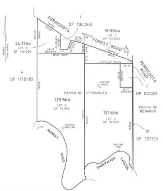
Figure 2: Proposed
subdivision plan
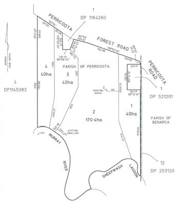
Statutory Assessment Process
2.1 Environmental
Planning and Assessment Act 1979
Section
1.3 Objects
Comment: It is considered that the proposed
development is not inconsistent with the objects of the Act, subject to
appropriate conditions of consent being imposed.
Section 1.7 Application of Part 7 of Biodiversity
Conservation Act 2016 and Part 7A of Fisheries Management Act 1994
Comment: It is considered that the proposed
development will not have a significant effect on the terrestrial and aquatic
environment, threatened species, populations or ecological communities, or
their habitats. The proposal is not considered to create any significant
adverse environmental impact. It is therefore considered that the proposal is
not inconsistent with Part 7 of the Biodiversity Conservation Act 2016
and Part 7A of the Fisheries Management Act 1994.
Section 4.14 Consultation and development
consent—certain bush fire prone land
Comment: The site is mapped as Bush Fire Prone
Land. The application was referred to NSW RFS with no formal response received
as of 10 March 2020.
Section 4.15 Evaluation
Comment: This report provides the necessary review and
evaluation of the development application. See below.
Section 4.46 What is “integrated
development”?
Comment: It is considered that the proposal is not
classed as Integrated Development with NSW RFS as the proposal seeks to create
allotments within the RU1 Primary Production zone with restrictive covenants
imposed on the lots outlining residential accommodation, and tourist and
visitor accommodation, is prohibited from occurring on the land.
2.2 Contributions
Section 7.11 (formerly Section 94) Development Contributions
are not required.
Section 7.12 (formerly Section 94A) Levy Development
Contributions are not required.
Section 64 contributions are not required.
Town Planning Assessment
Assessment of the development application has been
undertaken in respect to relevant considerations arising from Section 4.15 of
the Environmental Planning and Assessment Act 1979 as follows:
3.1 Section 4.15 Evaluation
(1) Matters for
consideration-general
In
determining a development application, a consent authority is to take into
consideration such of the following matters as are of relevance to the
development the subject of the development application:
(a) the
provisions of:
(i) any
environmental planning instrument, and
(ii) any
proposed instrument that is or has been the subject of public consultation
under this Act and that has been notified to the consent authority (unless the
Planning Secretary has notified the consent authority that the making of the
proposed instrument has been deferred indefinitely or has not been approved),
and
(iii) any
development control plan, and
(iiia) any
planning agreement that has been entered into under section 7.4, or any draft
planning agreement that a developer has offered to enter into under section
7.4, and
(iv) the
regulations (to the extent that they prescribe matters for the purposes of this
paragraph), and
(v) (Repealed)
that apply to the land to
which the development application relates,
(b) the
likely impacts of that development, including environmental impacts on both the
natural and built environments, and social and economic impacts in the
locality,
(c) the
suitability of the site for the development,
(d) any
submissions made in accordance with this Act or the regulations,
(e) the
public interest.
Matters for
consideration
3.2(a) the provisions
3.2(a)(i) Environmental Planning
Instruments
3.2(a)(i)a Murray Local Environmental Plan
2011 (Available http://www.legislation.nsw.gov.au/#/view/EPI/2011/682)
Part 1 Preliminary
Clause 1.2 Aims of Plan
Comment: The proposed development is not specifically
inconsistent with the aims of Murray LEP 2011. The application will be
appropriately conditioned to ensure compliance with the aim to ‘identify,
protect, conserve and enhance Murray’s natural assets’, due to the
submitted plans being inconsistent with Clause 7.4 of the Murray LEP 2011.
Clause 1.9A Suspension
of covenants, agreements and instruments
Comment: For the purpose of enabling development on land in any zone
to be carried out in accordance with this Plan or with a consent granted under
the Act, any agreement, covenant or other similar instrument that restricts the
carrying out of that development does not apply to the extent necessary to
serve that purpose.
Part 2 Permitted or
prohibited development
Clause 2.3 Zone objectives and Land Use Table
(development permissibility)
Zone: RU1 Primary Production
§ To encourage
sustainable primary industry production by maintaining and enhancing the
natural resource base.
§ To encourage
diversity in primary industry enterprises and systems appropriate for the area.
§ To minimise the
fragmentation and alienation of resource lands.
§ To minimise
conflict between land uses within this zone and land uses within adjoining
zones.
Comment: It is considered that the proposed
development is not inconsistent with the objectives of the RU1 Primary
Production zone of the Murray LEP 2011.
Clause 2.6
Subdivision—consent requirements
Comment: Noted. Consent has been applied for.
Part 3 Exempt and complying
development
Comment: Not applicable.
Part 4 Principal development standards
Clause 4.1 Minimum subdivision lot size
Comment: Not applicable. Clause 4.2 ‘Rural
Subdivision’ to be used in this instance.
Clause 4.2 Rural Subdivision
(1) The objective of this clause is to provide
flexibility in the application of standards for subdivision in rural zones to
allow land owners a greater chance to achieve the objectives for development in
the relevant zone.
Comment: The applicant has proposed to utilise this
clause to facilitate the proposed development.
(2) This clause applies to the following rural
zones—
(a) Zone RU1 Primary Production,
(b) Zone RU2 Rural Landscape,
(baa) Zone RU3 Forestry,
(c) Zone RU4 Primary Production Small Lots,
(d) Zone RU6 Transition.
Note.
When this Plan was made, it did not include Zone RU2
Rural Landscape, Zone RU4 Primary Production Small Lots or Zone RU6 Transition.
Comment: This clause is applicable.
(3) Land in a zone to which this clause applies may,
with development consent, be subdivided for the purpose of primary production
to create a lot of a size that is less than the minimum size shown on the Lot Size Map in relation to that land.
Comment: Three of the proposed allotments are below
the minimum lot size provisions affecting the site. The applicant however has
stated that the proposed subdivision is for the purposes of primary production,
therefore this clause can be utilised.
(4) However, such a lot cannot be created if an
existing dwelling would, as the result of the subdivision, be situated on the
lot.
Comment: An existing dwelling is located on proposed
lot 2, however this lot is above the minimum lot size requirements affecting
the land, therefore is not inconsistent.
(5) A dwelling cannot be erected on such a lot.
Note.
A dwelling includes a rural worker’s dwelling
(see definition of that term in the Dictionary).
Comment: Any consent issued will be appropriately
conditioned to ensure compliance with this requirement.
Clause 4.2C Exceptions to minimum lot sizes for certain
rural subdivisions
Comment: Not applicable. Clause 4.2 has been
utilised.
Clause 4.2D Boundary adjustments in Zones RU1 and E3
Comment: Not applicable. Clause 4.2 has been
utilised.
Clause 4.6 Exceptions to development standards
Comment: Not applicable.
Part 5 Miscellaneous provisions
Clause 5.10 Heritage conservation
Comment: The site does not contain any known items of
Environmental Heritage Significance. It is the responsibility of the Applicant
to ensure compliance with the Due Diligence Code of Practice for the
Protection of Aboriginal Objects in New South Wales. Any consent issued
will contain the standard OEH condition regarding protection of Aboriginal
Cultural Heritage.
Clause 5.10 Subdivision of, or dwellings on, land in
certain rural, residential or environment protection zones
Comment: This clause is not applicable as the
proposal subdivision is not for the purposes of a dwelling.
Part 6 Urban release areas
Comment: Not applicable. The subject site is not
mapped as an Urban Release Area.
Part 7 Additional local provisions
Clause 7.1 Essential services
Development consent must not be granted to development
unless the consent authority is satisfied that any of the following services
that are essential for the proposed development are available or that adequate
arrangements have been made to make them available when required:
|
Subclause
|
Comment
|
|
(a) the supply of water,
|
The applicant has stated the supply of
water will be via treated water from tanks and raw water from the Murray
River.
|
|
(b) the supply of
electricity,
|
The existing dwelling is connected to
electricity.
|
|
(c) the disposal and
management of sewage,
|
The existing dwelling is connected to a
septic tank.
|
|
(d) stormwater drainage or
on-site conservation,
|
No additional stormwater is to be created.
|
|
(e) suitable road access
|
Access to the proposed lots available from Perricoota
Forest Road. Existing access to the property.
|
Clause 7.2 Earthworks
Comment: No earthworks are proposed.
Clause 7.3 Biodiversity protection
Comment: Part of the subject site is covered by
Council’s biodiversity mapping. The proposed development was referred to
the Biodiversity and Conservation Division of the Department of Planning,
Industry and Environment and no objections were raised. Given the nature of the
development it can be concluded that the proposed subdivision of the land would
be unlikely to have any adverse impact on the condition, ecological value and
significance of the fauna and flora on the land. Existing habitat elements on
site will not be detrimentally affected by the proposed development.
Clause 7.4 Development on river front areas
(1) The objectives of this clause are as
follows—
(a) to support natural riverine processes,
including the migration of the Murray and Wakool Rivers’ channels,
(b) to protect and improve the bed and bank
stability of those rivers,
(c) to maintain and improve the water quality of
those rivers,
(d) to protect the amenity, scenic landscape
values and cultural heritage of those rivers and to protect public access to
their riverine corridors,
(e) to conserve and protect the riverine
corridors of those rivers, including wildlife habitat.
Comment: The subject land contains land classed as a
river front area. It is considered that the proposal is not inconsistent with
the objectives of the clause subject to an appropriate condition being placed
on any consent issued prohibiting subdivision of the river front area.
(2) Despite any other provision of this Plan,
development consent may only be granted to development on land in a river front
area for the following purposes—
(a) boat building and repair facilities, boat
launching ramps, boat sheds, charter and tourism boating facilities or marinas,
(b) the extension or alteration of an existing
building that is wholly or partly in the river front area, but only if the
extension or alteration is to be located no closer to the river bank than the
existing building,
(c) environmental protection works,
(d) extensive agriculture and intensive plant
agriculture,
(e) environmental facilities and recreation
areas,
(f) water recreation structures.
Comment: The proposal as submitted is prohibited
under the terms of Clause 7.4 of the MLEP as it relates to a type of
development (i.e. “subdivision”) that is not specifically provided
for under cl.7.4(2). It is noted however that any consent issued will include an
appropriate condition of consent requiring an amendment to the design to avoid
subdivision of the river front area portion of the subject site. This is to
also comply with the comments received from NSW Department of Planning,
Industry and Environment.
(3) Development consent must not be granted under
subclause (2) unless the consent authority is satisfied of the following—
(a) that the appearance of the development, from
both the river concerned and the river front area, will be compatible with the
surrounding area,
(b) that the development is not likely to cause
environmental harm, including (but not limited to) the following—
(i) pollution or siltation of the river
concerned,
(ii) any adverse effect on surrounding uses,
riverine habitat, wetland areas or flora or fauna habitats,
(iii) any adverse effect on drainage patterns,
(c) that the development is likely to cause only
minimal visual disturbance to the existing landscape,
(d) that continuous public access, and
opportunities to provide continuous public access, along the river front and to
the river concerned are not likely to be compromised,
(e) that any historic, scientific, cultural,
social archaeological, architectural, natural or aesthetic significance of the land on which the development is to be
carried out and of surrounding land is to be maintained.
Comment: The application is not inconsistent with the
requirements of this subclause subject to appropriate conditions being placed
on any consent issued.
Clause 7.5 Riparian land and Murray River and other
watercourses—general principles
Comment: The proposal relates to riparian land
including land along the bank of the Murray River as well as land within 40
metres of the top of the bank of a watercourse. However as there are no works proposed
it is concluded that the development outcome will be consistent with relevant
Clause objectives including protecting and maintaining the stability of the bed
and banks of watercourses.
Further the proposed development will not adversely affect
water quality, riparian vegetation, the passage of fish.
Clause 7.6 Additional
provisions—development on river bed and banks of the Murray and Wakool Rivers
Comment: Not applicable.
Clause 7.7 Wetlands
Comment: Part of the subject site is mapped as
wetlands. Any consent issued will be appropriately conditioned to ensure the
protection of the wetlands area, in accordance with the requirements of NSW
Department of Planning, Industry and Environment.
Clause 7.8 Flood planning
Comment: Part of the subject site is mapped as flood
prone land. As no physical development is proposed, and any consent issued will
include conditions prohibiting residential and tourist type development on
site, it is considered the proposal is not inconsistent with the requirements
of the clause.
3.2(a)(i)b Murray Regional Environmental Plan No. 2—Riverine Land
Comment: The subject site is mapped as Murray
Regional Environmental Plan 2 – Riverine Land.
Part 1 Introduction
Clause 2 Aims of the plan
Comment: It is considered the proposal is not
inconsistent with the requirements of the clause, subject to appropriate
conditions being place on any consent issued.
Clause 3 Objectives of the plan
Comment: It is considered the proposal is not inconsistent
with the requirements of the clause, subject to appropriate conditions being
place on any consent issued.
Part 2 Planning principles
Clause 9 General principles
Comment: It is considered that the application is not
specifically inconsistent with the general principles.
Clause 10 Specific principles
Comment: It is considered that the application is not
specifically inconsistent with the specific principles.
Part 3 Planning requirements and consultation
Clause 13 Planning
Control and Consultation Table
Comment: The Application was referred in accordance
with the requirements of wetlands subdivision.
Clause 14 Building setbacks—special
provisions
Comment: Noted. No building works proposed.
3.2(a)(i)c State Environmental
Planning Policy No 21—Caravan Parks
Comment: Not applicable.
3.2(a)(i)d State Environmental
Planning Policy No 33—Hazardous and Offensive Development
Comment: Not applicable.
3.2(a)(i)e State Environmental
Planning Policy No 36—Manufactured Home Estates
Comment: Not applicable.
3.2(a)(i)f State Environmental
Planning Policy No 44—Koala Habitat Protection
Comment: The subject land is not considered to be
core koala habitat or potential core koala habitat.
3.2(a)(i)g State Environmental
Planning Policy No 55—Remediation of Land
Comment: The subject land is not considered to be
contaminated or likely to be contaminated and is not listed on Council’s
Contaminated Land Register. In accordance with Clause 7 of SEPP 55, Council is
satisfied that, the land is suitable in its current state for the purpose for
which the development is proposed to be carried out.
3.2(a)(i)h State Environmental
Planning Policy No 64—Advertising and Signage
Comment: Not applicable.
3.2(a)(i)i State Environmental
Planning Policy No 65—Design Quality of Residential Apartment Development
Comment: Not applicable.
3.2(a)(i)j State Environmental
Planning Policy No 70—Affordable Housing (Revised Schemes)
Comment: Not applicable.
3.2(a)(i)k State Environmental
Planning Policy (Affordable Rental Housing) 2009
Comment: Not applicable.
3.2(a)(i)l State Environmental
Planning Policy (Building Sustainability Index: BASIX) 2004
Comment: Not required.
3.2(a)(i)m State Environmental
Planning Policy (Concurrences) 2018
Comment: Not applicable.
3.2(a)(i)n State Environmental
Planning Policy (Educational Establishments and Child Care Facilities) 2017
Comment: Not applicable.
3.2(a)(i)o State Environmental
Planning Policy (Exempt and Complying Development Codes) 2008
Comment: The proposed development cannot be classed
as exempt or complying development as it does not meet all of the development
requirements.
3.2(a)(i)p State Environmental
Planning Policy (Housing for Seniors or People with a Disability) 2004
Comment: Not applicable.
3.2(a)(i)p State Environmental
Planning Policy (Infrastructure) 2007
Comment: Not applicable.
3.2(a)(i)q State Environmental
Planning Policy (Mining, Petroleum Production and Extractive Industries) 2007
Comment: Not applicable.
3.2(a)(i)r State Environmental
Planning Policy (Miscellaneous Consent Provisions) 2007
Comment: Not applicable.
3.2(a)(i)s State Environmental
Planning Policy (Primary Production and Rural Development) 2019
Comment: The proposed
development is not inconsistent with this Policy.
3.2(a)(i)t State Environmental Planning
Policy (State and Regional Development) 2011
Comment: Not applicable.
3.2(a)(i)u State Environmental
Planning Policy (State Significant Precincts) 2005
Comment: Not applicable.
3.2(a)(i)v State Environmental
Planning Policy (Vegetation in Non-Rural Areas) 2017
Comment: Not applicable.
3.2(a)(ii) Proposed instruments
Comment: Draft Murray LEP 2011 applies, however does
not specifically affect the subject site.
3.2(a)(iii) Any development control plan
Comment: Murray
Development Control Plan 2012 to the proposal.
Chapter 7 Subdivision
Comment: The proposal is
not inconsistent with the requirements of this chapter. The majority of the
controls outlined in this chapter relate to residential subdivisions and
therefore are not applicable.
Chapter 9 Vegetation Removal
Comment: No vegetation is
proposed to be removed.
Chapter 10 Watercourses &
Riparian Land
Comment: Noted.
Chapter 11 Flood Prone Land
Comment: The
subject land is mapped as Flood Prone Land. It is noted that no issues in
respect of flooding were raised as a consequence of MREP2 referral of the
proposal. It is also noted that the application does not propose the
construction of any structures. It is therefore considered that the proposal is
unlikely to impact upon the existing flow of flood water on that land or
adjoining land.
Chapter 12 Notification Policy
Comment: The application
was notified to adjoining property owners in accordance with this Chapter.
3.2(a)(iiia)
Any Planning Agreements
Comment: No planning agreements apply.
3.2(a)(iv)
The regulations
Comment:
The regulations have been considered in the assessment of this application. It
is considered that the application is not inconsistent with the objectives of
the regulations.
3.3(b) the
likely impacts of that development, including environmental impacts on both the
natural and built environments, and social and economic impacts in the
locality.
Environmental
Impacts
Natural
Environment
The proposed
development will be appropriately conditions to ensure the natural environment
is not adversely impacted upon.
Built
Environment
The proposed
development is unlikely to adversely impact upon the built environment.
Social
Impacts
The proposed development
is unlikely to create any adverse social impact.
Economic
Impacts
The proposed
development is unlikely to create any adverse economic impact.
· Traffic and Parking: No issues
identified.
· Noise: It is considered that the
proposed development will not produce any significant adverse noise impacts.
· Amenity: The proposal is unlikely to
have an adverse impact on the amenity of the immediate locality.
· Waste: Not applicable.
· Non-Aboriginal Heritage: Not applicable.
The site is not subject to any heritage conservation provisions.
· Aboriginal Cultural Heritage: No known
items identified on the subject land. In any event statutory requirements would
trigger contingency measures if any cultural heritage was subsequently
identified.
· Bushfire Hazard: The subject land is
located within an area identified as being bushfire prone. NSW RFS did not
object to the granting of consent.
· Water Quality & Stormwater:
Satisfactory.
· Soils, soil erosion: Satisfactory.
· Flora & Fauna: Satisfactory. No
areas of critical habitat are affected by the proposal. No native vegetation on
site will be impacted upon.
· Utilities: Satisfactory.
· Signage: Not applicable
· Safety, security & crime prevention:
Not applicable.
3.4(c) The
suitability of the site for the development
Comment: Subject to
appropriate conditions of consent (prohibiting subdivision of river front area
land), the subject site is considered suitable for the
proposed development.
3.5(d) any
submissions made in accordance with this Act or the regulations,
|
Agency
|
Response
|
|
NSW Rural Fire Service
|
No formal
response received.
|
|
Dept. of Industries (Crown Lands)
|
No
Objections. No conditions were imposed.
|
|
NSW Department of Planning, Industry and Environment -
Biodiversity and Conservation Division
|
No Objections
subject to conditions.
|
|
Murray Darling Basin Authority
|
No
Objections. No conditions were imposed.
|
|
NSW Environment Protection Authority
|
No
Objections. No conditions were imposed.
|
|
NSW Dept. of Primary Industries (Fisheries)
|
No
Objections. Comments received.
|
|
Shire of Campaspe
|
No
Objections. No conditions were imposed.
|
|
NSW Department of Planning & Environment –
Planning Division
|
Comments
received which included that ‘Council must consider and impose
relevant conditions that relate to subdivision design, the retention or
planting of a vegetated buffer and fencing to exclude stock or vermin as
prescribed by the MREP2’. Any consent will therefore be
appropriately conditioned.
|
|
Natural Resources Access Regulator
|
No
Objections. No conditions were imposed..
|
|
WaterNSW
|
No
objections.
|
|
Victorian Department of Planning, Environment, Land and
Water
|
No response
received.
|
|
Department of Primary Industries - Agriculture
|
Comments
received. See below:
“The
NSW Department of Primary Industries Agriculture provides advice to consent
authorities about the protection and growth of agricultural industries and
the resources upon which these industries depend to provide economic growth.
The Department
supports Council position that dwelling entitlements are prohibited on the
proposed Lots as the land does not meet the minimum lot size criteria.
Although
the proposal asserts there will be no significant impacts on the area’s
agricultural resources, DPI Agriculture, in principle, does not agree with
further fragmentation of Lots in the Rural Zone”.
|
Public
Submissions
A number of
public submissions were received. The submissions all objected to the
application. In summary matters raised include:
- Similar application has recently already been refused.
- Non-compliance
with minimum lot size provisions.
- The
application is not related to agriculture but rather preparing a property with
river frontage for sale.
- The
proposal will lead to added pressure for housing on the new 40ha vacant lots.
- Access
issues including a lack of all-weather access to each lot.
- Concerns
regarding flooding.
- Impact
to natural environment
- Existing
problems associated with land management including weed control will be
exacerbated.
The issues raised by the
objectors have been duly considered and taken into consideration as part of the
assessment. It is considered that subject to appropriate conditions being
placed on any consent, the application is unlikely to adversely impact upon the
locality and can be approved.
3.6(e) The
public interest.
The public interest is served through the
detailed assessment of this application under the Environmental Planning and
Assessment Act 1979, the Environmental Planning and Assessment Regulation 2000,
Environmental Planning Instruments, Development Control Plan and policies. It
is considered that the proposal is not inconsistent with the public interest
subject to conditions being placed on any consent issued.
Conclusion
The proposed
development has been assessed in accordance with the provisions of Section 4.15
of the Environmental Planning and Assessment Act 1979 and is considered
to be satisfactory subject to appropriate conditions being included with any
consent issued. This is to ensure the proposed development is consistent with
the requirements of Clause 7.4 ‘Development on River Front Areas’
of the Murray LEP 2011. It is therefore recommended that development consent be granted subject to appropriate conditions listed below.
Conditions:
A. Conditions Prescribed by the Environmental
Planning & Assessment Regulation 2000
Clause 98:
Compliance with Building Code of Australia and insurance requirements under the
Home Building Act 1989
Clause 98A:
Erection of signs
Clause 98B:
Notification of Home Building Act 1989 requirements
Clause 98C:
Conditions relating to entertainment venues
Clause 98D:
Conditions relating to maximum capacity signage
Clause 98E:
Conditions relating to shoring and adequacy of adjoining property
Please refer
to the NSW State legislation for full text of the clauses under Division 8A of
the Environmental Planning and Assessment Regulation 2000. This can be accessed
at http://www.legislation.nsw.gov.au.
B. Planning conditions
PURSUANT TO
SECTION 4.16(3) OF THE ENVIRONMENTAL PLANNING AND ASSESSMENT ACT 1979 THIS IS A
‘DEFERRED COMMENCEMENT’ CONSENT SUBJECT TO COMPLIANCE WITH THE
FOLLOWING CONDITIONS OF CONSENT
D1. River Front Area
An amended subdivision plan must be
submitted to and approved by Council, which adheres to Clause 7.4 of Murray
Local Environmental Plan 2011 (i.e. the land within 100m of the main channel of
the Murray River must be contained within one allotment to avoid subdivision of
river front area which is prohibited development). The submitted plan must be
to the satisfaction of Council.
Reason: To ensure the development complies with Clause
7.4 of the Murray LEP 2011 and to comply with the requirements of NSW Department
of Planning, Industry and Environment.
D2. Re-vegetation Plan
A
Re-vegetation Plan must be prepared, submitted to and approved by Council. This
plan must be prepared by a suitably qualified person to the satisfaction of
Council. The submitted plan must detail
the use of locally native species, including a range of plant life forms
including trees and shrubs.
The plan must outline
re-vegetation of the river front area land which abuts proposed Lots 3 and 4 of
the submitted plan.
Once
approved, the proponent is responsible for the funding and completion of
required planting in accordance with the approved plan. Re-vegetation planting
must be completed in accordance with the approved plan prior to the release of
the Subdivision Certificate.
Note:
Under the Murray LEP 2011;
river front area means—
(a) in
Zone RU5 Village, Zone R1 General Residential, Zone R2 Low Density Residential,
Zone R5 Large Lot Residential, Zone SP3 Tourism and Zone B2 Local
Centre—the land within 40m of the top of the bank of the Murray or Wakool
River, or
(b) in
Zone RU1 Primary Production, Zone RU3 Forestry and Zone E3 Environmental
Management—the land within 100m of the top of the bank of the Murray or
Wakool River.
Reason: To ensure the development complies with Murray REP2
and to comply with NSW DPIE recommendations.
General Conditions
that must be fulfilled
1. Approved plans
The
subdivision must be carried out in accordance with the plan as approved by the
above Deferred Commencement Condition except where Council has been
notified and consented to any amendments.
All conditions of consent must be fulfilled to the standard of
Council and at the expense of the proponent.
Reason: To ensure that the development is carried out as
assessed.
2. Engineering Guidelines for Subdivisions and Development Standards
The
proponent must comply with
Council’s Engineering Guidelines for Subdivisions and Development Standards in conjunction with the advice from
Council’s Engineering Department.
Reason: To ensure that the subdivision is carried out in
accordance with Council’s Subdivision Development Requirements.
3. Water supply work, sewerage work and stormwater
drainage work
Water supply work or sewerage work that is
plumbing and drainage work within the meaning of the Plumbing and Drainage
Act 2011 must comply with that Act and the regulations under that Act. Any
water supply work or sewerage work that is not plumbing and drainage work under
that Act, and any stormwater drainage work, must comply with the Plumbing Code
of Australia.
Reason: Council and
Statutory requirement of Local Government (General) Regulation 2005.
4. Protection of native vegetation
There
must be no clearing of native vegetation (including within Council’s road
reserve).
Reason: To comply
with the Biodiversity Conservation Act 2016.
5. Aboriginal Cultural Heritage
If any Aboriginal object is
discovered and/or harmed in, or under the land, while undertaking the proposed
development activities, the proponent must:
o Not further
harm the object;
o Immediately
cease all work at the particular location;
o Secure
the area so as to avoid further harm to the Aboriginal object;
o Notify
NSW Department of Planning, Industry and Environment - Biodiversity and
Conservation Division as soon as practical on 131 555, providing any details of
the Aboriginal object and its location; and
o Not
recommence any work at the particular location unless authorised in writing by
NSW Department of Planning, Industry and Environment - Biodiversity and
Conservation Division.
In the event that skeletal remains
are unexpectedly encountered during the activity, work must stop immediately,
the area secured to prevent unauthorised access and NSW Police and NSW
Department of Planning, Industry and Environment - Biodiversity and
Conservation Division contacted.
All reasonable precautions must be
taken to prevent damage to Aboriginal objects.
For more information please refer
to the NSW Department of Environment, Climate Change and Water (NSW Department
of Planning, Industry and Environment - Biodiversity and Conservation Division)
document entitled: Due diligence Code of Practice for the Protection of
Aboriginal Objects in New South Wales, available: http://www.environment.nsw.gov.au/resources/cultureheritage/ddcop/10798ddcop.pdf.
Reason: To
protect Aboriginal heritage.
6. No
pollution of waterways
The proponent must take all
necessary precautions and implement measures to prevent pollution of waterways
during the proposed works.
Reason: To accord with the requirements of NSW
Environmental Protection Authority.
7. Government Authorities
The proponent must comply with
all conditions and requirements outlined in any NSW Rural Fire Services,
Murray-Darling Basin Authority, or Natural Resources Access Regulator
correspondence received after 10 March 2020 and before the application is
determined by Council.
Reason: To ensure Government authorities conditions of
consent are included with this consent.
Conditions
that must be fulfilled prior to the release of the Subdivision Certificate
8. Subdivision Certificate Application
The
submission of formal subdivision plans (with layout as required by Condition
D1.) and an application for Subdivision Certificate including the applicable
fees must be made with Council. The fee will be charged in accordance
with the fee schedule applicable at the time the application for Subdivision
Certificate is lodged with Council. Easements
must be shown over all services and covenants as required by the
conditions of consent incorporated into the appropriate instruments. Four (4) copies of the formal subdivision
plans, Administration Sheet and 88B Instrument Sheet must be provided to Council. All four (4) copies of the
Administration Sheet and 88B Instrument Sheet must
contain original signatures. Executed copies will not be
accepted. A completed copy of Council’s checklist outlining all
conditions have been met must be submitted with the application for a
Subdivision Certificate. The Subdivision Certificate is not released prior to
all applicable conditions of consent for this development being complied with
to the satisfaction of Council.
Reason: To comply with the Environmental Planning and
Assessment Act 1979.
9. Water
Supply Easement
A water supply easement from the
Murray River to proposed lots 3 and 4 must be
registered. The easement must be a maximum of 1m in width and for water supply
purposes only. This must be shown on
the formal subdivision plans prior to the
release of the Subdivision Certificate.
Reason: To ensure the allotments created for primary
production purposes have access to water supply.
10. Rural Address Numbers
An individual Rural Address Number (RAN)
must be assigned to each allotment. The fee required for the sign, post &
installation for any new RAN required will be charged in accordance with the
fee schedule applicable at the time the application for Subdivision Certificate
is lodged and payable to Council prior to the issue of a Subdivision
Certificate. Please contact Council’s Engineering Department for more
detail.
Reason: To ensure the lots are able to be identified.
11. Vegetation buffer
Revegetation
works and buffer plantings must be completed to the satisfaction of Council in
accordance with the approved plan. A rural style fence must also be constructed
along the length of the vegetated buffer to exclude stock.
Reason: To ensure the development complies with Murray
Regional Environmental Plan No 2 – Riverine Land.
12. Restrictive Covenant
The Applicant must submit a copy
of an instrument prepared in accordance with the Conveyancing Act 1919,
with the application for a Subdivision Certificate for Council’s
endorsement. The instrument must contain the following:
· A restrictive
covenant on Proposed Lots 1, 3 and 4 outlining that the land may only be used
for extensive agriculture purposes.
· The covenant must
also specifically state that any form of residential accommodation (including
but not limited to dwelling houses, dwellings, rural workers’ dwellings,
manufactured homes, moveable dwellings, relocatable dwellings), and any form of
tourist and visitor accommodation or caravan parks/camping grounds, is
prohibited on site. The restrictive covenant must benefit Murray River Council,
and the wording of the Restrictive Covenant must be to the satisfaction of
Council.
Note: Under the Murray Local
Environmental Plan 2011:
extensive agriculture means any of the following—
(a) the
production of crops or fodder (including irrigated pasture and fodder crops)
for commercial purposes,
(b) the
grazing of livestock (other than pigs and poultry) for commercial purposes on
living grasses and other plants on the land as their primary source of dietary
requirements, and any supplementary or emergency feeding, or temporary
agistment or housing for weaning, dipping, tagging or similar husbandry purposes,
of the livestock,
(c) bee
keeping,
(d) a
dairy (pasture-based) where the animals generally feed by grazing on living
grasses and other plants on the land as their primary source of dietary
requirements, and any supplementary or emergency feeding, or temporary
agistment or housing for weaning, dipping, tagging or similar husbandry
purposes, of the animals.
residential accommodation means a building or place used predominantly as a
place of residence, and includes any of the following—
(a) attached
dwellings,
(b) boarding
houses,
(c) dual
occupancies,
(d) dwelling
houses,
(e) group
homes,
(f) hostels,
(g) multi
dwelling housing,
(h) residential
flat buildings,
(i) rural
workers’ dwellings,
(j) secondary
dwellings,
(k) semi-detached
dwellings,
(l) seniors
housing,
(m) shop
top housing,
but does not include tourist and visitor accommodation or
caravan parks.
tourist and visitor
accommodation means a
building or place that provides temporary or short-term accommodation on a
commercial basis, and includes any of the following—
(a) backpackers’
accommodation,
(b) bed
and breakfast accommodation,
(c) farm
stay accommodation,
(d) hotel
or motel accommodation,
(e) serviced
apartments,
but does not include—
(f) camping
grounds, or
(g) caravan
parks, or
(h) eco-tourist
facilities.
Reason: To ensure that a copy
of a Restrictive Covenant is provided to Council for review and endorsement in
order to ensure compliance with Clause 4.2 ‘Rural Subdivision’ of
the Murray Local Environmental Plan 2011 and that the development proceeds as
per submitted.
13. Primary production use
Prior to the release of the
Subdivision Certificate, the Proponent must provide evidence to the
satisfaction of Council that Proposed Lots 1, 3 and 4 have been established
with extensive agriculture practices as outlined in the submitted application.
It is noted there must be no
clearing of native vegetation in order to accommodate agricultural activities
other than that approved by NSW Murray Local Land Services or in accordance
with the provisions of the Biodiversity Conservation Act 2016.
Reason: To suitably
satisfy Council that the agricultural basis for subdivision consent has been
commenced.
14. Access
Prior to the issue of the
Subdivision Certificate a formed driveway access to Council specifications must be provided to each allotment. A
separate application must be made to
Council’s Engineering Department for approval to construct any driveway
access.
Reason: To protect
Council assets and to ensure compliance with the Roads Act 1993 which
requires the road authority to give permission for an activity within the road
reserve.
Advice to
applicant
The land subject to this
consent may have restrictive covenants applying to it. It is the responsibility
of the owner and builder to ensure that covenants are adhered to. Council does
not enforce or regulate covenants and therefore accepts no responsibility for
checking the compliance of building design with such covenants.
Reason: To advise of the details of Clause 1.9A of the
Murray LEP 2011.
It is noted that it is the responsibility of the Applicant
to ensure that the development is consistent with the NSW Department of
Environment, Climate Change and Water (NSW OEH) document entitled: Due
Diligence Code of Practice for the Protection of Aboriginal Objects in New
South Wales, available: http://www.environment.nsw.gov.au/resources/cultureheritage/ddcop/10798ddcop.pdf.
Reason: To ensure compliance with the Due Diligence
Code of Practice for the Protection of Aboriginal Objects.
Underground assets may exist in the area that is subject to
the application. In the interests of health and safety and in order to protect
damage to third party assets please contact Dial Before You Dig at www.1100.com.au
or telephone on 1100 before excavating or erecting structures. If alterations
are required to the configuration, size, form or design of the development upon
contacting the Dial Before You Dig service, an amendment to the development
consent (or a new development application) may be necessary.
Individuals owe asset owners a duty of care that must be
observed when working in the vicinity of plant or assets on the relevant
property via contacting the Dial Before You Dig service in advance of any
construction or planning activities.
Reason: To protect
underground assets.
It is the
responsibility of the applicant to check, understand and seek assistance where
needed so as to ensure full compliance with the conditions of this Development
Consent. Please contact Murray River Council on 1300 087 004 or admin@murrayriver.nsw.gov.au if there
is any difficulty in understanding or complying with any of the above
conditions
Reason: To ensure the Applicant is aware of their
obligations.
The development must be in accordance with the relevant
provisions and Regulations of the Biodiversity Conservation Act 2016,
the Fisheries Management Act 1994, the National Parks and Wildlife
Act 1974, the Protection of the Environment Operations Act 1997, and
all other applicable legislation.
Reason: To comply with relevant legislation.
The proponent should be
aware that under Section 120 of the Protection of the Environment Operations
Act 1997 it is an offence to pollute waters.
Reason: To comply with
NSW EPA requirements.
It is the Applicant’s responsibility
to ensure compliance with the requirements of the Disability Discrimination
Act 1992 (DDA). Note: Compliance with the Building Code of Australia
does not necessarily meet the requirements of the DDA. You are advised to
seek advice from the Australian Human Rights and Equal Opportunity Commission
(phone (02) 9284 9600) in respect of your application.
Reason: To comply
with the Disability Discrimination Act
1992.
The landowner should be aware, that any
extraction and use of water from the Murray River, must be done so in
accordance with the Water Management Act 2000.
Reason: To advise of
WaterNSW requirements.
The proponent needs to be aware that the MDBA has responsibility
to regulate the River Murray and cannot guarantee water levels. As part of
river operations, variation in river and weir pool levels, both up and
downstream, may become more pronounced, and average levels may significantly
change.
Reason: To advise of
MDBA requirements.
Attachments
1. Public
Submission 1 ⇩ 
2. Public
Submission 2 ⇩ 
3. Public
Submission 1 - Video Link ⇩ 
4. Public
Submission 2 - Video Link ⇩
|
MURRAY RIVER
COUNCIL Ordinary Council Meeting Agenda
|
26 May 2020
|
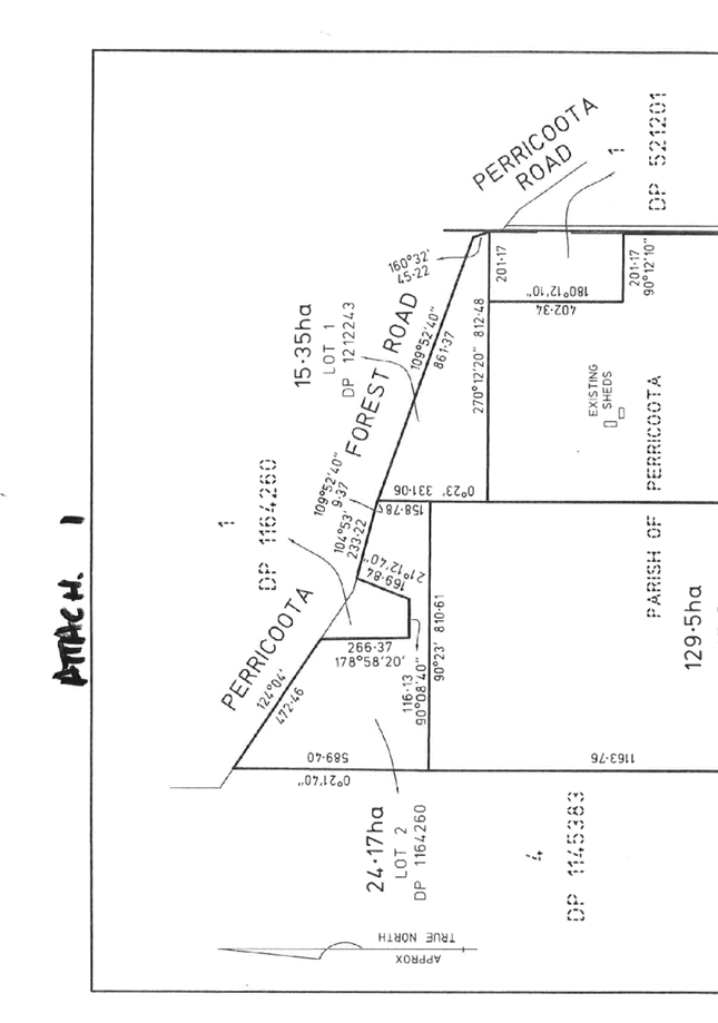
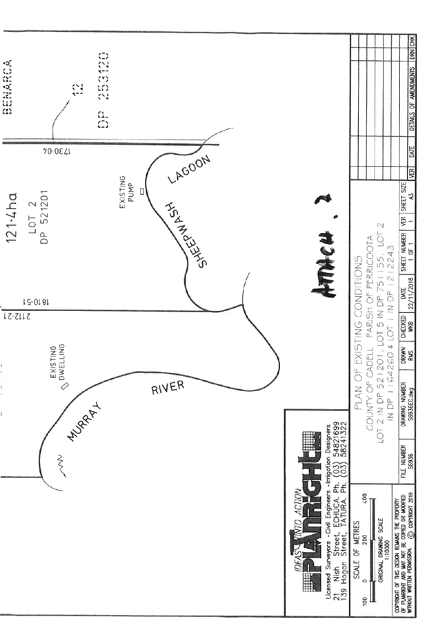
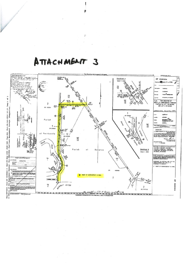
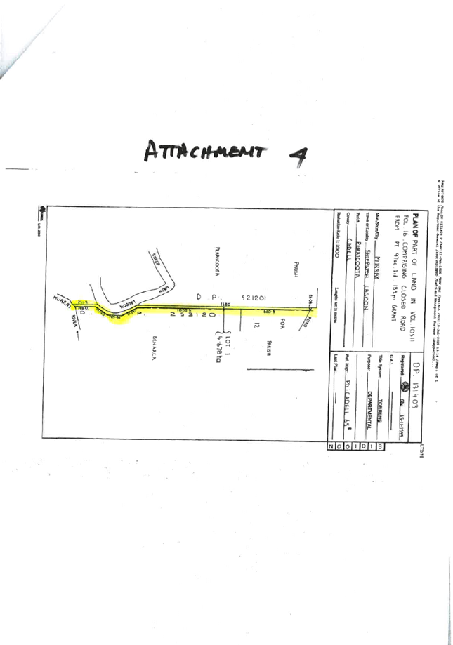
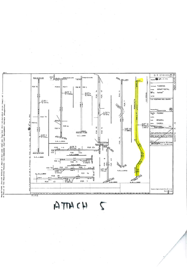
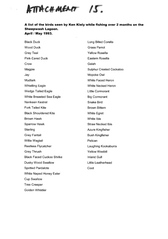
|
MURRAY RIVER COUNCIL Ordinary
Council Meeting Agenda
|
26 May 2020
|
|
MURRAY RIVER COUNCIL Ordinary
Council Meeting Agenda
|
26 May 2020
|

|
MURRAY RIVER
COUNCIL Ordinary Council Meeting Agenda
|
26 May 2020
|

8.4.5 Development Application
10.2013.115.2 (DA 115/13 Amendment One) - Construction of Dwelling House
File
Number: -
Author: Christopher
O'Brien, Senior Town Planner
Authoriser: David
Wilkinson, Director Planning, Waste & Regulatory Services
Applicant: Planright
Surveying
Owner: Genevieve
Susan Canfield
Proposal: Amendment
One: Construction of Dwelling House
Details of Amendment One: Amendment of structure from manufactured home to a
building (dwelling house), and reduction of setback from bank of Murray River
from 100m to 80m
Location: Lot
1, DP851678, 3 Forbes Street, Moama
|
Recommendation
That Development
Application 10.2013.115.2 (DA 115/13 Amendment One) for the construction of a
dwelling house on Lot 1, DP851678, 3 Forbes Street, Moama, be refused
modified development consent, due to the following reasons:
1. The application is
inconsistent with Clause 7.4 ‘Development on river front areas’ of
the Murray Local Environmental Plan 2011 (Murray LEP 2011), as the dwelling
is proposed to be setback 80m from the Murray River, instead of the required
100m.
2. The proposal does not comply
with Clause 4.2A ‘Erection of dwelling houses on land in certain rural
and environmental protection zones’ of the Murray LEP 2011 for the
following reasons:
(a) The subject site is below the minimum
lot size as specified for that land by the Lot Size Map (120 hectares), and
(b) The application does not comply with
Clause 4.2A (3)(d) as the land had ceased to be an existing holding at the
time of lodgement of the original application.
The
development is therefore inconsistent with the particular objective of Clause
4.2A to prevent unplanned rural residential development.
The resulting non-compliance results in the development
not satisfying Section 4.15(1)(a)(i) of the Environmental Planning and
Assessment Act 1979 (the Act).
3. The application is
inconsistent with Clause 14 ‘Building setbacks—special
provisions’ of the Murray Regional Environmental Plan No 2 –
Riverine Land (Murray REP2) as the dwelling is proposed to be setback 80m
from the Murray River.
4. The proposal is deficient in
respect of information supplied in relation to flood hazard applicable to the
subject land. As a consequence, the application:
(a) is inconsistent with Clause 7.8(3) of
the Murray LEP 2011 resulting in the development not satisfying Section
4.15(1)(a)(i) of the Act; and
(b) does not provide sufficient
justification so as to adequately address Section 4.15(1)(c) of the Act as to
the suitability of the site for the development.
5. The
proposal is inconsistent with the objectives of the Murray Development
Control Plan 2012 (Murray DCP 2012) Chapter 11 - Flood Prone Land and in
particular Table 1. The resulting non-compliance results in the development
not satisfying Section 4.15(3A) of the Act.
|
Background
Development Application 10.2013.115.1 (DA 115/13) for the
installation of a manufactured home to be used as a dwelling house on the
subject site was approved by Council at its Ordinary Meeting held Tuesday 17
July 2018. The subject site of the development is Lot 1 DP 851678, known as 3 Forbes
Street, Moama.
The report which was heard by Council recommended the DA be
refused for a number of reasons, however the Council resolved to approve the
development subject to conditions of consent. A copy of the Council Meeting
Agenda and Minutes from the Ordinary Meeting held 17 July 2018, along with a
copy of the current approval are attached at the end of this report. The
approval is currently issued as a ‘Deferred Commencement’ under
Section 4.16 (3) of the Act.
The Proponent has now lodged a modification application which
seeks to amend the type of structure from a manufactured home to a building
(dwelling house), and reduce the setback of the structure from the bank of the
Murray River from 100m to 80m.
The subject modification application was notified to various
Government agencies, which have provided comments where applicable and
recommended conditions of consent, and have been included as part of this
assessment. The modification application was not required to be notified to
adjoining property owners.
The proposed modified development is inconsistent with the
Murray LEP 2011 (specifically Clause 4.2A, Clause 7.4 and Clause 7.8) whilst
the application continues to be inconsistent with the Murray DCP 2012.
The application has been assessed in accordance with Section
4.15 and Section 4.55 of the Environmental Planning and Assessment Act
1979 and is deemed inconsistent with the requirements. The modified application
has the potential to adversely impact upon the riverine environment and
continues to be non-compliant with various planning requirements. It is
recommended that the proposed modified development be refused in accordance
with the original recommendation previously brought to Council.
However, if Council wished to approve this amendment it
would be considered based on the previous approval by Council (17 July 2018)
for a manufactured home to be developed on the site, with the opportunity for
an improved structure to be on site (a dwelling house), with no significant
environmental impacts. Acknowledging that the reduced riverfront setback would
still not be addressed.
Discussion
Please see below assessment report outlining the subject
application and assessment against Section 4.15 and Section 4.55 of the
Environmental Planning and Assessment Act 1979.
Subject Site
The site subject to this development application is located
at 3 Forbes Street MOAMA 2731 on Lot: 1 DP: 851678. Land size is 5807 m2.
The subject land is an irregular shaped parcel of land situated at the south
western intersection of Forbes Street and Ward Street. The site is zoned E3
Environmental Management, and is mapped as Murray Regional Environmental Plan
– Riverine Land, Bush Fire Prone Land, Flood Prone Land (High Hazard
Floodway), Terrestrial Biodiversity (Native Vegetation), and Wetlands. The site
is located within the NSW State significant Heritage Conservation Area known as
‘Moama historic precinct’ (Item No. C1). The land is not mapped as
an Urban Release Area, Contaminated Land, RAMSAR Wetlands, or Key Fish Habitat.
Apart from a shipping container, a portable toilet block and a small brick shed
the land is otherwise vacant. See Figure 1 for more information.
Figure 1 – Aerial
photograph of subject site. Subject site marked by black star. (Photo taken 7
Nov 2015)
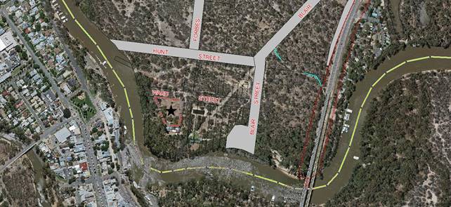
Proposal
The Applicant seeks consent to amend the approval by
altering the subject structure from a manufactured home to a building (dwelling
house), and reduce setback of the structure from the bank of the Murray River
from 100m to 80m. Please see below figures for more information.
Figure 2 – Submitted
site plan
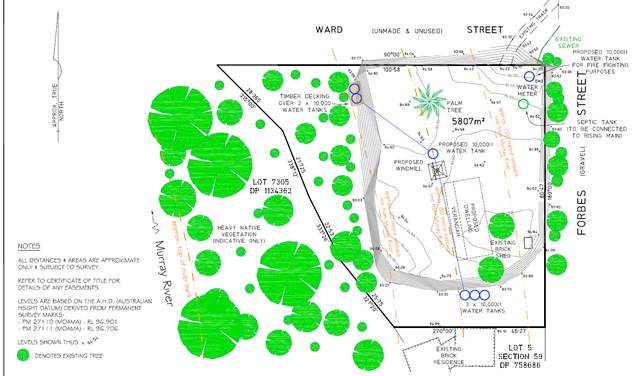
Figure 3 – Submitted
Elevations
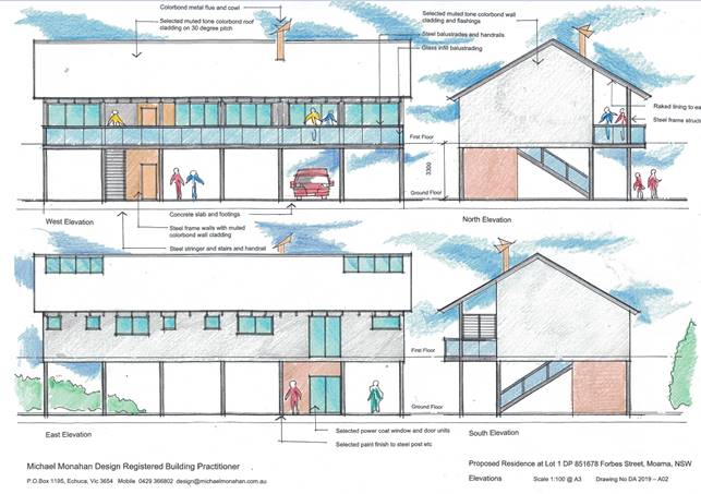
Statutory Assessment Process
2.1 Environmental
Planning and Assessment Act 1979
Section
1.3 Objects
Comment: The original assessment report outlined the
following in relation to the Objects of the Act:
“Having regard to the following report it is
questionable whether the proposed development is consistent with relevant
objects of the Environmental Planning and Assessment Act 1979 (the
“Act”) including the following:
(a) to promote the social and economic welfare of the
community and a better environment by the proper management, development and
conservation of the State’s natural and other resources,
(h) to promote the proper construction and maintenance of
buildings, including the protection of the health and safety of their
occupants”,
It is considered that the proposed modified development does
not alter this assessment.
Section 1.7 Application of Part 7 of Biodiversity
Conservation Act 2016 and Part 7A of Fisheries Management Act 1994
Comment: The Applicant has confirmed no vegetation is
required to be removed. It is therefore considered that the proposed modified
development will not have a significant effect on the terrestrial and aquatic
environment, threatened species, populations or ecological communities, or
their habitats. As the Applicant confirmed no vegetation is required to be
removed, the modified proposal is not considered to create any significant
adverse environmental impact. It is therefore considered that the proposal is
not inconsistent with Part 7 of the Biodiversity Conservation Act 2016
and Part 7A of the Fisheries Management Act 1994.
Section 4.14 Consultation and development
consent—certain bush fire prone land
Comment: The land is mapped as bushfire prone. The Applicant has provided a Bushfire Attack Level (BAL) Risk
Application which outlines the dwelling is to be constructed with a BAL rating
of 29. The modified application was referred to NSW Rural Fire Service (RFS)
for comment. RFS provided correspondence outlining they did not concur with the
submitted BAL rating of 29, however did not object to the granting of modified
consent subject to conditions.
Section 4.15 Evaluation
Comment: This report provides the necessary review and
evaluation of the modified development application. See below.
Section 4.46 What is “integrated
development”?
Comment: The original application was classed as
Integrated Development with Heritage Council of NSW. The modified application
was therefore referred to Heritage Council of NSW under Clause 120 of the
Environmental Planning and Assessment Regulation 2000 (the Regulations). The
Heritage Council of NSW did not object to the granting of
modified consent subject to conditions.
Section 4.55 Modification of consents—generally
(1A) Modifications
involving minimal environmental impact
A consent authority may, on application being
made by the applicant or any other person entitled to act on a consent granted
by the consent authority and subject to and in accordance with the regulations,
modify the consent if:
Consideration
|
Comment
|
|
(a) it is
satisfied that the proposed modification is of minimal environmental impact,
and
|
Council is not satisfied that the proposed modification is
of minimal environmental impact. The submitted amendment seeks to reduce the
approved setback of the structure from 100m to 80m. This request is
inconsistent with Clause 7.4 ‘Development on river front areas’ of
the Murray Local Environmental Plan 2011, whilst Council’s legal advice
outlines the setback distance is a standard which cannot be varied.
|
|
(b) it is satisfied
that the development to which the consent as modified relates is
substantially the same development as the development for which the consent
was originally granted and before that consent as originally granted was
modified (if at all), and
|
It is considered that the proposed modified development is
substantially the same as the original development.
|
|
(c) it has
notified the application in accordance with:
(i) the
regulations, if the regulations so require, or
(ii) a
development control plan, if the consent authority is a council that has made
a development control plan that requires the notification or advertising of
applications for modification of a development consent, and
|
The modified application was notified in accordance with
the Regulations and Chapter 12 of Council’s Development Control Plan.
|
|
(d) it has
considered any submissions made concerning the proposed modification within
any period prescribed by the regulations or provided by the development
control plan, as the case may be.
Subsections
(1), (2) and (5) do not apply to such a modification.
|
All submissions have been considered during this
assessment.
|
2.2 Contributions
Section 7.11 (formally Section 94) Development Contributions
are not required.
Section 7.12 (formally Section 94A) Levy Development
Contributions are required.
Section 64 contributions are not required.
Town Planning Assessment
Assessment of the modified development application has been
undertaken in respect to relevant considerations arising from Section 4.15 of
the Environmental Planning and Assessment Act 1979 as follows:
3.1 Section 4.15 Evaluation
(1) Matters for consideration-general
In
determining a development application, a consent authority is to take into
consideration such of the following matters as are of relevance to the
development the subject of the development application:
(a) the
provisions of:
(i) any environmental
planning instrument, and
(ii) any
proposed instrument that is or has been the subject of public consultation
under this Act and that has been notified to the consent authority (unless the Planning
Secretary has notified the consent authority that the making of the proposed
instrument has been deferred indefinitely or has not been approved), and
(iii) any
development control plan, and
(iiia) any
planning agreement that has been entered into under section 7.4, or any draft
planning agreement that a developer has offered to enter into under section 7.4,
and
(iv) the
regulations (to the extent that they prescribe matters for the purposes of this
paragraph), and
(v) repealed,
that apply to the land to which the development application
relates,
(b) the
likely impacts of that development, including environmental impacts on both the
natural and built environments, and social and economic impacts in the
locality,
(c) the
suitability of the site for the development,
(d) any
submissions made in accordance with this Act or the regulations,
(e) the
public interest.
Matters for
consideration
3.2(a) the provisions
3.2(a)(i) Environmental Planning
Instruments
3.2.1 Murray Local
Environmental Plan 2011
Part 1 Preliminary
Clause 1.2 Aims of Plan
Comment: The original assessment against this clause
outlined the following:
“Having regard to the following report it is
questionable whether the proposed development is consistent with relevant aims
of Murray LEP 2011 including the following:
(a)
to encourage sustainable economic growth and development within Murray,
(c)
to identify, protect, conserve and enhance Murray’s natural assets,
(f)
to encourage and focus growth in the Moama and Mathoura townships”,
The proposed modified development does not alter this
assessment.
Clause 1.9A Suspension of covenants, agreements and
instruments
Noted: For the purpose of enabling development on
land in any zone to be carried out in accordance with this Plan or with a
consent granted under the Act, any agreement, covenant or other similar
instrument that restricts the carrying out of that development does not apply
to the extent necessary to serve that purpose.
Part 2 Permitted or prohibited development
Zone: E3 Environmental Management
Objectives
of zone
• To
protect, manage and restore areas with special ecological, scientific, cultural
or aesthetic values.
• To
provide for a limited range of development that does not have an adverse effect
on those values.
Comment: It is considered that the proposed reduction
of setback from 100m to 80m to the Murray River is unlikely to protect the
subject development site and is therefore inconsistent with the objectives of
the zone.
Part 3 Exempt and complying
development
Comment: Not applicable.
Part 4 Principal development standards
Clause 4.2A Erection of dwelling houses on land in
certain rural and environmental protection zones
Comment: The original assessment outlined that the
proposal does not comply with this clause. See original assessment attached.
The proposed modification therefore continues to be inconsistent with this
clause (with the exception of the manufactured home classification which is
addressed by the proposed amendment to construct a building instead).
Clause 4.6 Exceptions to development standards
Comment: Council’s legal advice outlines that
the required 100m setback from the Murray River as outlined in Clause 7.4 of the
Murray LEP 2011 is unable to be varied under Clause 4.6.
Part 5 Miscellaneous provisions
Clause 5.10 Heritage conservation
Comment: The site is
located within the NSW State significant Heritage Conservation Area known as
‘Moama historic precinct’ (Item No. C1). The modified Application
was therefore referred to Heritage Council of NSW under Clause 120 of the
Environmental Planning and Assessment Regulation 2000 (the Regulations). The
Heritage Council of NSW did not object to the granting of modified
consent subject to conditions.
Clause 5.10 Subdivision of, or dwellings on, land in
certain rural, residential or environment protection zones
Comment: It is
considered that the modified proposal is not specifically inconsistent with the
requirements of this clause.
Part 7 Additional local provisions
Clause 7.1 Essential services
Development consent must not be granted to development
unless the consent authority is satisfied that any of the following services
that are essential for the proposed development are available or that adequate
arrangements have been made to make them available when required:
|
Subclause
|
Comment
|
|
(a) the supply of water,
|
Private reticulated water supply is
available.
|
|
(b) the supply of
electricity,
|
Electricity is available.
|
|
(c) the disposal and
management of sewage,
|
The subject land is capable of connection to a private
reticulated sewer service.
|
|
(d) stormwater drainage or
on-site conservation,
|
Able to comply.
|
|
(e) suitable road access
|
Although accessed via Forbes Street this road does not
afford flood free access for residents or essential facilities and services.
|
Clause 7.2 Earthworks
Comment: While no earthworks apart from those associated with
building footings would be proposed as a part of this modified application it
is observed from the site inspection as well as perusal of Aerial Photography
(2010 - 2017 Nearmaps) that there appears to have been some earth forming and
possibly filling of part of the subject land.
Clause 7.3 Biodiversity protection
Comment: The land is mapped as Terrestrial
Biodiversity. Subclause (3) outlines:
(3) Before determining a development
application for development on land to which this clause applies, the consent
authority must consider whether or not the development:
(a) is likely to have any
adverse impact on the condition, ecological value and significance of the fauna
and flora on the land, and
(c) has any potential to
fragment, disturb or diminish the biodiversity structure, function and
composition of the land, and
(d) is likely to have any
adverse impact on the habitat elements providing connectivity on the land.
Although the applicant has advised no clearing of vegetation is required,
no information to specifically address the decision criteria as outlined at
Clause 7.3(3) has been provided. The modified application is therefore
considered to be deficient in that regard.
Clause 7.4 Development on river front areas
(1)
The objectives of this clause are as follows—
(a) to
support natural riverine processes, including the migration of the Murray and
Wakool Rivers’ channels,
(b) to
protect and improve the bed and bank stability of those rivers,
(c) to
maintain and improve the water quality of those rivers,
(d) to
protect the amenity, scenic landscape values and cultural heritage of those
rivers and to protect public access to their riverine corridors,
(e) to
conserve and protect the riverine corridors of those rivers, including wildlife
habitat.
Comment: The subject land contains land classed as a
river front area. The modified proposal is inconsistent with the objectives of
the clause due to the proposed 80m setback of the dwelling from the Murray
River which is prohibited within the river front area.
(2)
Despite any other provision of this Plan, development consent may only be
granted to development on land in a river front area for the following
purposes—
(a) boat
building and repair facilities, boat launching ramps, boat sheds, charter and
tourism boating facilities or marinas,
(b) the
extension or alteration of an existing building that is wholly or partly in the
river front area, but only if the extension or alteration is to be located no
closer to the river bank than the existing building,
(c) environmental
protection works,
(d) extensive
agriculture and intensive plant agriculture,
(e) environmental
facilities and recreation areas,
(f) water
recreation structures.
Comment: The modified proposal is prohibited under the
terms of Clause 7.4 as it relates to a type of development that is not provided
for under clause 7.4(2).
(3)
Development consent must not be granted under subclause (2) unless the consent
authority is satisfied of the following—
(a) that
the appearance of the development, from both the river concerned and the river
front area, will be compatible with the surrounding area,
(b) that
the development is not likely to cause environmental harm, including (but not
limited to) the following—
(i) pollution
or siltation of the river concerned,
(ii) any
adverse effect on surrounding uses, riverine habitat, wetland areas or flora or
fauna habitats,
(iii) any
adverse effect on drainage patterns,
(c) that
the development is likely to cause only minimal visual disturbance to the
existing landscape,
(d) that
continuous public access, and opportunities to provide continuous public
access, along the river front and to the river concerned are not likely to be
compromised,
(e) that
any historic, scientific, cultural, social archaeological, architectural,
natural or aesthetic significance of the land on
which the development is to be carried out and of surrounding land is to be
maintained.
Comment: As the proposed reduction to river setback
is prohibited, the modified proposal therefore does not comply with the
requirements of the clause.
Clause 7.5 Riparian land and Murray River and other
watercourses—general principles
Comment: Not applicable.
Clause 7.6 Additional
provisions—development on river bed and banks of the Murray and Wakool
Rivers
Comment: Not applicable.
Clause 7.7 Wetlands
Comment: The land is mapped as Wetlands. Subclause (3)
outlines:
(3) When assessing a development application, the
consent authority must consider potential adverse impacts from the proposed
development on:
(a) the growth and survival of native flora and
fauna, and
(b) the condition and significance of the native
flora on the land and whether it should be substantially retained, and
(c) the provision and quality of habitats for
indigenous and migratory species, and
(d) the surface and groundwater characteristics of
the site, including water quality, natural water flows and salinity, and
(e) any wetland in the vicinity of the proposed
development, and any proposed measures to minimise or mitigate those impacts.
The applicant has provided no information to specifically
address the decision criteria as outlined at Clause 7.7(3). The application is therefore
considered to be deficient in that regard.
Clause 7.8 Flood planning
Comment: The original assessment outlined that the
proposal does not comply with this clause. See original assessment attached.
The proposed modification therefore continues to be inconsistent with this
clause (with the exception of the manufactured home classification which is
addressed by the proposed amendment to construct a building instead).
3.2.2 Murray Regional Environmental Plan No. 2—Riverine Land
Comment: The subject site is mapped as Murray
Regional Environmental Plan 2 – Riverine Land.
Part 1 Introduction
Clause 2 Aims of the plan
Comment: The original assessment outlined the
following:
“Given the proximity
of the subject land from the high bank of the river it might be argued that the
development does nothing to address the aims of REP2 to conserve and enhance
the riverine environment of the River Murray.
The subject land is
however already cleared and the proposed building site is relatively well
screened from the waterway itself so at best the proposal might be regarded as
being neutral in this regard”.
The proposed modified development does not alter this
assessment.
Clause 3 Objectives of the plan
Comment: Noted.
Part 2 Planning
principles
Clause 9 General principles
Comment: The proposed modified development is
considered to be not inconsistent with the general principles of this plan. The
proposed modified development is unlikely to significantly adversely affect the
River Murray.
Clause 10 Specific principles
Comment: The proposed modified development is
considered to be not inconsistent with the specific principles of this plan,
with the exception of subclauses ‘Flooding’ and
‘Settlement’.
Part 3 Planning requirements and consultation
Clause 13 Planning
Control and Consultation Table
Comment: The modified application was not required to
be referred under this plan.
Clause 14 Building setbacks—special
provisions
(1) Application This clause deals with matters
which are to be taken into consideration when—
(a) a consent authority determines a development
application, or
(b) a public authority or person proposes to carry
out development for which development consent is not required but which has the
potential to adversely affect the riverine environment of the River Murray.
Comment: Noted.
(2) Building
setback All buildings outside land zoned for urban purposes under a local
environmental plan should be set well back from the bank of the River Murray.
The only exceptions are buildings dependent on a location adjacent to the River
Murray.
Comment: The proposed modified development is inconsistent
with this subclause. The reduction of setback from 100m to 80m from the bank of
the Murray River is not classed as an exception where the building is dependent
on the location.
(3) Objectives of building setback The objectives
of siting buildings away from the River Murray are to—
• maintain and improve water quality,
• minimise hazard risk and the redistributive
effect on floodwater associated with the erection of buildings on the
floodplain,
• protect the scenic landscape of the
riverine corridor,
• improve bank stability, and
• conserve wildlife habitat.
Comment: The objectives of the clause are noted.
(4) Matters to be considered When determining the
location of a building in relation to the River Murray, in addition to the
planning principles the following specific matters should also be
considered—
(a) Effluent disposal
(i) it is generally unsuitable to locate septic
tanks—
• on flood liable land,
• where the watertable is within 2 metres of
the surface,
• in close proximity to a sensitive natural
environment,
• if seasonably low evapotranspiration is
common, or
• on soils of low permeability,
(ii) septic tanks should only be installed on
suitable (ie permeable) soils with absorption areas located as far as possible
from the River Murray or other drainage lines,
(iii) in circumstances where septic tanks are
unsuitable, package sewage treatment plants or humus closet (dry toilet)
systems should be preferred,
(iv) excess stormwater should, where possible, be
disposed of on-site away from any septic absorption area.
Comment: Noted.
(b) Landscaping
The visual impact of buildings in the riverine landscape
can be lessened by the planting of a variety of appropriate vegetation species.
This practice has other advantages in stabilising unstable or eroding banks and
providing both habitat for wildlife and a trap for silt, nutrients and other
substances which may otherwise enter the river and lead to a deterioration of
water quality.
Comment: Noted.
3.2.3 State Environmental
Planning Policy (Koala Habitat Protection) 2019
Comment: The subject land is not considered to be
core koala habitat or potential core koala habitat.
3.2.4 State Environmental
Planning Policy No 55—Remediation of Land
Comment: The subject land is not considered to be
contaminated or likely to be contaminated and is not listed on Council’s
Contaminated Land Register. In reference to Clause 7 of the SEPP, Council is
satisfied that, the land is suitable in its current state for the purpose for
which the modified development is proposed to be carried out.
3.2.5 State Environmental
Planning Policy (Building Sustainability Index: BASIX) 2004
Comment: The modified proposal relates to a BASIX
affected development. A valid BASIX certificate (1080720S dated 7/03/2020) has
been submitted with the application. Plans appear to be consistent with BASIX
commitment.
3.2.6 State Environmental
Planning Policy (Exempt and Complying Development Codes) 2008
Comment: The proposed modified development cannot be
classed as exempt or complying development as it does not meet all of the
development requirements.
3.2.7 State Environmental
Planning Policy (Primary Production and Rural Development) 2019
Comment: The proposed
modified development is not specifically inconsistent with this Policy.
3.2.8 State Environmental
Planning Policy (Vegetation in Non-Rural Areas) 2017
Comment: The Applicant
has stated no vegetation is required to be removed. It is therefore considered
that the proposed modified development is not inconsistent with this Policy.
3.2(a)(ii) Proposed instruments
Comment: There are a number of draft amendments to
Murray LEP 2011 that have been the subject of public consultation under the
Act. While these draft amendments apply to land within Murray River Council it
is noted that none of these Amendments specifically change the provisions
affecting the subject land. As a consequence there are no relevant issues
identified.
3.2(a)(iii) Any development control plan
Comment: Murray
Development Control Plan 2012: Amendment 5 dated 2/2/2016 applies to the modified
proposal.
|
DCP Chapter
|
Comment
|
|
Chapter 2
Residential Development
|
The modified proposal
is not specifically inconsistent with this Chapter.
|
|
Chapter 6 Strategic
Land Use Plan
|
The original assessment outlined the following:
The proposal relates
to a dwelling on E3 zoned land not being land either required for urban
expansion or land that is considered to be productive agricultural land.
This notwithstanding
the proposal can be considered to be inconsistent with the vision of Council
for land use planning to ensure that the Shire’s natural environment is
carefully managed and that its natural and built assets are protected from
inappropriate rural and urban development that would prejudice the
agricultural, heritage and urban attributes of the Shire.
The proposed modified development does not alter this
assessment.
|
|
Chapter 9 Vegetation
Removal
|
The applicant has
advised that no vegetation is required to be removed.
|
|
Chapter 10
Watercourses & Riparian Land
|
The modified proposal
is not specifically inconsistent with this Chapter.
|
|
Chapter 11 Flood
Prone Land
|
The original assessment outlined that the proposal does
not comply with this chapter. See original assessment attached. The proposed
modification therefore continues to be inconsistent with this chapter (with
the exception of the manufactured home classification which is addressed by
the proposed amendment to construct a building instead).
|
|
Chapter 12
Notification Policy
|
Noted.
|
3.2(a)(iiia)
Any Planning Agreements
Comment: No planning agreements apply.
3.2(a)(iv)
The regulations
Comment:
The regulations have been considered in the assessment of this modified
application. It is considered that the proposal is not inconsistent with the
objectives of the regulations.
3.3(b) the
likely impacts of that development, including environmental impacts on both the
natural and built environments, and social and economic impacts in the
locality.
The original assessment outlined the following:
“Comment: The subject land is essentially a small vacant parcel
situated adjacent to the Murray River opposite the Echuca Wharf. While there is
some scattered development nearby the land on the NSW side, the property itself
sits in an otherwise largely undeveloped riverine landscape setting surrounded
by riparian forest. This in part forms a basis for the designation of the
Heritage Conservation Area opposite the Echuca Wharf.
Given its location as well as
the overall characteristics of the immediate locality, the impact upon the
riverine environment is considered to be negative. The economic and social
impacts are considered to be largely neutral and having no significant influence
in determining the application...”
The proposed modified
development does not alter this assessment.
3.4(c) The
suitability of the site for the development
Comment: The original assessment outlined the
following:
“Having regard to site context and existing functions
of the subject land it is considered that in sufficient supporting
documentation has been provided to demonstrate that the land is suitable for
the proposed development”.
The proposed modified
development does not alter this assessment.
3.5(d) any
submissions made in accordance with this Act or the regulations,
|
Agency
|
Response
|
|
Heritage
Council of NSW
|
No objections
subject to conditions.
|
|
NSW RFS
|
Correspondence
received outlining they do not concur with the submitted BAL rating of 29,
however did not object to the granting of modified consent subject to
conditions.
|
|
Department of
Planning, Industry and Environment – Biodiversity Conservation Division
|
No
objections, comments received.
|
Public
Submissions
No public
submissions were received.
3.6(e) The
public interest.
Comment: The public’s interest has been taken
into consideration in the assessment of this modified development application. It is considered
that the modified proposal may have adverse amenity and/or
environmental impacts. As a consequence it is concluded that there is no public
benefit associated with the modified proposal.
Conclusion
The proposed
development has been assessed in accordance with the provisions of Section 4.15
& Section 4.55 of the Environmental Planning and Assessment Act 1979
and is considered to be non-satisfactory.
Although the
proposal is inconsistent with a number of planning requirements, as outlined
throughout the report, and is therefore recommended for refusal, Council may
consider that the difference between the manufactured home approved and the
proposed dwelling in this application may in fact be a better outcome from a
planning and environmental perspective. It should also be noted that an existing
dwelling is located on the adjacent lot which is actually closer to the river
than the proposal. If therefore, Council wished to approve
this amendment it would be considered based on the previous approval by Council
(17 July 2018) for a manufactured home to be developed on the site, with the
opportunity for an improved structure to be on site (a dwelling house), with no
significant environmental impacts. Acknowledging that the reduced riverfront
setback would still not be addressed.
Attachments
1. DA
115/13 Original Deferred Commencement Consent ⇩ 
2. Assessment
Report of Original DA 115/13 (under separate cover) 
3. Original
DA 115/13 Resolution - Minutes of MRC Ordinary Meeting held 17 July 2018 ⇩
|
MURRAY RIVER
COUNCIL Ordinary Council Meeting Agenda
|
26 May 2020
|
|
MURRAY RIVER COUNCIL Ordinary
Council Meeting Agenda
|
26 May 2020
|
8.4.6 Development Application
10.2019.284.1 - 368 Lot Torrens Title Subdivision
File
Number: -
Author: Gayan
Wickramasinghe, Town Planner
Authoriser: David
Wilkinson, Director Planning, Waste & Regulatory Services
Applicant: Habitat
Planning
Owner: Swedzah
Pty Limited and R & M Perry P/L
Proposal: 368
Lot Torrens Title Subdivision, including two public reserves and ancillary
earthworks
Location: Lot
11, DP 701453, Beer Road, Moama
|
Recommendation
1. That the
Officer’s report on Development Application 10.2019.284.1 – 368
Lot Torrens Title Subdivision be received and noted by the Council.
2. That approval be granted to
Development Application 10.2019.284.1
for 368 Lot Torrens Title Subdivision, including two public reserves
and ancillary earthworks on Lot 11,
DP701453, subject to the conditions outlined
in the report.
|
Background
This report provides an assessment of Development
Application (DA) 10.2019.284.1 for a residential subdivision involving 368
residential lots and two public reserves at Lot 11, DP701453, Beer Road, Moama.
As per the Murray River Council adopted ‘Delegated
Authority for the Assessment of Development Applications Policy’
(POL400.V1), section 7.2 which outlines that development applications
for approval involving substantial aspects of the following elements be
referred to the Council for determination:
- When,
in the opinion of Council’s Director Planning, Waste and Regulatory
Services, the development is significant in its content.
Following public exhibition
of the DA from 1 April 2020 to 4 May
2020, Council received seven (7)
submissions. Accordingly, this matter is reported to the Council for
determination.
Discussion
Subject
Site
The site subject to this development application is located
at Beer Road Moama 2731 on Lot 11, DP701453. Land size is 58.78 ha. The subject
development site is a rectangular shaped allotment
and has been historically cleared of vegetation with the exception of a
stand of remnant Grey box trees on the southern boundary. The site is zoned R1
General Residential and is mapped as Murray Regional Environmental Plan No. 2
– Riverine Land. A small proportion of the northern section of the site
is mapped as bush fire prone land. The subject development site does not
contain any known items of environmental heritage significance.
As per applicant’s documentation, the land has been
used for dryland agriculture (cropping and grazing) for many decades. Towards
the western end of the northern boundary is a small partially
developed residential estate. The subject land
has two street frontages with the sealed Twenty Four Land on the western side
and the unsealed Beer Road along the southern side. Figures
1 and 2 outline the subject site.
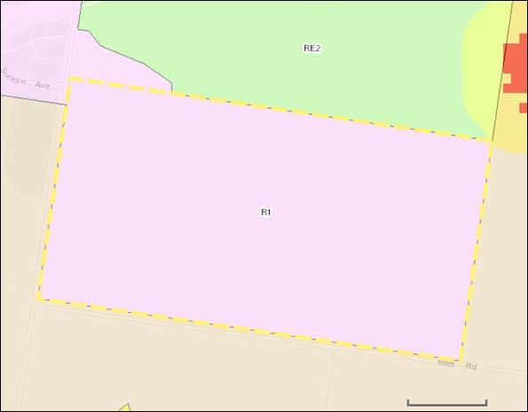
Figure 1 –
Locality (Source: ePlanning Spatial Viewer NSW 2019)
Figure 2 – Aerial photograph of
subject site. Subject site marked with a yellow polygon.
(Source: Six Maps
NSW 2019)
Proposal
The applicant is seeking
permission for subdivision of residential land identified as Lot 11 DP 701453
into 368 lots in thirteen stages, lot sizes ranging from 750m2 to
999m2, 1000m2 to 1500m2 and above 1500 m2.
The proposal also includes two public reserves. One reserve is located at the southern boundary of the
development site by incorporating the existing vegetation. The other public
reserve is proposed as part of the stage 10 subdivision works of the proposed
development. As per submitted documentation, access will be gained
from both Twenty Four Lane with a second access in Beer Road as part of later
stages.
Works required for the
subdivision to be carried out include earthworks, internal road construction,
and provision and extension of infrastructure services including sewerage,
water supply, storm water infrastructure, electricity and
telecommunications.
The applicant has also provided the following details to
support the application:
1. Plan
of proposed subdivision including; Staging Plan, Road Grading Strategy,
Servicing Plan and the Drainage Plan,
2. The
completed application form
3. An
assessment against relevant planning controls
4. Other
supporting documents(The Biodiversity Offset Scheme Entry Threshold report
(BOSET), Aboriginal Heritage Information Management System (AHIMS) search and a
revised Traffic Impact Assessment report, Bushfire Assessment Report and a
spray drift report)
The proposed subdivision plan is included as Attachment
A.
Statutory Assessment Process
2.1 Environmental
Planning and Assessment Act 1979
Section
1.3 Objects
Comment: It is considered that the proposed
development is not inconsistent with the objects of the Act.
Section 1.7 Application of Part 7 of Biodiversity
Conservation Act 2016 and Part 7A of Fisheries Management Act 1994
Comment: It is considered that the proposed
development will not have a significant effect on the terrestrial and aquatic
environment, threatened species, populations or ecological communities, or
their habitats. The proposal is not considered to create any significant
adverse environmental impact. It is therefore considered that the proposal is
not inconsistent with Part 7 of the Biodiversity Conservation Act 2016
and Part 7A of the Fisheries Management Act 1994. The applicant was
referred to the Biodiversity Conservation Division of the Department of
Planning, Industry and Environment. They did not object to the proposal subject
to conditions.
Section 4.14 Consultation and development
consent—certain bush fire prone land
Comment: As per NSW ePlanning Spatial Viewer, the
north eastern corner of the development site is mapped as Bushfire Prone Land.
According to the Rural Fires Act 1997 the applicant requires to obtain a
bushfire safety authority for the following;
(a) a
subdivision of bush fire prone land that could lawfully be used for residential
or rural residential purposes…
A Bush Fire Safety Authority (BFSA) is therefore required
from the NSW Rural Fire Service (RFS). The application is accompanied with a
Bush Fire Assessment Report and was referred to RFS seeking general terms of
approval.
Section 4.15 Evaluation
Comment: This report provides the necessary review and
evaluation of the development application. See below.
Section 4.46 What is “integrated
development”?
Comment: The application is classed as
Integrated Development with RFS as it requires a separate approval under Rural
Fires Act 1997.
2.2 Chronology of events and
public notification and statutory referral process.
The below table provides an overview of the timeline with
respect to the lodgement and assessment of the application.
Application history/timeline
|
Application
lodged
|
11/11/2019
|
|
Neighbour
Notification
|
01/04/2020
to 04/05/2020
|
|
Further
information requested
|
02/12/2019
|
|
Further
information received
|
26/03/2020
|
|
Site
Inspection
|
18/03/2020
|
2.3 Referrals and Owners Consent
|
Internal
Referrals
|
DA Panel
Engineering
Department
Waste
Department
|
|
External
Referrals
|
NSW EPA
Biodiversity
Conservation Division of the Department of Planning, Industry and Environment
(DPIE BCD)
Water NSW
Crown
Lands - Department of Planning, Industry and Environment
Murray
Darling Basin Authority
NSW Rural
Fire Service
Natural
Resources Access Regulator
NSW
Department of Primary Industries – Fisheries
NSW
Department of Primary Industries- Agriculture
Transport
for NSW (Formally known as RMS)
|
|
Advertised
|
The
proposed subdivision is identified as Wetland Subdivision under the REP 02
Murray Regional Environmental Plan No 2- Riverina Land. It is also noted that
the proposed development is identified as Integrated Development in
accordance with Section 4.46 of the Environment Planning and
Assessment Act 1979. Therefore, the application was
advertised in the Riverina Herald on 2 occasions as per Murray DCP 2012
Notification Policy.
|
|
Public
Notification
|
The
proposed development was notified to adjoining property owners for 30 days in
accordance with Murray DCP 2012 Chapter 12 – Notification Policy.
|
|
Owners
Consent
|
Provided
|
2.4 Contributions
Section 7.11 (formerly Section 94) Development Contributions
are required. Please refer to the condition section.
Section 7.12 (formerly Section 94A) Levy Development
Contributions are not required.
Section 64 contributions are required. Please refer
to the condition section.
Town Planning Assessment
Assessment of the development application has been
undertaken in respect to relevant considerations arising from Section 4.15 of
the Environmental Planning and Assessment Act 1979 as follows:
3.1 Section 4.15 Evaluation
(1) Matters for consideration-general
In
determining a development application, a consent authority is to take into
consideration such of the following matters as are of relevance to the
development the subject of the development application:
(a) the
provisions of:
(i) any environmental
planning instrument, and
(ii) any
proposed instrument that is or has been the subject of public consultation
under this Act and that has been notified to the consent authority (unless the
Planning Secretary has notified the consent authority that the making of the
proposed instrument has been deferred indefinitely or has not been approved),
and
(iii) any
development control plan, and
(iiia) any
planning agreement that has been entered into under section 7.4, or any draft
planning agreement that a developer has offered to enter into under section
7.4, and
(iv) the
regulations (to the extent that they prescribe matters for the purposes of this
paragraph), and
(v) (Repealed)
that apply to the land to
which the development application relates,
(b) the
likely impacts of that development, including environmental impacts on both the
natural and built environments, and social and economic impacts in the
locality,
(c) the
suitability of the site for the development,
(d) any
submissions made in accordance with this Act or the regulations,
(e) the
public interest.
Matters for
consideration
3.2(a) the provisions
3.2(a)(i) Environmental Planning
Instruments
3.2(a)(i)a Murray Local Environmental
Plan 2011 (Available:
http://www.legislation.nsw.gov.au/#/view/epi/2011/682)
Part 1 Preliminary
Clause 1.2 Aims of Plan
Comment: The proposed development will
encourage sustainable economic growth and focus growth in the Moama Township.
Therefore, it is considered that the proposed development is consistent
with the aims of Murray LEP 2011.
Clause 1.9A Suspension of covenants, agreements and
instruments
Comment: For the purpose of enabling development on
land in any zone to be carried out in accordance with this Plan or with a
consent granted under the Act, any agreement, covenant or other similar
instrument that restricts the carrying out of that development does not apply
to the extent necessary to serve that purpose.
Part 2 Permitted or prohibited development
Clause 2.3 Zone objectives and Land Use Table (development
permissibility)
Zone: R1 General Residential
§ To provide for the housing needs
of the community.
§ To provide a variety of housing
types and densities.
§ To enable other land uses that
provide facilities or services to meet the day-to-day needs of residents.
§ To avoid potential land use
conflict and protect the amenity of residents.
§ To provide for tourist and
visitor accommodation in appropriate locations.
Comment: The proposed subdivision is proposed to have
different lot sizes within land zoned R1 General Residential. It will provide a variety of housing types and densities. Therefore the proposed
residential subdivision is consistent with the objectives of R1 General
Residential Zone.
Permissibility
Comment: As per Clause 2.6 of Murray LEP 2011, the
proposed Torrens Title Subdivision is permitted with Council consent.
Clause 2.6
Subdivision—consent requirements
Comment: The proposed
Torrens Title Subdivision is permissible with Council Consent. It is also noted
that the proposed subdivision is not considered to be exempt development. As
per Murray LEP 2011, the proposed lots are not less than the
minimum size shown on the Lot Size Map in relation to that land.
Part 4 Principal development standards
Clause 4.1 Minimum subdivision lot size
Comment: Lot sizes of the proposed subdivision is on
or above 750m2, which meet the minimum size shown on
the Lot Size Map in relation to that land.
Part 5 Miscellaneous provisions
Clause 5.10 Heritage conservation
Comment: The site does not contain any known items of
Environmental Heritage Significance. It is the responsibility of the Applicant
to ensure compliance with the Due Diligence Code of Practice for the
Protection of Aboriginal Objects in New South Wales. Any consent issued
will contain the standard DPIE BCD condition regarding protection of Aboriginal
Cultural Heritage.
Part 6 Urban release areas
Comment: Not applicable
Part 7 Additional local provisions
Clause 7.1 Essential services
Development consent must not be granted to development
unless the consent authority is satisfied that any of the following services
that are essential for the proposed development are available or that adequate
arrangements have been made to make them available when required:
|
Subclause
|
Comment
|
|
(a) the
supply of water,
|
As per
applicant’s documentation, reticulated water supply will provide as an
extension from Council reticulated system. Council’s Engineering
Department did not object to this arrangement subject to conditions.
|
|
(b) the
supply of electricity,
|
A condition
will be imposed stating that prior to release of the subdivision certificate
for each stage, the applicant must provide electricity to each allotment.
Council’s Engineering Department did not object to this arrangement.
|
|
(c) the
disposal and management of sewage,
|
As per
applicant’s documentation, reticulated sewer supply will be provided as
an extension from Council reticulated system. Council’s
Engineering Department did not object to this arrangement subject to
conditions.
|
|
(d) stormwater
drainage or on-site conservation,
|
As per
applicant’s documentation, the applicant has proposed retention basins
within the development site and is also proposed to direct all storm water
generates from the development to the proposed reserve. Council’s
Engineering Department did not object to this arrangement subject to
conditions.
|
|
(e) suitable
road access
|
The proposed development
includes two accesses from both Twenty Four Land on the western side and Beer
Road along the southern side.
The application
is also incorporated with a Road Grading Strategy plan. As per plan; each lot will have direct or indirect access
to proposed internal roads. It is also noted, that pedestrian pathways
are incorporated into
the internal road network. The proposed a Road Grading Strategy plan was
referred to Council’s Engineering Department. They did not object to
the proposal subject to conditions.
|
Clause 7.2 Earthworks
Comment: During
the site inspection, it was revealed that the topography of the proposed
development site is flat to gentle slope. It is further noted that the
applicant has also proposed a stormwater drainage reserve in the middle of the
development site for the management of stormwater across the subject land from
the adjoining golf club to Beer Road. These proposed activities will require
some minor earth works and site preparation works. It is considered that the
proposed earthworks are of a minor nature and will not have a
detrimental impact on environmental functions and processes, existing drainage
patterns, neighboring uses, cultural or heritage items or features of the
surrounding land. A number of
measures to address potential impacts associated with the earthworks will be
conditioned with any consent granted. These include measures for dust
control and sediment and erosion control.
Clause 7.3 Biodiversity protection
Comment: Not applicable. The subject site is not
covered by Council’s biodiversity mapping.
Clause 7.4 Development on river front areas
Comment: Not applicable. The subject land is not
classed as a river front area.
Clause 7.5 Riparian land and Murray River and other
watercourses—general principles
Comment: Not applicable. The proposed development is
not occurring on riparian land.
Clause 7.6 Additional
provisions—development on river bed and banks of the Murray and Wakool Rivers
Comment: Not applicable.
Clause 7.7 Wetlands
Comment: Not applicable.
Clause 7.8 Flood planning
Comment: As per Murray LEP 2011, the subject site is
not mapped as flood prone land. However as per 7.8 (2) of Murray LEP 2011,
Council still have to consider other land at or below the flood planning level.
According to the Moama Floodplain Management Study carried out by the former
Murray Shire Council in 2001, more than half of the development site would be
inundated during a Probable Maximum Flood (PMF) event. However,
the subject development site was recently rezoned from RU1- Primary Production
to R1 – General Residential. As part of the rezoning process, the
planning proposal was referred to then the Office of Environment and Heritage
(OEH) for their respective comment. They initially responded that:
Whilst the site is located within the study area
of the Moama Floodplain Management Study (1999) there have been changes to
flood risk management policy and practice since 1999 which mean the mapping
presented in the study is not consistent with current policy and practice. The
Murray Local Environmental Plan 2011 includes flood mapping, however it is
understood the basis of those maps is also not consistent with current policy
and practice. OEH encourages Council to review and extend their flood study and
undertake a Flood Risk Management Study and Plan, to enable more robust
assessment of proposals such as this, consistent with current policy.
This rezoning proposal is required to be
consistent with the NSW Flood Prone Land Policy and the principles of the
Floodplain Development Manual 2005. Council should consider requesting the
proponent to undertake a more detailed flood study addressing the requirements
of the Flood Prone Land planning directions (section 4. 3) issued under Section
117 (2) of the Environmental Planning and Assessment Act 1979.
The above response was forwarded on to the applicant and the
applicant’s respective response was then forwarded on to OEH who
responded that:
As the proposal site is above the 1 in 100 year
flood level, we consider that this proposal is compliant with s117 Direction
4.3 for Flood Prone Area.
In light of the above response, Council is satisfied that
the development is compatible with flood hazard of the land is
not likely to significantly adversely affect flood behavior resulting in
detrimental increases in the potential flood affectation of other development
or properties, and is not likely to
result in unsustainable social and economic costs to the community as a
consequence of flooding.
3.2(a)(i)b Murray Regional Environmental Plan No. 2—Riverine Land
Comment: The proposed subdivision is considered
consistent with the aims and objectives of the Murray Regional Environmental
Plan No. 2, subject to appropriate conditions which will be
included in the development consent.
Part 1 Introduction
Clause 2 Aims of the plan
Comment: The proposed 368
Torrens Title subdivision with two public reserves is considered to be
consistent with the aims of this plan. The proposed development is unlikely to
detrimentally impact upon the riverine environment of the River Murray. In the event that Council approves this
application, conditions will be imposed to
ensure consistency.
Clause 3 Objectives of the plan
Comment: The proposed development
is generally considered to be consistent with the objectives of this plan.
Part 2 Planning principles
Clause 9 General principles
Comment: The proposed
development is not considered to be inconsistent with the general principles of
this plan. The development site is located well away from the Murray River or
any watercourse identified as River Murray. It is further noted that there is
no adopted river management plan within the Murray River Council.
Clause 10 Specific principles
Comment: The proposed
development is unlikely to have an impact on the riverine environment of the
River Murray. As previously discussed, flooding on the development site is
deemed to be the lowest risk category of ‘low hazard flood storage.
Part 3 Planning requirements and consultation
Clause 13 Planning
Control and Consultation Table
Comment: The development site is mapped as REP 02-
Riverina Land. The proposed development is classed as ‘STORMWATER DRAINAGE SCHEME’.
Therefore, the Application was referred to a number of Government agencies.
Please refer 3.5(d) any submissions made in accordance
with this Act or the regulations
Clause 14 Building setbacks—special
provisions
Comment: No buildings form part of this application. Therefore this clause is not applicable.
3.2(a)(i)f State Environmental
Planning Policy (Koala Habitat Protection) 2019
Comment: The subject land is not considered to be
core koala habitat or potential core koala habitat.
3.2(a)(i)g State Environmental
Planning Policy No 55—Remediation of Land
Comment: The subject land is not considered to be
contaminated or likely to be contaminated and is not listed on Council’s
Contaminated Land Register. In accordance with Clause 7 of SEPP 55, Council is
satisfied that, the land is suitable in its current state for the purpose for
which the development is proposed to be carried out.
3.2(a)(i)o State Environmental
Planning Policy (Exempt and Complying Development Codes) 2008
Comment: The proposed development cannot be classed
as exempt or complying development as it does not meet all of the development
requirements.
3.2(a)(i)p State Environmental
Planning Policy (Infrastructure) 2007
Comment: The proposed
subdivision creates 200 or more allotments; as such it is classed as
traffic-generating development in accordance with Clause 104 of the State
Environmental Planning Policy (Infrastructure) 2007. To satisfy the
requirements outlined in this Clause, the applicant provided a Traffic Impact
Assessment Report (TIAR) from a suitably qualified person. The report includes
predicted traffic amounts from the existing intersection of Beer Road and
Twenty-four Lane, new intersection of Twenty-four Lane including entrance to
across the road and new intersection to Beer Road. The TIAR concludes the
following information related to the development:
§ The additional traffic generated
by the subdivision will have a minimal impact on the existing operations of
Twenty-four Lane and Beer Road and the wider road network at years 2025 and
2033;
§ The provision of turning
treatments at the proposed intersection of Twenty-four Lane/Street A and Beer
Road/Street C and the upgrade of the existing intersection of Twenty-four
Lane/Beer Road will ensure safety and allow motorists to negotiate the turning
movements with minimal delays. All intersection movements operate with an
average LOS A;
§ The redesigned and incorporation
of the St Anne’s Winery left turn lane (AUL) into the layout of the
proposed CHRs intersection treatment of Twenty-four Land and Street A will
adequately cater for the existing traffic and B-double movements at the winery;
§ Sight distance criteria are met
for the proposed intersections of Twenty-four Lane/Street A and Beer Road/
Street C.
It is also noted that the TIAR has
made the following recommendations:
§ Murray River Council
concur with the locations and turning treatments at the proposed intersections
of Twenty-four Lane/Street A and Beer Road/Street C;
§ Murray River Council
concur with the incorporation of the St Anne’s Winery AUL into the layout
of the proposed CHRs intersection treatment of Twenty-four Land/Street A
This information was externally
referred to Transport for NSW and Council’s Engineering Department.
Neither Transport for NSW nor Council’s Engineering Department objected
to the proposed development subject to conditions.
3.2(a)(i)v State Environmental Planning Policy (Vegetation in Non-Rural Areas)
2017
Comment: The proposed
development site is zoned R1 General Residential. Therefore this
policy is applicable. However, as per supplied Statement of Environmental
Effects report, no vegetation is proposed to be removed.
3.2(a)(ii) Proposed instruments
Comment: Draft Murray LEP 2011 applies. No issues
identified.
3.2(a)(iii) Any development control plan
Comment: Murray
Development Control Plan 2012 (DCP) applies to the proposal. Relevant to this
application are the following Chapters of the DCP:
· Chapter 6 –
Strategic Land Use Plan
· Chapter 7 –
Subdivision
· Chapter 12 –
Notification Policy.
|
Chapter 6 – Strategic Land Use Plan
|
|
Response:
|
The proposal is consistent with the
SLUP. The development site is identified as future residential stage 1.
|
|
Chapter 7 – Subdivision
|
|
7.1 Context
|
|
Objective/s
To ensure that the layout and design
of a subdivision is consistent with and implements any objective, policy,
strategy or plan for the area.
Response:
Lot sizes of the proposed subdivision
are on or above 750m2, which meet the minimum size shown on the Lot Size Map in relation
to that land of Murray LEP 2011. The
proposed development also complies with the Murray Shire Strategic Land Use
Plan. It is further noted that the proposed development is also consistent
with the Moama mid-west drainage Investigation recommendations.
|
Control/s
Subdivision shall be consistent with
the Murray Shire Strategic Land Use Plan.
Response:
The proposed subdivision is consistent with the applicable
Section of the Murray Shire Strategic Land Use Plan. The development
site is identified as future residential stage 1.
|
|
7.2 Neighbourhood Character
|
|
Objective/s
To create urban places with identity
and character.
Response:
The proposed subdivision will facilitate
to increase residential densities for underutilised sites within the Murray
River Council. The proposed subdivision will support the demand for housing
as a result of population growth in the Council and therefore it will
contribute to enhancing the identity of the existing and preferred
neighbourhood character in existing urban areas.
Objective/s
To design subdivisions that are
consistent and compatible with existing development in the neighbourhood.
Response:
The proposed lot design is consistent
with the existing nearby residential development in the area. The subdivision includes stormwater
treatment measures, road grading strategy, sewer and water supply service
plans, which are consistent with contemporary residential subdivision design.
Council is satisfied that these design approaches are of an appropriate
design and will provide sufficient capacity.
Objective/s
Ensure a transition in density from
lower to higher density residential areas.
Response:
As per supplied subdivision master plan,
the proposal includes a variety of lot sizes ranging from 750m2 to 999m2, 1000m2
to 1500m2 and above 1500 m2. This will allow for a
diversity in housing form. This approach will facilitate smooth transition
between lower to higher density.
|
Control/s
Subdivision to be generally
consistent with the theme and character of development relating to the same
land use within the vicinity of the subject development.
Response:
The proposed subdivision layout has been
designed to encourage allotments which are orientated in a north-south
manner. It is further noted that the existing character of the area is made
up of a mix of small lots and large allotments. As discussed in this report,
the proposed development proposes to create lots of a size that on balance
provide for the development of future dwellings that will fit comfortably
within the context of the character of the surrounding area.
Control/s
Requests to vary minimum lot size on
land zoned residential west of Lignum Road will be considered by Council to
be inconsistent with the objectives for neighbourhood character.
Response:
The proposal does not seek to vary the
minimum lot size applying to the land.
|
|
7.3 Staging
|
|
Objective/s
To ensure the timely and efficient
release of urban land making provision for necessary infrastructure and
sequencing.
Response:
As per submitted plans, the proposed
Torrens Title subdivision is a staged development; which is proposed to be
undertaken in 13 development stages. A staging plan has been prepared by the
applicant.
|
Control/s
Where staging of a subdivision is
proposed, the lodgement of a staging plan with the development application.
Response:
The staging plan has been prepared by
the applicant and has been lodged with the development application. The
application was also internally referred to Council’s Engineering Department
for their respective comments. They did not object to the proposal subject to
conditions.
Control/s
Consistency with Councils Strategic
Land Use Plan.
Response:
As discussed in this report, the proposed subdivision is consistent with the applicable
Section of the Murray Shire Strategic Land Use Plan. The development
site is identified as future residential stage 1.
Control/s
Council will consider any subdivision
that is isolated from existing services and infrastructure or remote from existing
urban development as inconsistent with the objective of this control.
Response:
The proposed development site is allowed
convenient access by vehicle and/or pedestrians to existing Moama CBD and
Meninya Street.
|
|
7.4 Movement Network
|
|
Objective/s
To create compact
neighbourhoods that are oriented around easy walking distances to activity
centres, schools and community facilities, public open space and public
transport.
Response:
The proposed subdivision occurs in close
proximity to Moama CBD and easy walking distance to schools and community
facilities.
Objective/s
To allow easy movement through and
between neighbourhoods for all people.
Response:
The proposed subdivision is
located adjacent to an existing residential area, which has been designed to
allow easy movement through and between neighbourhoods for all users
including walking, cycling, and motor vehicles. It is further noted that the application is also incorporated with a
Road Grading Strategy plan. As per the submitted plan, each lot will have direct or
indirect access to proposed internal roads.
Objective/s
To provide safe and direct movement
through and between neighbourhoods by pedestrians and cyclists.
Response:
The lots have been designed to enable
good street frontage to encourage community social interaction. It is further
noted that the proposed 12 m (approximately) wide road will enable direct
movements through and between neighbourhoods for all people.
Objective/s
To reduce car use, greenhouse gas
emissions and air pollution.
Response:
The proposed residential subdivision is
to be located within the urban released
area of the Moama township. The development site will be able to access by a variety of transport modes, in particular public
transport, walking and cycling.
|
Control/s
Compliance with the Murray Shire
Engineering Guidelines for Subdivisions and Development Standards.
Response:
The application was referred to
Council’s Engineering Department. Council’s Engineering
Department did not object to the proposal subject to conditions. In the event, that Council approves this
application, these conditions will form part of any consent granted.
Control/s
The use of cul-de-sacs in subdivision
design should only be contemplated in circumstances where constraints dictate
a through street cannot be accommodated.
Response:
No cul-de-sac proposed as part of this
subdivision. However, it is not clear how applicant is proposed to facilitate
vehicle turning movements on the eastern boundary of the development site.
Upon referring this application to Council’s Engineering Department,
they recommend that applicant is required to provide revised plans for stage
12. Should this application be approved this condition will form part of any
consent granted.
Control/s
On land to which the Moama North West
Masterplan (2008) applies, consistency with the recommendations of that plan.
Response:
Not applicable
|
|
7.5 Activity Centres and Community
|
|
Objective/s
To provide for mixed-use activity
centres, including neighbourhood activity centres, of appropriate area and
location.
Response:
The proposed residential subdivision is
appropriately located within the Moama urban release area. Lots resulting
from the proposed subdivision are located within a short distance to the Moama CBD that has community and commercial facilities.
Objective/s
To provide appropriately located
sites for community facilities.
Response:
The proposed subdivision also
incorporates two public open space reserves, and a number of bus stops. It is
also noted that the proposed subdivision is located within a short distance to the Moama activity
centre, which has all community facilities, these arrangements are considered
satisfactory in this instance.
|
Control/s
Subdivision shall be consistent with the
Murray Shire Strategic Land Use Plan.
Response:
As discussed in this report, the
proposed subdivision is consistent with applicable Section of the Murray
Shire Strategic Land Use Plan. The development site is identified as future
residential stage 1.
Control/s
On land to which the Moama North West
Masterplan (2008) applies, consistency with the recommendations of that plan.
Response:
Moama North West Master Plan is not
applicable.
|
|
7.6 Public Open Space
|
|
Objective/s
To provide a network of quality,
well-distributed, multi-functional and cost-effective public open space that
includes local parks, active open space, linear parks and trails, and links
to regional open space.
Response:
It is considered that the proposed
subdivision will increase demand for public open space in the area as it will
increase the housing/population density of the area and result in existing
public open space areas being more intensively used. As per applicant’s
subdivision layout, two public open spaces are proposed. One is to be located
close to the northern section of the development site and the other one is to
be located in the southern section of the development site adjacent to Beer
Road. It is noted that currently Murray River Council does not have specific
guidelines around required open space for subdivisions. Nevertheless the
development site is well-located to take advantage of the existing range of
services and facilities and public open space.
Objective/s
To provide a network of public open
space that caters for a broad range of users.
Response:
The proposed subdivision includes two
public open space reserves. It is further noted that 1.5m wide pedestrian pathways have been incorporated with every internal road. Therefore these arrangements are considered satisfactory in this instance.
Objective/s
To encourage healthy and active
communities.
Response:
The proposed development is also
accompanied with a footpath along all the internal road network. These
internal road network will then connect to collector roads such as Beer Road
and Twenty Four Lane. Twenty Four Lane connects to Perricoota Road which has
an existing foot path and links to the Moama CBD and the Meninya Street
precinct. This setting will facilitate and encourage healthy and active
communities.
Objective/s
To ensure land provided for public
open space can be managed in an environmentally sustainable way and
contributes to the development of sustainable neighbourhoods.
Response:
The proposed subdivision layout plan was
referred to Council’s Engineering Department and Parks and Gardens
sections. They did not object to the proposed public open spaces provided
with this development application. A condition will be imposed stating the
management arrangements required for the proposed public open spaces.
|
Control/s
Compliance with the Murray Shire
Engineering Guidelines for Subdivisions and Development Standards.
Response:
Council’s Engineering Department
consented to the proposal subject to conditions Therefore engineering
conditions will be imposed to ensure consistency.
Control/s
Applications for residential
subdivision are to address the provision of Public Open Space (POS). All
proposed residential subdivisions seeking consent for 25 lots or more are to
provide POS on the subject site to the satisfaction of Council, unless
Council is satisfied of an alternative solution which does not require additional
POS to be provided. Requirement to provide POS will be assessed by Council on
the merits of the application based on the following:
Proximity of the proposed subdivision
to existing POS - No additional POS will be required if the application can
suitably demonstrate that the following is safely and easily accessible to
the proposed subdivision:
a. District parks, consisting of 3 ha minimum area and
containing a range of recreation settings, are provided within 2 km of all
dwellings within the proposed subdivision; and/or
b. Large local parks consisting of 0.4-1.0 ha minimum
area provided within 500 m safe walking distance of all dwellings within the
proposed subdivision; and/or
c. Small local parks consisting of 0.2 ha minimum area
provided they are located within 300 m safe walking distance of all dwellings
within the proposed subdivision.
d. Access to Council's recreation reserves is available
within 1km of all the dwellings within the proposed subdivision
e. Connectivity of the proposed subdivision to existing
POS
Response:
As the proposed subdivision is seeking
consent for more than 25 lots, the provision of public open space needs to be
considered. As per submitted plans, the applicant is indicating a large area
of public open space of approximately 7ha extending across the subject land
from the northern to southern boundary. As per documentation, this area will
have the dual function of providing for drainage and public open space and
link with the space on the southern side of Beer Road. In addition to that, a
smaller ‘pocket park’ of approximately 1500m2 is also
proposed in the eastern part of the development. It is further noted that the
development site is located in close proximity to the Moama Recreational
Reserve. It is therefore considered that the proposed arrangements are
satisfactory in this instance.
Control/s
On land to which the Moama North West
Masterplan (2008) applies, consistency with the recommendations of that plan.
Response:
Moama North West Master Plan is not
applicable.
|
|
7.7 Landscaping
|
|
Objective/s
An overall landscaping strategy for
the protection and enhancement of riparian areas and remnant vegetation,
including visually prominent locations, and detailed landscaping for the
public domain.
Response:
The applicant has not
proposed to remove any vegetation on site. Therefore, the proposed
development complies with the existing neighbourhood and streetscape
character and objectives of this clause is consider to be met. A condition will be imposed to ensure consistency.
|
Control/s
A Landscape Plan is required to be
submitted to Council detailing proposed landscaping
Response:
The applicant has not provided a
preliminary landscaping plan. Therefore, in the event that Council approved
this application a condition will be imposed stating that a preliminary
landscaping plan must be submitted with the Subdivision Works Certificate
Application.
|
|
7.8 Lot Design
|
|
Objective/s
To provide lots with areas and
dimensions that enable the appropriate siting and construction of a dwelling,
solar access, private open space, vehicle access and parking, water
management, easements and the retention of significant vegetation and site features.
Response:
Lots resulting from the proposed subdivision meet the minimum lot
size of the R1 General Residential Zone. As the proposed lots are not
constrained by topography or other site, conditions they will enable to
construct a dwelling without limiting solar access, private open space or
vehicle access.
Objective/s
To provide lot design that is
consistent with the character and desired density of an area.
Response:
The proposed lot design contributes to
the character and identity of the existing surrounding neighbourhood and the
preferred neighbourhood character. It is further noted that the proposed lot
sizes are on or above the minimum lot sizes in minimum lot size map of Murray
LEP 2011.
Objective/s
To ensure smaller lots are located
only in areas suitable for higher density housing and will consistent with
the direction of the LEP.
Response:
Lots sizes of the proposed development
is on or above the minimum lot size provisions affecting the subject site.
Therefore the proposed development is consistent with the direction of Murray
LEP 2011 Lot Size Map.
Objective/s
To provide lots for industrial and
commercial purposes that allow for the appropriate siting of buildings,
landscaping, parking and the manoeuvring of vehicles.
Response:
This specific development application is
for residential subdivision. Therefore this Clause is not applicable.
Objective/s
To ensure that subdivision of
commercial or industrial land is appropriately sized for the expected use and
would not compromise its productive or desired use.
Response:
This specific development application is
for residential subdivision. Therefore this Clause is not applicable.
|
Control/s
Compliance with the Murray Shire
Engineering Guidelines for Subdivisions and Development Standards.
Response:
Council’s Engineering Department
consented to the proposal subject to conditions Therefore engineering
conditions will be imposed to ensure consistency.
Control/s
For battle-axe allotments a minimum
width of the access handle is to be:
- 3.5m for a maximum length 20 metres;
- 4m for a maximum length 30 metres; and
- 5m for lengths greater than 30 metres.
Response:
As per submitted staging plans, the applicant wants
to have a limited number of battle-axe allotments in stage 1, 2, 3, 6 and 7.
However, all the lots comply with the provisions of this standard.
Control/s
Subdivisions are to be designed to maximise solar
access and the number of rectangular shaped allotments
Response:
Proposed lots located on streets aligned
on a north-south and east-west axis to maximise solar orientation of lots.
Control/s
Subdivisions must
demonstrate a building envelope measuring 10 metres by 15 metres on each lot
or display a dwelling to be constructed on the lot(s) consistent with the
objectives and controls of Chapter 2- of this DCP.
Response:
All allotments are above 750 square
metres and capable of containing a rectangle building envelope with the
dimensions 10m x 15m.
|
|
7.9 Infrastructure and Services
|
|
Objective/s
To provide public
utilities to each lot in an efficient manner.
Response:
The supplied subdivision preliminary
engineering drawings indicate that all proposed lots will have access to
sewer, gas, underground electricity and fibre internet. A condition will be
imposed to ensure consistency.
Objective/s
To design and implement
infrastructure that minimises Council’s ongoing maintenance burden.
Response:
Sewer, gas, underground electricity and
fibre internet are to be designed to the satisfaction of the relevant
agencies’ requirement. A condition will be imposed to ensure
consistency.
Objective/s
To minimise increases in
stormwater run-off and protect the environmental values and physical
characteristics of receiving waters from degradation by urban run-off.
Response:
Stormwater run-off from the development
will be directed to the proposed
retention basin within the development site. These arrangements
are considered satisfactory in this
instance as per Council’s
Engineering Department comment.
Objective/s
To encourage Water
Sensitive Urban Design techniques in new subdivisions.
Response:
The proposed subdivision is not
specifically inconsistent with this sub section. However Council Engineering
Department did not object to the development.
Objective/s
To maximise the
opportunities for shared trenching.
Response:
Shared trenching will be designed,
constructed and utilised to accommodate reticulated water, sewerage,
electricity, gas and telephone services to the satisfaction of Council
Engineering Guidelines. A condition will be imposed to ensure consistency.
Objective/s
To provide public
lighting to ensure the safety of pedestrians, cyclists and vehicles.
Response:
Street lighting is to be installed at
the developer’s cost to the satisfaction of Council relevant
engineering guidelines. The position and the number of lighting is to be
indicated in the Subdivision Works Certificate plans. Positioning of street
lightning will increase the safety and surveillance to area at night.
|
Objective/s
Compliance with the Murray Shire
Engineering Guidelines for Subdivisions and Development Standards.
Response:
A condition will be imposed to ensure
consistency.
Objective/s
Residential
- On land to which the Moama West Infrastructure
Strategy (2005) applies, consistency with the recommendations of that
strategy.
- On land to which the Moama North West Masterplan
(2008) applies, consistency with the recommendations of that plan.
Response:
Moama North West Master Plan or the
infrastructure strategy is not applicable.
|
|
7.10 Natural Hazards
|
|
Objective/s
Amelioration of natural
and environmental hazards, including bushfire, flooding and site
contamination and, in relation to natural hazards, the safe occupation of,
and the evacuation from, any land so affected.
Response:
As per 7.8 (2) of Murray LEP 2011, the subject site is not identified as Flood Prone Land.
However, a small proportion of the subject land in the northern section is
classified as bushfire prone and therefore the development application was
referred to NSW RFS for General Terms of Approval. Please refer to 3.5(d) for comments.
|
Objective/s
On land mapped as bushfire prone,
compliance with the NSW Rural Fire Service document Planning for Bushfire
Protection (2006).
Response:
A very small portion of the development
site in the north-eastern corner is mapped as bushfire prone, therefore the
development application was referred to NSW RFS for General Terms of
Approval. Please refer to 3.5(d)
for comments.
Objective/s
On land identified as flood prone in the
Moama Floodplain Management Study (1999), compliance with clause 7.8 of the
LEP and the State Government’s Floodplain Development Manual (2005).
Response:
As per assessment against Clause 7.8 in
this report, the subject site is not mapped flood prone. However, the Moama
Floodplain Management Study carried out by the Murray Shire Council in 2001
outlined that, more than halve of the development site would be inundated
during a Probable Maximum Flood (PMF) event. It is noted that,
the subject development site was recently rezoned from RU1- Primary
Production to R1 – General Residential. As part of the rezoning
process, OEH confirmed that the subject site is deemed suitable for
residential development without additional or studies.
Objective/s
On land that is, or has previously been
used for viticulture, an investigation of the land for potential
contamination in accordance with the requirements of State Environmental
Planning Policy No.55 – Remediation of Land. An investigation should be
in accordance with the process detailed in the State Government’s
Managing Land Contamination – Planning Guidelines SEPP55 Remediation of
Land (1998).
Response:
As per supplied SOEE, the applicant has
indicated that the land has been previously used for viticulture. However as
part of rezoning process from RU1- Primary Production to R1 – General
Residential this issue (site contamination) has been addressed. DPIE
concluded that no additional investigations are required. It is therefore
considered that no additional investigation is required in this instance.
Objective/s
A chemical spray drift
buffer is to be provided between existing viticulture activity and
residential lots. The applicant is to submit information prepared by a suitably
qualified person with the development application that demonstrates an
appropriate buffer distance.
Response:
The subject development site is located
in close proximity to an existing viticulture activity. Therefore, the
applicant has provided a spray drift report to satisfy requirements outlined
in this Clause. The supplied spray drift report has recommended that the
applicant must plant indigenous plants along the northern border of Beer Road
and the western boundary of Twenty Four Lane. In the event that Council
approves this Development Application, those recommendations will form part
of any consent granted.
|
|
7.11 Site Management
|
|
Objective/s
To protect drainage
infrastructure and receiving waters from sedimentation and contamination.
Response:
It is noted that the proposed
development complies with the Moama Mid-west drainage Strategy. As per study,
the applicant has proposed a
retention basin within the development site and is also proposing to direct
all stormwater generated from the development to the proposed reserve.
Objective/s
To protect the site and
surrounding area from environmental degradation or nuisance prior to and
during construction of subdivision works.
Response:
A condition will be imposed to ensure
consistency.
Objective/s
To encourage the re-use of materials
from the site and recycled materials in the construction of subdivisions
where practicable.
Response:
Recycled water is not yet available in
this area.
|
Objective/s
Compliance with the Murray Shire Engineering
Guidelines for Subdivisions and Development Standards.
Response:
Should this application be approved a
condition will be imposed to ensure consistency.
|
|
Chapter 11 – Flood Prone Land
|
|
Response:
As per Clause 7.8 of this report, the subject development
site has not been identified as flood prone land. However as per Moama
Floodplain Management Study 2001, the subject development site is being
identified as a land within the Flood Planning Area 1 (FPA1). Please see
Clause 7.8 in this report for further comments.
|
|
Chapter 12– Notification Policy
|
|
Response:
The application was advertised in the Riverina
Herald newspaper on two occasions and was notified to the public for 30 days
in accordance with the Notification Policy. Six submissions were received.
Refer to 3.5(d) in this report for additional
information.
|
|
|
|
3.2(a)(iiia)
Any Planning Agreements
Comment: No planning agreements
apply.
3.2(a)(iv)
The regulations
Comment:
The regulations have been considered in the assessment of this application. It
is considered that the application is consistent with the objectives of the
regulations.
3.3(b) the
likely impacts of that development, including environmental impacts on both the
natural and built environments, and social and economic impacts in the
locality.
Environmental
Impacts
It is
considered that the proposed development will not cause any significant adverse
impact to the natural environment. The proposed development does not seek to
remove native vegetation from the site. The application was also referred to a
number of Government agencies and they did not object to the proposal subject
to conditions. However as discussed in this report on a numerous occasions, a
small portion of the northern section of the development site is mapped
bushfire prone. Therefore the application was referred to NSW RFS. At the time
of completion of this report, Council had not received a response from NSW RFS.
A condition will therefore be imposed stating that the applicant must comply
with any requirements outlined in that response. It is noted that the proposed
development is abutting to a vineyard. The applicant has provided a spray drift
report to support the application. Should this development be approved, as per
report recommendation conditions will be imposed to minimise the environmental
impacts. The proposed subdivision also includes considerable amount of
earthworks. This may have potential to create issues such as additional noise
generated from construction equipment, dust, destablisation of soil and
sediment transfer to watercourses or other properties. However, Council is
satisfied that the conditions of development consent will address potential
impacts associated with development construction.
Built
Environment
The surrounding context is
generally characterised by residential and private recreational land uses to
the north, and agricultural land vacant blocks to other directions. Whilst the
area surrounding the subject land is of a general rural character, it is all
designated for future urban purposes as part of Moama’s growth. As
discussed in this report the subject development site is identified as future
residential in the Murray Shire Strategic Land use Plan. Therefore,
the proposed subdivision will reinforce the residential character in the
locality and can be considered as prime example for transiting land from RU1
to R1 or R5 to the east of Perricoota Road. The
Site is also located within close proximity to a range of community and
education facilities including recreational facilities, schools, shopping
centres and Moama Central Business District. The lots
resulting from this residential subdivision is consistent and compatible with
the surrounding built environment. It is also noted that the proposed
dual-purpose public open space reserve would soften the overall appearance of
the development, upon completion. The application is not accompanied
with a streetscape plan; nevertheless, Council believes that the development can
still be achievable subject to complying with relevant conditions of the
consent. It is further noted that the proposed subdivision is abutting a major
golf course in Moama (Rich River Golf Club). Therefore there is a potential
risk of being hit by golf balls in the event Council decided to endorse this
application and a dwelling is erected after such plan has been approved.
Therefore a condition will be imposed stating that a 25m high mesh fence to be
erected at developers cost along the northern boundary of the development site
and also a covenant will be imposed stating that the prospective buyers must be
aware of the potential risk associated with living adjacent to the Rich
River Golf Club. It should be acknowledged that any future
dwelling design will be subject to a separate assessment.
Social
Impacts
The development is unlikely to create any adverse social impact. The proposal will
deliver an increased supply of average density residential housing in an area
already serviced by Council's infrastructure. The proposed lot sizes and
predicted neighborhood character are considered consistent with the predominant
development which exists in the surrounding area.
Economic
Impacts
The proposed
development has the potential to create positive economic effects to the
community. The proposed development is unlikely to create any adverse economic
impact.
Traffic and
Parking
The proposed subdivision will create an additional 368
residential lots to the area. The future collector road such as Beer Road will
be upgraded if necessary to Council’s standard at developer’s cost.
It is considered that this is appropriate for the traffic amounts that will be
generated by the proposed development and for the existing traffic in the area.
Noise impacts from additional traffic are considered unlikely to result in
unacceptable noise levels to the area.
3.4(c) The
suitability of the site for the development
Comment: As a consequence
of the above detailed discussion, it is considered that the proposed
development site is suitable for the above particular development subject to a number of conditions on development consent. It
would further reduce the potential impacts of the development to acceptable
levels.
3.5(d) any
submissions made in accordance with this Act or the regulations,
|
Agency
|
Response
|
|
NSW EPA
|
No objections subject to conditions.
|
|
Biodiversity
Conservation Division of the Department of Planning, Industry and Environment
|
No objections subject to conditions.
|
|
Water NSW
|
Did not receive any comment.
|
|
Crown
lands - Department of Planning, Industry and Environment
|
Did not receive any comment.
|
|
Murray
Darling Basin Authority
|
No objections, no conditions were imposed.
|
|
NSW Rural
Fire service
|
Did not receive any comment. However, NSW RFS is
still within their timeframe due to time taken by Applicant to pay required
Fees.
|
|
Natural
Resources Access Regulator
|
No objections, no conditions were imposed.
|
|
NSW
Department of Primary Industries – Fisheries
|
No objections, no conditions were imposed.
|
|
NSW Department of Primary Industries- Agriculture
|
No objections subject to conditions.
|
|
Transport for NSW - Roads
|
No objections subject to conditions.
|
|
DPIE Planning Division
|
No objections, comments received.
|
Public
Submissions
The application was advertised
in Riverina Herald paper for two occasions and was notified to public for 30
days in accordance with the Notification Policy. Seven submissions were
received. Please see below key summary and response from the
responsible officer. Please also refer to Attachment B for the full list of submissions.
|
Submission
|
Response from the authorised officer
|
|
Cantwell Property
Castlemaine
“Can you please
help me identify the property on a planning map so I can see how it will
affect us?
Has the land already been rezoned or does the DA cover the rezoning
as well?”
|
This officer has contacted the submission maker on
09/04/2020 and provided the necessary information. The officer also sent a
written response on the same date with relevant information.
|
|
“Could
Council confirm that we are to keep the 8 Meter buffer zone separating the
Fairways Estate from this new development, as was indicated as such by the
Rich River Golf Club when we purchased our allotment”.
|
Submission maker’s comments noted. The Fairways Estate directly abuts the
subject site to the north west and is
zoned R1 General Residential. The proposed development site is also zoned R1
General Residential. This application is seeking approval for residential
subdivision of Lot 11 DP 701453. It is considered that the proposed intended
use of land is consistent with existing land use of the Fairways
Estate. The current proposal does not affect any existing buffers within
Fairways Estate.
|
|
“Can you therefore provide confirmation that adequate
consideration has been given to the flow of water arising from the proposed
development to ensure drainage water flows in accordance with the Moama
Mid-West Drainage Strategy and if these details and specifications are yet to
be finalised, that steps are taken to ensure the drainage works are
engineered and constructed by the applicant accordingly?”
|
Council’s Manager Engineering Operations
contacted the submission maker on 17/04/2020 and explained to the submission
maker that, all stormwater run-off from
this development must be contained on site as per the drainage study.
|
|
“What stage of
construction, earthworks, sewer, drainage, power, water etc. need to be
completed prior to house lots being sold. As we have witnessed the Winbi
Stage 4-5 lengthy delays in completion much to the frustration of future
residents and builders etc. As on application it states construction works
are expected to be completed within a short time frame, what constitutes a
short time frame?
Due to majority of winds
coming from south or south west, and the dryness of land, what dust
minimisation plans will be put in place by developer, seeing we are on north
boundary”.
|
Submission maker’s comments noted. The
applicant has 5 years to physically start the construction works, once a
Subdivision Works Certificate has been issued for the relevant stage. If the
applicant starts work within 5 years any development consent issued will not
lapse. Council cannot legally imposed a condition on when works need to be
completed. It is also noted that all relevant conditions of consent are
required to be met before Council will release the Subdivision Certificate
for each stage.
Submission maker’s comments noted. A condition
will be imposed stating that the developer must minimize dust generation
during the construction stage.
|
|
“The tree buffer zone within
the subject land abutting our residential estate on the north boundary, can
you confirm that this will be retained”.
|
Submission maker’s
comments noted. No trees will be removed as part of this subdivision. A
condition will be imposed to ensure consistency.
|
|
Rich River Golf Club
“We note that under the
proposal, the developer is proposing to relocate our Club’s irrigation
pipeline to the Murray River that is protected by an easement through the
property. We were surprised by this ‘proposed relocation’ and
only became aware of it when going over the plans in the proposal.
We would like to find out more about
what exactly is proposed as part of this relocation. Given the existing
pipeline is protected by an easement we believe that any relocation as such
would require our approval and consent”.
|
Submission maker’s
comments noted. A condition will be imposed stating that prior to the release
of the relevant Subdivision Certificates, any private easement must be
relocated.
Consent of Rich River Golf
Club will be required as beneficiary of the subject easement.
|
|
“We note that under the proposal, the
developer is proposing to relocate our Club’s irrigation pipeline to
the Murray River that is protected by an easement through the property. We
were surprised by this ‘proposed relocation’ and only became
aware of it when going over the plans in the proposal. We would like to find
out more about what exactly is proposed as part of this relocation. Given the
existing pipeline is protected by an easement we believe that any relocation
as such would require our approval and consent”.
“However, we note that no
buffer zone is proposed under the Development Application at the North
Eastern end of the property where the subject land adjoins our 11th East golf
hole. We believe that it is in all parties’ interest that an
appropriate buffer zone be established in this area where the occasional
errant golf ball off our 11th East tee will enter. We believe that it is in
everyone’s interest to preserve the amenity of the golf course and
other sporting, recreational and tourism facilities within the existing
regional setting”.
and
“RRGC raises concerns over
proposed Lots 250 to 311 and the protection of future dwellings from errant
golf balls. Lots 255 to 261 are considered to be most at risk. The submission
accompanying the Development Application suggests the responsibility is
completely left to the Club to manage.”
Amenity impact to proposed development,
as a result of errant golf ball going
into the proposed blocks.
|
A condition has been imposed
to state that prior to the release of the Subdivision Work Certificate for
Stage 1, the applicant is required to provide evidence that the beneficiary
of the easement consents to its relocation.
A condition will be imposed
stating that a 25m high mesh fence is to be erected on the northern border of
the development site prior to release of subdivision certificate for stages
3, 4 9, 10, 11 and 13. This will be required to be fully funded by the
developer. It is therefore considered that no additional vegetation buffer is
required.
As per above response a
condition will be imposed to erect a fence along the northern border of the
subject development site to minimize amenity impacts.
|
3.6(e) The
public interest.
The public interest is
served through the detailed assessment of this application under the
Environmental Planning and Assessment Act 1979, the Environmental Planning and
Assessment Regulation 2000, Environmental Planning Instruments, Development
Control Plan and policies. As discussed in this report a number of
issues were raised during the public submission period. These issues related to
amenity impacts, vegetation removal, maintaining a buffer and stormwater
management. However, Council is satisfied that the conditions
of development consent will minimise the potential environmental impacts
associated with development. Council will advise persons who made a submission on Development
Application 10.2019.284.1 of Council’s decision.
Conclusion
The proposed
development has been assessed in accordance with the provisions of Section 4.15
of the Environmental Planning and Assessment Act 1979, Murray REP
No-02, Murray LEP 2011, Murray DCP 2012, and the Murray
Shire Strategic Land Use Plan. The proposed lot sizes and predicted
neighborhood character are considered consistent with the predominant
development which exists in the surrounding area. It is therefore recommended that development consent be granted subject to appropriate conditions listed below.
Conditions:
A. Conditions Prescribed by the Environmental
Planning & Assessment Regulation 2000
Clause 98:
Compliance with Building Code of Australia and insurance requirements under the
Home Building Act 1989
Clause 98A:
Erection of signs
Clause 98B:
Notification of Home Building Act 1989 requirements
Clause 98C:
Conditions relating to entertainment venues
Clause 98D:
Conditions relating to maximum capacity signage
Clause 98E:
Conditions relating to shoring and adequacy of adjoining property
Please refer
to the NSW State legislation for full text of the clauses under Division 8A of
the Environmental Planning and Assessment Regulation 2000. This can be accessed
at http://www.legislation.nsw.gov.au.
B. Planning conditions
General Conditions that must be fulfilled
1. Approved plans
The
subdivision must be carried out in
accordance with the following approved preliminary plans and information
submitted to and approved by Council:
· “Twenty Four Lane Moama – Master
Plan” DWG: 1133 G04.1; sheet 1 of 22 (Dated 10/03/20) prepared by
Development Outcomes.
· “Twenty Four Lane Moama – Preliminary
Road Grading Strategy” DWG: 1133 G04.2; sheet 2 of 22 (Dated 10/03/20)
prepared by Development Outcomes.
· “Twenty Four Lane Moama – Central
Reserve” DWG: 1133 G04.3; sheet 3 of 22 (Dated 10/03/20) prepared by
Development Outcomes.
· “Twenty Four Lane Moama – Typical
Sections” DWG: 1133 G04.4; sheet 4 of 22 (Dated 10/03/20) prepared by
Development Outcomes.
· “Twenty Four Lane Moama – Staging
Plan” DWG: 1133 G04.5; sheet 5 of 22 (Dated 10/03/19) prepared by
Development Outcomes.
· “Twenty Four Lane Moama – High Level
Sewer & Water Plan” DWG: 1133 G04.6; sheet 6 of 22 (Dated 10/03/19)
prepared by Development Outcomes.
· “Twenty Four Lane Moama – High Level
Drainage Plan” DWG: 1133 G04.7; sheet 7 of 22 (Dated 10/03/19) prepared
by Development Outcomes.
· “Twenty Four Lane Moama – Stage 1 Lot
Details & Services” DWG: 1133 G04.8; sheet 8 of 22 (Dated 10/03/19)
prepared by Development Outcomes.
· “Twenty Four Lane Moama – Stage 1 Lot
Details & Services” DWG: 1133 G04.9; sheet 9 of 22 (Dated 10/03/19)
prepared by Development Outcomes.
· “Twenty Four Lane Moama – Stage 2 Lot
Details & Services” DWG: 1133 G04.10; sheet 10 of 22 (Dated 10/03/19)
prepared by Development Outcomes.
· “Twenty Four Lane Moama – Stage 3 Lot
Details & Services” DWG: 1133 G04.11; sheet 11 of 22 (Dated 10/03/19)
prepared by Development Outcomes.
· “Twenty Four Lane Moama – Stage 4 Lot
Details & Services” DWG: 1133 G04.12; sheet 12 of 22 (Dated 10/03/19)
prepared by Development Outcomes.
· “Twenty Four Lane Moama – Stage 5 Lot
Details & Services” DWG: 1133 G04.13; sheet 13 of 22 (Dated 10/03/19)
prepared by Development Outcomes.
· “Twenty Four Lane Moama – Stage 6
– Sheet 1; Lot Details & Services” DWG: 1133 G04.14; sheet 14
of 22 (Dated 10/03/19) prepared by Development Outcomes.
· “Twenty Four Lane Moama – Stage 6
– Sheet 2; Lot Details & Services” DWG: 1133 G04.15; sheet 15
of 22 (Dated 10/03/19) prepared by Development Outcomes.
· “Twenty Four Lane Moama – Stage 7 Lot
Details & Services” DWG: 1133 G04.16; sheet 16 of 22 (Dated 10/03/19)
prepared by Development Outcomes.
· “Twenty Four Lane Moama – Stage 8 Lot
Details & Services” DWG: 1133 G04.17; sheet 17 of 22 (Dated 10/03/19)
prepared by Development Outcomes.
· “Twenty Four Lane Moama – Stage 9 Lot
Details & Services” DWG: 1133 G04.18; sheet 18 of 22 (Dated 10/03/19)
prepared by Development Outcomes.
· “Twenty Four Lane Moama – Stage 10
Lot Details & Services” DWG: 1133 G04.19; sheet 19 of 22 (Dated
10/03/19) prepared by Development Outcomes.
· “Twenty Four Lane Moama – Stage 11
Lot Details & Services” DWG: 1133 G04.20; sheet 20 of 22 (Dated
10/03/19) prepared by Development Outcomes.
· “Twenty Four Lane Moama – Stage 12
Lot Details & Services” DWG: 1133 G04.21; sheet 21 of 22 (Dated
10/03/19) prepared by Development Outcomes.
· “Twenty Four Lane Moama – Stage 13
Lot Details & Services” DWG: 1133 G04.22; sheet 22 of 22 (Dated
10/03/19) prepared by Development Outcomes.
· “Traffic Impact Assessment Report –
Lot 11 DP 701453; Twenty-Four Lane; Proposed Residential Subdivision”
(Dated 10/03/2020); Prepared by Peter Meredith Consulting; Issue A.
· “Impact Assessment and Mitigation of
Off-Target Agricultural Spray Drift on Land proposed for residential
subdivision – Lot 11, 24 Lane – Martin Road, Moama NSW 2731”
(Dated February 2020); Prepared by Advanced Environmental Systems P/L (AES).
· “Biodiversity Value Map and Threshold
Report” (Dated 11 March 2020).
Where
a preliminary plan conflicts with specific requirements set out in the subject
conditions of consent, the preliminary plans are deemed subservient.
All conditions of consent must be fulfilled to the standard of
Council and at the expense of the Proponent.
Reason:
To ensure that the development is carried out as assessed and advertised.
2. Engineering Guidelines for Subdivisions and Development Standards
The
Proponent must comply with
Council’s Engineering Guidelines for Subdivisions and Development Standards in conjunction with the advice from
Council’s Engineering Department.
Reason:
To ensure that the subdivision is carried out in accordance with
Council’s Subdivision Development Requirements.
3. Water supply work, sewerage work and stormwater
drainage work
Water
supply work or sewerage work that is plumbing and drainage work within the
meaning of the Plumbing and Drainage Act 2011 must comply with that Act
and the regulations under that Act. Any water supply work or sewerage work that
is not plumbing and drainage work under that Act, and any stormwater drainage
work, must comply with the Plumbing Code of Australia.
Reason: Council and Statutory requirement of
Local Government (General) Regulation 2005.
4. Protection of vegetation
There must be no clearing of any
vegetation (including within Council’s road reserve).
Reason: To comply with the Biodiversity
Conservation Act 2016.
5. Aboriginal Cultural Heritage
If any Aboriginal object is
discovered and/or harmed in, or under the land, while undertaking the proposed
development activities, the Proponent must:
o Not
further harm the object;
o Immediately
cease all work at the particular location;
o Secure
the area so as to avoid further harm to the Aboriginal object;
o Notify
the Department of Planning, Industry and Environment - Biodiversity and
Conservation Division as soon as practical on 131 555, providing any details of
the Aboriginal object and its location; and
o Not
recommence any work at the particular location unless authorised in writing by
the Department of Planning, Industry and Environment - Biodiversity and
Conservation Division.
In the event that skeletal remains are
unexpectedly encountered during the activity, work must stop immediately, the
area secured to prevent unauthorised access and NSW Police and the Department
of Planning, Industry and Environment - Biodiversity and Conservation Division
contacted.
All reasonable precautions must be
taken to prevent damage to Aboriginal objects.
It is noted that it is the
responsibility of the Proponent to ensure that the development is consistent
with the Department of Environment, Climate Change and Water (Department of
Planning, Industry and Environment - Biodiversity and Conservation Division)
document entitled: Due diligence Code of Practice for the Protection of
Aboriginal Objects in New South Wales, available:
http://www.environment.nsw.gov.au/resources/cultureheritage/ddcop/10798ddcop.pdf.
Reason: To protect Aboriginal heritage and to ensure compliance with
the Due Diligence Code of Practice for the Protection of Aboriginal Objects.
6. Soil
A suitable soil chemical analysis and investigation report is required
in the event that any evidence of contamination on the subject site is found
during construction/civil works. If any evidence of contamination is found, all
works at the particular location
must cease immediately. If
remediation works are required, civil works/construction must not recommence
on the subject site until Council is satisfied that any required remediation
techniques have been appropriately completed.
Reason:
To ensure the subject site is not contaminated.
Compliance with Government Department conditions
of consent
7. DPI Agriculture
The Proponent
must comply with all conditions and requirements outlined in NSW DPI
Agriculture correspondence (NSW DPI Agriculture ref: OUT20/5098; Dated 30 April
2020), attached to this Development Consent as Appendix 1.
Reason:
To comply with DPI Agriculture requirements.
8. Transport for NSW
The Proponent
must comply with all conditions and requirements outlined in Transport for NSW correspondence
(Transport for NSW ref: SWT20/00037; Dated 5 May 2020), attached to this
Development Consent as Appendix 2.
Reason:
To comply with Transport
for NSW requirements.
9. NSW EPA
The
proponent must take all necessary precautions and implement measures to prevent
pollution of waters during construction and development works.
Reason:
To comply with NSW EPA
requirements.
10. NSW EPA
Illegal fill and/or waste materials
must not be received or deposited at the site.
Reason:
To comply with NSW EPA
requirements.
11. NSW EPA
All waste generated from the
development of the subdivision must either be lawfully recycled or disposed of
at a site that can lawfully accept the waste.
Reason:
To comply with NSW EPA
requirements.
Conditions that must be
fulfilled prior to the release of the Subdivision Works Certificate
12. NSW Rural Fire Service
The Proponent must comply with
all conditions and requirements outlined in NSW Rural Fire Service
correspondence received before 29 May 2020.
Reason:
To ensure compliance with NSW Rural Fire Service requirements.
13. Subdivision Works Plans
Full
Engineering Plans (Subdivision Works Plans) in respect to the provision of the
following services must be submitted with the Subdivision Works Certificate
application for each stage. The applicant must also lodge revised engineering
plans for Stage 12 indicating turning circles.
a) Road Design
(Internal roads).
b) Vehicle access
(driveway)
c) Intersection
detail of new connections to 24 Lane and Beer Road
d) Sewer.
e) Filtered Water.
f) Raw Water.
g) Stormwater
Management (including utilising Water Sensitive Urban Design).
h) Environmental
and sedimentation.
i) Concrete
footpaths (1.5m wide).
j) Concrete
shared (pedestrian/cycling) paths (2.5m wide).
k) Landscaping.
l) Street
lighting
m) Certified Essential
Energy (electricity) plans.
n) Proposed Street
names.
o) Indicative
details of utilities (gas, telecommunications).
p) Indicative bus
stop details (location/infrastructure).
These
plans must be generally in
accordance with the preliminary plans outlined in Condition 1 of this
development consent.
Where
a preliminary plan conflicts with specific requirements set out in the subject
conditions of consent, the preliminary plans are deemed subservient.
Details
of where any excavated material is to be stored must be submitted to and
approved by Council.
These
plans must be prepared to the
satisfaction of Council’s Engineering Department. The plans must be prepared in accordance with Council’s
‘Guidelines for Subdivisions and Development Standards’ and must
be consistent with conditions of this
consent. These plans must be approved by Council prior to the release of the
Subdivision Works Certificate for each stage.
Reason:
To ensure the development is appropriately serviced.
14. Overall concept plan
The
Proponent must submit a preliminary
overall concept plan of the entire Residential Subdivision to Council with the
application for a Subdivision Works Certificate for Stage 1. The submitted
preliminary overall concept plan must show preliminary infrastructure, street
numbering and bus stop locations for the entire development. This is to be
submitted to allow Council’s Engineering Department to assess
infrastructure requirements, street numbering and bus stop locations and to
ensure infrastructure, street numbering and bus stop locations in future stages
are consistent with the approved Stage 1. Council’s Engineering
Department must be satisfied of the submitted information prior to the release
of the Subdivision Works Certificate for Stage 1.
Reason:
To ensure that infrastructure, bus stop and street numbering details are
provided.
15. Prior to the issue of Subdivision Works Certificate for Stage 1, the
Applicant must provide sufficient evidence to Council outlining that the
beneficiary of the existing easement for water supply on Lot 11 DP 701453
consents to the relocation of the alignment of the easement to avoid any
private residential allotments. It is noted that DP 701453 states the
following: (A) BENEFITED BY EASEMENTS FOR WATER SUPPLY – S156245,
S156246.
Reason:
To ensure that the existing water supply easement is suitably relocated.
16. Sewer and Water Feasibility Study
The
Proponent must prepare and submit a
Sewer and Water Feasibility Study to Council with the application for a
Subdivision Works Certificate for Stage 1. This study must be approved by Council’s Engineering Department
prior to the release of the Subdivision Works Certificate for Stage 1.
Reason:
To ensure that sewerage from the subdivision is managed and disposed of in an
acceptable manner, and water is provided in an acceptable manner.
17. Traffic calming details
The
Proponent must prepare and submit
traffic calming devices details to Council with the application for a
Subdivision Works Certificate for each stage. These details must be approved by Council’s Engineering
Department prior to the release of the Subdivision Works Certificate for each
stage.
Reason:
To ensure that appropriate traffic calming devices details are approved.
18. Stormwater Management Plan
The Proponent must prepare and submit a Stormwater
Management Plan to Council with the application for a Subdivision Works Certificate for each stage. This Stormwater Management Plan must provide a
suitable stormwater disposal system to service the area and provide details as
to the staging of the development of this system. The plan must be consistent
with the requirements of Council’s Engineering Department. The plan must
incorporate Water Sensitive Urban Design techniques and be consistent with
‘The Blue Book: Managing Urban Stormwater’ produced by
LANDCOM. All infrastructure proposed as part of the plan as well as any
required upgrades to existing infrastructure must be fully funded by the proponent. The plan must be consistent with the
required Landscape Plan. These plans must be approved by Council’s
Engineering Department prior to the release of the Subdivision Works Certificate for each stage.
Reason:
To ensure that stormwater from the subdivision is managed and disposed of in an
acceptable manner.
19. Water Sensitive Urban Design
The
Proponent must demonstrate that the development complies with Water
Sensitive Urban Design principles. Compliance with Water Sensitive Urban Design
requirements (including environmental targets etc.) must be demonstrated by
using ‘MUSIC’, ‘STORM’ or another similar relevant
software program. These details must be approved by Council’s Engineering
Department prior to the release of the Subdivision
Works Certificate for each stage.
Reason:
To ensure that the subdivision incorporates Water Sensitive Urban Design
principles.
20. Streetscape Plan
A
Streetscape Plan must be prepared, submitted to and approved by Council prior
to the release of the Subdivision Works Certificate for each stage. This plan
must be prepared by a suitably qualified person to the satisfaction of Council.
This plan must follow the recommendations outlined in the “Impact
Assessment and Mitigation of Off-Target Agricultural Spray Drift Report”;
Dated February 2020; Prepared by Advanced Environmental Systems P/L (AES) for
landscaping along Twenty Four Lane and Beer Road (Martin Lane as per the
report).
It is noted walkway reserve
plantings must be of a mature installation size to the satisfaction of
Council’s Engineering Department.
The
plan must provide for the following:
· A plantation buffer along the southern and
western boundaries of the development as per Spray Drift Report
recommendation; Dated February 2020; Prepared by Advanced Environmental Systems
P/L (AES).
· Details of plants, relating to size, planting
regime and similar.
· The existing patch of remnant vegetation on the
southern boundary of the subject land must be incorporated into additional
landscaping.
Once
approved, the proponent is responsible for the funding and completion of
required landscaping in accordance with the approved plan. Landscaping must be
completed in accordance with the approved plan and as per Spray Drift Report
recommendation; Dated February 2020; Prepared by Advanced Environmental Systems
P/L (AES).
The
Proponent is responsible for the maintenance and care, including replacement
with similar species/age plants of all landscaping for a period of twelve (12)
months from release of the Subdivision Certificate/completion of all
landscaping for each stage.
Reason:
To ensure the development is satisfactorily landscaped, and to comply with
Department of Planning, Industry and Environment - Biodiversity and
Conservation Division recommendations.
21. Erosion
and Sediment Control Plan
An
Erosion and Sediment Control Plan must be
prepared and submitted to Council with the application for a Subdivision Works
Certificate for each stage. Exposed surface soil must be
stabilised as soon as possible to avoid potential erosion and dust issue. Any stockpile of earth on the site must not be
higher than 2m. This plan must be
approved by Council prior to the release of the Subdivision Works Certificate
for each stage.
Reason:
To prevent water pollution, to comply with the Protection of the Environment
Operations Act 1997, and to ensure that erosion and sediment is
appropriately managed during construction.
22. Long Service Levy
A Subdivision Works Certificate for each stage must not
be issued with respect to the plans and specifications for any subdivision work
unless any long service levy payable under the Building and Construction
Industry Long Service Payments Act 1986 (or, where such a levy is payable
by instalments, the first instalment of the levy) has been paid. Council can
advise if the Long Service Levy is payable at the time the Fee Quote Request is
lodged for the Subdivision Works Certificate for each stage.
Reason:
To comply with the Building and Construction Industry Long Service Payments
Act 1986.
23. Engineering Supervision and Plan
Checking Fees
Engineering Supervision and Plan
Checking Fees (2% of Construction Cost of
roads, stormwater drainage, water, sewer, shared paths, and any other required
infrastructure) must be paid prior to the release of the Subdivision Works
Certificate for each stage.
Reason:
To comply with the Environmental Planning and Assessment Act 1979.
24. Street names
The Proponent must submit
a list of proposed street names for Council’s consideration and approval.
The street names must be approved by Council prior to the release of the Subdivision Works Certificate for each stage.
Reason:
To ensure the development has appropriate street names.
25. Council Infrastructure
The Proponent must submit to Council recent photographs of
Council’s infrastructure in the area of the proposed works, to the
satisfaction of Council’s Engineering Department, prior to the release of
the Subdivision Works Certificate for each
stage.
Reason: To ensure Council receives appropriate documentation prior to
works commencing.
NOTE: Compliance Certificate
Once
works have been completed, the proponent is required to ascertain a Compliance Certificate
from Council for each stage. Please
contact Council’s Engineering Department for more information.
Reason:
To ensure the development is appropriately constructed and to comply with the
Environmental Planning and Assessment Act 1979.
Conditions that must be fulfilled prior to the
commencement of any works
26. Subdivision Works Certificate
A
Subdivision Works Certificate must be submitted to, and approved by Council
for each stage prior to any subdivision works taking place.
Reason:
To comply with the Environmental Planning and Assessment Act 1979.
27. Erosion and sedimentation controls
Erosion
and sedimentation controls must be installed and maintained on site in
accordance with the approved plan for the duration of construction works.
Erosion and sediment controls must be installed in accordance with the NSW
Department of Environment and Conservation “Erosion and Sediment Control
– A Resource Guide for Local Councils”.
Reason:
To minimise erosion of the site and prevent deposition of silt within the
waterways, creeks and wetlands.
28. Water closet accommodation
A
temporary water closet accommodation must be provided onsite during
construction. This facility must be located onsite so as to not create a
nuisance to any adjoining properties.
Reason:
To ensure suitable facilities are provided for workers during construction and
to comply with requirements for Work Health and Safety on worksites.
29. Temporary fencing around existing
vegetation
All trees
along the southern boundary of the
subject land must be retained and suitably
protected in accordance with Australian Standard AS 4970-2009
'Protection of Trees on Development Sites' by way or tree guards, barriers or
other measures as necessary to protect root system, trunk and branches, during
construction of any stage of the project.
Reason:
To protect existing vegetation.
Conditions that must be complied with during
works and in perpetuity
30. Vehicles during construction
Vehicles must
be clean and free of debris prior to leaving the site during construction.
Deposited material may be ordered to be removed at the
Proponent/operator’s expense.
Reason:
To ensure that sediment is not trafficked onto Council’s road network.
31. Council property
Any damage or deterioration to any
portion of the footpath and/or kerb and guttering or other Council property
including road reserves, during construction must be reinstated to its original
condition at the owner's expense to the satisfaction of Council.
Reason:
To maintain safe access for pedestrians and to protect the amenity of the
adjoining area.
32. Time of work
Work must
not commence on the site before 7am on weekdays and Saturdays and 8am on
Sundays and public holidays. All works must cease by 8pm on any day.
Reason: To comply with the Protection of the
Environment Operations Act 1997 and Regulations.
33. Plant and equipment
noise
The operating noise level of plant and equipment during
subdivision works must not exceed 5dB(A) above the background noise level when
measured at the boundaries of the premises. The provisions of the Protection of
the Environment Operations Act 1997 apply to the development, in terms
of regulating offensive noise.
Reason: To comply with the Protection
of the Environment Operations Act 1997, and to preserve the environmental
health and amenity of the adjoining area.
34. Dust Control Measures
Adequate measures must be taken to prevent dust from affecting the
amenity of the neighbourhood during construction. In particular, the following
measures must be adopted:
a) All materials must be stored or stockpiled at the best locations;
b) The
surface should be dampened slightly to prevent dust from becoming airborne but
should not be wet to the extent that runoff occurs;
c) All
vehicles carrying spoil or rubble to or from the site must at all times be
covered to prevent the escape of dust or other materials;
d) Cleaning of footpaths and roadways must be carried out regularly; and
e) Rumble grids must be installed at access
points to the site.
Reason: To preserve the
environmental health and amenity of the adjoining area.
35. Construction site
The construction site must be maintained in an environmentally sound manner
during construction. Designated waste containment areas must be provided on
site, and must be maintained so as to prevent any windblown litter escaping
from the site.
Reason: To comply with the Protection of the
Environment Operations Act 1997, and to preserve the environmental health
and amenity of the adjoining area.
36. No obstruction of road reserve
permitted
The road reserve must not be obstructed by any materials, vehicles,
refuse skips or the like, under any circumstances. All activities including
loading/unloading of vehicles associated with this development must be
undertaken within the subject site.
Reason: To protect the amenity of the area.
Conditions that must be fulfilled prior to the
release of the Compliance Certificate
37. Sewerage
The
Proponent must connect each allotment into Council’s existing reticulated
sewerage system. This must be provided in accordance with the approved design
and must be fully funded by the Proponent.
Reason:
To satisfactorily service the lots created.
38. Water Supply
The
Proponent must provide filtered and raw water supply to each allotment. This
must be provided in accordance with the approved design and must be fully
funded by the Proponent.
It
is noted that separate filtered and raw water meters are not required
to be installed prior to the release of the Compliance Certificate or
Subdivision Certificate.
Reason:
To satisfactorily service the lots created and to ensure that separate billing
of newly created lots is possible.
39. Stormwater
management
Each allotment must be provided with appropriate stormwater infrastructure that is connected to an approved system.
Incorporation of Water Sensitive Urban Design must be provided. This must be
provided in accordance with the approved design and must be fully funded by the
Proponent.
Reason:
To satisfactorily service the lots created.
40. Road network
The internal road network
(including kerb and gutter) must be constructed to the satisfaction of Council.
Reason:
To ensure that all allotments within the development have adequate access.
41. Access
Access must be provided to allotments that can only have one preferred
access to the satisfaction of Council. An application to Council’s
Engineering Department must
be made for the construction of new accesses. All new accesses must be constructed at the
Proponent’s expense to Council’s standards and in accordance with
Council’s policy.
Reason:
To ensure that all allotments have adequate access.
42. Shared paths
Shared paths (Pedestrian and
bicycling) (2.5m wide)/footpaths must be provided to the satisfaction of Council’s Engineering Department. Shared
paths/footpaths must be constructed with concrete.
Reason:
To ensure that shared paths are provided.
43. Street lights
Street lights must be provided by the proponent to the satisfaction of
Council’s Engineering Department.
Reason:
To satisfactorily service the development.
44. Street name plates
Street name plates must be provided by the Proponent. The proponent must also submit a list of proposed street names for
Council’s consideration and approval prior to the release of the
Compliance Certificate.
Reason:
To ensure the development has appropriate street names and street name plates.
45. Bus
Stops
Bus stops must be installed in
accordance with the approved Subdivision Works Certificate plans. The
installation of the required bus stops must be completed to the satisfaction of
Council’s Engineering Department.
Reason:
To ensure the development is appropriately serviced.
46. Landscaping /Street scaping
Landscaping/
street scaping, revegetation works, buffer plantings and associated
infrastructure must be completed to the satisfaction of Council in accordance
with the approved Landscaping Plan as outlined in Condition 20 of this
development consent.
Reason:
To ensure the residential estate is appropriately landscaped.
47. High
security water
The Proponent must provide Council with evidence that the required volume of high security water has been
allocated to each allotment or transferred to Council in accordance with
Council policy.
The following rates apply:
a) 500kL
per lot less than 1000m²
b) 750kL
per lot between 1001m²–1500 m²
c) 1,000kL
per lot between 1501m²–2000m²
These details must be submitted to and approved by Council.
Reason:
To comply with Council’s Policy for the provision of water by developers.
48. Works as Executed Plans
Works
as Executed (WAE) plans of all infrastructure and services must be provided to Council in both hard and
electronic format (i.e. PDF and AutoCAD dwg. formats). The Submitted WAE
plans must be to the satisfaction of Council and must contain the true and
correct locations and details of all installed infrastructure. The proponent must also
provide Council with an asset value for all installed infrastructure that will
be transferred to and/or managed by Council, along with street numbering shown
on submitted plans.
Reason:
To ensure Council receives true and correct details/location for all installed
infrastructure and services in the form of Works as Executed plans.
49. Compaction of lots
Prior to the release of the Compliance
Certificate, the Proponent must provide Council with the appropriate evidence
that the entirety of the lots have been filled and compacted to the relevant
Australian Standards. This evidence must be to the satisfaction of
Council’s Engineering Department.
Reason:
To ensure that the lots are filled and compacted.
Conditions that must be fulfilled prior to the
release of the Subdivision Certificate
50. Subdivision Certificate Application
The
submission of formal subdivision plans and an application for Subdivision
Certificate including the applicable fees must be made with Council for each
stage. The fee will be charged in accordance with the fee schedule
applicable at the time the application for Subdivision Certificate is lodged
with Council. Easements must be shown
over all services and covenants as required by the conditions of consent
incorporated into the appropriate instruments.
Three (3) copies of the formal subdivision plans, Administration Sheet
and relevant Instrument Sheet (if applicable for the stage) must be provided to Council. All three (3)
copies of the Administration Sheet and relevant Instrument Sheet (if applicable
for the stage) must contain original
signatures. Executed copies will not be accepted. A completed copy of
Council’s checklist outlining all conditions have been met must be
submitted with the application for a Subdivision Certificate. The Subdivision
Certificate for each stage is not released prior to all applicable conditions
of consent for this development being complied with to the satisfaction of
Council.
Reason:
To comply with the Environmental Planning and Assessment Act 1979.
51. Private assets
Any private services which are
located within the created Public Open Space reserves must be shown within an
appropriate easement to be registered. Any such easements must be shown on the formal subdivision plans prior to the release of
the Subdivision Certificate for each relevant stage.
Reason: To comply with the Environmental Planning and
Assessment Act 1979.
52. Prior to the issue of
Subdivision Works Certificate for Stage 1, the Applicant must provide
sufficient evidence to Council outlining that legal agreement has been reached
between the Lot owners of Lot 11 DP 701453 (development site) and Lot 2 DP
1191295 (containing Rich River Golf Club) regarding the construction of the
chain wire protective screen fence (safety fence) or other appropriate buffer/protective
measure. The legal agreement must outline where the fence or buffer/protection
measure is to be erected (i.e. site plan), along with who is responsible for
its maintenance/replacement. The safety fence is required to remain in
perpetuity during the use of Lot 2 DP 1191295 as a golf course. The agreement
must also outline that Council holds no responsibility for the
erection/maintenance/replacement of such fencing.
Reason: To ensure
agreement is reached regarding the construction of required safety fence or
other buffer/protection measure between the development site and the existing
golf course.
53. Appropriate fencing along the created public open
space reserves must be erected as per approved “Twenty Four Lane Moama
– Central Reserve” DWG: 1133 G04.3; sheet 3 of 22 (Dated 10/03/20)
prepared by Development Outcomes prior to the release of the Subdivision
Certificate for Stages 1, 2, 3, 4, 5, 6, 8 and 9
The
“Standard fencing” referred to in this plan
must:
a) not be higher than 1.5m above ground level.
The
“Open fence” referred to in this plan must:
a) be a ‘rural style’ (open
style fence) constructed
using post and wire or post and rail, and
b) not be higher than 1.5m above ground level.
The applicable fencing must be constructed to the satisfaction of
Council prior to the release of the Subdivision Certificate for each relevant
stage.
Reason: To ensure that the amenity of the area is not adversely
impacted upon.
54. Conveyancing Act 1919 Instruments
The
proponent must submit a copy of an
instrument prepared in accordance with the Conveyancing Act 1919, with
the application for a Subdivision Certificate for Council’s endorsement
for each relevant stage.
The
instrument must contain the following:
· The creation and registration of
a “Restriction on the Use of Land” on proposed lots 132, 43, 44,
17, 16, 15, 14, 68, 69, 97, 250, 148, 147, 207, 208, 221, 279, 291, 278, and
292 outlining that a dwelling house, outbuilding or any other structure must be
setback a minimum of 3 metres from the adjoining public open space. The restriction must be
in favour of Murray River Council.
· No additional fencing other than
approved under Condition 54 is permitted on the boundary of the created Public
Open Space Reserves and proposed lots 132, 43, 44, 17, 16, 15, 14, 68, 69, 97,
250, 148, 147, 207, 208 and 221. The restriction must be in favour of Murray River
Council.
· Council holds no responsibility
for the maintenance/replacement of fencing on the boundary of the created Public Open Space
Reserves and proposed lots 132, 43, 44, 17, 16, 15, 14, 68, 69, 97, 250, 148,
147, 207, 208, 221, 279, 291, 278, and 292. The restriction must be in favour of
Murray River Council.
· A restrictive covenant on
proposed lots which abut the Rich River Golf Club (Lot 2 DP 1191295)
outlining that lot owners and occupiers of the subject land, recognise that
they live adjacent to the existing Rich River Golf Club located on Lot 2 DP
1191295 and Council
holds no responsibility for any wayward golf balls which may enter the
property.
· The chain wire protective screen fence (safety fence) or appropriate
buffer/protection measure established as required by Condition 52 must be maintained for the
asset life of the protective fence (estimated 20 years) by the responsible
party outlined in the agreement. Council holds no responsibility for the
maintenance/replacement of such fencing.
· A
restrictive covenant on all residential allotments requiring that the floor
level of all habitable rooms be constructed at least the height of the Flood
Planning Level (500mm above the 1 in 100 flood event level) applying to the site. The restriction must be in favour of
Murray River Council.
The wording of the covenants/restrictions must be to the
satisfaction of Council prior to the release of the Subdivision Certificate for
each relevant stage.
Reason: To ensure that a copy of an instrument is
provided to Council for review and endorsement.
55. Adjoining
agricultural activities
Prior
to the release of the Subdivision Certificate for each relevant stage, the
proponent must provide evidence that the recommendations of the Impact Assessment
and Mitigation of Off-Target Agricultural Spray Drift report as prepared by
Advanced Environmental Systems P/L (AES) (Dated February 2020); have been implemented.
Reason: To ensure that the impact of the
adjoining agricultural activity is addressed.
56. Compliance Certificate
The Proponent must submit an approved
Compliance Certificate with the application for Subdivision Certificate for
each stage.
Reason:
To ensure the development is appropriately constructed and to comply with the
Environmental Planning and Assessment Act 1979.
57. Civil construction and
landscape maintenance deposit
A 5% Deposit of Construction costs
of roads, stormwater drainage, water, sewer, landscaping and any other required
infrastructure is applicable and must be paid with the Subdivision Certificate
application for each stage. This deposit will be held by Council for the
defects liability period of 12 months and will be used in the circumstance of
needing to repair any defects. The deposit will be refunded when a Final
Release Certificate is issued by Council’s Engineering Department.
Reason: To comply with the requirements of Council’s Engineering
Department.
58. Defects liability
period
The proponent
must maintain all landscaping and civil works for a period of 12 months. During
this defect liability period, landscape inspections must be undertaken every 3
months with Council and works completed based on Council’s instructions.
After this 12 month period, the proponent
must contact Council and arrange a Final Release inspection of all civil and
landscape works, at which stage all defects must be rectified.
Reason: To comply with the requirements of Council’s Engineering
Department.
59. CCTV
Footage
The Proponent
must supply Council with appropriate CCTV footage of all sewer and stormwater
assets. This must include highlighted defects before and after
repair.
Reason:
To comply with the requirements of Council’s Engineering Department.
60. Electricity
The Proponent
must provide all allotments with electricity, at their own cost. The proponent must consult with the relevant electricity provider and must obtain suitable written correspondence/evidence from
this provider stating that electricity has been provided to each allotment.
Alternatively,
written correspondence/evidence that final agreement has been made between the
electricity provider and the Proponent to provide electricity to each allotment
must be obtained.
It is the Proponent’s
responsibility to make the appropriate application with Essential Energy for
the supply of electricity to the subdivision, which may include the payment of
fees and contributions.
The
submitted written correspondence/evidence must be to the satisfaction of
Council.
Reason:
To satisfactorily service the lots created.
61. Natural
gas
The Proponent
must provide all allotments with natural gas, at their own cost. The proponent must consult with the relevant natural
gas provider and must obtain suitable
written correspondence/evidence from this provider stating that natural gas
services have been provided to each allotment.
Alternatively,
written correspondence/evidence that final agreement has been met between the
relevant natural gas provider and
the Proponent to provide natural gas
services to each allotment must be obtained.
The
submitted written correspondence/evidence must be to the satisfaction of
Council.
Reason:
To satisfactorily service the lots created.
62. Telecommunications and fiber-ready
facilities
The Proponent must
provide all allotments with fibre-ready telecommunication connection, at their
own cost. Prior to the issue of the Subdivision Certificate, the Proponent must
consult with the relevant telecommunications carrier and must provide
evidence satisfactory to Council that arrangements have been made for:
(i) the installation
of fibre-ready facilities to all individual lots in the subdivision so as to
enable fibre to be readily connected to any premises that is being or may be
constructed on those lots. The development must demonstrate that the carrier
has confirmed in writing that they are satisfied that the fibre ready
facilities are fit for purpose, and
(ii) the provision of
fixed-line telecommunications infrastructure in the fibre-ready facilities to
all individual lots in the subdivision demonstrated through an agreement with a
carrier.
Alternatively,
written correspondence/evidence that final agreement has been met between the
telecommunications carrier and the Proponent to provide fibre-ready
telecommunications services to each allotment must be obtained.
The submitted written
correspondence/evidence must be to the satisfaction of Council.
Reason:
To satisfactorily service the lots created and to comply with the Commonwealth Telecommunications
Act 1997.
63. Section 7.11 and Section 64 charges
The
payment of Section 7.11 Development Contributions and Section 64 sewerage and
water headworks charges and Engineering Fees are applicable and must be paid
prior to the release of the Subdivision Certificate for each stage. Contributions are calculated per allotment
created. The fees will be charged and calculated in accordance with
Council’s Adopted Fees and Charges at the time the application for
Subdivision Certificate is lodged with Council for each stage.
Section 64 Servicing Charges
|
DEVELOPMENT
|
Standard Residential Lot (450m2 - 2000m2) x 368
|
|
CONTRIBUTION RATE
(% OF ET)
|
100%
|
|
SEWER
|
Rate at time of SC lodgement per lot x 368
|
|
FILTERED
WATER
|
Rate
at time of SC lodgement per lot x 368
|
|
RAW WATER
|
Rate at time of SC lodgement per
lot x 368
|
Section 7.11 Development
Contributions (Murray)
|
DEVELOPMENT
|
Conventional
lot x 368
|
|
CONTRIBUTION RATE
(% OF ET)
|
100%
|
|
ROAD
UPGRADE
|
Rate at time
of SC lodgement per lot x 368
|
|
OPEN SPACE
|
Rate at time of SC lodgement per
lot x 368
|
|
COMMUNITY
FACILITIES
|
Rate at time of SC lodgement per
lot x 368
|
|
WASTE
|
Rate at time of SC lodgement per
lot x 368
|
|
STORMWATER
|
Rate at time of SC lodgement per
lot x 368
|
The subject Section 7.11 Development
Contributions are imposed under the former Murray Shire Council Section 94
Development Contributions Plan 2011, of which is available for inspection on
Council’s website at www.murrayriver.nsw.gov.au.
Reason: To comply with Council’s Development
Contribution policies.
64. Access
Prior to the issue of the
Subdivision Certificate a formed driveway access to Council specifications must be provided to relevant allotments as
outlined on the approved Subdivision Works Certificates. A separate application
must be made to Council’s
Engineering Department for approval to construct any driveway access.
Reason: To protect Council assets and to ensure
compliance with the Roads Act 1993 which requires the road authority to
give permission for an activity within the road reserve.
Advice to Proponent – Subdivisions
It is noted a request for bonding of works will
be treated on its merits and a Bank Guarantee may also be required. Bonding of
works may be accepted where actual construction works cannot be undertaken due
to wet weather or other delays.120% of actual costs of works will be charged.
Section 64 and 7.11 Contributions must be paid direct to Council prior to
release of Subdivision Certificate.
Reason:
To advise of information regarding bonding of works.
NOTE: Compliance Certificate
Once
works have been completed, the proponent is required to ascertain a Compliance
Certificate from Council. Please contact Council’s Engineering Department
for more information.
Reason:
To ensure the development is appropriately constructed and to comply with the
Environmental Planning and Assessment Act 1979.
Advice to Applicant
The land subject to this consent may have
restrictive private covenants applying to it. It is the responsibility of the
proponent and owner/builder to ensure that private covenants are adhered to.
Council does not enforce or regulate private covenants and therefore accepts no
responsibility for checking the compliance of building design with such
covenants.
Reason:
To advise of the details of Clause 1.9A of the Standard Instrument.
Underground assets may exist in the area that is subject to
the application. In the interests of health and safety and in order to protect
damage to third party assets please contact Dial Before You Dig at www.1100.com.au
or telephone on 1100 before excavating or erecting structures. If alterations
are required to the configuration, size, form or design of the development upon
contacting the Dial Before You Dig service, an amendment to the development
consent (or a new development application) may be necessary.
Individuals
owe asset owners a duty of care that must be observed when working in the
vicinity of plant or assets on the relevant property via contacting the Dial
Before You Dig service in advance of any construction or planning activities.
Reason: To protect underground assets.
It is the responsibility of
the Proponent to check, understand and seek assistance where needed so as to
ensure full compliance with the conditions of this Development Consent. Please
contact Murray River Council on 1300 087 004 or admin@murrayriver.nsw.gov.au if there is any difficulty
in understanding or complying with any of the above conditions
Reason:
To ensure the Applicant is aware of their obligations.
The
development must be in accordance with the relevant provisions and Regulations
of the Biodiversity Conservation Act 2016, the Fisheries Management
Act 1994, the National Parks and Wildlife Act 1974, the Protection
of the Environment Operations Act 1997, and all other applicable
legislation.
Reason:
To comply with relevant legislation.
The Proponent should be aware that under Section
120 of the Protection of the Environment Operations Act 1997 it is an
offence to pollute waters.
Reason: To comply with NSW EPA requirements.
It is the Proponent’s responsibility
to ensure compliance with the requirements of the Disability Discrimination
Act 1992 (DDA). Note: Compliance with the Building Code of Australia
does not necessarily meet the requirements of the DDA. You are advised to
seek advice from the Australian Human Rights Commission (phone (02) 9284 9600)
in respect of your application.
Reason: To comply with the Disability Discrimination Act 1992.
Attachments
1. ATTACHMENT
– A – Engineering Plans (under separate cover) 
2. ATTACHMENT
– B – Written Submissions x 7 ⇩
3. ATTACHMENT
– C –Transport for NSW Conditions of Consent ⇩
4. ATTACHMENT
– D – NSW Department of Primary Industries Conditions of Consent ⇩
|
MURRAY RIVER
COUNCIL Ordinary Council Meeting Agenda
|
26 May 2020
|


|
MURRAY RIVER COUNCIL Ordinary
Council Meeting Agenda
|
26 May 2020
|
|
MURRAY RIVER COUNCIL Ordinary
Council Meeting Agenda
|
26 May 2020
|
8.5 Correspondence
Report
8.5.1 Correspondence
Report
File
Number: -
Author: Kerri
Keogh, Manager Office of the General Manager
Authoriser: Des
Bilske, General Manager
|
Recommendation
That the Correspondence Report be received and the information noted by the Council.
|
Discussion
01/05: Local Government NSW Weekly
Newsletters dated 1 May, 11 May and 15 May 2020 have been forwarded to Councillors and Management Executive
via email.
02/05: Australian Local
Government Association (ALGA) News
Newsletters dated 24 April, 1 May, 8 May and 15 May
2020 have been forwarded to Councillors and Management
Executive via email.
03/05: Local Government NSW
Forwarding a
Media Release dated 25 April 2020 welcoming a Federal Government plan to fast
track shovel-ready road projects that will save council jobs and help boost
local economies. Refer Attachment 1.
04/05: Local Government NSW
Forwarding a
Media Release dated 26 April 2020 applauding the NSW Government for listening
and responding to Local Government NSW’s calls for economic stimulus to
councils to save local jobs and support communities to recover from the
economic impacts of COVID-19. Refer Attachment 2.
05/05: Prime Minister of
Australia, The Hon Scott Morrison MP
Forwarding a
joint Media Release dated 26 April 2020 launching the Australian
Government’s new voluntary coronavirus app, COVIDSafe. Refer Attachment 3.
06/05: Local Government NSW
Forwarding a
Media Release dated 28 April 2020 advising that the key criteria for the
transparent fast-tracking of development and construction to create jobs and
boost employment were on the right track. Refer Attachment 4.
07/05: Mathoura Public School
Forwarding correspondence
dated 28 April 2020 thanking Council for its kind thoughts and donation of an
ANZAC book – “An ANZAC Tale” to the school’s library.
Refer Attachment 5.
08/05: Local Government NSW
Forwarding a Media Release dated 30 April 2020 calling on
the NSW Government to urgently progress legislation designed to prevent the
construction of poor quality or unsafe buildings such as Opal and Mascot Towers. Refer Attachment 6.
07/05: Bunnaloo Public School
Forwarding correspondence
dated 30 April 2020 thanking Council for its donation of the book “An
ANZAC Tale” to commemorate ANZAC Day. Refer Attachment 7.
09/05: Local Government NSW
Forwarding a Media Release dated 5 May 2020 advising that
the business sector has joined Local Government NSW (LGNSW) in calling for
Federal and State governments to put councils front and centre in the
state’s COVID-19 recovery efforts. Refer
Attachment 8.
10/05: Major Road Projects
Victoria
Forwarding correspondence
dated 5 May 2020 to the resident/business owner providing a May 2020
construction update on the Echuca-Moama Bridge Project. Refer Attachment 9.
11/05: Local Government NSW
Forwarding a
Media Release dated 7 May 2020 advising that NSW councils have worked with the
State Government to support the development of the new ePlanning system, on the
condition that no fees and costs are passed on to councils and communities over
the long term. Refer Attachment 10.
12/05: Local Government NSW
Forwarding a
Media Release dated 8 May 2020 saying that proposed reform to increase rate
flexibility for councils were minor and would not provide any real immediate
financial benefit to the vast majority of NSW councils. Refer Attachment 11.
13/05: Local Government NSW
Forwarding a
Media Release dated 17 May 2020 advising that NSW councils will work with the
State Government to help fast-track community infrastructure projects, but will
seek new powers to provide balance before allowing Ministers to interfere by
choosing which projects proceed. Refer Attachment 12.
14/05: Murrumbidgee Local Health
District
Forwarding a
Media Release dated 18 May 2020 reminding local residents that a negative test
result for COVID-19 does not suggest immunity to the disease, and that people
must self-isolate while awaiting test results. Refer Attachment 13.
Attachments
1. LGNSW
Media Release - Best road to recovery is locally led by councils ⇩
2. LGNSW
Media Release - Councils applaud NSW Government stimulus package ⇩
3. PM
Media Release - COVIDSafe New app to slow the spread of coronavirus_FAQ ⇩ 
4. LGNSW
Media Release - Cautious support for fast-track development criteria ⇩ 
5. Mathoura
Public School - Thank You ANZAC Book ⇩
6. LGNSW
Media Release - Building reforms must not be delayed ⇩
7. Bunnaloo
Public School - Thank You - ANZAC Book ⇩ 
8. LGNSW
Media Release - Council-led local recovery is good for business ⇩
9. Major
Road Projects Victoria - Echuca-Moama Bridge Project_May 2020_Construction
Update ⇩
10. LGNSW
Media Release - ePlanning_local government calls for transparency over future
costs ⇩
11. LGNSW
Media Release - Proposed rates reform no silver bullet ⇩
12. LGNSW
Media Release - Councils wary of Planning Minister intervention ⇩
13. MLHD
Media Release - Testing does not indicate immunity ⇩
|
MURRAY RIVER
COUNCIL Ordinary Council Meeting Agenda
|
26 May 2020
|
|
MURRAY RIVER
COUNCIL Ordinary Council Meeting Agenda
|
26 May 2020
|
|
MURRAY RIVER
COUNCIL Ordinary Council Meeting Agenda
|
26 May 2020
|

|
MURRAY RIVER COUNCIL Ordinary
Council Meeting Agenda
|
26 May 2020
|
|
MURRAY RIVER COUNCIL Ordinary
Council Meeting Agenda
|
26 May 2020
|

|
MURRAY RIVER
COUNCIL Ordinary Council Meeting Agenda
|
26 May 2020
|

|
MURRAY RIVER COUNCIL Ordinary
Council Meeting Agenda
|
26 May 2020
|
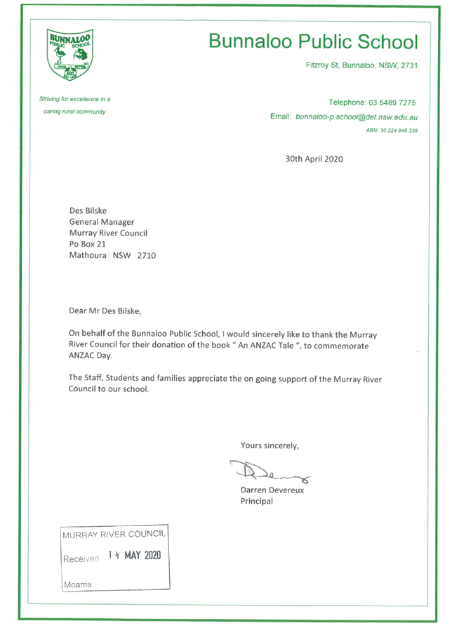
|
MURRAY RIVER
COUNCIL Ordinary Council Meeting Agenda
|
26 May 2020
|
|
MURRAY RIVER
COUNCIL Ordinary Council Meeting Agenda
|
26 May 2020
|
|
MURRAY RIVER COUNCIL Ordinary
Council Meeting Agenda
|
26 May 2020
|
|
MURRAY RIVER
COUNCIL Ordinary Council Meeting Agenda
|
26 May 2020
|
|
MURRAY RIVER COUNCIL Ordinary
Council Meeting Agenda
|
26 May 2020
|
|
MURRAY RIVER COUNCIL Ordinary
Council Meeting Agenda
|
26 May 2020
|

8.6 Sundry
Delegates Report
8.6.1 Sundry
Delegates Report
File
Number: -
Author: Kerri
Keogh, Manager Office of the General Manager
Authoriser: Des
Bilske, General Manager
|
Recommendation
That the Sundry Delegates Report of
the Mayor and Councillors for the period 28 April 2020 to 25 May 2020 be received and the information noted by the Council; and
reasonable out of pocket expenses be met by Council.
|
Discussion
The Mayor, Councillor Chris Bilkey reported on his
attendance at the following meetings and functions:
· 28 Apr:
Councillor Pre-Council Meeting Briefing & Public Forum – Moama
· 28 Apr:
Ordinary Meeting of Council – Moama
· 29 Apr:
Phone Interview with Radio Edge FM
· 29 Apr:
MRC Community Input Briefing Session with RightLane Consulting RE: Virtual Town
Halls – via Zoom
· 30 Apr:
MRC Community Input Virtual Town Hall Meetings x 2 – via Zoom
· 4 May:
Teleconference with NSW Governor, Margaret Beazley
· 5 May:
MRC Community Input Network Consultation Business & Tourism Meeting –
via Zoom
· 6 May:
Councillor Online Meeting/Teleconference
· 7
May: RDA Murray, Murray Regional Leaders Meeting –
via Zoom
· 8 May:
MRC Community Input Network Consultation Community Groups Meeting – via
Zoom
· 8 May:
RAMJO Transport Sub-Committee Meeting – via Zoom
· 12 May:
MDBA Lower Lakes Independent Science Review Webinar
· 12 May:
Councillor Workshop on Rates Harmonisation
· 13 May:
RAMJO Board Meeting – via Zoom
· 14 May:
Councillor In-Camera Session
· 14 May:
RAMJO/MDA Catch Up – via Zoom
· 19 May:
Councillor Pre-Council Meeting Briefing – Moama
· 19 May:
Extraordinary Meeting of Council – Moama
· 20 May:
Performance Review of General Manager
· 20 May:
C4EM Ageing Well in Echuca Moama – via Zoom
The
Deputy Mayor, Councillor Alan Mathers reported on his attendance at the
following meetings and functions:
· 28 Apr:
Councillor Pre-Council Meeting Briefing & Public Forum – via MS Teams
· 28 Apr:
Ordinary Meeting of Council – Via MS Teams
· 6 May:
Councillor Online Meeting/Teleconference
· 12 May:
MDBA Lower Lakes Independent Science Review Webinar
· 12 May:
Councillor Workshop on Rates Harmonisation – via MS Teams
· 14 May:
Councillor In-Camera Session – via MS Teams
· 15 May:
MGRS Board Meeting – via MS Teams
· 19 May:
Councillor Pre-Council Meeting Briefing – via MS Teams
· 19 May:
Extraordinary Meeting of Council – via MS Teams
· 20 May:
Performance Review of General Manager
· 21 May:
MRSG Keelty Report Webinar
Councillor
Tony Aquino reported on his attendance at
the following meetings and functions:
· 28 Apr:
Councillor Pre-Council Meeting Briefing & Public Forum – Moama
· 28 Apr:
Ordinary Meeting of Council – Moama
Councillor
Gen Campbell reported on her attendance at
the following meetings and functions:
· 28 Apr:
Councillor Pre-Council Meeting Briefing & Public Forum – Moama
· 28 Apr:
Ordinary Meeting of Council – Moama
Councillor
Nikki Cohen reported on her attendance at
the following meetings and functions:
· 28 Apr:
Councillor Pre-Council Meeting Briefing & Public Forum – Moama
· 28 Apr:
Ordinary Meeting of Council – Moama
· 12 May:
Councillor Workshop on Rates Harmonisation
· 14 May:
Councillor In-Camera Session – via MS Teams
· 19 May:
Councillor Pre-Council Meeting Briefing – via MS Teams
· 19 May:
Extraordinary Meeting of Council – via MS Teams
Councillor
Ann Crowe reported on her attendance at
the following meetings and functions:
· 28 Apr:
Councillor Pre-Council Meeting Briefing & Public Forum – via MS Teams
· 28 Apr:
Ordinary Meeting of Council – via MS Teams
· 30 Apr:
MRC Community Input Virtual Town Hall Meeting – via Zoom
· 6 May:
Councillor Online Meeting/Teleconference
· 7 May:
Murray River Council Community Grants Assessment Panel Meeting – via MS
Teams
· 12 May:
Councillor Workshop on Rates Harmonisation – via MS Teams
· 14 May:
LGNSW Chairing & Effective Meeting Procedures for Councillors Webcast
· 19 May:
Councillor Pre-Council Meeting Briefing – via MS Teams
· 19 May:
Extraordinary Meeting of Council – via MS Teams
Councillor
Neil Gorey reported on his attendance at
the following meetings and functions:
· 28 Apr:
Councillor Pre-Council Meeting Briefing & Public Forum – via MS Teams
· 28 Apr:
Ordinary Meeting of Council – via MS Teams
·
19 May: Councillor Pre-Council Meeting Briefing
– Moama
·
19 May: Extraordinary Meeting of Council - Moama
Councillor
Thomas Weyrich reported on his attendance
at the following meetings and functions:
· 28 Apr:
Councillor Pre-Council Meeting Briefing & Public Forum – Moama
· 28 Apr:
Ordinary Meeting of Council – Moama
Councillor
Geoff Wise reported on his attendance at
the following meetings and functions:
· 28 Apr:
Councillor Pre-Council Meeting Briefing & Public Forum – Moama
· 28 Apr:
Ordinary Meeting of Council – Moama
· 7 May:
Murray River Council Community Grants Assessment Panel Meeting
· 12 May:
Councillor Workshop on Rates Harmonisation
· 14 May:
Councillor In-Camera Session – Moama
· 19 May:
Councillor Pre-Council Meeting Briefing – Moama
· 19 May:
Extraordinary Meeting of Council – Moama
Attachments
Nil
10 Confidential
Matters
|
Recommendation
That Council considers the confidential report(s) listed
below in a meeting closed to the public in accordance with Section 10A(2) of
the Local Government Act 1993:
10.1 Economic
Development & Tourism Business Unit - Monthly Report
This matter is considered to be confidential under Section
10A(2) - c, d(i) and d(ii) of the Local Government Act, and the Council is
satisfied that discussion of this matter in an open meeting would, on
balance, be contrary to the public interest as it deals with information that
would, if disclosed, confer a commercial advantage on a person with whom the
Council is conducting (or proposes to conduct) business, commercial
information of a confidential nature that would, if disclosed prejudice the
commercial position of the person who supplied it and information that would,
if disclosed, confer a commercial advantage on a competitor of the council.
10.2 Moama Business
Park Expansion
This matter is considered to be confidential under Section
10A(2) - c, d(i) and d(ii) of the Local Government Act, and the Council is
satisfied that discussion of this matter in an open meeting would, on
balance, be contrary to the public interest as it deals with information that
would, if disclosed, confer a commercial advantage on a person with whom the
Council is conducting (or proposes to conduct) business, commercial
information of a confidential nature that would, if disclosed prejudice the
commercial position of the person who supplied it and information that would,
if disclosed, confer a commercial advantage on a competitor of the council.
10.3 Contract C1918 -
Water Meter Replacement & Automatic Meter Reading Network - Contract
Variation
This matter is considered to be confidential under Section
10A(2) - c of the Local Government Act, and the Council is satisfied that
discussion of this matter in an open meeting would, on balance, be contrary
to the public interest as it deals with information that would, if disclosed,
confer a commercial advantage on a person with whom the Council is conducting
(or proposes to conduct) business.
10.4 C2003 Request
for Tender - Waste Kerbside Collection & Associated Processing Services
This matter is considered to be confidential under Section
10A(2) - c of the Local Government Act, and the Council is satisfied that
discussion of this matter in an open meeting would, on balance, be contrary
to the public interest as it deals with information that would, if disclosed,
confer a commercial advantage on a person with whom the Council is conducting
(or proposes to conduct) business.
|