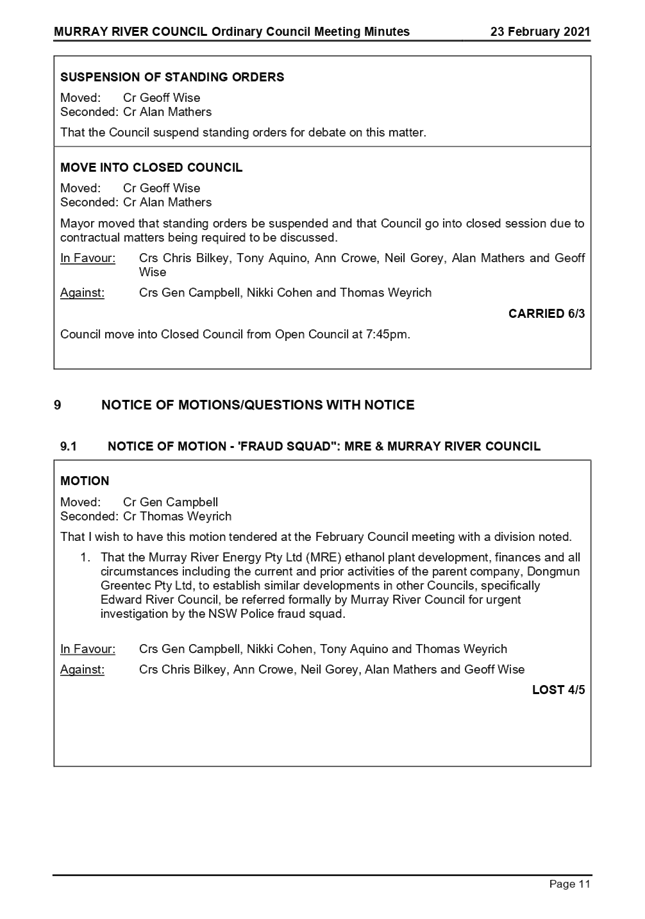
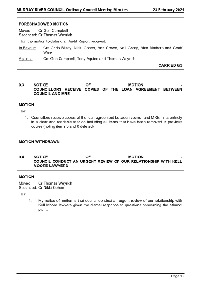
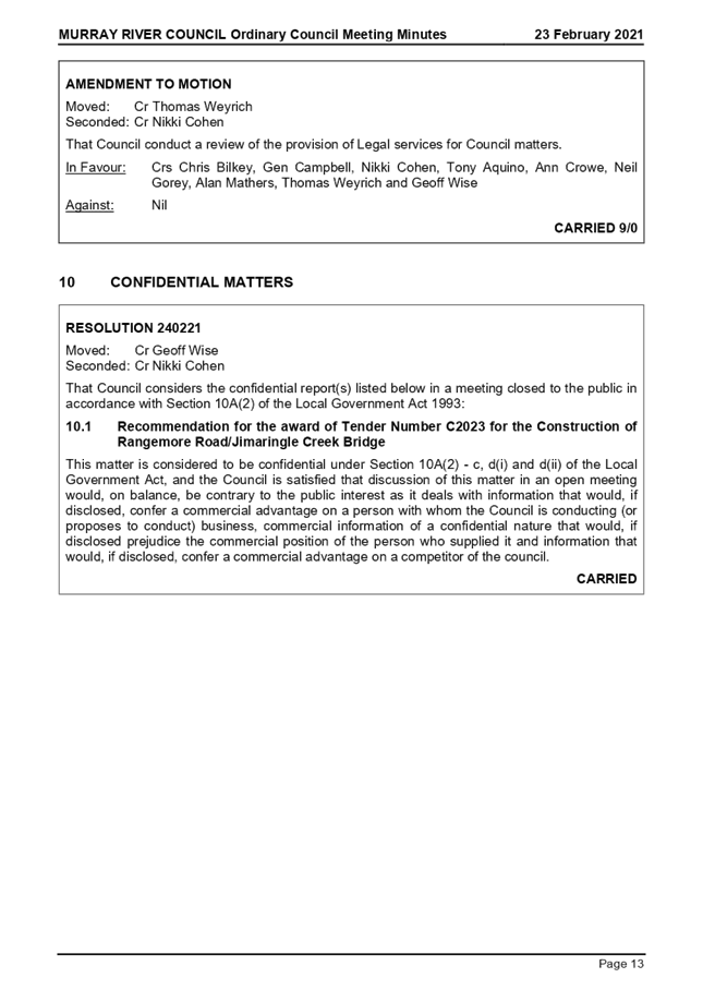
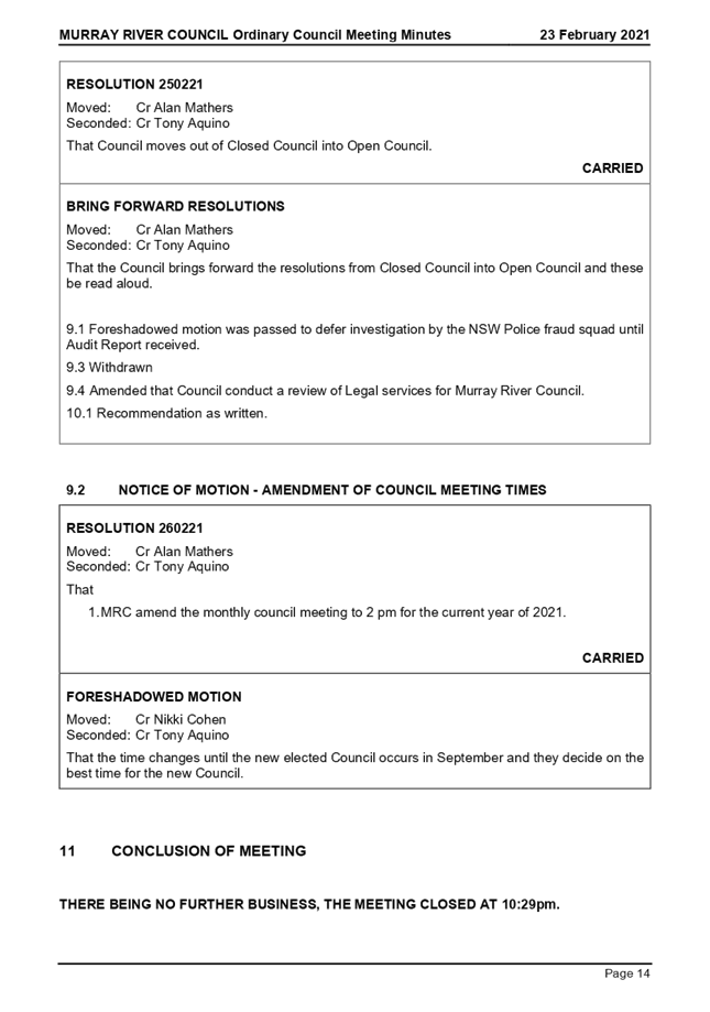
|
|
|
AGENDA
Ordinary Council Meeting
Tuesday, 23 March 2021
|
|
I hereby give notice that an Ordinary Meeting of
Murray River Council will be held on:
|
|
Date:
|
Tuesday, 23 March 2021
|
|
Time:
|
2:00pm
|
|
Location:
|
Council Chambers
Moama Administration Office
52 Perricoota Road, Moama
|
|
Terry Dodds
Chief Executive Officer
|
4 Confirmation
of Minutes
4.1 Confirmation
of Minutes - Ordinary Meeting of Council 19 January 2021
File
Number: -
Author: Lindy
Leyonhjelm, Executive Assistant
Authoriser: Terry
Dodds, Chief Executive Officer
|
Recommendation
That the minutes of the Ordinary Meeting of Murray River
Council held on 23 February 2021 be confirmed as a true and correct record.
|
Discussion
Murray River Council held its Ordinary Meeting of Council on
Tuesday 23 February 2021, commencing at 6:00 pm in the Council Chambers, Moama
Administration Office, 52 Perricoota Road, Moama.
A copy of the draft minutes is attached for ratification by
the Council at this meeting.
Attachments
1. Minutes_Ordinary
Meeting of Council_23 Feb 2021 ⇩ 
|
MURRAY RIVER COUNCIL Ordinary
Council Meeting Agenda
|
23 March 2021
|
9 Reports
to Council
9.1 Chief
Executive Officers Report and Supplementary Matters
9.1.1 Resolutions of the Council -
Resolution Tracker & InfoCouncil Action Reports
File
Number: -
Author: Lindy
Leyonhjelm, Executive Assistant
Authoriser: Terry
Dodds, Chief Executive Officer
|
Recommendation
That the Council
receives and notes the status of previous resolutions of Council (in open and
closed Council) contained in the Resolution Tracker Reports.
|
Background
In September 2018 a
manual Resolution Tracker was introduced as part of the General
Manager’s report to each Council meeting to allow Councillors to review
the current status (actions by Council’s officers) of their decisions
(resolutions).
All resolutions within the manual Resolution Tracker have been
completed by Council’s officers and will be archived. Subsequently, the
manual Resolution Tracker has been superseded by the InfoCouncil Action Report.
In November 2018, Council introduced a software program
called InfoCouncil. Resolutions of the Council that require action/s after each
Council Meeting are automatically generated in InfoCouncil to the relevant
Council officer for their action and comment.
Discussion
The Resolution Tracker Open Report (Attachment 1) and
the Resolution Tracker Closed Action Report (Attachment 2) contain
‘active’ resolutions respectively from open and closed meetings of
the Council held since November 2018 that require action by Council’s
officers.
Comments for the action are shown below each active
resolution of the Council. Resolutions that are reported by Council’s
officers as complete will drop off the ‘active’ list.
Strategic Implications
5 - Strategic Theme 5: Leadership and Governance
5.1 - An effective, efficient and progressive Council that
provides leadership to the community
5.1.1 - Council decision making takes into account the needs
and priorities of our local communities and the longer term social, cultural,
economic and environmental viability and sustainability of our region
Budgetary Implications
Nil.
Policy Implications
Nil.
Legislative Implications
Nil.
Risk Analysis
· What
can happen?
Council’s officers do not
action the resolutions of the Council.
· How
can it happen?
Resolutions from Council
Meetings not being recorded in a systematic fashion.
· What
are the consequences of the event happening?
Actions, because of the
resolutions of the Council, not being completed in a timely manner or at all.
· What
is the likelihood of the event happening?
Low.
· Adequacy
of existing controls?
Use of the report and minute
system, InfoCouncil, which automatically forwards actions (as a result of the
resolutions of the Council) from Council Meetings to the relevant Council
officer (report writer) after the completion of the minutes of a Council
Meeting. A report can then be generated on the status of incomplete/outstanding
actions.
· Treatment
options to mitigate the risk?
Due diligence undertaken by
Council’s officers (administration and report writers).
Conclusion
The Resolution Tracker and Action Reports are presented to
Councillors for information.
Attachments
1. RESOLUTION
TRACKER - OPEN_ 23 MAR 2021 ⇩ 
2. RESOLUTION
TRACKER - CLOSED_23 MAR 2021 ⇩ 
|
MURRAY RIVER COUNCIL Ordinary
Council Meeting Agenda
|
23 March 2021
|
|
MURRAY
RIVER COUNCIL Ordinary Council Meeting Agenda
|
23 March 2021
|
9.1.2 2021 ANZAC
Day Services
File
Number: -
Author: Lindy
Leyonhjelm, Executive Assistant
Authoriser: Terry
Dodds, Chief Executive Officer
|
Recommendation
That the Mayor, or his representative, attends the ANZAC
Day Services in the towns of Barham/Koondrook, Mathoura, Moama, Moulamein,
Piangil/Tooleybuc, Wakool and Echuca (no formal invitation supplied as yet)
on Sunday 25 April 2021, and a lay a wreath on behalf of the Murray River
Council community.
|
Background
Anzac Day, 25 April, is one of Australia’s most
important national occasions. It marks the anniversary of the first major
military action fought by Australian and New Zealand forces during the First
World War. Australians recognise 25 April as a day of national remembrance,
which takes two forms. Commemorative services are held across the nation at
dawn – the time of the original landing, while later in the day, former
servicemen and servicewomen meet to take part in marches through the country’s
major cities and in many smaller centres. Commemorative ceremonies are more
formal and are held at war memorials around the country. In these ways, Anzac
Day is a time at which Australians reflect on the many different meanings of
war.
It has been common practice for a Council representative,
namely the Mayor and Councillors, to attend each of the local ANZAC Day
Services within the Council area and lay a wreath on behalf of the Murray River
Council community in memory of returned and fallen servicemen and servicewomen.
Discussion
ANZAC Day falls on Sunday 25 April this year. Council has
been advised of the following services within the Murray River Council area and
surrounds:
MOAMA (organised by Moama RSL Sub Branch):
· Dawn Service* (5:55AM) at Moama Cenotaph, Kerrabee
Soundshell, immediately followed by a Gunfire Breakfast at Moama RSL
· 9AM Commemorative Service* at Moama Cenotaph,
Kerrabee Soundshell – Councillor requested to attend and lay a wreath on
behalf of Murray River Council
Although contacted by Council prior to this report being
presented, advice has not been received by the organisers in relation to the
ANZAC Day services in all towns, with the exception of Moama. These details
will need to be provided to Councillors at a later date, but generally are as
follows:
MATHOURA (organised by Mathoura RSL Sub Branch):
· Dawn Service (6AM) at the Mathoura Cenotaph, Soldier’s Memorial Gardens,
followed by breakfast at the Soldier’s Memorial Hall
· 11AM Commemorative Service* - (site to be confirmed)
afterwards a march to
the Soldiers Memorial
Gardens for a further short wreath laying ceremony, followed by a luncheon at
the Mathoura Bowling Club.
PIANGIL & TOOLEYBUC (organised by Piangil RSL Sub
Branch):
· 9:30AM Commemorative Service* at Piangil Community
Hall
WAKOOL:
· 3:00PM Commemorative Service* at Wakool Memorial
Hall, followed by a March to the Wakool Cenotaph for a short wreath laying
ceremony
ECHUCA (organised by Echuca RSL Sub-Branch):
· 11AM
Commemorative Service* at Echuca War Memorial, Civic Centre Gardens,
Hare St
BARHAM (organised by Barham RSL Sub Branch):
· Dawn
Service (6AM) at Barham Cenotaph (Cnr Murray & Noorong Sts), followed by a Breakfast
at cluBarham
· Commemorative
Service & March – TBA, depending on Victoria rules regarding ANZAC
Day services.
MOULAMEIN:
· Dawn
Service (6:15AM) at The Triangle Park (Brougham St)
· 10:45AM
March (assemble at Business Centre by 10.30am)
· 11AM
Commemorative Service at The Triangle Park (Brougham St)
In addition to Council representation at the above
services, Council will also be donating books relating to the war/ANZAC Day to
all school libraries in the Council area.
Strategic Implications
5 - Strategic Theme 5: Leadership and Governance
5.1 - An effective, efficient and progressive Council that
provides leadership to the community
5.1.3 - Build and maintain strong partnerships and
relationships with all stakeholders especially our local communities, while
also building effective working relationships with our neighbouring councils
Budgetary Implications
· Cost of
wreaths x 7 @ approx. $70 per wreath.
· The Moama
RSL Sub-Branch has requested Council to supply access to power and seating for 500
for the ANZAC Day services at the Moama Cenotaph.
· Purchase of
books x 11 (8 x Primary; 3 x Secondary) for donation to schools = up to $200.
Policy Implications
Nil.
Legislative Implications
Risk Analysis
· What
can happen?
· No
Council representation at ANZAC Day services in the Council area.
· How
can it happen?
· No
invitations are received by Council from the organisers of an ANZAC Day service
OR Councillors are unable to attend the ANZAC Day services in the Council area.
· What
are the consequences of the event happening?
· No
Council representation at an ANZAC Day service due to Council not formally
being advised by the organisers of an ANZAC Day service.
· What
is the likelihood of the event happening?
· Medium.
· Adequacy
of existing controls?
· High.
· Treatment
options to mitigate the risk?
· Advise
organisers of ANZAC Day services in the Council area that Council requires
formal advice (through letter or email) of an ANZAC Day service to enable
appropriate representation at same.
Conclusion
ANZAC Day falls on Sunday 25 April this year. There are a
number of Dawn and Commemorative Services being held throughout the Murray
River Council area. The Mayor, or a representative, have been invited to attend
Commemoration Services and lay a wreath on behalf of the citizens of Murray
River Council.
Attachments
Nil
9.1.3 MRC
Delegates for Murray River Council (Southern) Liquor Accord
File
Number: -
Author: Lindy
Leyonhjelm, Executive Assistant
Authoriser: Terry
Dodds, Chief Executive Officer
|
Recommendation
That Council appoint Cr Nikki Cohen a delegate and Cr Gen
Campbell and alternate delegate for 2021 meetings of Murray River Council
(Southern) Liquor Accord committee.
|
Background
In NSW Liquor accords are voluntary
industry-based partnerships working in local communities to introduce practical
solutions to liquor-related problems. They reach agreements on ways to improve
the operation of licensed venues so that entertainment venues and precincts are
safe and enjoyable.
Most liquor accords include members
from the local business community, local councils, police, government
departments and other community organisations.
Discussion
The purpose of this report is to approve delegates to attend
the Murray River Council (Southern) Liquor Accord meetings that are held
quarterly.
Cr Nikki Cohen has agreed to attend the next meeting on
behalf of Murray River Council, which was held on Tuesday 16 March at 10am,
prior to Council meeting for approval. Cr Gen Campbell has agreed to continue
as an alternative delegate for the Liquor Accord meetings.
The restrictions imposed by COVID-19 has meant that several
committees have postponed general meetings.
Strategic Implications
5 - Strategic Theme 5: Leadership and Governance
5.2 - Engaged community leadership
5.2.1 - Council and community members actively lead and
collaborate to bring the Community Strategic Plan and Vision to life;
demonstrating innovative solutions, future thinking and forward planning
Budgetary Implications
Nil.
Policy Implications
Nil.
Legislative Implications
Risk Analysis
· What
can happen?
N/A
· How
can it happen?
N/A
· What
are the consequences of the event happening?
N/A
· What
is the likelihood of the event happening?
N/A
· Adequacy
of existing controls?
N/A
· Treatment
options to mitigate the risk?
N/A
Conclusion
The Murray River Council (Southern Region) Liquor Accord has
requested for Council attendance at these meetings.
Cr Cohen has requested to attend with Cr Gen Campbell
requesting to continue on as alternative delegate for attendance to the
meetings.
Council should now move to carry Cr Cohen as delegate and Cr
Campbell as alternate delegate.
Attachments
Nil
9.2 Director
Shared Services Report and Supplementary Matters
9.2.1 Building Better Regions Grant
Funding Program - Applying 2020-21 Budgeted Council Contributions Towards Grant
Application
File
Number: -
Author: Kris
Kershaw, Manager Finance
Authoriser: Terry
Dodds, Chief Executive Officer
|
Recommendation
That Council
1. Acknowledge and
support Council’s application submission towards the Building Better
Regions Fund – Round 5 grant application of $2.625 million total
project budget.
2. Approve the
carry-on of the Council contribution, as identified below, from the 2020/21
financial year budget into the 2021/22 financial year budget:
a) Horseshoe
lagoon $451,270
b) Riverside
caravan park retaining wall $200,000
c) Beach
amenities block $100,000
|
Background
Within the 2020/21 financial year budget, Council has allocated
$751,270 towards the three projects as follows:
a) Horseshoe
Lagoon $451,270
b) Riverside
Caravan Park retaining wall $200,000
c) Beach
amenities block $100,000
The total cost of the three projects is $1,502,541, of which
50% is funded under the Regional Growth Fund program and the other 50% funded
by Council contribution (as above).
The Council contribution of $751,270 contributed towards
Council having an overall budget deficit of ($1,209,938) for the 2020/21
financial year. This contribution was resolved as part of the June 2020 Council
resolution number 170620 to adopt the 2020/21 Operational Plan.
Council has now applied for funding through Building Better
Regions Fund Round 5 (BBRF Rd 5) and submissions closed 5 March 2021. Please
note that project works must be completed by December 2023. The funding allows
for Council to apply for up to 75% of Commonwealth funding for the three
projects listed above – projects that allow Council to achieve outcomes
under the Meninya Street South
Masterplan. The funding allows for the projects to be completed over a
two and a half-year period: 2021/22 to 2023/24 financial years. This
application will also mean that Council can defer its contribution of $751,270
from the 2020/21 current year budget and carry the total contribution into the
2021/22 year budget.
Discussion
The purpose of this report is to inform Council that a grant
funding opportunity has presented it whereby the three projects of the
Horseshoe Lagoon, Riverside Caravan Park retaining wall and the beach amenities
block can be incorporated into a new grant application, which would allow
Council to complete more of the works with the same dollar contribution from
Council. Also, the Council contribution would not be needed until the 2021/22
financial year, resulting in the $751,270 in the current 2020/21 financial year
budget being a carry-on into the 2021/22 financial year budget. This would
assist with removing the 2020/21 budgeted deficit as the $751,270 contribution
is removed from the budget this financial year and thereby turning the current
deficit of ($511,665) into a small surplus of $239,605 (pending any further
amendments in future quarter budget reviews).
The grant funding in question is the Building Better Regions
– Round 5 (BBRF Rd 5). The funding allows for Council to apply for up to
75% total Commonwealth grant funding. Council can utilise the Regional Growth
Fund already granted to Council as part of the overall project cost, but total
Commonwealth grant funding cannot be more than 75% in total, including the
Regional Growth Fund amount. NSW grant funding can be utilised and is treated
as Council contribution for the purpose of the application.
The proposed funding application will be for $2.625 million
total, including project management cost of $125,000, which will be a Council
in-kind contribution. The costing and design works are currently being
developed, but the project will allow Council to further implement the Meninya Street South Masterplan, as
adopted by Council at the October 2019 meeting (resolution number 131019).
Council contribution under this funding application is
$625,000 (25% of $2.5 million less the in-kind contribution) plus $125,000
in-kind contribution, which give a total of $750,000.
The proposed funding arrangement, if successful, would be as
follows:
|
Funding Source
|
Funding Body
|
Amount
|
|
Grant – Building
Better Regions Fund
|
Commonwealth
|
$1,123,999
|
|
Grant – Regional
Growth Fund
|
Commonwealth
|
$751,271
|
|
Grant – Community
Building Partnerships Fund *
|
NSW State
|
$50,000
|
|
Grant – Crown
Reserves Improvement Fund *
|
NSW State
|
$86,363
|
|
Council Contribution *
|
Council
|
$488,367
|
|
Council Contribution
– In Kind for Project Management
|
Council
|
$125,000
|
|
Total Project Costs
|
|
$2,625,000
|
* Council contribution can be made up of NSW Grant funding
as well as Council own source funding. Two NSW grants that Council has already
received have been identified as been contributions to the project as Council
contribution.
The application outcome is not expected to be known until
around June or July 2021. The project will not commence until sometime July
2021 onwards. It is on this basis that the current budgeted Council
contribution of $751,270 can be a carry-on, or re-vote, from the 2020/21 to the
2021/22 financial year. For now, it is proposed to carry on the full $751,270
until the application is confirmed as being successful. The table above shows
Council actual own source contribution would be $488,367 plus the $125,000
in-kind, a total of $613,367. Any saving between the $751,270 and final
contribution by Council can be dealt with as part of the 1st quarter
budget review (September 2021).
The detailed project designs and costing details are being
finalised on expectation that detailed costings will be requested by the
funding body. For now, Council was only required to submit a funding
application based on a total project cost, with a funding breakdown over
financial years (years 2021/22 to 2023/24). Council will be kept informed of
this application process over the coming months via the monthly Grants Update
report.
Strategic Implications
5 - Strategic Theme 5: Leadership and Governance
5.1 - An effective, efficient and progressive Council that
provides leadership to the community
5.1.2 - Council acts in a financially responsible manner to
ensure delivery of safe and sustainable services to the community
Budgetary Implications
2020/21 budget saving of $751,270 Council contribution. This
does result in the amount being a carry-on into the 2021/22 financial year
(re-voted). The carry-on of the $751,270 budget into future year 2021/22 budget
also allows for Council to eliminate the current budget deficit of ($511,665)
and show a small surplus of $239,605 (pending any future 2020/21 year budget review
amendments).
Policy Implications
Nil.
Legislative Implications
Risk Analysis
· What
can happen?
Further deterioration of retaining
wall at Riverside Caravan Park
· How
can it happen?
By not renewing/ upgrading
existing wall to a standard that reduces or eliminates further risk of failure.
· What
are the consequences of the event happening?
Restrictions placed on public
access to the parts of the land and river adjoining the retaining wall.
· What
is the likelihood of the event happening?
High. Retaining
wall has already failed in areas.
· Adequacy
of existing controls?
Adequate for now. Measures are in
place to manage the risks for the short-term, but further delays in renewal/
upgrade of the wall will result in possible further failures, exposing Council
to greater asset and possible environmental risk (land slips into the river),
as well as even result in reputation risk.
· Treatment
options to mitigate the risk?
Apply for grant funding as it
becomes available to assist with the overall cost to renew/upgrade the
retaining wall.
Conclusion
Council has an opportunity to complete more project work
using the same Council contribution of $751,270. The carry-on of the $751,270
budget into future year budget also allows for Council to eliminate the current
budget deficit of ($511,665) and show a small surplus of $239,605 (pending any
future 2020/21 year budget review amendments).
Attachments
Nil
9.2.2 FINANCIAL
STATEMENTS AND INVESTMENTS AS AT 28 FEBRUARY 2021
File
Number: -
Author: Abbas
Mehr, Financial Accountant
Authoriser: Terry
Dodds, Chief Executive Officer
|
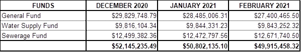
Recommendation
That
1. The Officer’s report on Council’s
Financial Statements, Bank Reconciliations and Investments as at 28th
February 2021 be received and noted.
2. The report detailing the Council’s
Position of $ 49,915,458.32 as at 28th February 2021 is received.
3. The report detailing Council’s Investment balance
of $ 49,045,567.91as at 28th February, 2021 received.
|
BACKGROUND
Discussion
REPORT – BANK RECONCILIATION
Shown below are the Financial Statements, Bank Reconciliations
and Investments for the period ending 28th February 2021.
STATEMENT OF BANK BALANCES AS AT 28TH FEBRUARY
2021 OF COUNCIL’S COMBINED ACCOUNTS

INTERNAL CASH BOOK BALANCES
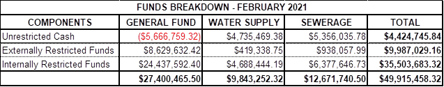
OVERDRAFT LIMITS: Bank Overdraft - $ 650,000.00
I hereby certify that the Cashbook of the various funds of
Council has been reconciled, with the appropriate Pass Sheets as 28th
February 2021.
Terry Dodds
Chief Executive Officer / Acting Director Shared Services
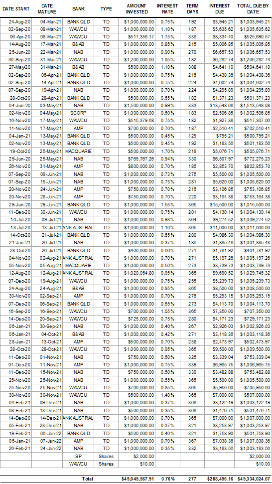
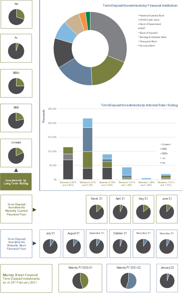
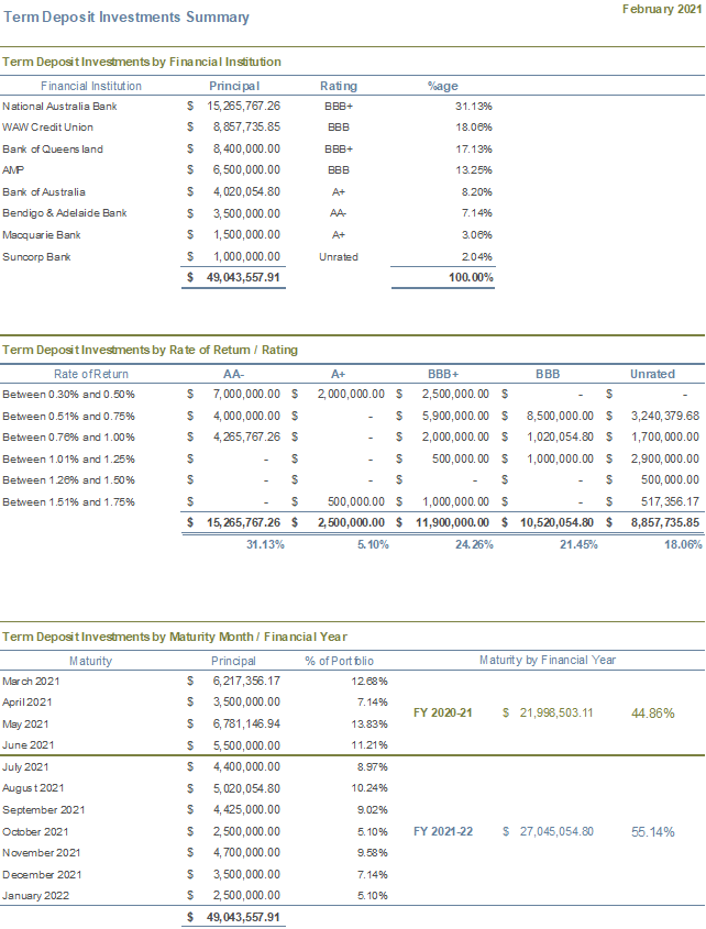
REPORT INVESTMENTS AS AT 28TH FEBRUARY 2021
As required by Section 212 of the Local Government (General)
Regulation 2005 and Section 625 of the Local Government Act 1993, the details
of Council’s surplus funds invested, totalling $49,045,567.91 are listed
below.
STRATEGIC IMPLICATIONS
5 – Strategic Theme
5: Leadership and Governance
5.1 – An effective,
efficient and progressive Council that provides leadership to the community.
5.1.2 – Council
acts in a financially responsible manner to ensure deliver of safe and
sustainable services to the community.
BUDGETARY IMPLICATIONS
Continual low interest
rates may have a negative impact on the expected interest value.
POLICY IMPLICATIONS
Investments are made in
accordance with the Council’s Investment Policy which was adopted on
the 27 October 2020
LEGISLATIVE
IMPLICATIONS
Section 625 of the Local
Government Act 1993
Regulation 212 of the
Local Government (General) Regulations 2005
Trustees Act 1925 Section
14
RISK ANALYSIS
· What
can happen?
Imprudent
use of council’s financial resources
· How
can it happen?
Not
following investment rules, policies or mandates
· What
are the consequences of the event happening?
Potential
loss of financial resources
· What
is the likelihood of the event happening?
Low
· Adequacy
of existing controls?
Good
· Treatment
options to mitigate the risk?
Responsible
management of financial resources invested in accordance with Council’s
investment policies and mandate.
CONCLUSION
Murray River
Council’s liquidity is in a satisfactory position at 28th
February 2021.
Attachments
Nil
9.2.3 DRAFT
Minutes of the Audit & Risk Committee Meeting held on the 8 February 2021
File
Number: -
Author: Sandra
Gordon, Manager Risk
Authoriser: Terry
Dodds, Chief Executive Officer
|
Recommendation
That the DRAFT Minutes of
the Audit & Risk Committee Meeting held on the 8 February 2021
be
received and the information noted by the Council.
|
Discussion
The Audit and Risk Committee meets a minimum of four (4)
times a year. The most recent meeting was held on the 8 February 2021 and a
copy of those minutes are attached.
Attachments
1. DRAFT
Minutes A& R Committee held 8 February 2021 ⇩
|
MURRAY RIVER COUNCIL Ordinary
Council Meeting Agenda
|
23 March 2021
|
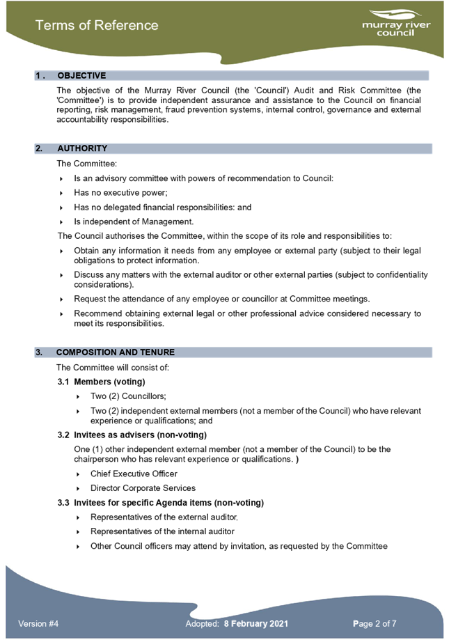
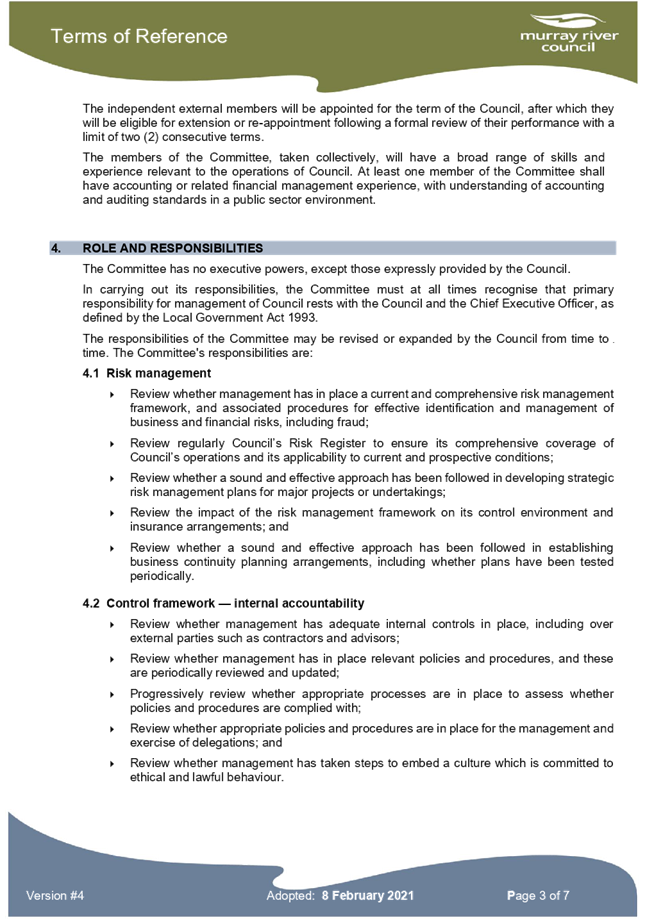
9.2.4 Audit &
Risk Committee - Terms of Reference V#4
File
Number: -
Author: Sandra
Gordon, Manager Risk
Authoriser: Terry
Dodds, Chief Executive Officer
|
Recommendation
That the Audit & Risk
Committee - Terms of Reference V#4 adopted
by the Council.
|
Discussion
Council first adopted the Audit & Risk Committee‘s
Terms of Reference in October 2017 and Version #3 in March 2019.
As outlined in the document, the Terms of Reference should
be reviewed every two (2) years.
At their February 2021 meeting the A&R Committee passed
the following recommendation.
RECOMMENDATION:
That the Audit & Risk Committee Terms
of Reference, as presented by Frank Crawley, be accepted and a report be prepared
for the March 2021 Council Meeting for adoption by Council.
MOVED:
Frank Crawley SECONDED: Jodie
Morgan CARRIED
Attachments
1. A&RC
- Terms of Reference V#4 ⇩ 
|
MURRAY RIVER COUNCIL Ordinary
Council Meeting Agenda
|
23 March 2021
|
9.3 Director
Operations and Major Projects Report and Supplementary Matters
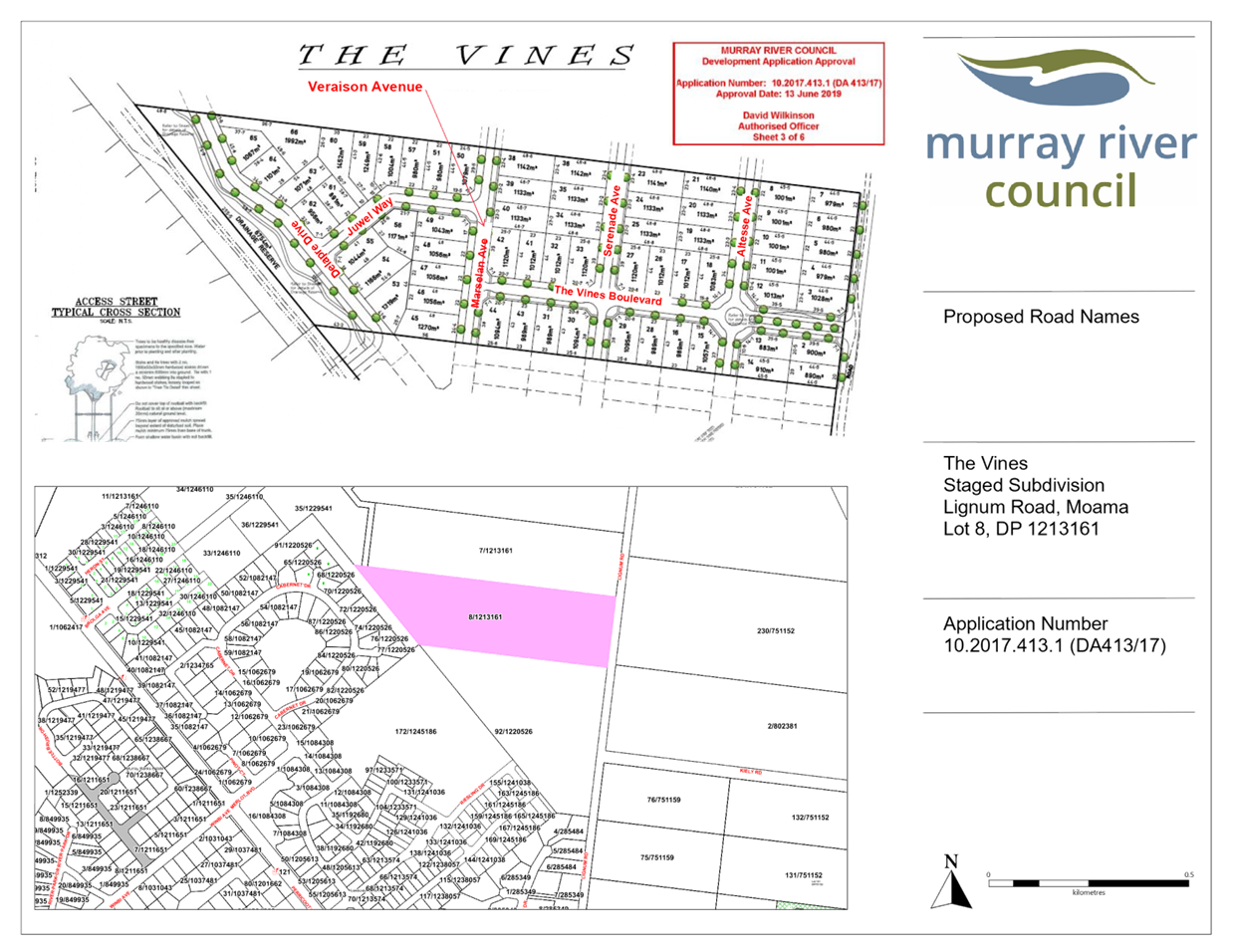
9.3.1 Proposed Road Name, The Vines
Staged Subivision, Lot 8 DP 1213161 Lignum Road Moama
File
Number: -
Author: Rebecca
Ward, Administration Officer
Authoriser: Scott
Barber, Director Operations & Major Projects
|
Recommendation
That Council approve
the road name Veraison Drive within “The Vines” staged
subdivision of Lot 8, DP 1213161, Lignum Road Moama.
|
Background
Council has received a
request from the developers of “The Vines” to name the road within
the staged subdivision of Lot 8, DP 1213161, Lignum Road, Moama.
The previously proposed
road name was Marselan Avenue. At the Ordinary Council meeting held 24 November
2020, Council requested that another name be applied to avoid confusion with
Marsanne Drive in a neighbouring area (Resolution 191120).
Discussion
For the purposes of the
Geographical Names Board NSW Address Policy Council is responsible for
endorsing the authoritative road name of public roads and ensuring they are
approved by the Geographical Names Board and gazetted.
The below suggested name
is based around a vineyard theme and complies with the requirements of the
Geographical Names Board.
· Veraison Drive: “Veraison is a
physiological stage in a grape vines life cycle that is marked by a change in
the appearance and hardness of the grape berry, so the name is keeping with the
grape theme”.
The road location is
shown in Attachment 1.
Strategic Implications
5 - Strategic Theme 5: Leadership and Governance
5.4 - Develop and pursue advocacy on behalf of the community
5.4.1 - Pursue advocacy on key issues of importance to the
community and Council
Budgetary Implications
Nil
Policy Implications
Nil.
Legislative Implications
Roads Act 1993.
Risk Analysis
· What
can happen?
The road remains unnamed.
· How
can it happen?
Road not approved and gazetted.
· What
are the consequences of the event happening?
Difficulty identifying property,
no spatial reference.
· What
is the likelihood of the event happening?
Medium to high
· Adequacy
of existing controls?
Good in that Council staff are
available to carry out the formality of naming and gazetting the public road.
· Treatment
options to mitigate the risk?
Council to pass a resolution to
name the public road.
Conclusion
The proposed public road name complies with the Geographical
Names Board guidelines for the naming of roads and are therefore supported.
Attachments
1. Proposed
Road Name - The Vines Estate, Lignum Road, Moama ⇩ 
|
MURRAY RIVER COUNCIL Ordinary
Council Meeting Agenda
|
23 March 2021
|
9.3.2 Major
Projects Progress Update
File
Number: -
Author: Jan
Donald
Authoriser: Scott
Barber, Director Operations & Major Projects
|
Recommendation
That the Council receives and notes the report on the Major
Projects Progress Update as at 8 March 2021.
|
purpose
To inform elected officials and
the community about the progress of externally and internally funded major infrastructure
projects.
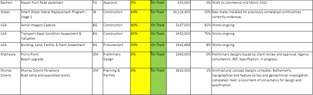
DISCUSSION
Major Projects continue to be delivered with many of the larger
works nearing completion. Council’s reputation amongst funding bodies is very
positive. The organisation is actively searching for external funds and is gaining
a reputation for delivering as promised.
This is important for a State or Federal Government
Department that is managing large and complicated grants programs. Councils
that submit quality applications, provide required reporting, meet payment
milestones and deliver the works on time are very much appreciated and
acknowledged. Murray River Council is well regarded by repeated programs such
as the NSW Stronger Country Communities Fund, which has provided three rounds
of significant funding to this Local Government Area.
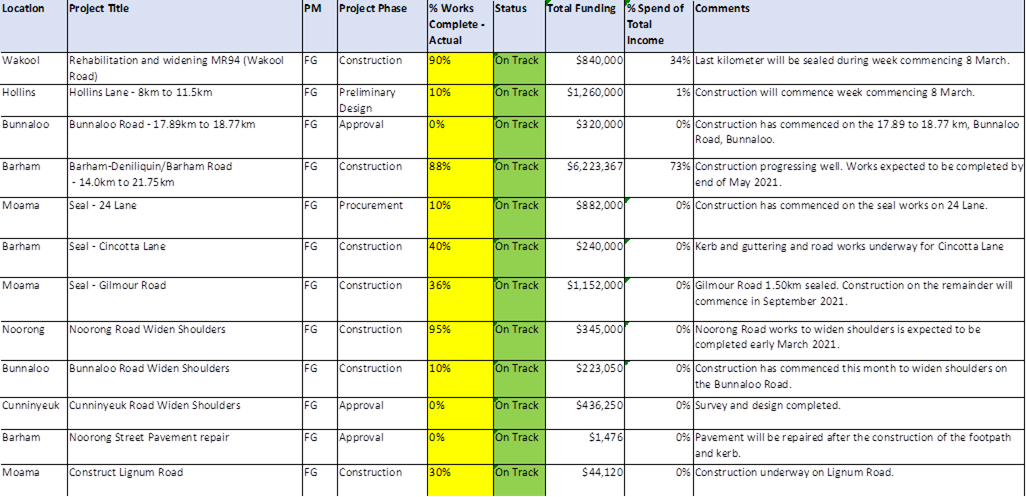
Council is actively working
with funding organisations to use unspent funds to deliver works where
appropriate. For example, this month a variation was approved to place unspent
project funds into a separate entry road for Moama Recreation Reserve Eddy
Oval. This will increase safety within the Moama Administration Office carpark
where traffic enters the Eddy Oval area. Also anticipating a response on a variation
to fund a pedestrian crossing and lighting at Moulamein South Recreation Reserve.
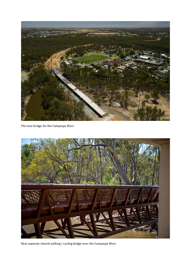
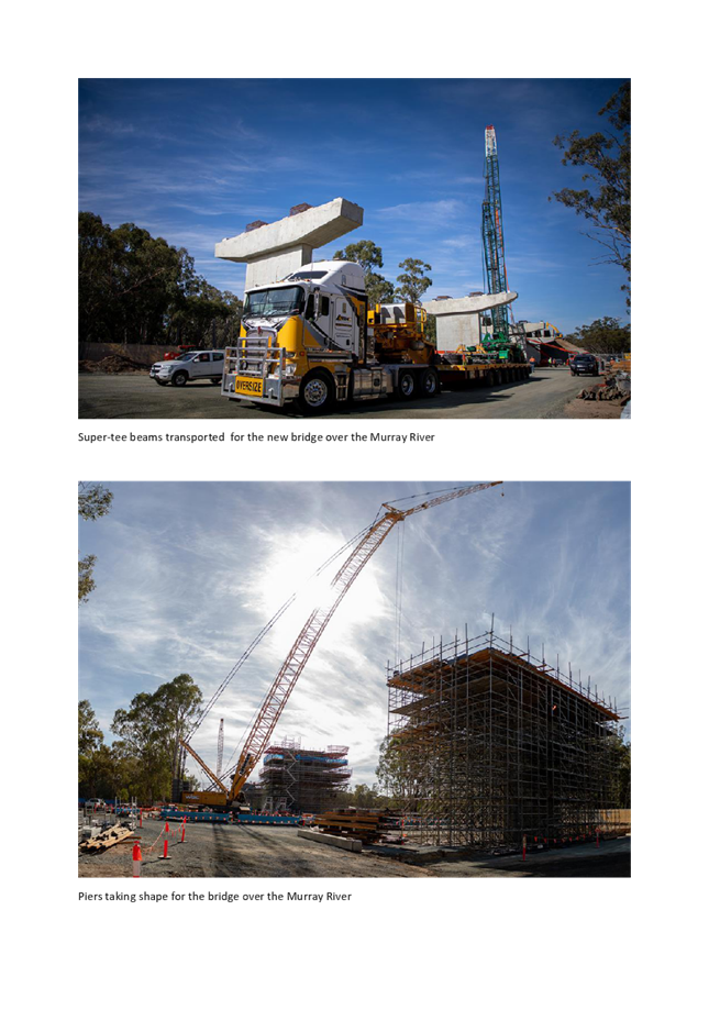
ECHUCA / MOAMA BRIDGE UPDATE
· Completed
all pier works for the Murray River Bridge (Victoria and NSW).
· Precast
concrete Super T beams installed on the Murray River Bridge approach spans in
Victoria with a total of four spans now placed.
· Precast
concrete Super T beams commenced on the Murray River Bridge approach spans in
NSW with three spans placed.
· Completed
the first box girder sections on the main riverbank piers of the Murray River
Bridge in readiness for the installation of travelling form machines that will
complete the remaining box girder sections.
· Completed
all formation earthworks for the Project.
· Continued
installation of stormwater drainage and subsurface drainage lines.
· Commenced
pavement works in Victoria with placement of crushed rock and cement treated
crushed rock layers.
· February
construction update sent to over 11,500 residents, business and digital
subscribers.
· Social media post
of Campaspe River Bridge beam installation.
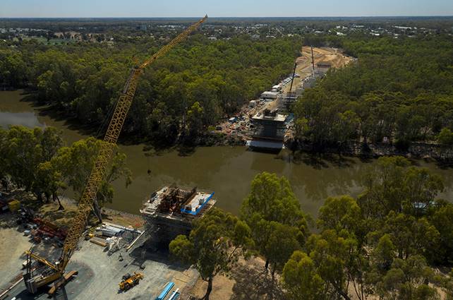
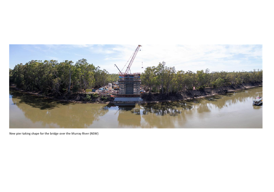
The
new Echuca Moama Bridge looking North to Moama
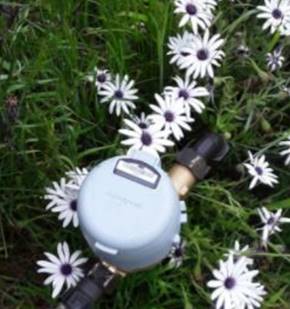
PROJECT HIGHLIGHT REPORT – WATER METER PROJECT
With the
majority of filtered water meters installed across the Council and over 1,000
raw meters installed in Moama, our contractors Taggle have now commenced
installing the remaining raw meters including towns that were previously
unmetered. It is a significant task to locate these buried
connections. The works are expected to be completed by May 2021.
SCF,
SCCF, SHOWGROUNDS & RGF

ROADS, BRIDGES, ASSETS & WATER
|
MURRAY RIVER COUNCIL Ordinary
Council Meeting Agenda
|
23 March 2021
|
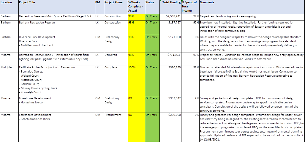
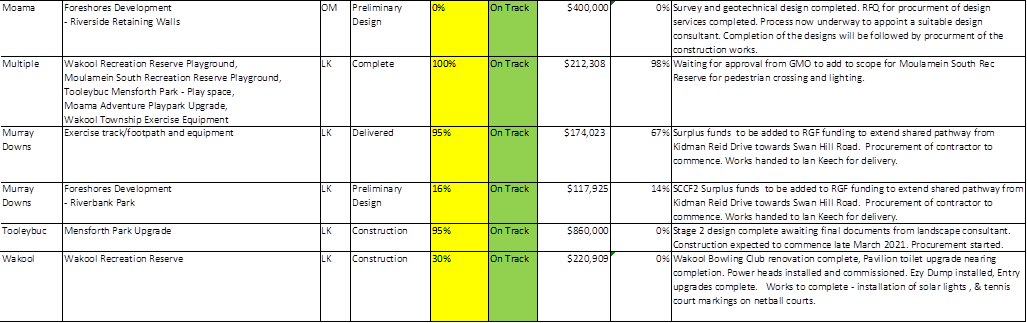
Major
Projects completed during the last 24 months
|
Location
|
Project Title
|
Construction
Complete
|
|
Barham
|
Community Hub – Stage 1
|
July 2020
|
|
Barham
|
Recreation Reserve Skate Park
|
March 2019 *
|
|
Barham
|
Bridge Road Access
|
December 2019
|
|
Barham
|
Riverside Park Development – Pontoon
|
October 2020
|
|
Barham
|
Lawson Pavilion Refurbishment 1-2
|
February 2021
|
|
Mathoura
|
Recreation Reserve Pavilion Ext, Kitchen & Bar
|
May 2019
|
|
Mathoura
|
Picnic Point Development (footbridges)
|
June 2020
|
|
Mathoura
|
Picnic Point Boat Ramp
|
July 2020
|
|
Moama
|
Recreation Reserve Zone 4 Lights / Criterion Track/ Landscape
|
March 2019 *
|
|
Moama
|
New Office Car Park Upgrade
|
December 2019
|
|
Moama
|
Recreation Reserve Road Sealing and Drainage
|
December 2019
|
|
Moama
|
HQ refurbishment Stage 1
|
January 2020
|
|
Moama
|
Rec Reserve Zone 2 – Installation of sports field lighting, car
park upgrade, field extension (Eddy Oval)
|
August 2020
|
|
Moama
|
Rec Reserve Zone 3 – Off Leash Area (due for completion end of
August)
|
August 2020
|
|
Moama
|
Moama Recreation Reserve – Showground Stimulus Funding
|
October 2020
|
|
Moama
|
Business Park (Industrial Estate) Upgrade water pressure pump
|
January 2021
|
|
Moulamein
|
Merran Creek Bridge - Moulamein-Swan Hill Road
|
June 2020
|
|
Moulamein
|
Pre-School
|
October 2020
|
|
Moulamein
|
South Rec Reserve renewal surface and lights and shelter shed / Tennis
courts
|
June 2020
|
|
Tooleybuc
|
Recreation Reserve Irrigation System Upgrade
|
January 2020
|
|
Tooleybuc
|
Foreshores Development - Pontoon
|
November 2019
|
|
Tooleybuc
|
Mensforth Park Footpath and Lighting
|
November 2019
|
|
Tooleybuc
|
Mensforth Park Upgrade
|
March 2020
|
|
Tooleybuc
|
Recreation Reserve Amenities Building
|
October 2020
|
|
Wakool
|
New Toilet Block
|
July 2020
|
|
Wakool
|
Ezy Dump installation – Wakool Recreation Reserve
|
February 2021
|
|
Various
|
Playgrounds – Wakool Rec Reserve, Moulamein South Rec Reserve,
Tooleybuc Mensforth Park, Moama Adventure Playpark, Wakool Township Exercise
Equipment
|
July 2019
|
*
These projects will be removed from the completed projects list next month.
CONCLUSION
Majority of
projects are on track, being delivered and maximising available funds where
appropriate – your feedback on improvements is welcome.
Attachments
1. Echuca
Moama Bridge Photos ⇩
|
MURRAY RIVER COUNCIL Ordinary
Council Meeting Agenda
|
23 March 2021
|
9.3.3 Murray
River Council Local Traffic Committee
File
Number: -
Author: Jan
Donald, Executive Administration Officer
Authoriser: Scott
Barber, Director Operations & Major Projects
|
Recommendation
That Council note the minutes of the Murray River Council
Local Traffic Committee meeting held on Thursday 4 February 2021.
|
Background
The Murray River Council Local Traffic Committee is a
technical review committee that is required to advise Council on traffic
related matters.
Discussion
At the meeting of the Murray River Council Local Traffic
Committee held on Thursday 4 February, the following recommendations were made:
1. Relocate
the 50km signage and update and relocate the compression brake signage on Cobb
Highway to the north side of Keily Road pending confirmation from TfNSW. This
recommendation will be formally brought before Council at a later date.
2. Request
Echuca Moama Transit to cease using Aberdeen Way for school and town bus
services due to resident complaints and road safety concerns. This
recommendation will be formally brought before Council at a later date.
Strategic Implications
1 - Strategic Theme 1: Built/Physical Environment
1.2 - Improve and maintain our road and transport network
1.2.1 - Develop long-term plans for maintenance and
construction of town streets and the rural road network - with priorities
established in conjunction with the community
Budgetary Implications
Nil
Policy Implications
Nil.
Legislative Implications
Risk Analysis
· What
can happen?
Speeding and road safety concerns.
· How
can it happen?
Speeding motorists.
· What
are the consequences of the event happening?
Injury
· What
is the likelihood of the event happening?
Moderate
· Adequacy
of existing controls?
· Treatment
options to mitigate the risk?
Increase NSW Police Highway
Patrols.
Conclusion
The Murray River Council Local Traffic Committee supports
the recommendations as outlined above and seeks Council approval to adopt these
recommendations.
Attachments
1. Local
Traffic Committee Minutes ⇩
|
MURRAY RIVER COUNCIL Ordinary
Council Meeting Agenda
|
23 March 2021
|
9.3.4 Proposed
Road Names - The Range Staged Subdivision - Lot 11, DP 701453 Beer Road, Moama
File
Number: -
Author: Rebecca
Ward, Assets Officer
Authoriser: Scott
Barber, Director Operations & Major Projects
|
Recommendation
That Council approve:
1. The proposed road names within
the staged subdivision of Lot 11, DP 701453, Beer Road Moama as listed within
this report; and
2. The advertisement of these proposed road names
on the Council’s website
|
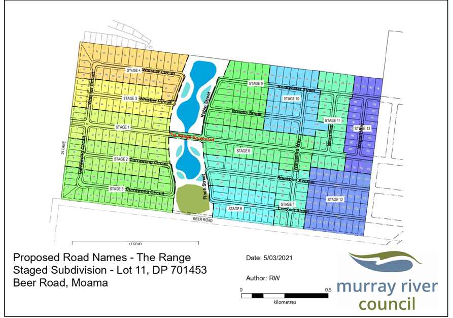
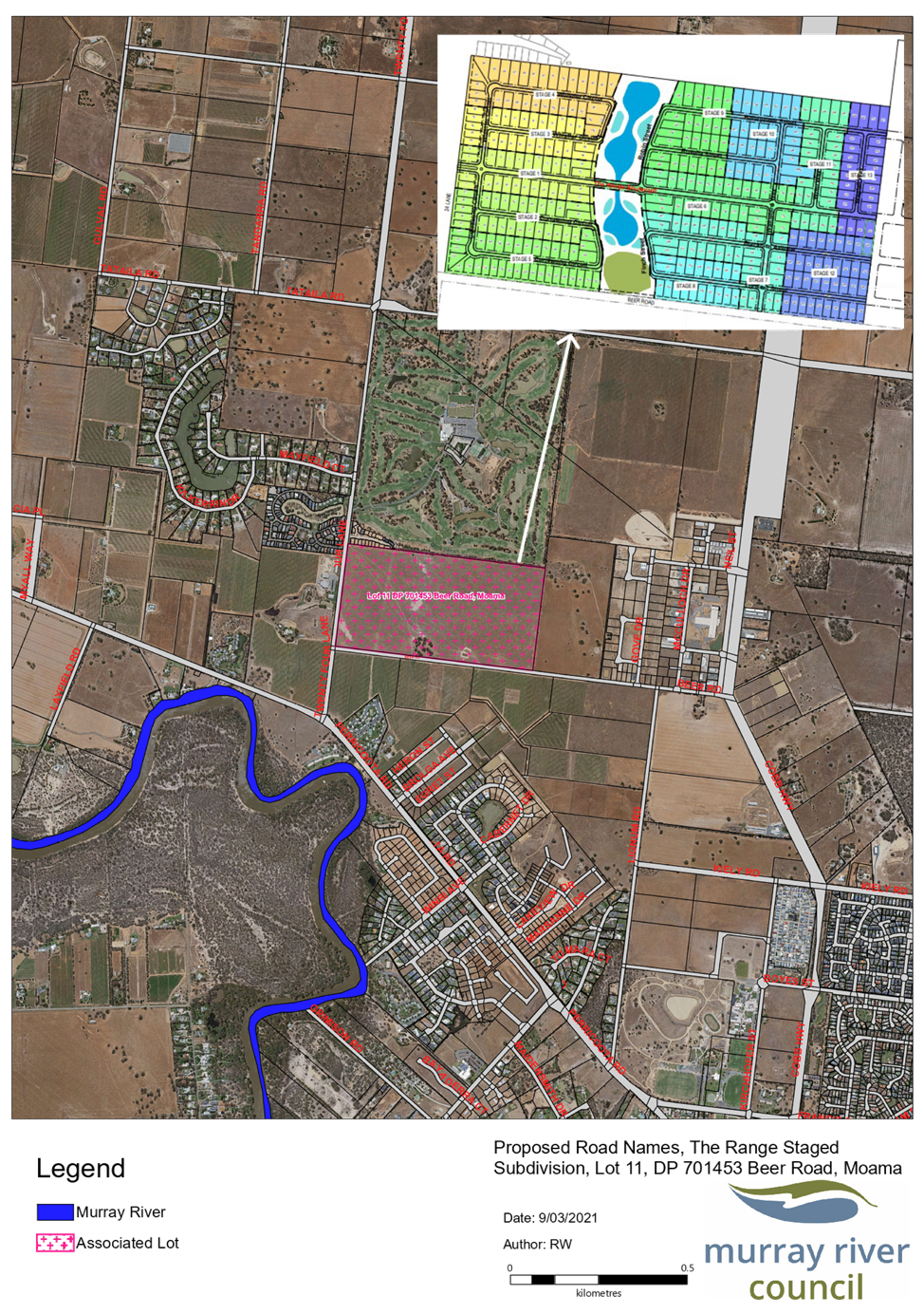
Background
Council has received a
request from the developers of “The Range” to name the roads within
the staged subdivision of Lot 11, DP 701453, Beer Road, Moama.
Discussion
For the purposes of the
Geographical Names Board NSW Address Policy Council are responsible for
endorsing the authoritative road name of public roads and ensuring they are
approved by the Geographical Names Board and gazetted.
The suggested names are
based around Native Birds of Australia which are current in the Murray Region
and comply with the requirements of the Geographical Names Board. The suggested
names are as follows. Their location is shown in Attachment 1.
· The Range Boulevard
· Whistler Circuit
· Currawong Circuit
· Honeyeater Street
· Rosella Street
· Wren Way
· Wagtail Way
· Wattlebird Way
· Blackbird Avenue
· Lorikeet Street
· Finch Street
· Robin Street
If approved by Council, these names are then advertised on
council’s website for public comment for 14 days. If no objections are
received, Council will lodge the proposed names through NSW Place & Road
Name Proposal System.
NOTE: The requirement under the Road Regulations
2018 to notify relevant authorities is undertaken automatically once the
proposed name(s) are lodged through the NSW Place & Road Name Proposal
System.
If no objections are received through NSW Place & Road
Name Proposal System, notification is sent advising that the road names have
been approved, road names are then Gazetted through the NSW Government Gazette
Online Portal.
If objections are received during the process, management
may request amendments to the proposed names and then prepare a new report for
Council’s consideration.
Council will then notify Spatial Services Road Updates &
Geographical Names Board NSW who
will then update the mapping and associated databases.
Council will then advise the Developer/Applicant that the
Road Names have been approved.
Strategic Implications
5 - Strategic Theme 5: Leadership and Governance
5.4 - Develop and pursue advocacy on behalf of the community
5.4.1 - Pursue advocacy on key issues of importance to the
community and Council
Budgetary Implications
Nil.
Policy Implications
Nil.
Legislative Implications
Roads Act 1993.
Risk Analysis
· What
can happen?
The roads remain unnamed.
· How
can it happen?
Roads not approved and gazetted.
· What
are the consequences of the event happening?
Difficulty identifying property,
no spatial reference.
· What
is the likelihood of the event happening?
Medium to high
· Adequacy
of existing controls?
Adequate as Council staff are
available to carry out the formality of naming and gazetting the public roads.
· Treatment
options to mitigate the risk?
Council to pass a resolution to
name the public roads.
Conclusion
The proposed public road names comply with the Geographical
Names Board guidelines for the naming of roads and are therefore supported.
Attachments
1. Proposed
Road Names - The Range Staged Subdivision - Lot 11 DP 701453 Beer Road Moama ⇩ 
2. Location
Map - Lot 11 DP 701453 Staged Subdivision, Beer Road, Moama ⇩ 
|
MURRAY RIVER COUNCIL Ordinary
Council Meeting Agenda
|
23 March 2021
|
|
MURRAY RIVER COUNCIL Ordinary
Council Meeting Agenda
|
23 March 2021
|
9.3.5 Proposed
partial closure of War Street Moama, from Council to Warden Street
File
Number: -
Author: Brodie
Goodsell, Manager Asset Systems
Authoriser: Scott
Barber, Director Operations & Major Projects
|
Recommendation
1. That Council
approve the amended partial closure of War Street, from Council street to
Warden Street, Moama
2. The
proposed closure be notified in accordance with Part 4, Division 3 of the Roads Act 1993.
3. Councils seal be affixed to all documents
relating to the road closure
|
Background
In July 2020 Council resolved to close the public road of
War Street Moama between Council Street and Warden Street, Moama, as shown in blue
in Attachment 1. The proposed closure was initiated to support the expansion of
the Moama Lions Community Village located to the west of the site. In
accordance with Part 4, Division 3 of the Roads Act 1993 notification of the
intended closure was sent to adjoining landholders. Council received
objections from 4 adjoining land holders, and subsequently met onsite to
discuss their concerns. Following the site meeting a revised partial closure
has been proposed.
Discussion
Following receipt of 4 objections to the proposed full road
closure of War Street an onsite meeting was conducted with Council staff,
representatives of the Moama Lions Community Village Committee and adjoining
landholders. Based on these discussions an amended partial road closure
has been proposed for War Street, between Council and Warden Streets, as shown
in Attachment 2.
This partial closure would entail Council retaining a 9m
wide road reserve to allow access for adjoining landholders and conveyance of
services as shown in the attached. Two new lots would be created on the
closed section of road reserve, with a 4m wide easement placed over the
drainage and sewer services within these new lots. This will allow for the construction
of the additional proposed Lions units, protection of Council’s existing
services and guarantee continued access for adjoining landholders. Finalisation
of the unit designs are currently in progress.
Strategic Implications
3 - Strategic Theme 3: Social Wellbeing
3.3 - Support and enable our community
3.3.4 - Plan, advocate and encourage investment in aged care
and disabled services (home-based, community-based)
Budgetary Implications
Nil.
Policy Implications
Nil.
Legislative Implications
Risk Analysis
· What
can happen?
Access for adjoining landholders
and service providers is removed or compromised.
· How
can it happen?
Objections received due to
complete closure of War street from Council to Warden Street, Moama
· What
are the consequences of the event happening?
Refusal of road
closure application by approval bodies
· What
is the likelihood of the event happening?
High
· Adequacy
of existing controls?
Good, in that
amended proposal for partial closure has been provided
· Treatment
options to mitigate the risk?
Council pass a resolution supporting
the amended partial road closure
Conclusion
Following consultation with Council staff, representatives
of the Moama Lions Community Village Committee and adjoining landholders an
amended partial road closure has been proposed for War Street, between Council
and Warden Streets. This proposal is mutually beneficial for all involved
parties and will allow for the construction of additional Lions Units,
continued adjoining landholder access and the conveyance and protection of
services.
Attachments
1. Map
- War Street Original Full Road Closure Proposal ⇩ 
2. Map
- War Street Amended Partial Road Closure Proposal ⇩ 
3. Draft
Plan - Moama Lions Village Units Concept - Confidential
|
MURRAY RIVER COUNCIL Ordinary
Council Meeting Agenda
|
23 March 2021
|
|
MURRAY RIVER COUNCIL Ordinary
Council Meeting Agenda
|
23 March 2021
|
9.4 Director
Planning and Environment Report and Supplementary Matters
9.4.1 Planning & Environment
Directorate - Monthly Activity Report
File
Number: -
Author: Rod
Croft, Interim Director Planning & Environment
Authoriser: Terry
Dodds, Chief Executive Officer
|
Recommendation
That the Planning & Environment Directorate - Monthly
Activity Report for
the period 1 February to 28 February 2021 be received and the information noted by the Council.
|
Discussion
This report details the activities of Council’s Planning
and Environment Directorate from 1 February to 28 February 2021.
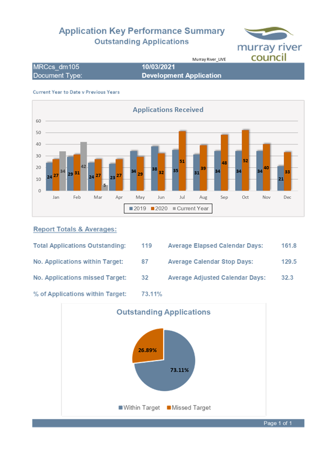
We have seen an increase in development applications in the
month of February in comparison to previous years, which is linked to federal
and state Government COVID incentives, which has put additional pressure on the
planning and building staff. That aside, it is pleasing to see that planning
and building staff are determining applications 73.11% within Statutory
timeframes, which is a great result from a team that is under resourced at the
moment.
At the time of writing the report we have recruited a
Victorian Building Surveyor (approx. 12-month process for re- accreditation
from Vic to NSW), Senior Town Planner, trainee administration officer and two
planning cadets. They will have some immediate impact on the business as well
as securing a succession planned future for the department.
The other Senior Building Surveying position that we could
not fill, will be changed and re-advertised as an Environmental Health Officer.
This will allow Council to cover off risks of an environmental nature and shift
some of the food premises related duties from Building Surveyors so that the
building department can re-focus on housing and development as a priority.
Information regarding the building services issues to
recruit skilled staff into Council has been given to councillors to understand
the options we have considered to improve the situation. We will continue to
seek solutions from State government over the coming months.
The electronic lodgement of development applications is
mandated for Councils to use this system by 1st July 2021, known as
the E-Planning Portal. This is a great step forward and will allow applicants
to see live status information in relation to their individual application.
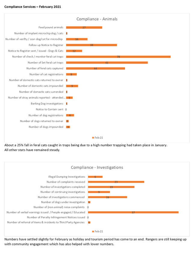
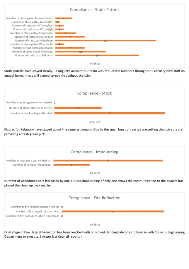
Regarding compliance services, there are still a significant
number of incidents particularly with livestock and companion animal issues as
well as other compliance complaints over vehicles and planning enforcement
assistance. There have also been alleged illegal structures been erected on
riverfront areas that are currently under investigation that will involve
assistance from other government agencies.
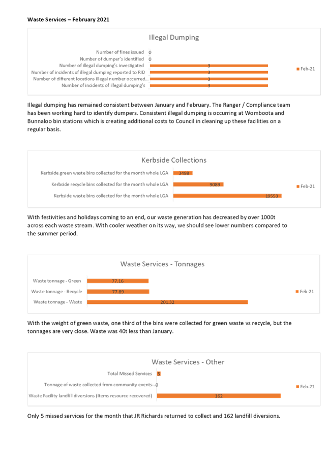
Waste services is getting some great data, that will inform
and focus our operations going forward. Illegal dumping of waste is a common
trend that has continued over the summer months, that are continuing to be
investigated. We have seen an increase in gate income activity from the
commercial sector and we aim to increase that as we roll out the Waste
Strategy.
Attachments
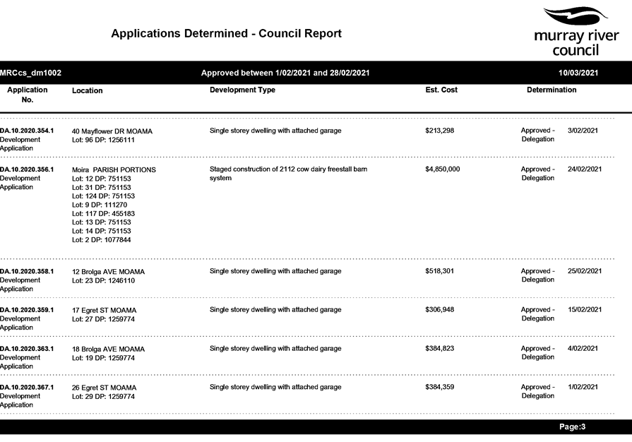
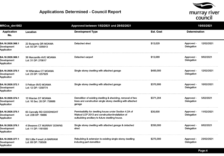
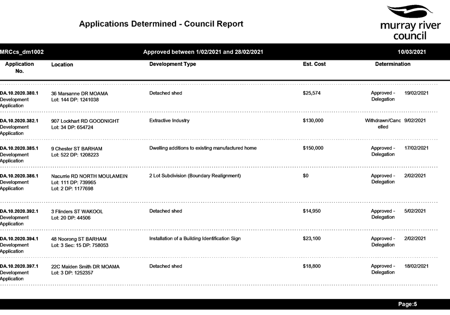
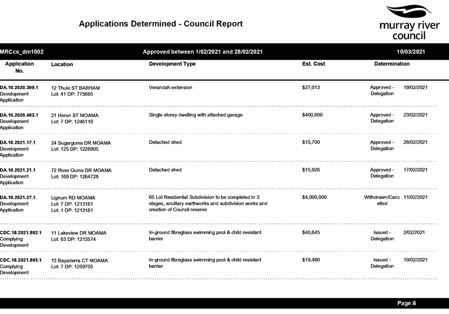
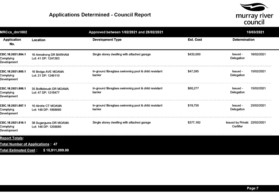
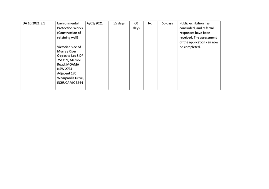
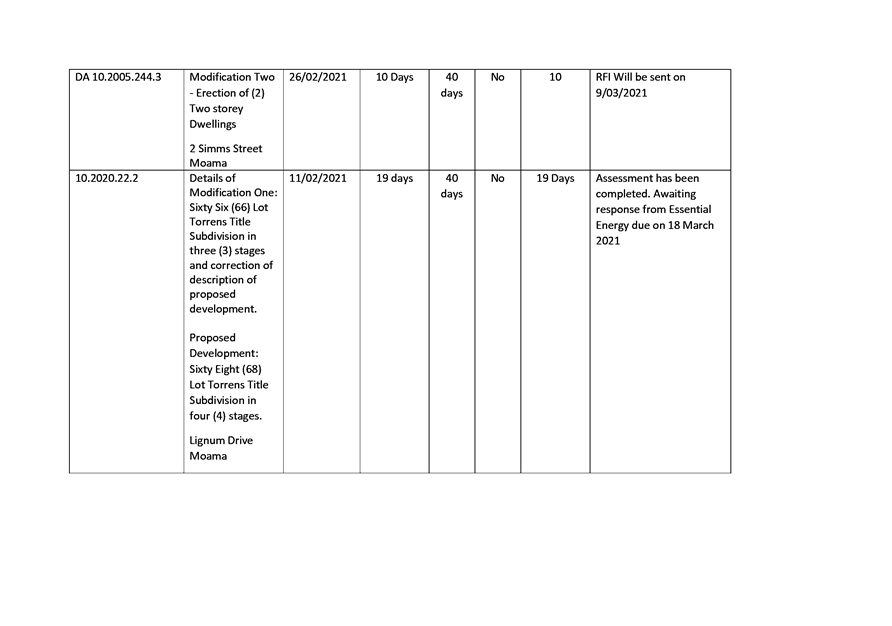
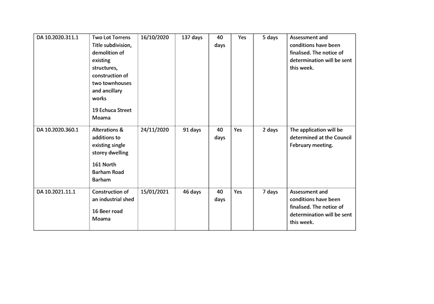
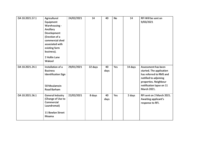
1. Applications
Determined - February 2021 ⇩ 
2. Application
Key Performance Summary – Outstanding Applications as at 10 March 2021 ⇩
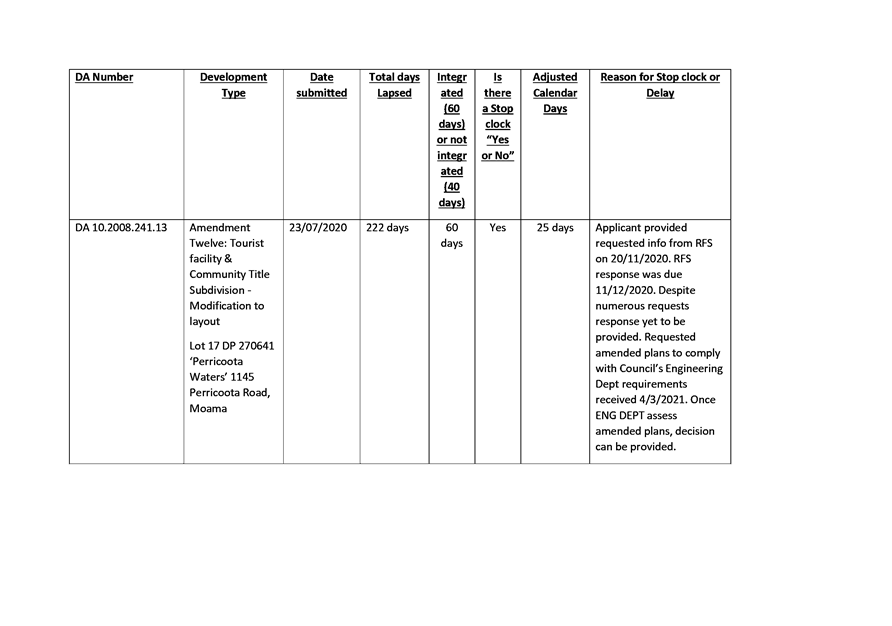
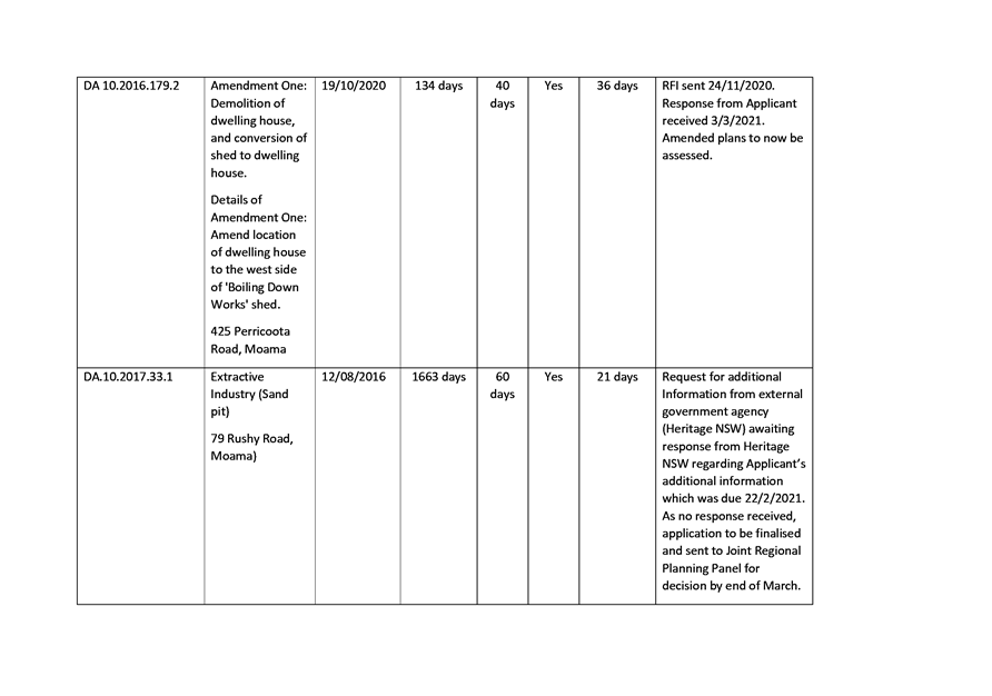
3. DA
Performance Report Planning - February 2021 ⇩
4. Compliance
Report - February 2021 ⇩
5. Waste
Report - February 2021 ⇩
|
MURRAY RIVER COUNCIL Ordinary
Council Meeting Agenda
|
23 March 2021
|
|
MURRAY
RIVER COUNCIL Ordinary Council Meeting Agenda
|
23 March 2021
|
|
MURRAY RIVER COUNCIL Ordinary
Council Meeting Agenda
|
23 March 2021
|
|
MURRAY
RIVER COUNCIL Ordinary Council Meeting Agenda
|
23 March 2021
|
|
MURRAY
RIVER COUNCIL Ordinary Council Meeting Agenda
|
23 March 2021
|
9.4.2 Extension
to existing single storey dwelling including part demolition
File
Number: -
Author: Gayan
Wickramasinghe, Town Planner
Authoriser: Rod
Croft, Interim Director Planning & Environment
Applicant: Rick
Driscoll
Owner: B
Driscoll
Proposal: Extension
to existing single storey dwelling including part demolition
Location: Lot:
462 DP: 748396, 161 North Barham Road BARHAM 2732
|
Recommendation
That the Officer’s report be
received and noted; and
That
Development Application 10.2020.360.1 be refused for the following reason:
1. The
application relates to prohibited development under Part 6 Section 6.6 (2)
(b) of the Wakool Local Environmental Plan (WLEP) 2013 being related to extension of an existing building which
will be located closer to the riverbank than the existing building. The
resulting non-compliance results in the development not satisfying Section
4.15(1)(a)(i) of the Environmental Planning and Assessment Act 1979.
|
Background
This
report considers a development application
for extension to existing single storey dwelling including part
demolition at the subject site which is not consistent with Section 6.6
(2)(b) of the WLEP 2013 and provides an
assessment of the application in accordance with the Environmental Planning
and Assessment Act 1979, Environmental Planning and Assessment Regulation 2000
and WLEP 2013. Following
exhibition of the Development Application, Council did not receive any
submissions.
Council
is being asked to consider the following issue with respect to this
application:
The proposed
extension to existing single storey dwelling including part
demolition is proposed under Section 2.3, Section 2.7 and Section 6.6
of the WLEP 2013. As part of the Development Application, the applicant has
provided a site plan outlining the existing and proposed setbacks to the high
bank of the Murray River (Localised Site
Plan; Dated 07/10/22020; Drawn by SM; Job No: 20-4329). As per the submitted plan the proposed
development is not consistent with Section 6.6 of the WLEP 2013.
As the subject development application is related to a river
front development, Section 6.6 of the WLEP 2013 (Development on river front areas) is
explicitly applicable in this instance.
As per WLEP 2013 river
front area means —
(Also available at: https://www.legislation.nsw.gov.au/view/whole/html/inforce/current/epi-2013-0655#sec.6.6)
(a) in Zone RU5 Village, Zone R1 General Residential, Zone R5
Large Lot Residential, Zone B2 Local Centre, Zone B6 Enterprise Corridor, Zone
IN1 General Industrial, Zone RE1 Public Recreation, Zone RE2 Private Recreation
or Zone SP2 Infrastructure—the land within 40 metres of the high bank of
the river, or
(b) in Zone RU1 Primary Production, Zone RU3 Forestry or
Zone E2 Environmental Conservation—the land within 100 metres of the high
bank of the river.
The subject
development site is zoned RU1 Primary Production. It is noted however as the
subject development site already contains a single-story dwelling, the proposed
development (extension) is not
required to meet a 100m setback from the high bank of the Murray River. Instead, the proposed development relies upon the provisions
outlined in Section 6.6 (2) of the WLEP 2013, as below: (also
available at: https://www.legislation.nsw.gov.au/view/whole/html/inforce/current/epi-2013-0655#sec.6.6)
(2) Despite any other provision of this Plan,
development consent may be granted to development on land in a river front area
only for the following purposes—
(a) boat building and repair facilities,
boat launching ramps, boat sheds, charter and tourism boating facilities or
marinas,
(b) the extension or alteration of an
existing building that is wholly or partly in the river front area if the
extension or alteration will be located no closer to the riverbank than the
existing building,
(c) environmental protection works,
(d) extensive agriculture and intensive
plant agriculture,
(e) environmental facilities, recreation
areas and recreation facilities (outdoor),
(f) water recreation structures.
As the
proposed additions will not be located no closer to the Murray
River high bank than the existing building, the proposal is inconsistent with Section
6.6 (2)(b) of the WLEP 2013. Council
has previously received legal advice regarding interpretation of Section 6.6(2)(b) of the WLEP
2013 on 8 August 2016 from Kell Moore
Lawyers. In summary the legal interpretation was that Section 6.6 (2)(b) is not a development
standard and written with prohibition, hence Section 4.6 of the LEP (exception
to development standards) and the Planning Circular PS 20-002: Variations to development
standards, cannot be utilized to vary Section 6.6 of the WLEP
2013.
As per Environmental Planning and Assessment Act 1979 development standards means:
provisions of
an environmental planning instrument or the regulations in relation to the
carrying out of development, being provisions by or under which requirements
are specified or standards are fixed in respect of any aspect of that
development, including, but without limiting the generality of the foregoing,
requirements or standards in respect of—
(a) the area, shape or frontage
of any land, the dimensions of any land, buildings or works, or the distance of
any land, building or work from any specified point,
(b) the proportion or percentage
of the area of a site which a building or work may occupy,
(c) the character, location,
siting, bulk, scale, shape, size, height, density, design or external
appearance of a building or work,
(d) the cubic content or floor
space of a building,
(e) the intensity or density of
the use of any land, building or work,
(f) the provision of public
access, open space, landscaped space, tree planting or other treatment for the
conservation, protection or enhancement of the environment,
(g) the provision of facilities
for the standing, movement, parking, servicing, manoeuvring, loading or
unloading of vehicles,
(h) the volume, nature and type
of traffic generated by the development,
(i) road patterns,
(j) drainage,
(k) the carrying out of
earthworks,
(l) the effects of development
on patterns of wind, sunlight, daylight or shadows,
(m) the provision of services,
facilities and amenities demanded by development,
(n) the emission of pollution
and means for its prevention or control or mitigation, and
(o) such other matters as may be
prescribed.
Discussion
Please refer to the section
“Background” above.
Subject
Site
The site subject to this development application is located
at 161 North Barham Road Barham 2732 on Lot: 462 DP: 748396. Land size is 8.997
ha.
The site is zoned RU1 Primary Production.
The subject site is an irregular shaped block, with the rear property boundary
backing on to the Murray River and bordered by Lot 41 DP 756571 to
the south and Lot 813 DP
1270172 to the west. The site is essentially flat and
has significant vegetation cover scatted all around the site. (Refer to site
inspection photos). Existing access
is provided from all-weather sealed North Barham Road. It is however noted that
no upgrade is required to the access as part of the development consent.
The development site is mapped as
Murray Regional Environmental Plan No. 2 – Riverine Land. It is also
noted that the land is not formally mapped as Flood Prone Land under the LEP,
however the entire development site is mapped as a Flood Prone Area as per
previous Wakool Shire Council’s Barham flood study. The existing
residence is positioned toward the west of the Murray River and setback
approximately 80m from the high riverbank.
Proposal
The applicant is seeking Council
permission for extension to existing single storey dwelling including part
demolition work.
The development comprises the following:
· A
new first floor with approximate 92.2sqm
· Add
three (03) new balconies to first floor;
· Renovation
of 22.4sqm internal floor area within the ground floor.
The applicant has also provided
the following documents to support the application:
· A
site plan, floor plan, elevation diagrams of existing and the proposed
dwelling;
· Statement
of Environmental Effects (SOEE);
· Completed
application form;
· An
AHIMS Search.
The proposed cost of development
is $150,000.
The
existing subdivision pattern and location of existing development within the
locality is shown in the following aerial photograph.
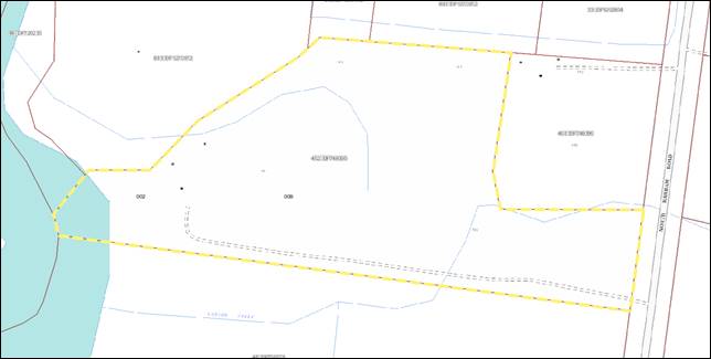
Figure 1 – Locality. Source: ePlanning Spatial Viewer
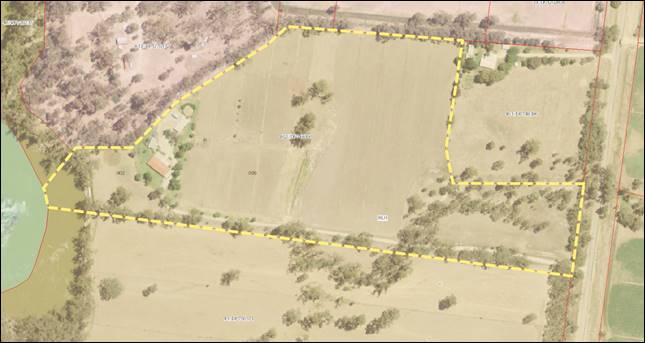
Figure 2 – Aerial photograph of subject site. Source:
ePlanning Spatial Viewer
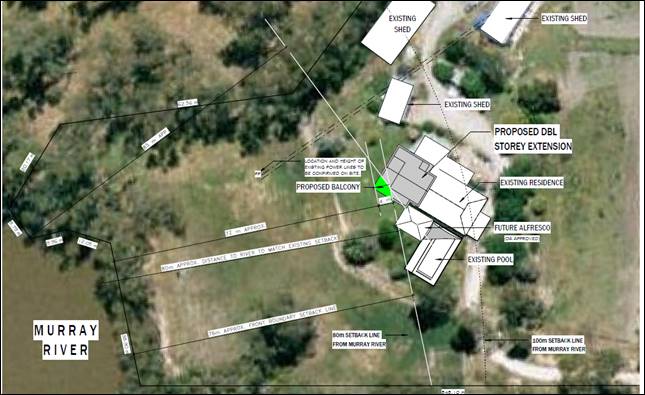
Figure 3 – Proposed Site Plan by the applicant
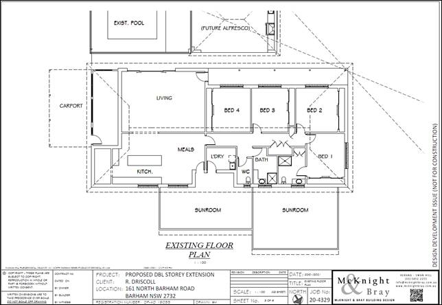
Figure 4 – Existing Floor Plan by the applicant
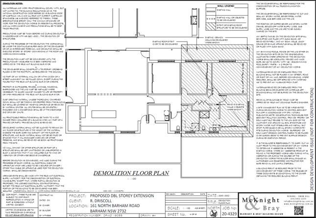
Figure 5 – Plan outlining the demollition proposed within the first floor by the
applicant
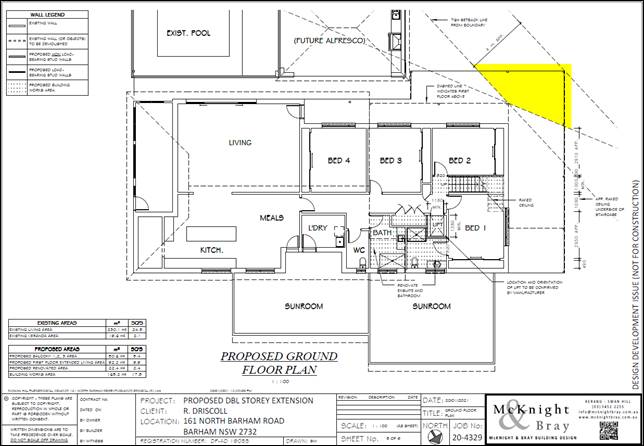
Figure 6 – Proposed ground floor Plan by the applicant
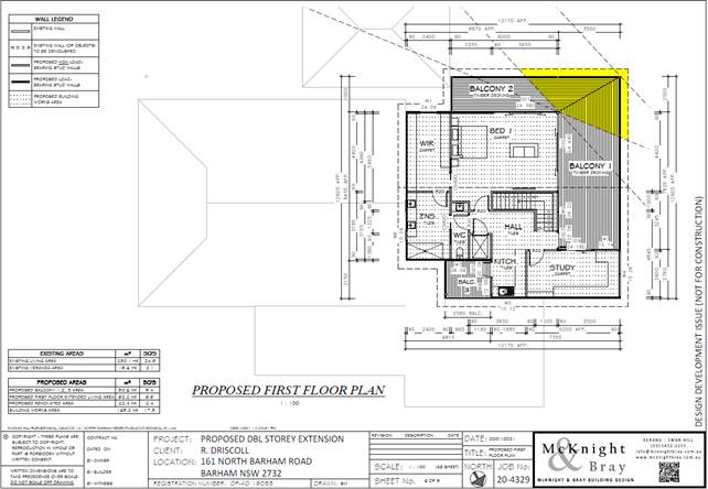
Figure 7 – Proposed first floor Plan by the applicant
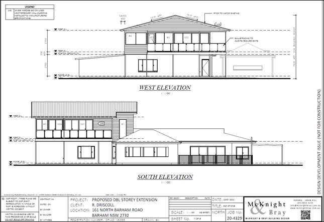
Figure 8 – Proposed west and south elevation diagrams by the applicant
Figure 9 – Proposed east and north elevation diagrams by the applicant
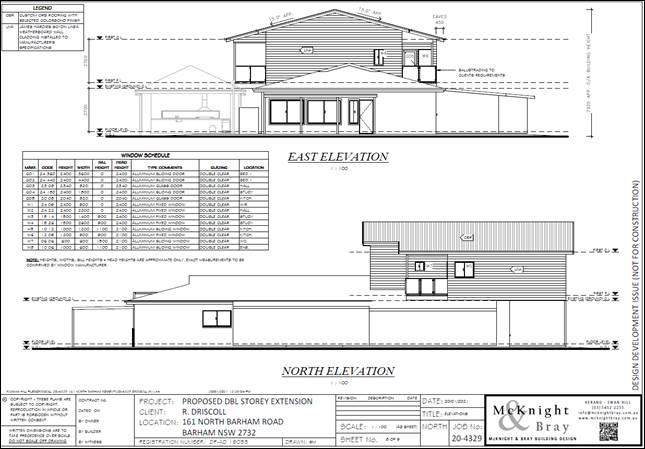
Figure 9 – Proposed east and north elevation diagrams by the applicant
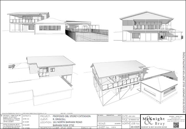
Figure 10 – 3D view of the proposed development by the applicant
Statutory Assessment Process
2.1 Environmental
Planning and Assessment Act 1979
Section 1.3 Objects
Comment: It is considered that the proposed
development is not inconsistent with the objects of the Act.
Section 1.7 Application of Part 7 of Biodiversity
Conservation Act 2016 and Part 7A of Fisheries Management Act 1994
Comment: It is considered that the proposed
development will not have a significant effect on the terrestrial and aquatic
environment, threatened species, populations or ecological communities, or
their habitats as no bed or bank works are proposed as part of this application.
As per the completed SOEE, the applicant has indicated that no vegetation is
required to be removed as part of this application. It is therefore noted Council
officers are satisfied that the proposal is not inconsistent with Part 7 of the
Biodiversity Conservation Act 2016 and Part 7A of the Fisheries
Management Act 1994. In the event if Council approves the development
application, it is recommended to apply a condition of any consent granted to
reflect this requirement.
Section 4.14 Consultation and development
consent—certain bush fire prone land
Comment: The subject land is
not being identified as a bushfire prone as per ePlanning Spatial Viewer
Bush Fire Prone Land Map (BFPLM).
Section 4.15 Evaluation
Comment: This report provides the necessary review and
evaluation of the development application. See below.
Section 4.46 What is “integrated
development”?
Comment: The application is not classed as
Integrated Development as it does not require a separate approval from any
other Acts mentioned under this section.
2.2 Chronology of events and
public notification and statutory referral process.
The below table provides an overview of the timeline with
respect to the lodgement and assessment of the application.
Application history/timeline
|
Application lodged
|
01/12/2020
|
|
DA Panel
|
25/11/2020
|
|
Neighbour Notification
|
From 2 December 2020 to 17 December 2020
|
|
Further information requested
|
24/2/2021
|
|
Further information received
|
9/03/2021
|
|
Site Inspection
|
15/01/2021
|
2.2 Referrals
and Owners Consent
Internal Referrals- DA Panel
External Referrals- Not required.
Advertised- The application was advertised on the
Council’s website from 2 December 2020 to 17 December 2020.
Public Notification- The application was notified to
adjoining property owners from 2 December 2020 to 17 December 2020 in accordance with the Wakool DCP 2013 A.3 Notification &
Advertising policy. (Please
refer to section 3.5(d) within the report for additional comment).
Owners Consent- Provided.
2.4 Contributions
Section 7.11 (formerly Section 94) Development Contributions
are not required.
Section 64 contributions are not required.
Town Planning Assessment
Assessment
of the development application has been undertaken in respect to relevant
considerations arising from Section 4.15 of the Environmental Planning and
Assessment Act 1979 as follows:
3.1 Section
4.15 Evaluation
(1) Matters for consideration-general
In
determining a development application, a consent authority is to take into
consideration such of the following matters as are of relevance to the
development the subject of the development application:
(a)
the provisions of:
(i) any environmental
planning instrument, and
(ii) any proposed
instrument that is or has been the subject of public consultation under this
Act and that has been notified to the consent authority (unless the Planning
Secretary has notified the consent authority that the making of the proposed
instrument has been deferred indefinitely or has not been approved), and
(iii)
any development control plan, and
(iiia) any
planning agreement that has been entered into under section 7.4, or any draft
planning agreement that a developer has offered to enter into under section
7.4, and
(iv) the
regulations (to the extent that they prescribe matters for the purposes of this
paragraph), and
(v) (Repealed)
that apply to the land to
which the development application relates,
(b) the likely impacts of that development, including
environmental impacts on both the natural and built environments, and social
and economic impacts in the locality,
(c)
the suitability of the site for the development,
(d)
any submissions made in accordance with this Act or the regulations,
(e)
the public interest.
Matters for consideration
3.2(a)
the provisions
3.2(a)(i)
Environmental Planning Instruments
3.2(a)(i)a Wakool Local Environmental Plan 2013 (Available:
https://www.legislation.nsw.gov.au/#/view/EPI/2013/655)
Part 1 Preliminary
Section 1.2 Aims of Plan
Comment:
The proposed development is not specifically consistent with the aims of Wakool
LEP 2013 as it does not comply with a specific assessment criterion.
Section
1.9A Suspension of covenants, agreements and instruments
Comment: For the purpose of enabling development on land in any zone
to be carried out in accordance with this plan or with a consent granted under
the Act, any agreement, covenant or other similar instrument that restricts the
carrying out of that development does not apply to the extent necessary to
serve that purpose.
Part 2 Permitted or
prohibited development
Section
2.3 Zone objectives & Land Use Table (development permissibility)
Zone:
RU1 Primary Production
§ To encourage sustainable primary industry production by maintaining
and enhancing the natural resource base.
§ To encourage diversity in primary industry enterprises and
systems appropriate for the area.
§ To minimise the fragmentation and alienation of resource
lands.
§ • To minimise conflict between land uses
within this zone and land uses within adjoining zones.
§ To promote the use of agricultural land for efficient and
effective agricultural production without the encroachment of urban land uses.
§ To allow the development of processing, service and value-adding
industries related to agriculture and primary industry production.
§ To allow the development of complementary non-agricultural
land uses that are compatible with the character of the zone.
Comment:
The proposed development is not considered to be inconsistent
with the objectives of the RU1 Primary Production Zone of the Wakool LEP 2013. The applicant is seeking
Council permission for part demolition and extension to existing single storey
dwelling. Due to the use being continuous, there will be no conflict between
the subject site and the neighbouring land uses. The applicant has also
indicated that no vegetation is proposed to be removed as part of this
application. Therefore, the proposed development will not have any adverse impact on the natural resource base of
the land. As such the proposal is consistent
with the Wakool LEP 2013 and the objectives of land zoned RU1 Primary
Production. Dwelling
Houses are permitted with consent on land zoned RU1, as such the proposal for
extension to existing dwelling including part demolition is considered to be
consistent with the above objectives.
Section
2.7 Demolition requires development consent
Comment: The proposed demolition requires a development
consent as it is not being identified as exempt development under
this plan or State Environmental Planning Policy (Exempt and Complying Development
Codes) 2008.
Part
3 Exempt and complying development
Comment:
The proposed development cannot be classed as complying or exempt development.
Part 4 Principal
development standards
Comment: No Principal
Development Standards are applicable to the proposed development.
Part
5 Miscellaneous provisions
Section 5.10 Heritage
conservation
Comment: As per the
submitted AHIMS search, the site does not contain any known items of
Environmental Heritage Significance. It is the responsibility of the Applicant
to ensure compliance with the Due Diligence Code of Practice for the
Protection of Aboriginal Objects in New South Wales. Any consent issued
will contain the standard Heritage NSW condition regarding protection of
Aboriginal Cultural Heritage.
Part
6 Additional local provisions
Section
6.1 Earthworks
Comment:
No significant earthworks will incorporate for the proposed development. As per
the submitted plans (demolition floor plan & the proposed floor plans),
most of the new development will utilise the existing footprint. As the
applicant is proposed to construct a double storey extension, to support the
double storey the applicant is required to install beams on ground, which
requires some earth works. As these earthworks are only to be limited to the
foundation (i.e. boring footing for structural foundations) the
assessing officer does not believe that any ancillary earthworks will bring any
detrimental impacts on existing drainage patterns and soil stability in the
locality. The assessment officer of this application believes that
subject to appropriate conditions on the consent (i.e. sediment control
measures, protection of any potential Aboriginal items etc.) the similar
consistency can also be achieved and the proposal meets the objectives of this
section and the relevant assessment criteria outlined in Section 6.1(3).
Section
6.2 Flood planning
Comment:
The subject development site has not been identified as a flood prone area in
accordance with the Wakool LEP 2013. The applicant in their respective SOEE has
indicated that the subject development site is not being inundated with flood.
It is however noted that the subject development site is covered by the flood
study carried out by the previous Wakool Shire Council in 2014. Therefore,
Council as the consent authority is required to consider if the proposed development
complies with assessment guidelines outlined in Section 6.2(3) and meets the
objectives as outlined in Section 6.2(3). In this regard the following is
noted:
1. As
per the proposed ground floor plan, the only external works proposed include construction
of a concrete veranda and installation of beams to support for the proposed
first floor. The proposed concrete veranda will be approximately 46.72sqm and
is to be located around the proposed Bedroom One (1) & Two (2). As the
proposed concrete veranda is not considered to be a habitable component of the
dwelling it is considered that the proposal will not significantly adversely
affect flood behaviour resulting in detrimental increases in the potential
flood affectation of other development and is not likely to result in unsustainable social and economic costs to
the community as a consequence of flooding. Please also refer to assessment
against Section B.2.4 Flood Planning of the Wakool DCP 2013 for
additional information.
2. The
applicant however has failed to provide specific flood height applicable to the
development site. As part of the development, the applicant has proposed to
build a double storey extension. As no specific data has been presented by the
Applicant Council officers cannot verify if the proposed extension is
compatible with flood hazard of the land or it will significantly adversely
affect flood behaviour resulting in detrimental increases in the potential
flood affectation or if it is likely to result in unsustainable social and
economic costs to the community as a consequence of flooding.
It is
therefore noted in the event if Council approves the development application, a
deferred commencement condition will be included on any consent granted stating
that “proponent must submit a certificate from an NSW Registered Land
Surveyor showing that the finished floor level of the proposed double storey
extension approved under this consent is 500mm above the 1 in 100 Year ARI
Flood Level for the site.”
Section
6.4 Riparian land and watercourses
Comment:
As per the submitted site plan the proposed development is located
approximately 72m from the high bank of the Murray River.
The applicant is only seeking Council consent for
extension to existing single storey dwelling and demolition of an
existing portion of the dwelling). As per the
submitted SOEE, the applicant is not seeking to remove any vegetation or is not
intending to extract water from the Murray River. It is therefore considered
that the proposed development is consistent with the assessment criteria
outlined in Section 6.4 (3) of the WLEP 2013. As a result, Council is satisfied
that the proposed development will not have any significant
adverse environmental impact (including cumulative and
concurrent impact) and meets the following objectives of this section:
(a) water
quality within watercourses,
(b) the
stability of the bed and banks of watercourses,
(c) aquatic
riparian habitats,
(d) ecological
processes within watercourses and riparian areas.
It is therefore considered that the proposed development is consistent
with this section.
Section
6.5 Wetlands
Comment:
The objective of this Section is to ensure that wetlands
are preserved and protected from the impacts of development. Small portions of
the far western and eastern sections of the development site is mapped as
wetlands. As per submitted plans no works are proposed to occur on those
specific sections. As discussed previously within the report the proposed
development does not warrant removal of trees. In fact, the proposed
development is largely to use the existing footprint. It is therefore
considered that the proposed development is unlikely to have any significant
adverse impact on the existing native fauna and flora or quality of habitats on
the land for indigenous and migratory species and considered to be met the
assessment criteria in Section 6.5 (4) and Council as the consent authority is
satisfied that the proposed development is sited and designed to manage
any potential adverse environmental impacts.
Section
6.6 Development on river front areas
(1) The objectives of this clause
are as follows—
(a) to support the
natural migration of the river channel, including riverine processes,
(b) to protect and
improve the bed and bank stability of rivers,
(c) to maintain or
improve the water quality of rivers,
(d) to protect the
amenity, scenic landscape values and cultural heritage of rivers,
(e) to protect public
access to riverine corridors,
(f) to conserve and
protect riverine corridors, including wildlife habitat.
Comment:
The proposed development is not considered to be inconsistent with the above
objectives. Importantly, the proposed development will not have detrimental
impacts on the amenity, scenic landscape values and cultural heritage of
river.
(2) Despite any other
provision of this Plan, development consent may be granted to development on
land in a river front area only for the following purposes—
(a) boat building and
repair facilities, boat launching ramps, boat sheds, charter and tourism
boating facilities or marinas,
(b) the
extension or alteration of an existing building that is wholly or partly in the
river front area if the extension or alteration will be located no closer to
the river bank than the existing building,
(c) environmental
protection works,
(d) extensive
agriculture and intensive plant agriculture,
(e) environmental
facilities, recreation areas and recreation facilities (outdoor),
(f) water recreation
structures.
Comment:
Council consent is required for the proposed development as per Section 6.6
(2)(b) of the WLEP 2013. It is noted however, as the proposed extension will
not be located no closer to the riverbank than the existing building the
proposed development is not consistent with this section. As discussed within
the background of this report, this matter was previously raised with Kell Moore Lawyers. In summary the legal
interpretation was that if the Applicant proposes to extend the existing
dwelling which does not meet relevant setback provisions (100m) the applicant
is required to maintain the existing setback to the high bank of the river.
Of
note, as per WLEP 2013, river means
the Murray River, the Edwards River, the Wakool River and the Murrumbidgee
River.
The applicant however made a submission in support of the
development application seeking a variation to the above provision (6.6
(2)(b)). The submitted submission is outlined in Section 3.5(d)
of this assessment report.
(3) Development
consent must not be granted for a purpose specified in subclause (2) unless the
consent authority is satisfied of the following—
(a) that the
development will contribute to achieving the objectives for the zone in which
the land is located,
Comment:
As outlined previously, the proposed development is consistent with the
objectives of the RU1 Primary Production zone of the Wakool
LEP 2013. Due to the use being continuous, there will be no conflict
between the subject site and the neighbouring land uses. The applicant has also
indicated that no vegetation is proposed to be removed as part of this
application. Therefore, the proposed development will not have any
adverse impact on the natural resource base of the land.
(b) that the
appearance of the development, from both the river and adjacent river front
area, will be compatible with the surrounding area,
Comment: As noted during the site inspection and as per NSW
ePlanning Spatial Viewer, the western and north western sections of the
development site contains mature vegetation. As no vegetation is proposed to be
removed and due to the considerable distance to the high bank of the Murray
River, it is considered that the proposal will not drastically change the
appearance of the existing development site.
(c) that the
development is not likely to cause environmental harm such as—
(i) pollution or
siltation of the river, or
(ii) an adverse
effect on surrounding uses, marine habitat, wetland areas, fauna or flora
habitats, or
(iii) an adverse effect on
drainage patterns,
Comment: As no trees are planned to be removed or no bed and bank
works are proposed Council as the determination authority is satisfied that the
proposed development will not cause environmental harm. It is noted however a
condition will be recommended to include on the consent regarding the
management of stormwater, in the event Council approves the application.
(d) that the
development will only cause minimal visual disturbance to the existing
landscape,
Comment: As noted previously and evident on the Aerial Images
within the report, the development site contains mature trees on the front end
facing the North Barham Road and along the southern, northern and western
boundaries. The existing vegetation on the site act as a screen and reduces the
visual impacts. Importantly the proposed extensions are to be located at the
rear end of the existing dwelling. Also, the existing dwelling is located
approximately 460m from the North Barham Road. It is therefore considered that
the proposal will only have minimal visual disturbance to the existing
landscape. Please also refer to assessment against 6.6 (3)(b) for further
comment.
(e) that continuous
public access, and opportunities to provide continuous public access, along the
river front and to the river, will not be compromised,
Comment: There is no public access to the river through the
development site. It is therefore considered that the proposal consistent with
this sub-section.
(f) that any
historic, scientific, cultural, social, archaeological, architectural, natural
or aesthetic significance of the land on which the development is to be carried
out and of surrounding land will be maintained.
Comment: The submitted AHIMS Search indicates that with a Buffer
of 50 meters there are no known Aboriginal sites are recorded in or near the
subject development site.
In summary, even though an assessment against Section 6.6 (3) has
been carried out by the officer, due to non-compliance with Section 6.6 (2)(b)
of WLEP 2013 the development is required to be refused.
Section
6.8 Essential services
Development
consent must not be granted for development unless the consent authority is
satisfied that any of the following services that are essential for the
development are available or that adequate arrangements have been made to make
them available when required:
|
Subclause
|
Comment
|
|
(a) the supply of water,
|
The applicant noted that an existing two (2) 22,500L rainwater
tanks are available on site. The applicant further noted that this
arrangement is in addition to extract water from the Murray River. It is
however noted that as per Wakool DCP 2013 a rainwater tank of minimum
storage of 90,000 litre is required if no Council reticulated water supply is
available. It is therefore a condition will be recommended in the event
should Council approves the development to reflect that requirement.
|
|
(b) the supply of electricity,
|
Electricity is available.
|
|
(c) the disposal and management of sewage,
|
The
proposed development will utilise existing toilet facilities on site. It is
however not clear if the existing system can service the proposed
development. It is therefore noted a condition will be recommended stating
that the applicant is required to provide a suitability assessment report of
the existing on-site-sewage system prior to any work.
|
|
(d) stormwater drainage or on-site conservation,
|
The
applicant noted that the additional storm water generated on site will be
directed to existing rainwater tank or will be managed on site. It is
therefore a condition will be recommended in the event should Council
approves the development to reflect that requirement.
|
|
(e) suitable vehicular access
|
Existing
access to the property.
|
Schedule
1 Additional permitted uses
Comment:
No additional permitted uses outlined in the Schedule are applicable to the
proposed development.
3.2(a)(i)b
Murray Regional Environmental Plan No. 2—Riverine
Land
Comment:
The subject site is mapped as Murray Regional Environmental Plan 2 –
Riverine Land. Consistent with objectives and principles.
3.2(a)(i)f
State Environmental Planning Policy (Koala Habitat Protection) 2020
Comment:
The subject land is not considered to be core koala habitat or potential koala
habitat.
3.2(a)(i)g
State Environmental Planning Policy No
55—Remediation of Land
Comment: The subject land
is not considered to be contaminated or likely to be contaminated and is not
listed on Council’s Contaminated Land Register. In accordance with
Section 7 of SEPP 55, Council is satisfied that, the land is suitable in its
current state for the purpose for which the development is proposed to be
carried out.
3.2(a)(i)l
State Environmental Planning Policy (Building
Sustainability Index: BASIX) 2004
Comment: The proposal
relates to a BASIX affected development.
BASIX affected development means
any of the following development that is not BASIX excluded development—
a) development
that involves the erection (but not the relocation) of a BASIX affected
building,
b) development
that involves a change of building use by which a building becomes a BASIX
affected building,
c) development
that involves the alteration, enlargement or extension of a BASIX affected
building, where the estimated construction cost of the development is—
(i) $100,000
or more—in the case of development for which a development application or
an application for a complying development certificate is made on or after 1
October 2006 and before 1 July 2007, or
(ii) $50,000
or more—in the case of development for which a development application or
an application for a complying development certificate is made on or after 1
July 2007,
As the construction cost of the
development is $150,000, the proposed development requires a BASIX Certificate.
A valid BASIX Certificate (A395822 dated 12 November 2020) has been submitted
with the application and the commitments have been shown on the plans. Plans
appear to be consistent with BASIX commitments.
3.2(a)(i)o
State Environmental Planning Policy (Exempt and
Complying Development Codes) 2008
Comment: The proposed
development cannot be classed as exempt or complying development as it does not
meet all of the development requirements.
3.2(a)(ii) Proposed
instruments
Comment:
Murray River Council Draft LEP 2021 soon applies. Same non compliance with
river front area Section applies.
3.2(a)(iii) Any development
control plan
Comment: Wakool Development Control Plan 2013:
Amendment 2 dated April 2015 applies to the proposal. Sections B.1, C.1, C.2,
C.3, C.4 and C.5 are relevant. Sections B.2, B.3, B.4, B.5, and B.6, are not
applicable.
Section B LAND USE TYPES
B.1 RESIDENTIAL & ANCILLARY USES
B.1.1 Site Planning
1) Objective(s): All development must:
a) Consider and respond to the
environmental opportunities and constraints on the site;
b) Avoid, or if it cannot avoid,
minimise or mitigate against any environmental impacts
or hazards or land use conflicts;
c) Protect and enhance any heritage
items or historic streetscapes;
d) Integrate with the surrounding
building and landscape character.
Comment: The supplied SOEE and the above assessment
against Sections 5.10, 6.1 and 6.8 of the Wakool LEP 2013 concluded that the
proposed development is likely to have a nil or minor impact on adjoining
landowners or surrounding environment. The site does not contain any heritage
items that are listed and described in Schedule 5 of Wakool LEP 2013.
Importantly this application relates to rebuilding (by demolition of an
existing portion of dwelling) of an existing dwelling largely to the same
footprint. Therefore, the proposed development is expected to be compatible
with the adjoining land uses.
B.1.2
Building Height
Objective(s):
To ensure that any development:
1) Integrates
with the height, bulk and scale of adjacent development and the character of
the area;
2) Minimises
overlooking and overshadowing of adjacent dwellings and their private open
spaces; and
3) Encourages
innovative roof forms that increase solar access to buildings (in winter
months) and/or have architectural merit.
As per the submitted elevation diagrams, the proposed development is
to have a total height of 7.92m to the ridge. As discussed within the report
due to the vegetation cover around the existing single storey dwelling and
substantial setbacks (approximately 28m to the nearest dwelling on adjacent
allotment) it is considered that the proposal will not overlook or
overshadow the adjacent dwellings and their private open spaces. Therefore, the proposed development is not
inconsistent with this part.
B.1.3
Building Setbacks
Objective(s):
Buildings should be setback from the lot boundaries:
a) To maximise
amenity for the proposed dwelling and any adjacent dwellings (including, but
not limited to, separation from road noise, adjacent building noise, privacy,
reasonable views, and overshadowing);
b) To allow
for sufficient fire protection and/or address fire requirements;
c) To allow an
area for landscape on the site for environmental and privacy benefits and to
reduce the visual impacts of any building(s);
d) To ensure the proposed building is consistent in setback (and the
appearance of bulk and scale) with the adjacent buildings whilst defining the
street edge and creating desirable street proportions;
e) To provide some articulation and/or variation to the
building elevations to provide visual interest.
In RU1
Primary Production zone where Lots are more than 1 ha
· 25m
(Increased setback may be required if lot fronts an unsealed road).
· 15m
(Inc. setbacks may be required if likelihood of impact on “right to
farm” of adjacent lot).
· 25m
(Increased setbacks may be required if likelihood of impact on “right to
farm” of adjacent lot).
Comment: As per submitted proposed site plan, the
proposed development complies with these controls. Therefore, no variation is
required. It is therefore considered that the proposal meets the objectives of
this Section.
B.1.5 Site Coverage
Objective(s): All residential
development should provide sufficient site area without buildings or
impermeable hard surfaces:
a) To avoid overdevelopment of the site and protect the
area character;
b) To encourage development that responds to the site opportunities
and constraints;
c) To protect existing significant trees and their root
systems;
d) To allow for infiltration of water, and significant
landscape and plantings;
e) To provide ground level open spaces and recreation
areas for the development;
f) To encourage passive solar design and energy
efficiency; and
g) To maximise residential amenity and privacy.
Comment:
As discussed within the report, the site subject to this development
application contains mature vegetation along the boundaries. It
is therefore considered the proposed development positively responds to the
attributes of the site. The
proposed first floor plan and the ground floor plan indicate that the total
floor area of the dwelling is to be approximately 280.7 m2, which is
well below the maximum site coverage of 70% given that the extent of the
development site is approximately 8.997 ha. Also, the proposed development orientated to the east providing
maximum solar access to the dwelling. The living, kitchen and bedrooms of the proposed
development are designed to provide natural cross ventilation through the
Aluminum sliding windows on either side of the walls.
B.1.6 Orientation, Solar Access and Cross Ventilation
Objective(s): All residential
developments should seek to incorporate passive design principles that will
contribute to the overall energy efficiency of residential dwellings and reduce
energy consumption including management of solar access and natural cross
ventilation.
Comment:
All the primary living areas within the proposed extension is
orientated directly to the east direction. Also, the elevation diagrams and
floor plans indicate that the proposed development incorporates large windows
and doors to be able to maximise solar access to the development. To support the
applicant’s argument, the applicant has provided a valid BASIX
Certificate. It is therefore considered that the proposed rebuilding and
additions are generally consistent with this part.
B.1.7 Private Open Space
Objective(s): Residential
development should incorporate sufficiently sized and suitably located outdoor
private open space and landscape areas:
a) To maximise amenity for each dwelling and
b) To maximise solar access to private open spaces and
living areas.
Comment: The proposed development complies with
this section.
B.1.8 Acoustic (Noise) & Visual Privacy
Objective(s): Development must
demonstrate how it will:
a) Preserve the visual privacy and minimise overlooking
of the living area(s) and private open space(s); and
b) Minimise unreasonable noise impacts;
Note: Single storey dwelling
development that meets the setback controls does not require specific privacy
controls
Comment: The application relates
to rebuilding and additions to existing single storey dwelling. As discussed in
the Section B 1.3 the proposed development meets the relevant setback
requirements. Therefore, it is considered that the proposed development meets
the objectives of this standard and is acceptable in this instance.
B.1.9 Building Articulation, Design & Materials
Objective(s): Building facades (especially for larger buildings or those facing
public spaces such as a public road, reserve, railway or adjoining residential
area) must incorporate variations in the façade treatments, roof lines
and building materials to avoid large blank walls, reduce bulk and scale of the
building, minimise reflective material, and provide visual interest.
Comment: The
applicant has indicated that the proposed development is to have timber weather
board walls with steel roof. As per north and east elevation diagrams, the roof
incorporates varying pitch with degrees. Therefore, it is considered that the
proposed development would provide visual interest and will blend into the
natural landscape in keeping with the area’s character.
B.1.10 Landscape
Objective(s): Landscape design
for residential development should address:
a) The shading of buildings in summer and their solar
access in winter, privacy, security, recreation and amenity of the subject site
and adjacent lots;
b) Suitability of species to the climate and local
ecology and minimising maintenance and watering requirements.
Comment:
No Landscaping Plan is required as no trees are to be removed
and the subject development site already contains mature trees.
B.1.13 Access & Parking
1) Objective(s): To ensure that all development is designed:
a) To promote safe and efficient access/egress to each
lot/development;
b) To provide appropriate areas for vehicle manoeuvring and turning;
and
c) To provide sufficient on-site
parking to minimise reliance on public roads for parking.
Comment: As
per, B.4 access & parking of the Wakool DCP 2013 (Page 90) the proposed
development should incorporate two car parking spaces within the property
boundary. During the site inspection it was witnessed that the subject
development site has ample room for car parking purposes. Therefore, this
standard is considered to be met.
C.1 NATURAL ENVIRONMENT
River front areas: For the purposes of
determining whether development consent is
granted for development that would result in tree
removal in river front areas then an “adverse impact” or
“environmental harm” or “visual disturbance” is deemed
likely to occur
when the tree(s) for removal:
a) Are identified in WLEP2012:
i) within 40m of the top of bank of
a watercourse identified on the Watercourse
Map in WLEP2012; or
ii) within 40m of a wetland
identified on the Wetland Map in WLEP2012; or
iii) within an area identified as „Biodiversity‟
on the Biodiversity Map in WLEP2012
and form part of a significant corridor of
biodiversity; and
b) Exceed the following dimensions:
i) Height greater than 6 metres; or
ii) Diameter greater than 30
centimetres (when measured 1.4 metres above
ground); and
c) There is a reasonable alternative location for the
proposed development that would
not cause this adverse impact/
environmental harm/ visual disturbance.
Comment: As no vegetation is proposed to be
removed, the proposal complies with this section.
B.1.2 WATERCOURSES & WETLANDS
Building Setbacks: WLEP2012 –
Section 6.6 – Riparian Land and the Murray River and other watercourses
sets the minimum setbacks for all buildings (and ancillary on-site sewerage
management systems) from the top of bank of key watercourses as follows:
· In
all urban zones (Zones R1 General Residential, Zone B2 Local Centre, Zone B6
Enterprise Corridor, Zone IN1 General Industry, Zone RU5 Village, Zone R5 Large
Lot Residential, Zone RE1 Public Recreation, Zone RE2 Private Recreation, Zone
SP2 Infrastructure) – 40 metres;
· In
all other rural and environmental zones – 100m.
Comment:
As discussed within this report, the development site is zoned RU1 Primary
Production. Therefore, the applicant is required to comply with 100m setback as
per this section. It is however due to the nature of the proposal (being
identified as extension and alteration to the existing building), the applicant
relies upon Section 6.6 (2)(b) of WLEP 2013 to proceed. The above assessment
against the relevant section concluded that the proposal is inconsistent with
that section.
B.2.3 Stormwater & Drainage
Objective(s):
a) To improve water conservation;
b) To reduce the volume and increase the water quality
of stormwater run-off;
c) To maintain existing stormwater drainage corridors
and watercourses to provide for extreme surface water flows;
d) To increase on-site storage of rainwater (where
suitable); e) To minimise damage to private and public property from
surface water flows during and after high intensity rainfall events.
Comment:
As noted in Section 6.8 - essential services, in the event if Council
approves the development application, a condition will be included to ensure
that the applicant is required to manage the stormwater on-site.
C.2 Hazards
B.2.4 Flood Planning
9) Residential Development outside a controlled levee
bank:
g).
Rebuilding part of a dwelling below the Flood Planning Level may be permitted
provided the building maintains the same dimensions which result in the same
impact on flood behaviour
Comment: As discussed within Section 6.2 of this
report, the proposed development is located outside a controlled levee bank and
the subject development site is mapped as a flood prone land. The Barham Flood
Study carried out by the Wakool Shire Council indicates that 1 in 100 flood
height for the site is 77.00m AHD. It is however noted the applicant has not
provided a site-specific flood height to support the application. In fact, the
applicant has indicated that the subject development site is not prone to
flood. It is therefore noted Council has no record if the existing dwelling is
above the required flood planning height.
In determining this application Council as the consent
authority is therefore required to ascertain if the proposed extension (first
floor) is above the relevant flood planning level. Of note, as per submitted
proposed floor plans, the applicant is planned to increase the floor area by
92.2sqm which is approximately 40% of the floor area of the existing dwelling.
As no record of the flood level is found the officer cannot ascertain if the
development site is located below the flood planning level or above the flood
planning level. Council officers believe that this should be determined prior
to activating any potential development consent. It is therefore noted in the
event if Council approves this application a deferred condition will be
included on the consent stating that the applicant must prove that the finished
floor level of the new section is above the 500mm freeboard to the flood
planning level.
C.3 Heritage & Culture
Comment: No known Aboriginal Items are recorded
within the site. A general condition however will be imposed to ensure
consistency.
C.5 URBAN AREA CHARACTER STATEMENTS
Comment: The
proposed development will promote greater housing choice, diversity and
affordability within the Barham urban area. The supplied SOEE indicates that no
vegetation is required to be removed as part of this application. Therefore,
the proposed development is considered to comply with the Wakool Development
Control Plan desired future urban character of the Barham area.
3.2(a)(iv) The regulations
Comment: Sections 92-98 of
the Environmental Planning and Assessment Regulation 2000
outline the matters to be considered in the assessment of a development
application. It is therefore noted in the event if Council approves the
application it is recommended that the prescribed conditions
to be included with any consent granted to ensure consistency.
3.3(b) the likely impacts of that
development, including environmental impacts on both the natural and built
environments, and social and economic impacts in the locality.
Site & Context
The
subject site is located within a rural-residential area currently zoned RU1
Primary Production under the provisions of Wakool Environmental Plan 2013. As
noted above, the bulk and scale of the proposed addition is compatible with the
site. The proposal will have minimal impact on the North Barham Road
streetscape due to the considerable setback and significant vegetation within
the development site. The assessment against Section 6.6(3) concluded that the
proposed extension will have minimal impact on the existing build form within
the neighbourhood.
Social Impacts
The proposed development is unlikely to
create any adverse social impact.
Economic Impacts
No adverse impacts. A likely positive
impact is that the development will maintain employment in the construction
industry, which will lead to flow impacts such as expenditure in the area.
Traffic and Parking
The development will not unreasonably
increase vehicle movements beyond the capacity of the local road network. No
upgrades to the existing separate points of ingress / egress are required.
Noise
It is anticipated there will be standard
construction noise and/or vibration associated with the proposed development.
Given the distance to adjoining dwellings (minimum of 27m from proposed
construction site) these impacts are deemed acceptable. In the event if Council
approves the development application, it is recommended that a condition which
outlining the standard construction hours be imposed with any consent granted
to mitigate potential adverse impacts.
Amenity
All required utilities are available to the subject site as
discussed under Section 6.8 within the report. It is noted however the
assessing officer is not satisfied that the existing on-site-sewage system is
capable of serving the proposed development. A condition is therefore
recommended to be included on any consent granted, in the event if Council
approves the development application.
Aboriginal Cultural Heritage
No known items identified on the subject
land. It is however a general condition will be imposed to ensure that the
proposed development will have minimum impact on any potential Aboriginal Cultural Heritage.
Soils, soil erosion
Minor soil disturbance will be required to enable the
construction of the development as outlined in Section 6.1 within the
report. It is however noted that subject to recommending standard erosion and
sediment conditions the proposal can still proceed.
Flora & Fauna
Construction of the proposed development
will not require any removal/clearing of any significant vegetation and
therefore will be unlikely to have any significant adverse impacts on biodiversity
or threatened species of flora and fauna. Please also refer to comment
against Section 1.7 within the report.
3.4(c) The suitability of the site for
the development
Comment: Even though, the proposal
will adequately fit into the locality, as per the above assessment the
proposed development does not conform to the specific assessment guidelines of
the WLEP 2013. The legal interpretation is that the specific assessment
criterion (Section 6.6(2)(b)) is not a development standard which
Council may vary. As such Council officers believe that the location
of the site is deemed to be unsuitable for the particular development.
3.5(d) any submissions made in accordance with this Act or the
regulations,
Government Agencies
· The development application was not required to refer to Government
Departments. Therefore, no submissions received.
Public Submissions:
· The development application was notified to public for 14 days.
Council did not receive any public submission objecting to the development. A
submission (attachment -03) was however made by Mcknight & Bray
Building Design in support of the development application seeking a variation
to the provisions for the following reasons:
Wakool Local Environmental Plan 2013
Part 6, 6.6 Development on river front areas
(2) Despite any other
provision of this Plan, development consent may be granted to development on
land in a river front area only for the following purposes—
(b) the
extension or alteration of an existing building that is wholly or partly in the
river front area if the extension or alteration
will be located no closer to the river bank than the existing building.
(e) environmental
facilities, recreation areas and recreation facilities (outdoor)
(f) water
recreation structures.(pools)
The above clause e and
f allows the possibility for an outdoor area and or pool to be approved closer
to the river than the existing residence provided the objectives to the clause
are complied with.
In this instance the
non-compliant structure Veranda & balcony (highlighted in attached plans
approximately 7m2) that we are trying to get approved is classified as recreation
areas and recreation facilities (outdoor).
In this instance we
ask planning to use their discretion to allow the reduction in the setback
based on the following points:
1. The
client could submit a DA for an outdoor and even pool area closer to the river
2. The
use of the non-compliant area is classified as recreation areas not
living floor area
3. The
distance off the river is still 72m a reduction of only 4m from existing
4. The
extension complies with the objectives to this clause and has no negative
effect on the amenity of the river or adjoining neighbours.
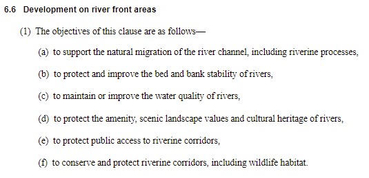
End of the submission.
Assessment officer’s
comments:
The submission maker’s comments are
noted. Several points in the applicant’s
submission require comment and/or clarification as below: -
· The officer acknowledges that subject to an assessment to ensure suitability for an outdoor area or a
swimming pool, Council may grant consent for such ancillary developments
despite not meeting relevant setback requirements;
· As the proposed veranda and the balcony (non-compliant area as per
the submission) are attached to the dwelling, they are identified as part of
the dwelling. It is noted therefore, the proposed additions are required to
comply with the relevant setback provisions as outlined in WLEP 2013;
· As noted previously Council cannot vary Section 6.6 (2)(b) of WLEP
2013;
· The officer acknowledges that the objectives of this Section
(Clause) can be achieved despite not meeting the relevant assessment
guidelines. The above assessment concluded that the proposal will not have
detrimental impacts on the amenity of the river or adjoining neighbours.
3.6(e) The public interest.
The
public interest is a broad consideration relating to many issues and is not
limited to the demand upon public services and infrastructure. Taking into
account the full range of matters for consideration under Section 4.15
(1),(a),(b),(c) and (d) of the Environmental Planning and
Assessment 1979 and it is considered that approval
of the application is inconsistent with the public interest. The applicant
has provided a submission as to why this proposal be supported, however it is
considered that the proposal would remain inconsistent with the Wakool Local
Environment Plan 2013, it is therefore considered that the proposal is not in
the public interest.
Conclusion
The proposed development has been assessed in accordance with the
provisions of the Environmental Planning and Assessment Act 1979, Environmental
Planning and Assessment Regulation 2000, Murray REP 02, Wakool Local
Environmental Plan 2013, and the Wakool Development Control Plan 2013.
As noted above the proposed development results in
non-compliance with Section 6.6 (2)(b) of Wakool Local
Environmental Plan 2013. Should the application be approved the precedent
created by the approval of this application may lead to additional similar
applications been lodged with the Council and is inconsistent with the legal
advice that Council officers have received. It is therefore due to the reason
outlined in the Executive Summary the application is recommended to be refused.
Alternatively,
if Council resolve to approve Development Application 10.2020.360.1 for
extension to existing single storey dwelling including part demolition at Lot:
462 DP: 748396, 161 North Barham Road BARHAM NSW 2732, a deferred
commencement consent is being recommended subject to the conditions outlined in
the attachment four (04).
Attachments
1. DA
10.2020.360.1 - Attachment 01 - Plans ⇩
2. DA
10.2020.360.1 - Attachment 02 - BASIX Certificate ⇩
3. DA
10.2020.360.1 - Attachment 04 - Recommended Conditions ⇩ 
4. Applicant
Submission ⇩ 
|
MURRAY RIVER COUNCIL Ordinary
Council Meeting Agenda
|
23 March 2021
|
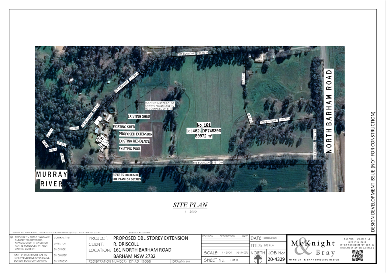
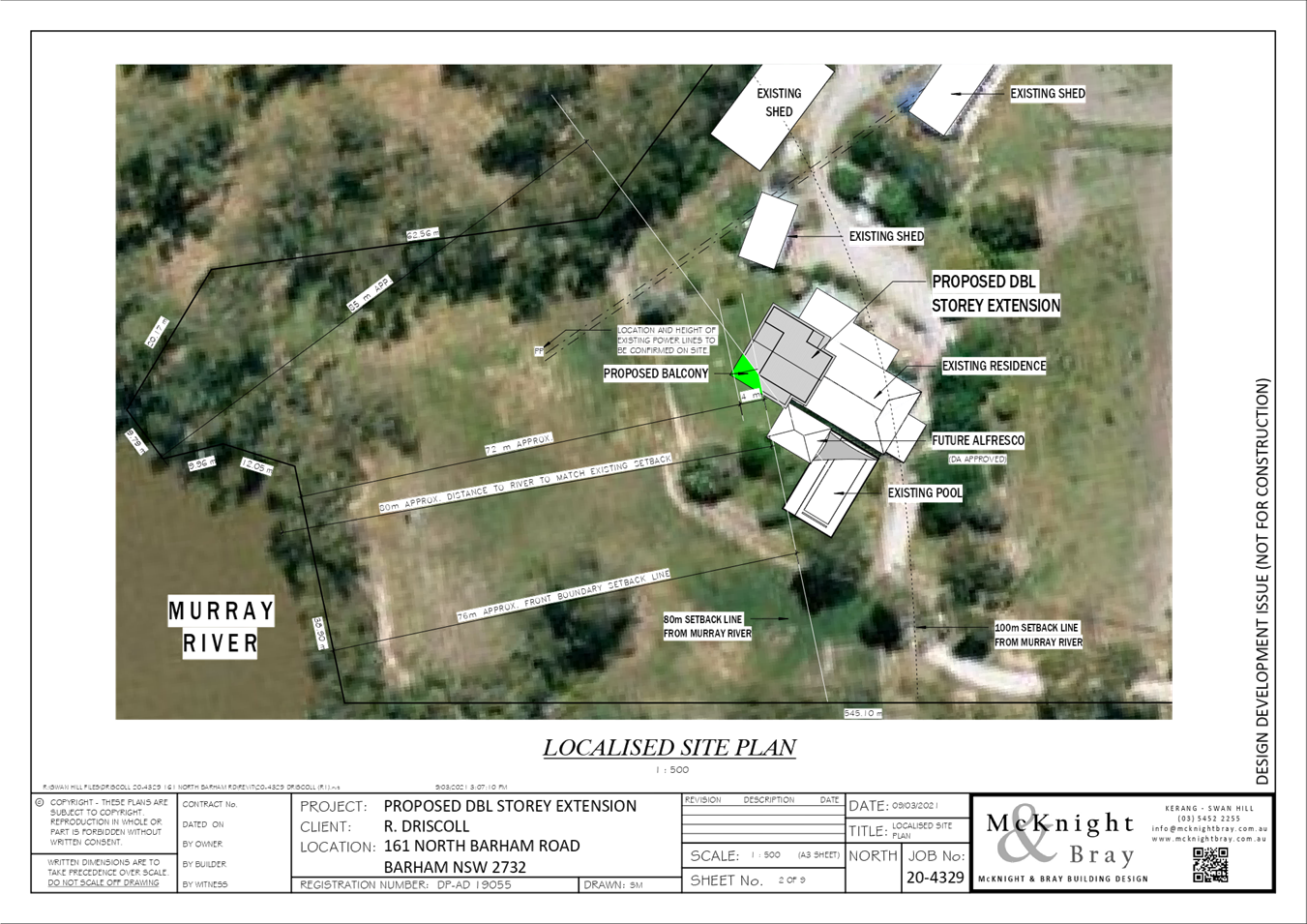
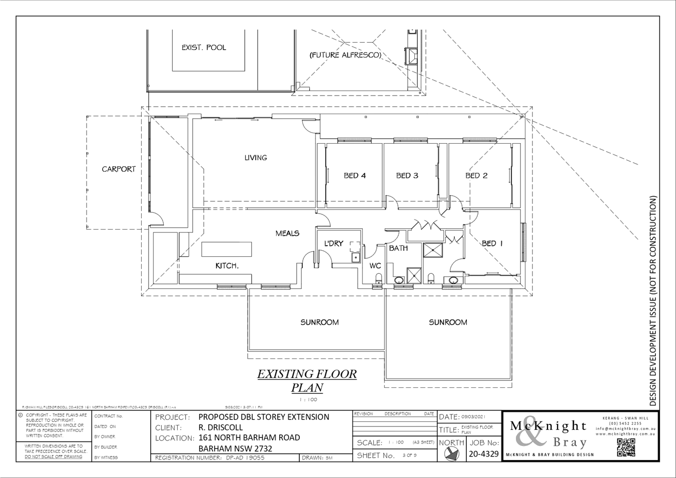
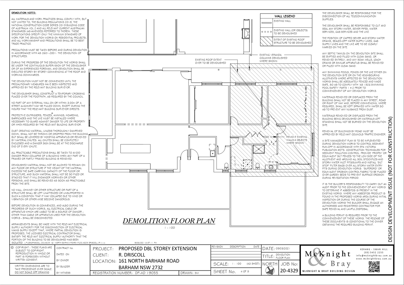
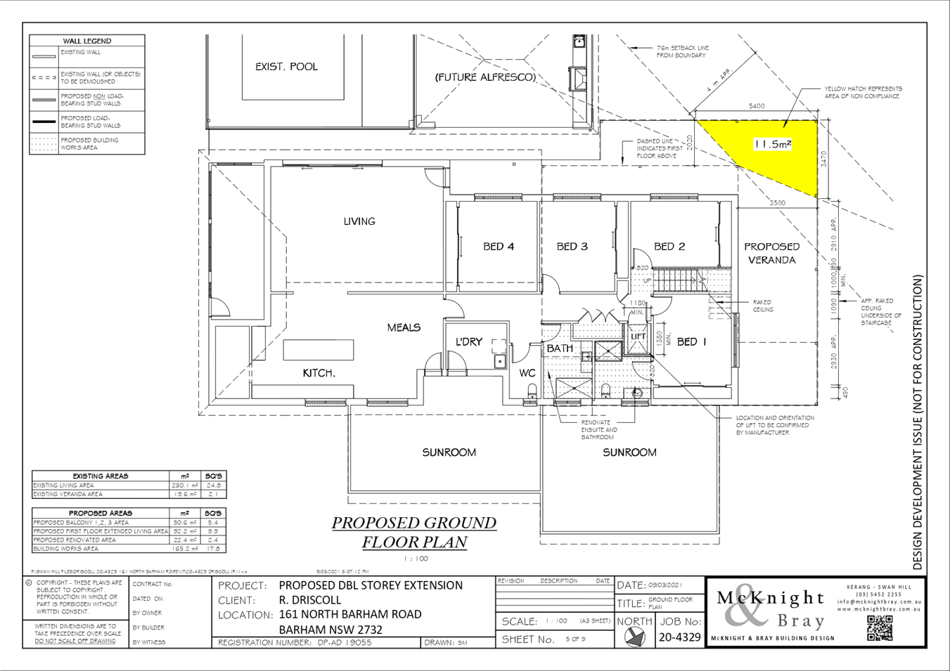
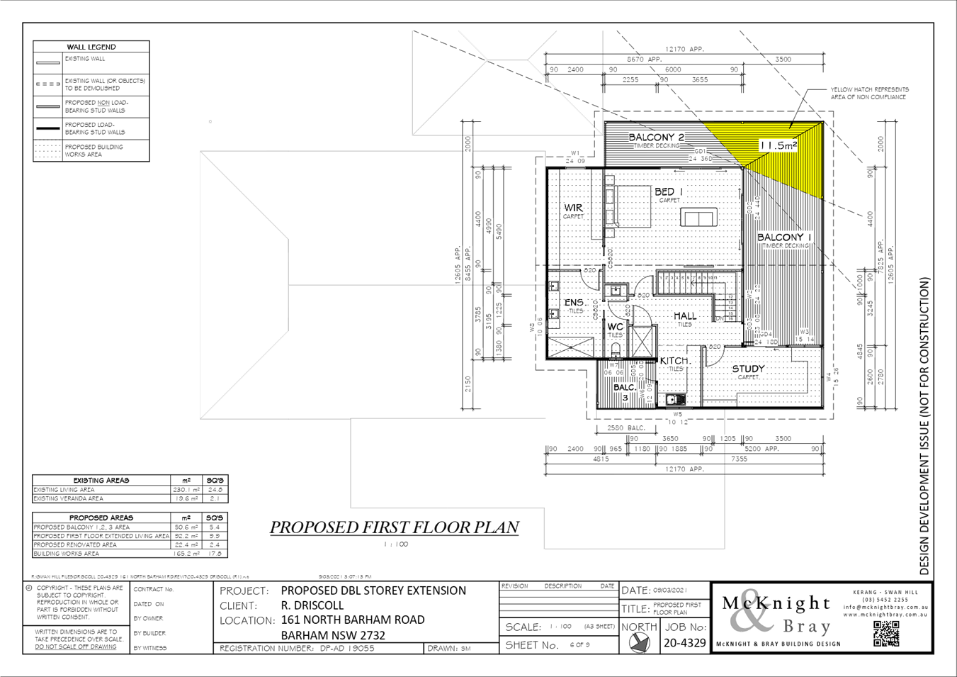

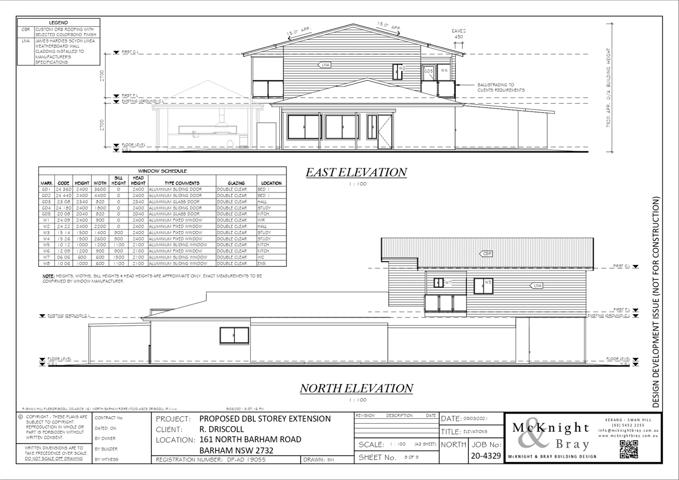
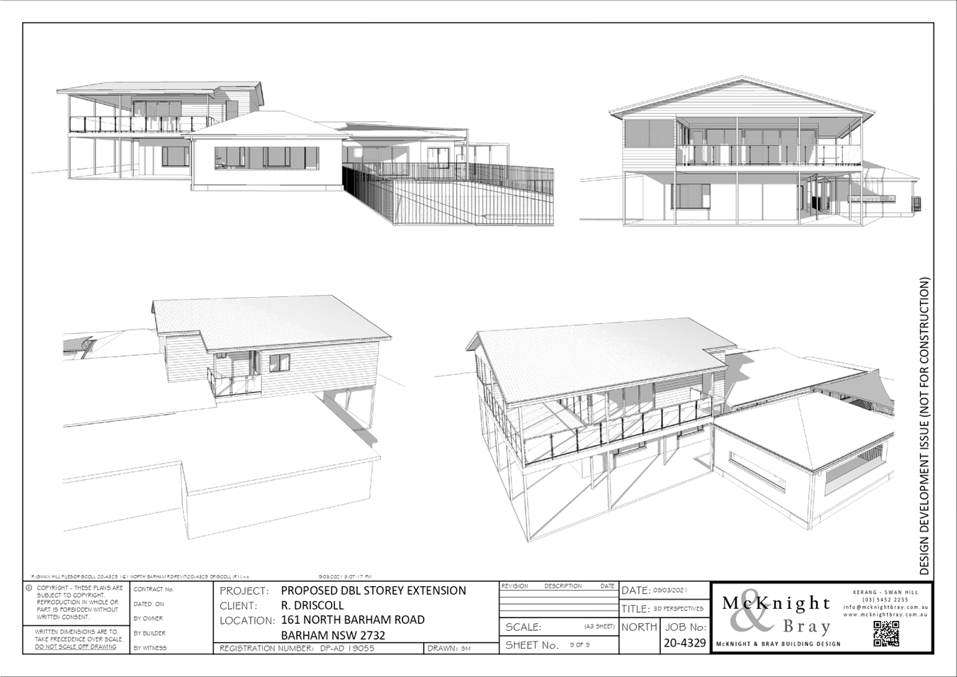
|
MURRAY
RIVER COUNCIL Ordinary Council Meeting Agenda
|
23 March 2021
|
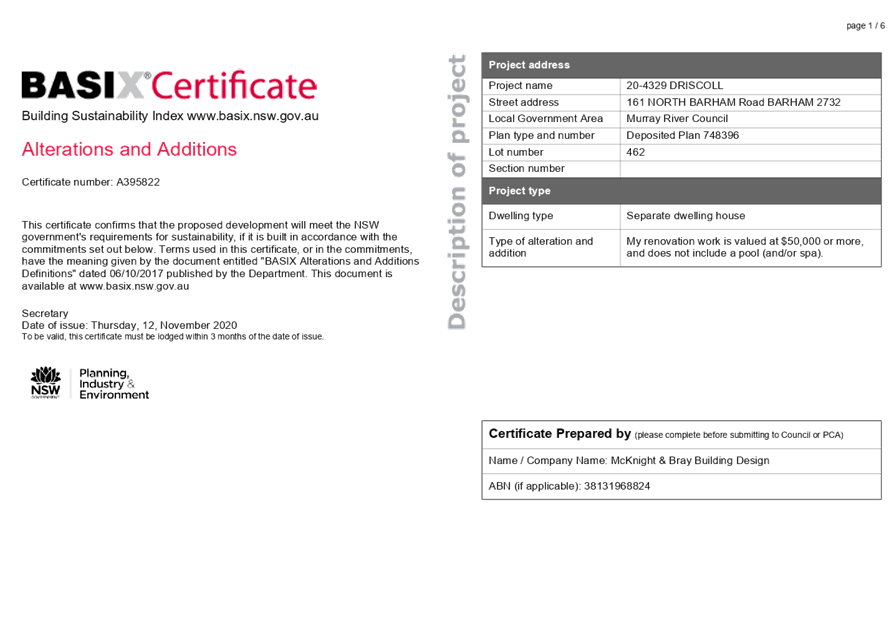
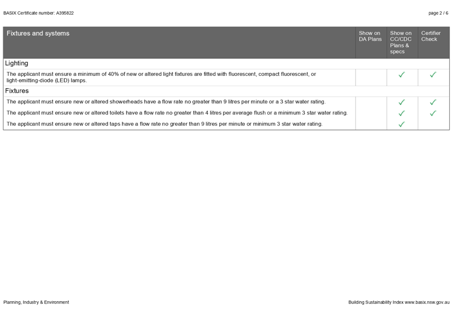
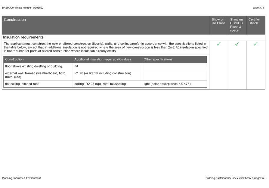
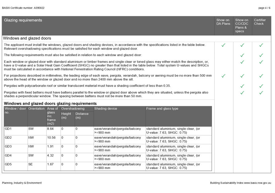
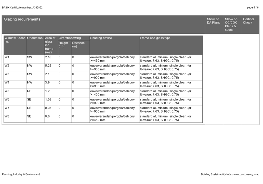
|
MURRAY
RIVER COUNCIL Ordinary Council Meeting Agenda
|
23 March 2021
|
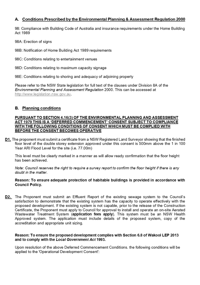
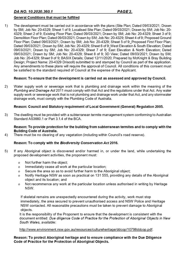

|
MURRAY
RIVER COUNCIL Ordinary Council Meeting Agenda
|
23 March 2021
|

9.5 Director
Community and Economic Development Report and Supplementary Matters
9.5.1 Murray River Council Community
Grants Program – Appointment of Assessment Panel, Round 2, 2020-21
File
Number: -
Author: Beck
Hayward, Economic Development Officer
Authoriser: John
Harvie, Director Community and Economic Development
|
Recommendation
That the Council:
1. Endorse the Chief Executive
Officer, or his nominee, as a member of the Murray River Council Community
Grants Program Assessment Panel.
2. Appoint three (3) Councillors
to the Murray River Council Community Grants Program Assessment Panel to
assess applications in Round 2, 2020-21.
|
Background
Council ran the first round of
the Murray River Council Community Grants Program in September 2018 and awarded
$38,693.52 in grants.
At its 27 November 2018 meeting,
Council agreed to run two rounds per financial year, allocating $30,000 to each
round.
The Community Grant rounds held
so far have had the following assessment panels:
|
Round 1
2018/19
|
• Des
Bilske, General Manager;
• Cr
Nikki Cohen;
• Cr
Alan Mathers; and
• Cr
Thomas Weyrich.
|
|
Round 2
2018/19
|
• Des
Bilske, General Manager;
• Cr
Ann Crowe;
• Cr
Tony Aquino; and
• Cr
Nikki Cohen.
|
|
Round 1
2019/20
|
• John
Harvie (delegate for Des Bilske, General Manager);
• Cr
Gen Campbell;
• Cr
Neil Gorey; and
• Cr
Weyrich.
|
|
Round 2
2019/20
|
• John
Harvie (delegate for Des Bilske, General Manager);
• Cr
Gen Campbell;
• Cr
Ann Crowe; and
• Cr
Geoff Wise;
|
|
Round 1
2020/21
|
• John
Harvie (delegate for Des Bilske, General Manager);
• Cr
Tony Aquino;
• Cr
Geoff Wise
• Cr
Alan Mathers
|
Round 2 of the 2020/21 Murray
River Council Community Grants Program opened on 23 February 2021. The timeline
for this round (see table below) will require the Assessment Panel to assess
applications between 12 April and 11 May 2021. Assessment of the applications
will be undertaken both online and via a meeting and discussion.
Appointment of the Assessment
Panel at Council’s March 2021 meeting will assist in the smooth planning
of the assessment process.
Round 2 – Timeline
|
23 February 2021
|
Applications open
|
|
4pm, 8 April 2021
|
Applications close
|
|
11 May 2021
|
Assessment of applications
completed
|
|
25 May 2021
|
Council to approve funding for
recommended projects
|
|
June 2021
|
Applicants notified of outcome
|
|
June 2021
|
Successful applicants to submit
invoice for payment
|
|
By 30 June 2022
|
Projects completed and funding
acquittal submitted
|
|
23 February 2021
|
Applications open
|
Discussion
The grants are competitive in
nature as Council will generally receive applications with a total value more
than the $30,000 allocated for the round.
As a result, it is necessary
that Council form an assessment panel to review the grant applications and make
recommendations in relation to which applications should be funded and to what
amount.
Council’s Economic
Development Officer, Beck Hayward, manages the grant program and will assist the
assessment panel during the assessment process.
Strategic Implications
3 - Strategic Theme 3: Social Wellbeing
3.1 - Enable community access to services, programs and facilities
to support and enhance health, wellbeing, and community safety
3.1.5 - Plan for, provide, maintain, improve, and encourage
access to sporting facilities, recreational grounds, parks and gardens, natural
bushlands to create active and passive environments for enjoyment of residents
and visitors
Budgetary Implications
Council has
allocated $30,000 per round for each of the two community grant rounds per
year, (as per 27 November 2018 resolution of Council).
Policy Implications
The grant program process falls
under the Murray River Council Community Financial Assistance Policy (POL109).
Legislative Implications
Nil.
Risk Analysis
· What
can happen?
Nil
· How
can it happen?
Nil
· What
are the consequences of the event happening?
Nil
· What
is the likelihood of the event happening?
Nil
· Adequacy
of existing controls?
Nil
· Treatment
options to mitigate the risk?
Nil
Conclusion
Council needs
to appoint members to the Murray River Council Community Grants Program Assessment
Panel, to enable the assessment process to proceed smoothly and on time.
Attachments
Nil
9.5.2 Echuca
Moama Family History Group - request to occupy Moama's Old Telegraph Station
File
Number: -
Author: Beck
Hayward, Economic Development Officer
Authoriser: John
Harvie, Director Community and Economic Development
|
Recommendation
That Council support the Echuca Moama Family History
Group’s proposed move to occupy Moama’s Old Telegraph
Station.
|
Background
The Echuca Moama Family History Group (EMFHG) focus on the
collection, restoration and storage of local history, records, and information
for the use of the community. The aim of the EMFHG is to encourage and support
all members in tracing their ancestors and to encourage and promote an interest
in genealogy in a social environment. They provide professional research for
locals and international researchers relating to Echuca and surrounds and the
following areas of Murray River Council: Bunnaloo, Caldwell, Mathoura, Moama,
Thyra and Womboota.
The information they hold is used to help members of the
community to trace families and learn about the heritage of our nation, with an
emphasis on the gathering of information about our local area. EMFHG is a
voluntary organisation with around 50 members, they fundraise to cover costs,
and to replace equipment needed to carry out their work. The group have opened
their research rooms to the public two days a week for the past 14 years while
operating from their current location at 9 Murray Esplanade.
For various reasons the group need to find a new location
from which to operate. The Friends of Old Moama, who are a section 355
committee looking after the Old Telegraph Station (OTS), believe the OTS could
be a perfect location for the EMFHG to operate from.
Refer to attached background documents.
Discussion
The Friends of Old Moama invited the EMFHG president to
their February committee meeting and the committee formally agreed that having
the EMFHG occupy the Old Telegraph Station would bring many benefits to both
groups and the community.
If Council agree to support this move, a formal user
agreement would be put in place.
Strategic Implications
1 - Strategic Theme 1: Built/Physical Environment
1.1 - Improve and maintain our built town environments
1.1.3 - Identify and preserve heritage buildings,
historically and culturally significant sites, including Aboriginal sites
Budgetary Implications
The EMFHG would not pay rent to occupy the OTS space, they
would pay for any expenses they incur (e.g. power).
The EMFHG require more power points at the OTS to support
their operations. They have met with Council’s Asset Inspector and
Maintenance Coordinator, Dave Dundee, and Dave has received a quote from an
electrician to install the power points ($1,446). The EMFHG are willing to
cover the cost of this, should Council approve the move.
Council has an annual allocation for maintenance at the Old
Telegraph Station.
The user agreement will specify responsibilities for any
expenses.
Policy Implications
Nil.
Legislative Implications
Risk Analysis
· What
can happen?
The EMFHG move in to the OTS and
disputes occur.
· How
can it happen?
Lack of detail in the formal
agreement, or unforeseen issues arising.
· What
are the consequences of the event happening?
Dispute between
Friends of Old Moama and EMFHG
· What
is the likelihood of the event happening?
Low
· Adequacy
of existing controls?
User agreement
is not yet in place. Current use arrangements for the building works well.
· Treatment
options to mitigate the risk?
Ensure a detailed user agreement
is in place.
Conclusion
The Friends of Old Moama and the Echuca Moama Family History
Group are both supportive of the EMFHG moving their not-for-profit operations
to Moama’s Old Telegraph Station and are seeking Council’s support
for this move.
A formal user agreement would be drawn up by Council, should
this move proceed.
Attachments
1. EMFHG
- letter ⇩ 
2. EMFHG
- background ⇩ 
|
MURRAY RIVER COUNCIL Ordinary
Council Meeting Agenda
|
23 March 2021
|
|
MURRAY
RIVER COUNCIL Ordinary Council Meeting Agenda
|
23 March 2021
|

9.5.3 Barham
Micro Abattoir Update
File
Number: -
Author: John
Harvie, Director Community and Economic Development
Authoriser: Terry
Dodds, Chief Executive Officer
|
Recommendation
That Council
1. Approve the lease
document and delegate authority to the Mayor and Chief Executive Officer to
sign and apply the council seal.
|
Background
At councils monthly meeting held on 26 October 2020 council
resolved to:
1. Accept
the $2,209,000 total funding offered through the Growing Local Economies
Program, the Drought Communities Program and the Murray Darling Basin Economic
Development Program and authorise the CEO and Mayor to sign the funding
agreements and apply the council seal where required.
2. Approve
proceeding with the Barham Micro-Abattoir Project.
At that same
meeting council were provided with a copy of the proposed draft lease agreement
between MRC and Murray Plains Meat Cooperative.
Discussion
In the intervening time council solicitors have completed
purchase of the 4Ha abattoir site on Lot 1 DP1267277 at 123 Gonn Road Barham
NSW 2732 and finalised the lease agreement with Murray Plains Meat Cooperative.
A copy of the lease is an attachment to this report.
Tender documentation for design and construction has been
prepared and issued and acceptance of tenders close on 23 March 2021.
On the ground, the site has been fenced and quotes for the
site access road construction, electricity supply and water supply have been
sought.
Strategic Implications
4 - Strategic Theme 4: Economic Growth
4.1 - Encourage and support economic development across a
range of sectors
4.1.3 - Identify new opportunities and actively encourage
investment in agriculture, agribusiness, value added manufacturing, alternate
and renewable energy, health, wellbeing, aged care, and education
Budgetary Implications
The project is fully funded by grant funds through the following
programs:
Drought Communities Program
Murray Darling Basin Economic Development Program and
Growing local Economies Program
Policy Implications
Nil.
Legislative Implications
Risk Analysis
· What
can happen?
Insufficient funds
· How
can it happen?
Tendered costs greater than funds
available.
· What
are the consequences of the event happening?
Murray Plains
Meat Cooperative will have to source additional funds
· What
is the likelihood of the event happening?
Possible
· Adequacy
of existing controls?
Adequate
· Treatment
options to mitigate the risk?
Manage
Conclusion
Murray Plains Meat Cooperative (MPMC) have provided council
with freehold title to the proposed micro abattoir site at 123 Gonn Road Barham
2732. To conclude the contractual arrangements between Council and MPMC council
is required to approve and sign the lease agreement.
Attachments
1. Murray
Plains Meat Cooperative Draft Lease Agreement - Confidential
9.5.4 Site of the
future Moama Preschool development
File
Number: -
Author: Beck
Hayward, Economic Development Officer
Authoriser: John
Harvie, Director Community and Economic Development
|
Recommendation
That Council endorse the alternative site proposed for the
future Moama Preschool development.
|
Background
In August 2019 Council agreed to seek approval from NSW
Crown Lands for 2.0Ha of land, located on the Moama Recreation Reserve near the
corner of Lignum Lane and Boyes Street, to be provided for the future
development of the new Moama Preschool.
Since that time the project has progressed with concept
plans developed, funding applications submitted, a $1.5M grant received from
NSW Government, a planning proposal submitted to the Department of Planning and
architects engaged to draw the detailed plans and progress the Development
Application to approval.
During this process staff have identified the need to shift
the location of the proposed preschool development, within the Moama Recreation
Reserve. The proposed location is one hectare in size and aituated along Boyes
St to the north of the recreation reserve. Please refer to attached plan
showing the initial location and the proposed location.
Discussion
The reasoning behind the proposed relocation includes:
1. Feedback
(from NSW Department of Planning) on the planning proposal (to change the
parcel of land from Community Land to Operational land) noted that loss of
recreational space will be a significant consideration when assessing the
proposal. The new site was set aside for drainage purposes and therefore will
not result in any loss of recreational land. This will increase the likelihood
of the planning proposal being approved.
2. The
new site is adjacent to the Moama Anglican Grammar and will be more central to
the new Catholic school development.
3. The
proposed site has improved traffic and access conditions.
4. The
proposed location allows for potential combination of other complimentary uses
(e.g. multipurpose facility), to the north of the recreation reserve.
5. Alignment
with development to the north, including roadway access.
Strategic Implications
3 - Strategic Theme 3: Social Wellbeing
3.1 - Enable community access to services, programs and
facilities to support and enhance health, wellbeing, and community safety
3.1.4 - Develop community-based plans for appropriate
facilities and services (including variable use of facilities) to meet current
and future needs of each community
Budgetary Implications
The new site will require a 500m section of Boyes Road to be
sealed. The cost of this (approximately $200,000) has been included in the
total project cost, as part of the recent grant application under the Building
Better Regions Fund (round 5).
Both the previous site and the new site require service connections,
so the cost to develop each site will be similar.
Policy Implications
Nil.
Legislative Implications
Both sites require a Planning Proposal be submitted to the
Department of Planning, this is underway.
Risk Analysis
· What
can happen?
The planning proposal (to change
the parcel of land from Community Land to Operational land) is rejected.
· How
can it happen?
Insufficient information provided
to the Department of Planning.
· What
are the consequences of the event happening?
The site cannot
be used for the preschool development.
· What
is the likelihood of the event happening?
Medium.
· Adequacy
of existing controls?
Adequate.
· Treatment
options to mitigate the risk?
Ensure a thorough and detailed
planning proposal is submitted. This is currently being put together.
Conclusion
Council should support the alternative site proposed for the
future Moama Preschool development.
Attachments
1. Proposed
new location including drainage layout ⇩
|
MURRAY RIVER COUNCIL Ordinary
Council Meeting Agenda
|
23 March 2021
|
9.5.5 Section 355
Committee Reports - March 2021
File Number:
-
Author: Sarah
Ryan, Grants Officer
Authoriser: John
Harvie, Director Community and Economic Development
|
Recommendation
That Council receive the report on Section 355 Committee
Minutes and note the contents of the minutes.
|
Background
Council Section 355 Committees are to provide minutes of
each committee meeting to keep council informed of the committee’s
activities.
Discussion
Some, but not all, committees comply with this requirement.
Over the next 12 months, the Director of Community and Economic Development
will work with all committees to help them meet their obligations as required
by s355 of the Local Government Act 1993.
The minutes received by council during the period
February-March are attached for council’s information.
Strategic Implications
5 - Strategic Theme 5: Leadership and Governance
5.3 - Communication and collaboration identifies and meets
community needs
5.3.1 - Council clearly identifies and promotes simple,
effective communication, consultation and participation for community
Budgetary Implications
Nil.
Policy Implications
Nil.
Legislative Implications
Risk Analysis
· What
can happen?
Nil.
· How
can it happen?
NA
· What
are the consequences of the event happening?
NA
· What
is the likelihood of the event happening?
NA
· Adequacy
of existing controls?
NA
· Treatment
options to mitigate the risk?
NA
Conclusion
A great deal more engagement with s355 committees is now in
place however COVID-19 restrictions are causing some inactivity.
Attachments
1. Section
355 Committee Reports - As at March 2021 (under separate cover) 
9.5.6 Grant
Funding Report - March 2021
File
Number: -
Author: Sarah
Ryan, Grants Officer
Authoriser: John
Harvie, Director Community and Economic Development
|
Recommendation
That Council receive and note the March 2021 Funding
Report.
|
Background
The purpose of this report is to provide an update on
current business and community funding opportunities.
Discussion
Council has received funding under the following
programs:
NSW Government - Crown Reserves Improvement Fund
The purpose of this funding is to improve Crown Asset
Reserves for the benefit of the community:
|
Murray River Council
|
Barham Recreation Reserve
Stabilisation and upgrade of internal road, upgrade
existing amenities pavilion and purchase and install of new BBQ facilities
|
$115,000 (inc GST)
|
|
Horseshoe Lagoon
Upgrade existing pedestrian footbridge
|
$95,000 (inc GST)
|
|
Picnic Point Caravan Park
Upgrade failing retaining wall
|
$140,000 (inc GST)
|
|
Moulamein Centennial Recreation Reserve
Construction of multi purpose shelter pavilion, toilet
block and renovation to the catering and admin building
|
$266,770 (inc GST)
|
|
Barham Bowling Club
Purchase and install of solar lighting along new shared
path
|
$35,000 (inc GST)
|
NSW Department of Planning, Industry and Environment
– Phase 2 Crown Lands
Showgrounds Stimulus Funding Program
|
Murray River Council
|
Moama Recreation Reserve
Main oval carpark, brick alley carpark, filtered water
stations and perimeter seating
|
$390,500 (inc GST)
|
The purpose of this program is to maximise opportunities for
economic growth relating to showgrounds.
NSW EPA ~ Organics
Infrastructure Fund
This program funds new or improved local council household
kerbside collection services for food and garden
organics, including collection systems for garden only, food waste, or a
combination of both.
|
Murray River Council
|
FOGO Organics Collections
|
$321,914
|
Credit to Gavin Carlisle and his team.
Transport for NSW ~ Fixing Country Bridges Program
This program aims to support Councils by reducing the
maintenance burden of ageing timber bridges across regional NSW.
|
Murray River Council
|
Jimaringle Creek Bridge – Rangemore Road, Tullakool
|
$450,000
|
|
Barber Creek Bridge ~ Sandys Bridge Road, Barham
|
$1,200,000
|
|
Merran Creek Bridge – Drysdale Lane, Gonn
|
$900,000
|
|
Murrain Yarrein Creek Bridge – Frasers Road, Niemur
|
$970,000
|
|
Yarrein Creek Bridge – Torranie Road, Mallan
|
$1,300,000
|
Credit to Onisimo Mukodi, Manager Design, Capital Works
& Projects.
Council has recently applied for funding under the
following programs:
|
Building Better Regions Fund – Round 5
|
Moama Foreshore
|
$1,124,000
|
|
Moama Preschool
|
$2,902,469
|
|
Civil Construction Market Program
|
Multi Shredder
|
$250,000
|
Grants Hub
Council has launched a Grants Hub for all businesses,
community groups and not-for-profits located in the Murray River Council local
government area.
The Grants Hub provides a comprehensive list of all grant
and funding opportunities available Australia wide. Grants from many
sources are listed including:
· Federal government
grants;
· State government
grants;
· Local government
grants;
· Corporate grants;
and
· Philanthropic
grants.
This free services means our customers will never miss a
grant opportunity again, with the ability to receive email alerts for new
grants, save your favourites and receive up-to-date information to assist you
in applying for grants.
The link can be found on Council’s website: https://murrayriver.grantguru.com.au/
Strategic Implications
4 - Strategic Theme 4: Economic Growth
4.1 - Encourage and support economic development across a
range of sectors
4.1.2 - Support the local business sector to grow, adapt and
respond to new opportunities
Budgetary Implications
Council contributions as budgeted.
Policy Implications
Nil.
Legislative Implications
Risk Analysis
· What
can happen?
Nil
· How
can it happen?
NA
· What
are the consequences of the event happening?
NA
· What
is the likelihood of the event happening?
NA
· Adequacy
of existing controls?
NA
· Treatment
options to mitigate the risk?
NA
Conclusion
Current community and business opportunities can be found
via Council’s Grants Hub and have been distributed via the Economic
Development, Community and Tourism database.
Attachments
Nil
9.6 Correspondence
Report
9.6.1 Correspondence Report
File
Number: -
Author: Lindy
Leyonhjelm, Executive Assistant
Authoriser: Terry
Dodds, Chief Executive Officer
|
Recommendation
That the Correspondence Report be received and the information noted by the Council.
|
Discussion
Office of Local Government
· OLGNSW
COVID-19 Council Update – 10 Feb 2021
· OLGNSW
COVID-19 Council Update – 5 Mar 2021
· OLGNSW
COVID-19 Council Update – 10 Mar 2021
MINISTER HANCOCK OLGNSW
Fortnightly Newsletter
· OLG’s
Fortnightly Newsletter – 19 Feb 2021
· OLG’s
Fortnightly Newsletter – 5 Mar 2021
RDA ORANA NSW
· Weekly
Newsletter – 25 Feb 2021
HELEN DALTON MP
· Mutual
Recognition of Building Surveying Qualifications – 10 Mar 2021
Attachments
1. OLGNSW
COVID-19 Council Update – 10 Feb 2021 ⇩ 
2. OLGNSW
COVID-19 Council Update – 5 Mar 2021 ⇩
3. OLGNSW
COVID-19 Council Update – 10 Mar 2021 ⇩ 
4. OLG’s
Fortnightly Newsletter – 19 Feb 2021 ⇩
5. OLG’s
Fortnightly Newsletter – 5 Mar 2021 ⇩ 
6. Weekly
newsletter RDA Orana NSW 25 Feb 2021 ⇩
7. Helen
Dalton MP 090321 Mutual Recognition of Building Surveying qualificaitons ⇩
|
MURRAY RIVER COUNCIL Ordinary
Council Meeting Agenda
|
23 March 2021
|

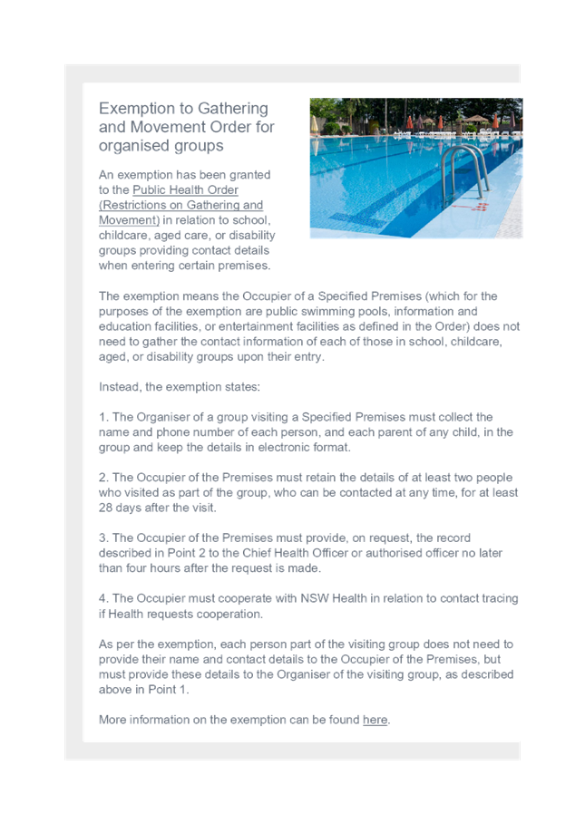

|
MURRAY
RIVER COUNCIL Ordinary Council Meeting Agenda
|
23 March 2021
|
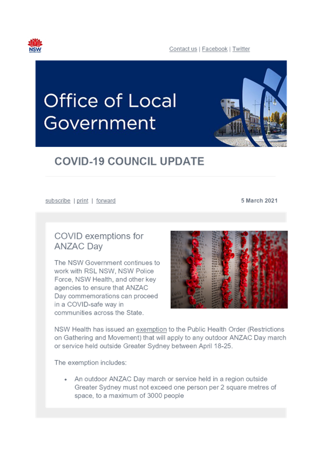
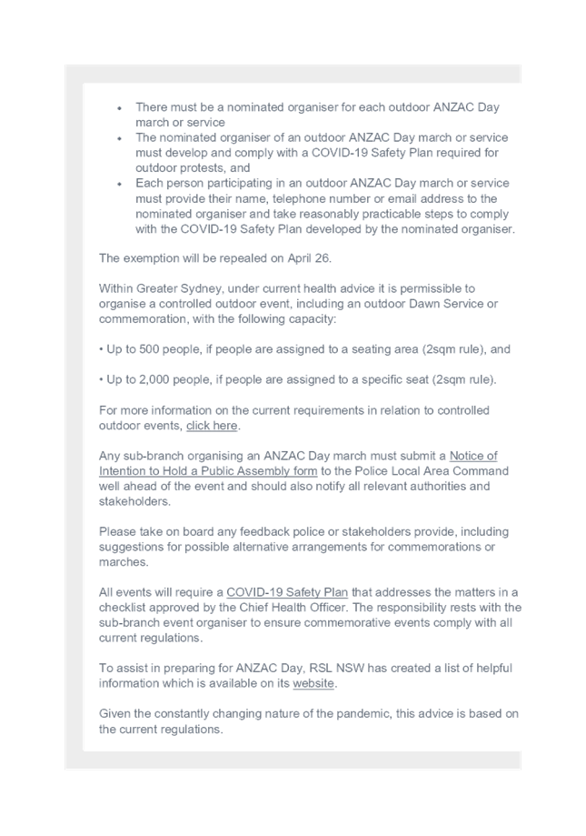

|
MURRAY
RIVER COUNCIL Ordinary Council Meeting Agenda
|
23 March 2021
|
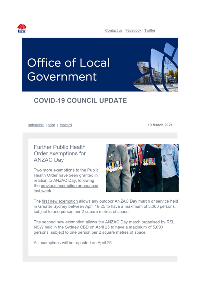

|
MURRAY
RIVER COUNCIL Ordinary Council Meeting Agenda
|
23 March 2021
|
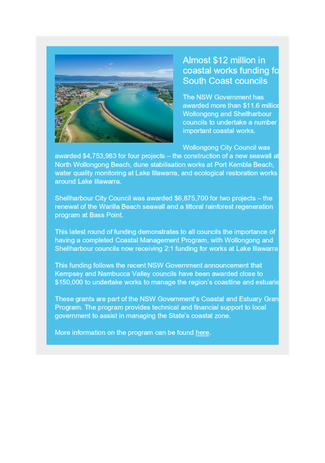
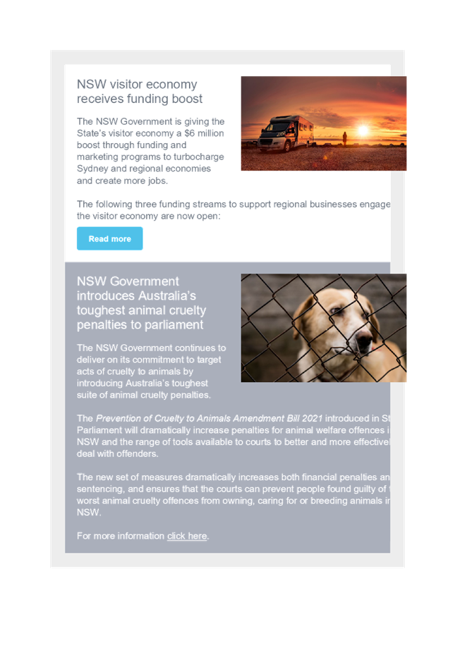
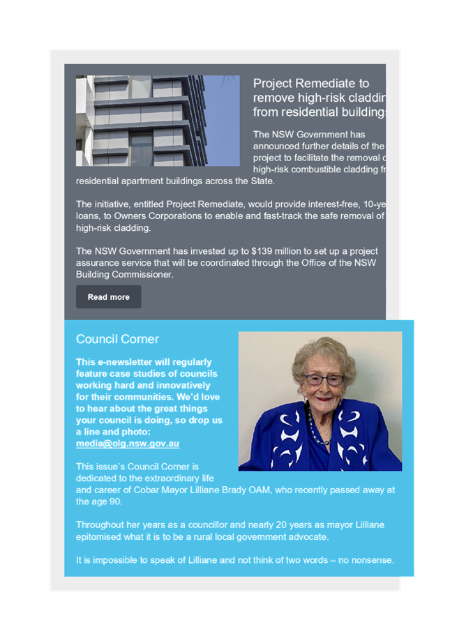

|
MURRAY
RIVER COUNCIL Ordinary Council Meeting Agenda
|
23 March 2021
|

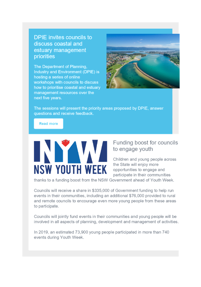
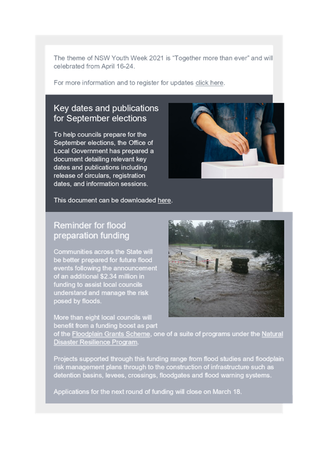

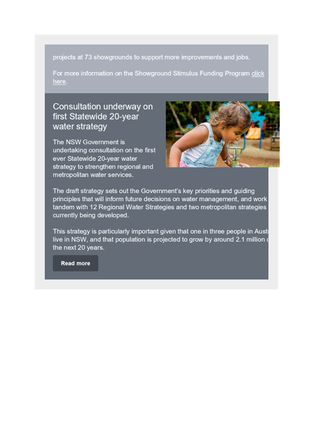
|
MURRAY
RIVER COUNCIL Ordinary Council Meeting Agenda
|
23 March 2021
|


|
MURRAY
RIVER COUNCIL Ordinary Council Meeting Agenda
|
23 March 2021
|
9.7 Sundry
Delegates Report
9.7.1 Sundry Delegates Report
File
Number: -
Author: Lindy
Leyonhjelm, Executive Assistant
Authoriser: Terry
Dodds, Chief Executive Officer
|
Recommendation
That the Sundry Delegates Report of
the Mayor and Councillors for the period 23 February 2021 to 22 March 2021 be noted by the Council; and reasonable out of pocket
expenses be met by Council.
|
Discussion
The
Mayor, Councillor Chris Bilkey reported on his attendance at the following
meetings and functions:
· 23 Feb Pre-briefing and Ordinary
Council Meeting of Council – Moama
· 24 Feb Meet with Adrian Barber
– CLRS Echuca
· 24 Feb Radio interview 2QN –
Echuca
· 24 Feb Weekly Council update
– Moama
· 27 Feb Attendance at Barham Skate
Park
· 1 Mar Dinner with Hon
Keith Pitt MP and Senator Perin Davey – Deniliquin
· 2 Mar RAMJO Water
Committee luncheon Hon Keith Pitt MP – Mathoura
· 3 Mar Radio interview
2QN – Echuca
· 3 Mar SWA Hub Opening
· 3 Mar Weekly Council
update – Moama
· 5 Mar Meeting with
Small Business Commissioner Helen Nezeritis & Mark Frost – via
Teams
· 5 Mar Participation in
Ageing Well Project
· 8 Mar Interview with
Riverine Herald
· 10 Mar Meeting with the Hon Emma
Hurst via teams
· 11 Mar Interview with Riverine
Herald
· 13 Mar Attendance at Basketball
event – Moama
· 22 Mar Meeting with Bridgett
Leopold from RAMJO - Moama
The
Deputy Mayor, Councillor Nikki Cohen reported on her attendance at the
following meetings and functions:
· 23 Feb Pre-briefing and Ordinary
Council Meeting of Council – Moama
· 3 Mar Meeting with MRC
CEO – Moama
· 7 Mar Presidents
Luncheon – Echuca Moama Racing Club – Echuca
· 9 Mar Moama
Recreational Reserve Meeting – Moama
· 10 Mar Weekly Councillor Update
– via Teams
· 12 Mar EMFM Radio interview –
Echuca
· 16 Mar Liquor Accord Meeting -
Moama
· 17 Mar Weekly Councillor Update
– via Team
· 18 Mar CT Management, Service Planning
Workshop - Moama
Councillor
Tony Aquino reported on his attendance at
the following meetings and functions:
· 23 Feb Pre-briefing and Ordinary
Council Meeting of Council – Moama
· 3 Mar Weekly Councillor
Update – via Teams
· 10 Mar Weekly Councillor Update
– via Teams
· 17 Mar Weekly Councillor Update
– via Team
· 18 Mar CT Management, Service Planning
Workshop - Moama
Councillor Gen Campbell reported on her attendance at the following meetings and
functions:
· 23 Feb Pre-briefing and Ordinary
Council Meeting of Council – Moama
· 18-20 Mar Attendance
to ALGWA NSW State Conference - Shellharbour
Councillor Alan Mathers reported on his attendance at the following meetings and
functions:
· 23 Feb Pre-briefing and Ordinary
Council Meeting of Council – Moama
Councillor Ann Crowe reported on her attendance at the following meetings and
functions:
· 23 Feb Pre-briefing and Ordinary
Council Meeting of Council – Moama
Councillor Neil Gorey reported on his attendance at the following meetings and
functions:
· 23 Feb Pre-briefing and Ordinary
Council Meeting of Council – Moama
Councillor Thomas Weyrich reported on his attendance at the following meetings and
functions:
· 23 Feb Pre-briefing and Ordinary
Council Meeting of Council – Moama
Councillor
Geoff Wise reported on his attendance at
the following meetings and functions:
· 23 Feb Pre-briefing and Ordinary
Council Meeting of Council – Moama
· 3 Mar Weekly Council
Update – Moama
· 4 Mar Bunnaloo hall
Committee meeting
· 9 Mar Lions Club
Committee meeting
Attachments
Nil
10 Notice
of Motions/Questions with Notice
10.1 Notice
of Motion - High level traffic plan with future proofing for increase in
traffic be discussed and implemented
File
Number: -
I, Councillor Thomas Weyrich, give notice that at the next
Ordinary Meeting of Council to be held on 23 March 2021, I intend to move the
following rescission motion:-
|
Motion
That Council develop a high-level traffic management plan,
including future proofing, stemming from current and proposed land
developments.
|
Rationale
I commend this Notice of Motion to Council.
Attachments
Nil
10.2 Notice
of Motion - Council receive a report on the progress of the Meninya st precinct
and Fast tracking from concept to delivery
File
Number: -
I, Councillor Thomas Weyrich, give notice that at the next
Ordinary Meeting of Council to be held on 23 March 2021, I intend to move the
following rescission motion:-
|
Motion
That Council receive a report on the progress of the
Meninya Street precinct developments, including methodology underpinning
potential ways to fast-track from ‘Concept’ to
‘Implementation’.
|
Rationale
I commend this Notice of Motion to Council.
Attachments
Nil
11 Confidential
Matters
|
Recommendation
That Council considers the confidential report(s) listed
below in a meeting closed to the public in accordance with Section 10A(2) of
the Local Government Act 1993:
11.1 Code of Conduct
Investigation 1
This matter is considered to be confidential under Section
10A(2) - i of the Local Government Act, and the Council is satisfied that
discussion of this matter in an open meeting would, on balance, be contrary
to the public interest as it deals with alleged contraventions of any code of
conduct requirements applicable under section 440.
11.2 Code of Conduct
Investigation 2
This matter is considered to be confidential under Section
10A(2) - i of the Local Government Act, and the Council is satisfied that
discussion of this matter in an open meeting would, on balance, be contrary
to the public interest as it deals with alleged contraventions of any code of
conduct requirements applicable under section 440.
11.3 Rent Waiver
Considerations - Commercial Caravan Parks
This matter is considered to be confidential under Section
10A(2) - d(ii) of the Local Government Act, and the Council is satisfied that
discussion of this matter in an open meeting would, on balance, be contrary
to the public interest as it deals with information that would, if disclosed,
confer a commercial advantage on a competitor of the council.
|